Possible subtropical storm in central atl (Is invest 95L)

This is the general tropical discussion area. Anyone can take their shot at predicting a storms path.

Moderator: S2k Moderators

Forum rules

The posts in this forum are NOT official forecasts and should not be used as such. They are just the opinion of the poster and may or may not be backed by sound meteorological data. They are NOT endorsed by any professional institution or STORM2K. For official information, please refer to products from the National Hurricane Center and National Weather Service.

Help Support Storm2K
Message
Author
User avatar
TheEuropean
Professional-Met
Professional-Met
Posts: 1793
Age: 58
Joined: Tue Sep 20, 2005 3:17 pm
Location: Voerde, Germany
Contact:

Possible subtropical storm in central atl (Is invest 95L)

#1 Postby TheEuropean » Sat Sep 27, 2008 2:36 am

A strong system in the central atlantic may become a subtropical system in the next few days:

Image
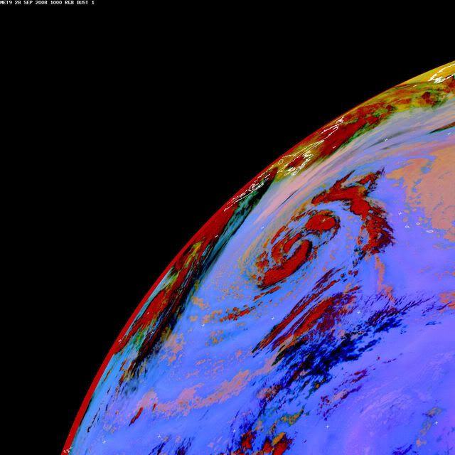
(Sep. 27th, 0600Z, University of Dundee)
0 likes   

User avatar
Chacor
Category 5
Category 5
Posts: 10229
Joined: Mon Oct 02, 2006 10:43 pm
Location: Singapore

#2 Postby Chacor » Sat Sep 27, 2008 3:16 am

Still very frontal now.
0 likes   

User avatar
TheEuropean
Professional-Met
Professional-Met
Posts: 1793
Age: 58
Joined: Tue Sep 20, 2005 3:17 pm
Location: Voerde, Germany
Contact:

Re:

#3 Postby TheEuropean » Sat Sep 27, 2008 6:06 am

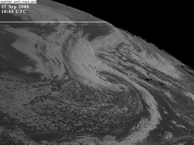
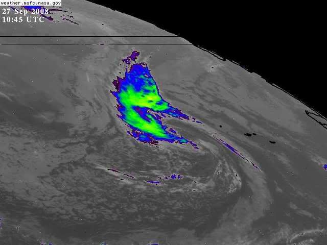
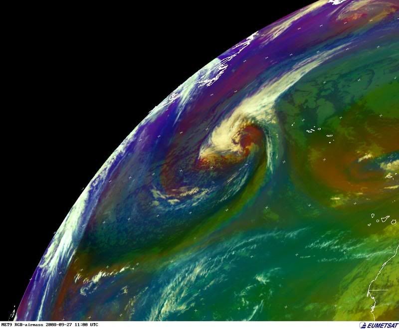
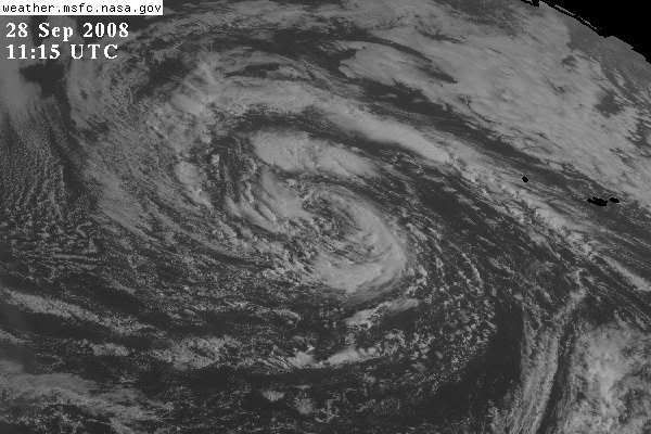
Chacor wrote:Still very frontal now.


Yes, but it may become a subtropical system in the next few days and this low is something to watch.
0 likes   

User avatar
HURAKAN
Professional-Met
Professional-Met
Posts: 46086
Age: 37
Joined: Thu May 20, 2004 4:34 pm
Location: Key West, FL
Contact:

#4 Postby HURAKAN » Sat Sep 27, 2008 6:14 am

Image

It must be watched. I won't be surprised if it becomes Laura at some point in the next few days.
0 likes   

User avatar
HURAKAN
Professional-Met
Professional-Met
Posts: 46086
Age: 37
Joined: Thu May 20, 2004 4:34 pm
Location: Key West, FL
Contact:

#5 Postby HURAKAN » Sat Sep 27, 2008 6:16 am

Image

Image
0 likes   

User avatar
Matt-hurricanewatcher
Category 5
Category 5
Posts: 11649
Age: 38
Joined: Fri Nov 26, 2004 11:09 pm
Location: Portland,OR
Contact:

Re:

#6 Postby Matt-hurricanewatcher » Sat Sep 27, 2008 6:18 am

HURAKAN wrote:Image

It must be watched. I won't be surprised if it becomes Laura at some point in the next few days.


IT will have to be a tropical storm with deep convection over its self, because the nhc could not drive their selfs to upgrade a tropical storm 94L that hit the east coast of the godforsaken united states. Believe me I will not try to guess what they are going to do with this...That is trustfulness from me. I wish Max Mayfield would come back, Because I miss him!
0 likes   

Derek Ortt

#7 Postby Derek Ortt » Sat Sep 27, 2008 10:13 am

and how do you know it was a TC that hit the Carolinas, Matt?
0 likes   

User avatar
cycloneye
Admin
Admin
Posts: 139596
Age: 67
Joined: Thu Oct 10, 2002 10:54 am
Location: San Juan, Puerto Rico

Re: Possible subtropical storm in central atlantic

#8 Postby cycloneye » Sat Sep 27, 2008 12:51 pm

ABNT20 KNHC 271739
TWOAT
TROPICAL WEATHER OUTLOOK
NWS TPC/NATIONAL HURRICANE CENTER MIAMI FL
200 PM EDT SAT SEP 27 2008

FOR THE NORTH ATLANTIC...CARIBBEAN SEA AND THE GULF OF MEXICO...

THE NATIONAL HURRICANE CENTER IS ISSUING ADVISORIES ON TROPICAL
STORM KYLE...LOCATED ABOUT 300 MILES WEST-NORTHWEST OF BERMUDA.

CLOUDINESS AND SHOWERS CONTINUE NEAR A BROAD AREA OF LOW
PRESSURE LOCATED OVER THE WESTERN YUCATAN PENINSULA. THIS SYSTEM IS
FORECAST TO REMAIN OVER LAND FOR THE NEXT DAY OR TWO...WHICH IS
EXPECTED TO HINDER ANY SIGNIFICANT DEVELOPMENT. HOWEVER...HEAVY
RAINS AND LOCALIZED FLOODING ARE POSSIBLE OVER PORTIONS OF SOUTHERN
MEXICO...THE YUCATAN PENINSULA...BELIZE AND GUATEMALA DURING THE
NEXT COUPLE OF DAYS.

A TROPICAL WAVE LOCATED ABOUT MIDWAY BETWEEN AFRICA AND THE LESSER
ANTILLES IS PRODUCING DISORGANIZED SHOWERS AND THUNDERSTORMS.
UPPER-LEVEL WINDS ARE EXPECTED TO REMAIN UNFAVORABLE FOR
DEVELOPMENT AS THE SYSTEM MOVES SLOWLY WEST-NORTHWESTWARD.

:rarrow: A LARGE NON-TROPICAL LOW PRESSURE AREA IS LOCATED OVER THE CENTRAL
NORTH ATLANTIC OCEAN ABOUT 400 MILES WEST-SOUTHWEST OF THE
WESTERNMOST AZORES. THIS SYSTEM HAS THE POTENTIAL TO SLOWLY
ACQUIRE SUBTROPICAL OR TROPICAL CHARACTERISTICS OVER THE NEXT FEW
DAYS AS THE LOW MOVES WEST OR WEST-SOUTHWESTWARD AT 10 TO 15 MPH.

ELSEWHERE...TROPICAL CYCLONE FORMATION IS NOT EXPECTED DURING THE
NEXT 48 HOURS.

$$

FORECASTER BLAKE
0 likes   

User avatar
terrapintransit
Category 1
Category 1
Posts: 275
Age: 49
Joined: Tue Sep 04, 2007 8:08 pm
Location: Williamsport, Pa

Re: Possible subtropical storm in central atlantic

#9 Postby terrapintransit » Sat Sep 27, 2008 12:51 pm

The NHC is on to it now..............Image
0 likes   

User avatar
Crostorm
Category 5
Category 5
Posts: 2060
Age: 49
Joined: Mon Dec 25, 2006 3:51 pm
Location: Croatia-Europe
Contact:

Re: Possible subtropical storm in central atlantic

#10 Postby Crostorm » Sat Sep 27, 2008 4:56 pm

Image
0 likes   

User avatar
Matt-hurricanewatcher
Category 5
Category 5
Posts: 11649
Age: 38
Joined: Fri Nov 26, 2004 11:09 pm
Location: Portland,OR
Contact:

Re:

#11 Postby Matt-hurricanewatcher » Sat Sep 27, 2008 5:51 pm

Derek Ortt wrote:and how do you know it was a TC that hit the Carolinas, Matt?


Are you kidding me Derek? 7c temperature difference between the inner and outter. That means a warm core, also banding were forming on the radar. This had everything a tropical storm has besides the intense convection over the center. I know you have a job to defend, but come on, you can not be seriously saying that this was not at the least a boardline case if not all the way. Your a researcher I believe, so I would like to see what you believe it was.

This system we are talking about now seems to be increasing convection near its center.
0 likes   

CrazyC83
Professional-Met
Professional-Met
Posts: 33398
Joined: Tue Mar 07, 2006 11:57 pm
Location: Deep South, for the first time!

#12 Postby CrazyC83 » Sat Sep 27, 2008 6:45 pm

It still looks extratropical to me. Moving west-southwest in the northeast Atlantic in September? Now that is weird...
0 likes   

User avatar
cycloneye
Admin
Admin
Posts: 139596
Age: 67
Joined: Thu Oct 10, 2002 10:54 am
Location: San Juan, Puerto Rico

Re: Possible subtropical storm in central atlantic

#13 Postby cycloneye » Sat Sep 27, 2008 6:47 pm

ABNT20 KNHC 272345
TWOAT
TROPICAL WEATHER OUTLOOK
NWS TPC/NATIONAL HURRICANE CENTER MIAMI FL
800 PM EDT SAT SEP 27 2008

FOR THE NORTH ATLANTIC...CARIBBEAN SEA AND THE GULF OF MEXICO...

THE NATIONAL HURRICANE CENTER IS ISSUING ADVISORIES ON RECENTLY
UPGRADED HURRICANE KYLE...LOCATED ABOUT 405 MILES SOUTH OF NANTUCKET
MASSACHUSETTS.

A BROAD AREA OF LOW PRESSURE OVER THE YUCATAN PENINSULA AND THE
NORTHWESTERN CARIBBEAN SEA IS PRODUCING A LARGE BUT DISORGANIZED
AREA OF CLOUDINESS AND SHOWERS. ALTHOUGH SURFACE PRESSURES ARE NOT
CURRENTLY FALLING...SOME SLOW DEVELOPMENT IS POSSIBLE DURING THE
NEXT DAY OR TWO AS THE SYSTEM DRIFTS NORTHWARD AWAY FROM YUCATAN.
HEAVY RAINS AND LOCALIZED FLOODING ARE POSSIBLE OVER PORTIONS OF
SOUTHERN MEXICO...THE YUCATAN PENINSULA...BELIZE AND GUATEMALA
DURING THE NEXT COUPLE OF DAYS.

SHOWER ACTIVITY ASSOCIATED WITH A TROPICAL WAVE LOCATED ABOUT MIDWAY
BETWEEN AFRICA AND THE LESSER ANTILLES HAS DIMINISHED. UPPER-LEVEL
WINDS ARE HIGHLY UNFAVORABLE FOR DEVELOPMENT.

:rarrow: A LARGE NON-TROPICAL LOW PRESSURE AREA IS LOCATED OVER THE CENTRAL
NORTH ATLANTIC OCEAN ABOUT 475 MILES WEST-SOUTHWEST OF THE
WESTERNMOST AZORES. THIS SYSTEM HAS THE POTENTIAL TO SLOWLY
ACQUIRE SUBTROPICAL OR TROPICAL CHARACTERISTICS OVER THE NEXT FEW
DAYS AS IT MOVES WEST OR WEST-SOUTHWESTWARD AT 10 TO 15 MPH.

ELSEWHERE...TROPICAL CYCLONE FORMATION IS NOT EXPECTED DURING THE
NEXT 48 HOURS.

$$

FORECASTER AVILA
0 likes   

User avatar
Category 5
Category 5
Category 5
Posts: 10074
Age: 34
Joined: Sun Feb 11, 2007 10:00 pm
Location: New Brunswick, NJ
Contact:

Re: Re:

#14 Postby Category 5 » Sat Sep 27, 2008 10:01 pm

Matt-hurricanewatcher wrote:IT will have to be a tropical storm with deep convection over its self, because the nhc could not drive their selfs to upgrade a tropical storm 94L that hit the east coast of the godforsaken united states. Believe me I will not try to guess what they are going to do with this...That is trustfulness from me. I wish Max Mayfield would come back, Because I miss him!


Weighing credibility here.

NHC vs. Some guy on a message board, advantage NHC.
0 likes   

User avatar
Matt-hurricanewatcher
Category 5
Category 5
Posts: 11649
Age: 38
Joined: Fri Nov 26, 2004 11:09 pm
Location: Portland,OR
Contact:

Re: Possible subtropical storm in central atlantic

#15 Postby Matt-hurricanewatcher » Sun Sep 28, 2008 12:33 am

Cat5 check your pm. A stronger reply then I can post on this thread is coming. :wink:

As for this it may have a chance. So it is worth watching.
0 likes   

User avatar
Tampa Bay Hurricane
Category 5
Category 5
Posts: 5596
Age: 36
Joined: Fri Jul 22, 2005 7:54 pm
Location: St. Petersburg, FL

#16 Postby Tampa Bay Hurricane » Sun Sep 28, 2008 1:34 am

Yikes...getting very argumentative in here...


Anyway....this system may slowly go subtropical as the national
hurricane center said at 8 PM saturday.
0 likes   

User avatar
TheEuropean
Professional-Met
Professional-Met
Posts: 1793
Age: 58
Joined: Tue Sep 20, 2005 3:17 pm
Location: Voerde, Germany
Contact:

Re: Possible subtropical storm in central atlantic

#17 Postby TheEuropean » Sun Sep 28, 2008 1:47 am

Image
(Sep., 28th, 06:00 UTC, University of Dundee)

000
ABNT20 KNHC 280606
TWOAT
TROPICAL WEATHER OUTLOOK
NWS TPC/NATIONAL HURRICANE CENTER MIAMI FL
200 AM EDT SUN SEP 28 2008

FOR THE NORTH ATLANTIC...CARIBBEAN SEA AND THE GULF OF MEXICO...

THE NATIONAL HURRICANE CENTER IS ISSUING ADVISORIES ON HURRICANE
KYLE...LOCATED ABOUT 275 MILES SOUTH OF NANTUCKET MASSACHUSETTS.

A BROAD AREA OF LOW PRESSURE OVER THE YUCATAN PENINSULA AND THE
NORTHWESTERN CARIBBEAN SEA CONTINUES TO PRODUCE A LARGE DISORGANIZED
AREA OF CLOUDINESS AND SHOWERS. SOME SLOW DEVELOPMENT OF THIS
SYSTEM IS POSSIBLE DURING THE NEXT COUPLE OF DAYS AS IT DRIFTS
NORTHWARD AWAY FROM YUCATAN. HEAVY RAINS AND LOCALIZED FLOODING ARE
POSSIBLE OVER PORTIONS OF SOUTHERN MEXICO...THE YUCATAN PENINSULA
...BELIZE AND GUATEMALA.

A LARGE NON-TROPICAL LOW PRESSURE AREA IS LOCATED OVER THE CENTRAL
NORTH ATLANTIC OCEAN ABOUT 525 MILES WEST-SOUTHWEST OF THE
WESTERNMOST AZORES ISLANDS. THIS SYSTEM HAS THE POTENTIAL TO SLOWLY
ACQUIRE SUBTROPICAL OR TROPICAL CHARACTERISTICS OVER THE NEXT FEW
DAYS AS IT MOVES GENERALLY WESTWARD AT 10 TO 15 MPH.


ELSEWHERE...TROPICAL CYCLONE FORMATION IS NOT EXPECTED DURING THE
NEXT 48 HOURS.

$$

FORECASTER STEWART
0 likes   

User avatar
Thunder44
Category 5
Category 5
Posts: 5922
Age: 43
Joined: Mon Jun 09, 2003 7:53 pm
Location: New York City

Re: Possible subtropical storm in central atlantic

#18 Postby Thunder44 » Sun Sep 28, 2008 5:56 am

This area wasn't circled on their GE graphics. So we don't know what chances they really given it to develop now. Sounds it's still low though.
0 likes   

User avatar
HURAKAN
Professional-Met
Professional-Met
Posts: 46086
Age: 37
Joined: Thu May 20, 2004 4:34 pm
Location: Key West, FL
Contact:

#19 Postby HURAKAN » Sun Sep 28, 2008 6:25 am

Image

Image

Looks really good this morning.
0 likes   

User avatar
HURAKAN
Professional-Met
Professional-Met
Posts: 46086
Age: 37
Joined: Thu May 20, 2004 4:34 pm
Location: Key West, FL
Contact:

#20 Postby HURAKAN » Sun Sep 28, 2008 6:40 am

Image

Image
0 likes   


Return to “Talkin' Tropics”

Who is online

Users browsing this forum: facemane, jgh, Sps123, StPeteMike, Stratton23, Tx_Summer and 72 guests