Area East of 94L Looking Interesting=(Is invest 95L)
Moderator: S2k Moderators
Forum rules

The posts in this forum are NOT official forecasts and should not be used as such. They are just the opinion of the poster and may or may not be backed by sound meteorological data. They are NOT endorsed by any professional institution or STORM2K. For official information, please refer to products from the National Hurricane Center and National Weather Service.

-
Gustywind

- Category 5

- Posts: 12334
- Joined: Mon Sep 03, 2007 7:29 am
- Location: Baie-Mahault, GUADELOUPE
Hi Abajan,  are you speaking about the area at 10N 30W? If that looking nice
  moisture is good in this area and for the moment upper levels too, wait and see but i have no idea concerning the models, are they interresting to developp this area, i don't know. Good looking as usual Abajan, let's wait and see the next couple of hours if convection can be sustained first....
http://cimss.ssec.wisc.edu/tropic/real- ... g8sht.html
Winds are weak at 30W 10N
http://cimss.ssec.wisc.edu/tropic/real- ... 8split.jpg
Weak SAL only small pockets are doting the are to its north, maybe a little window of opportunity....
http://www.ssd.noaa.gov/eumet/eatl/wv-l.jpg
Moisture is present another favorable element...
0 likes


95L in the making?
9N 30.2w appears to be slowly organizing this morning and may have a good shot at developing based on the current and forecasted synoptics..This may be what several of the globals are picking up on including last night Euro..
Vis image
http://www.ssd.noaa.gov/goes/east/catl/vis-l.jpg
Vis image
http://www.ssd.noaa.gov/goes/east/catl/vis-l.jpg
0 likes
-
FireBird
- Tropical Storm

- Posts: 133
- Joined: Tue Jul 22, 2008 1:44 pm
- Location: NorthWest Trinidad, SE Caribbean
Re: 95L in the making?
Hello abajan,
It seems that like me, you are keeping an eye out for those lower latitude storm possibilities. Are the folks in Barbados a bit jumpy about a storm this year? The general thinking in Trinidad seems to be that it's our turn this year....
It seems that like me, you are keeping an eye out for those lower latitude storm possibilities. Are the folks in Barbados a bit jumpy about a storm this year? The general thinking in Trinidad seems to be that it's our turn this year....
0 likes
-
cheezyWXguy

- Category 5
- Posts: 6281
- Joined: Mon Feb 13, 2006 12:29 am
- Location: Dallas, TX
Re: 95L in the making?
Well, Im beginning to think that this is the one to watch as opposed to 94L. I no longer think 94L will develop, at least in the near term, due to inconsistent convection and dry air entrainment. This however, has has persistent convection for a few days now, a definite mlc, a large moisture envelope, and I believe quikscat showed what may be a developing but incomplete llc. The only problem it may have in the near term is shear, as the TUTT drops sw. I dont believe dry air will be a problem because of its moisture envelope.
0 likes
-
cheezyWXguy
- Category 5
- Posts: 6281
- Joined: Mon Feb 13, 2006 12:29 am
- Location: Dallas, TX
Re: Area East of 94L Looking Interesting
We need combine this thread with the other, or delete one of them
0 likes
-
HURAKAN

- Professional-Met

- Posts: 46084
- Age: 39
- Joined: Thu May 20, 2004 4:34 pm
- Location: Key West, FL
- Contact:
Re: Area East of 94L Looking Interesting
cheezyWXguy wrote:We need combine this thread with the other, or delete one of them
Done!
0 likes


Re: 95L in the making?
Nope, probably just me because I tend to obsess about hurricanes at this time of yearFireBird wrote:Hello abajan,
It seems that like me, you are keeping an eye out for those lower latitude storm possibilities. Are the folks in Barbados a bit jumpy about a storm this year? The general thinking in Trinidad seems to be that it's our turn this year....
0 likes
-
Category 5

- Category 5
- Posts: 10074
- Age: 36
- Joined: Sun Feb 11, 2007 10:00 pm
- Location: New Brunswick, NJ
- Contact:
Re: Area East of 94L Looking Interesting
If I remember correctly, 94L (future Dolly) was caught in and basically held together by the ITCZ.
0 likes
-
Derek Ortt
Re: 95L in the making?
Vortex wrote:9N 30.2w appears to be slowly organizing this morning and may have a good shot at developing based on the current and forecasted synoptics..This may be what several of the globals are picking up on including last night Euro..
Vis image
http://www.ssd.noaa.gov/goes/east/catl/vis-l.jpg
It's at the base of a ridge. Completely wrong area to see development
0 likes
-
cheezyWXguy
- Category 5
- Posts: 6281
- Joined: Mon Feb 13, 2006 12:29 am
- Location: Dallas, TX
Re: 95L in the making?
Derek Ortt wrote:Vortex wrote:9N 30.2w appears to be slowly organizing this morning and may have a good shot at developing based on the current and forecasted synoptics..This may be what several of the globals are picking up on including last night Euro..
Vis image
http://www.ssd.noaa.gov/goes/east/catl/vis-l.jpg
It's at the base of a ridge. Completely wrong area to see development
Why is that?
0 likes
Very interesting Derek can something form in that set-up though?
for what its worth this just looks like one of those fairly typical ITCZ bursts that sometimes last 24-36hrs but don't do anything, but I suppose its August and thus does need watching, esp given some models have been trying to develop it.
for what its worth this just looks like one of those fairly typical ITCZ bursts that sometimes last 24-36hrs but don't do anything, but I suppose its August and thus does need watching, esp given some models have been trying to develop it.
0 likes
Re: 95L in the making?
Derek, whether at the base of a ridge or the top of a mountain, it's looking awfully menacing to me, man. But I'll trust your professional judgment.Derek Ortt wrote:It's at the base of a ridge. Completely wrong area to see development
0 likes
-
cheezyWXguy
- Category 5
- Posts: 6281
- Joined: Mon Feb 13, 2006 12:29 am
- Location: Dallas, TX
Re:
KWT wrote:Very interesting Derek can something form in that set-up though?
for what its worth this just looks like one of those fairly typical ITCZ bursts that sometimes last 24-36hrs but don't do anything, but I suppose its August and thus does need watching, esp given some models have been trying to develop it.
This has actually lasted a bit longer than 24-36 hours...this has been around at least 2 or 3 days. Nice rotation, but I question development as well. My focus is beginning to shift more towards 94L again in the long term, but both need to be watch for signs of development over the next couple of days.
0 likes
-
Brent
- S2K Supporter

- Posts: 38729
- Age: 37
- Joined: Sun May 16, 2004 10:30 pm
- Location: Tulsa Oklahoma
- Contact:
Re: Area East of 94L Looking Interesting
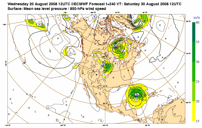
12z EURO loves this system, huge hurricane south of Cuba in 240 hours:
0 likes
Who is online
Users browsing this forum: No registered users and 180 guests