Perturbed Area over Lesser Antilles (Is Invest 93L)

This is the general tropical discussion area. Anyone can take their shot at predicting a storms path.

Moderator: S2k Moderators

Forum rules

The posts in this forum are NOT official forecasts and should not be used as such. They are just the opinion of the poster and may or may not be backed by sound meteorological data. They are NOT endorsed by any professional institution or STORM2K. For official information, please refer to products from the National Hurricane Center and National Weather Service.

Help Support Storm2K
Message
Author
User avatar
Gustywind
Category 5
Category 5
Posts: 12334
Joined: Mon Sep 03, 2007 7:29 am
Location: Baie-Mahault, GUADELOUPE

Perturbed Area over Lesser Antilles (Is Invest 93L)

#1 Postby Gustywind » Wed Sep 17, 2008 2:53 pm

http://www.meteo.fr/temps/domtom/antill ... Tagant.jpg
The" little "wave that we were tracking recently in the Central Atlantic has grown a bit :
TROPICAL WEATHER DISCUSSION
NWS TPC/NATIONAL HURRICANE CENTER MIAMI FL
205 PM EDT WED SEP 17 2008

TROPICAL WEATHER DISCUSSION FOR NORTH AMERICA...CENTRAL
AMERICA...GULF OF MEXICO...CARIBBEAN SEA...NORTHERN SECTIONS
OF SOUTH AMERICA...AND ATLANTIC OCEAN TO THE AFRICAN COAST
FROM THE EQUATOR TO 32N. THE FOLLOWING INFORMATION IS BASED
ON SATELLITE IMAGERY...METEOROLOGICAL ANALYSIS...WEATHER
OBSERVATIONS...AND RADAR.

BASED ON 1200 UTC SURFACE ANALYSIS AND SATELLITE IMAGERY THROUGH
1715 UTC.

...TROPICAL WAVES...
"TROPICAL WAVE IS IN THE E CARIBBEAN ALONG 64W S OF 20N MOVING W 10 KT. ISOLATED SHOWERS ARE OCCURRING IN AN AREA WITHIN 150 NM EAST OF THE WAVE AXIS NORTH OF 11N. RECENT VISIBLE SATELLITE IMAGERY INDICATES THE DEVELOPMENT OF A LOW LEVEL CIRCULATION JUST N OF THE WAVE...WHERE MODERATE CONVECTION IS FROM 22N-25N BETWEEN 62W-65W."...seems organizing just a bit this afternoon, but this has been sufficient for the Pro Met of Meteo-France based on Martinica to issue an yellow alert at 12 AM this morning.
Martinica should begin to experienced strong showers added to thunderstorms tommorow morning and this could persist throught the end of the week ( not good news) and bringing numerous floodings and maybe muslides in some areas....
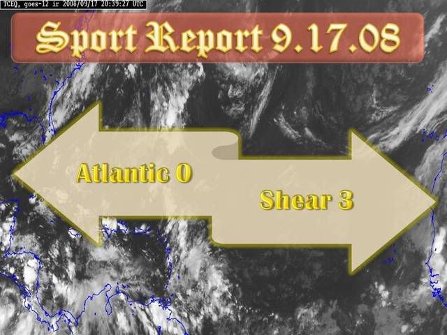
Whereas no TD is anticipated by Martinica's Pro Met, and thus, with my untrained eyes :cheesy: i'm a little dubtfull about a smell of TD given the shear map, conditions are pretty hostile (shear just near the Leewards and Northern Windwards) for something decent (TD or more).. But as usual, we should islanders continue to monitor this area as we're in the peak[/color[color=#FF0000]], don't let your guard down,we never know... :roll: :).
Stay tuned.
Gustywind :)
http://cimss.ssec.wisc.edu/tropic/real- ... g8shr.html
http://cimss.ssec.wisc.edu/tropic/real- ... g8sht.html
0 likes   

User avatar
gatorcane
S2K Supporter
S2K Supporter
Posts: 23499
Age: 46
Joined: Sun Mar 13, 2005 3:54 pm
Location: Boca Raton, FL

Re: Little Perturbed Area east of Martinica trying to organize?

#2 Postby gatorcane » Wed Sep 17, 2008 3:23 pm

I guess its possible....bear watch for this area?

Image
0 likes   

User avatar
Gustywind
Category 5
Category 5
Posts: 12334
Joined: Mon Sep 03, 2007 7:29 am
Location: Baie-Mahault, GUADELOUPE

#3 Postby Gustywind » Wed Sep 17, 2008 3:25 pm

http://www.meteo.fr/temps/domtom/antill ... Tagant.jpg
Numerous patches of convection are doting the area right now, whereas unstelled conditions should occur during the next 24 H... :roll:( should the shear do not sweep it first)! :eek:
0 likes   

User avatar
Gustywind
Category 5
Category 5
Posts: 12334
Joined: Mon Sep 03, 2007 7:29 am
Location: Baie-Mahault, GUADELOUPE

Re: Little Perturbed Area east of Martinica trying to organize?

#4 Postby Gustywind » Wed Sep 17, 2008 3:29 pm

gatorcane wrote:I guess its possible....bear watch for this area?

Image

Absolutely Gatorcane, it's a bear watch as i was talking to you Monday " i will stay more prudent" :cheesy: Remember Gatorcane :cheesy: "For my part i will stay more prudent and wait to say that if it will go poof like 91L. We're in the peak and in..September, us in the islands should not never let our guard down, i don't like to see waves popping and afterwards churning near the Leewards at this period... "..
BEAR WATCH :eek: :eek: islanders....
0 likes   

User avatar
cycloneye
Admin
Admin
Posts: 139596
Age: 67
Joined: Thu Oct 10, 2002 10:54 am
Location: San Juan, Puerto Rico

Re: Little Perturbed Area east of Martinica trying to organize?

#5 Postby cycloneye » Wed Sep 17, 2008 3:41 pm

Image
0 likes   

User avatar
Gustywind
Category 5
Category 5
Posts: 12334
Joined: Mon Sep 03, 2007 7:29 am
Location: Baie-Mahault, GUADELOUPE

Re: Little Perturbed Area east of Martinica trying to organize?

#6 Postby Gustywind » Wed Sep 17, 2008 3:47 pm

cycloneye wrote:Image

:lol: :D you don't waste your time Luis :cheesy: hope just nice amount here and no more... :spam:
0 likes   

User avatar
knotimpaired
Category 1
Category 1
Posts: 495
Joined: Fri May 20, 2005 4:14 am
Location: Vieques, PR
Contact:

#7 Postby knotimpaired » Wed Sep 17, 2008 3:50 pm

LOL Luis. You are good!
0 likes   

User avatar
HURAKAN
Professional-Met
Professional-Met
Posts: 46086
Age: 37
Joined: Thu May 20, 2004 4:34 pm
Location: Key West, FL
Contact:

Re: Little Perturbed Area east of Martinica trying to organize?

#8 Postby HURAKAN » Wed Sep 17, 2008 3:55 pm

Based on the current shear:

Image

Therefore, a more accurate depiction:

Image

Bars = shear
0 likes   

User avatar
gatorcane
S2K Supporter
S2K Supporter
Posts: 23499
Age: 46
Joined: Sun Mar 13, 2005 3:54 pm
Location: Boca Raton, FL

Re: Little Perturbed Area east of Martinica trying to organize?

#9 Postby gatorcane » Wed Sep 17, 2008 4:00 pm

cycloneye wrote:Image


BEARS officially activated :D
0 likes   

User avatar
Gustywind
Category 5
Category 5
Posts: 12334
Joined: Mon Sep 03, 2007 7:29 am
Location: Baie-Mahault, GUADELOUPE

Re:

#10 Postby Gustywind » Wed Sep 17, 2008 4:12 pm

knotimpaired wrote:LOL Luis. You are good!

LOL si si uno de nos talentos de la casa por favor...Cycloneye :wink: :) .
More seriously, our Pro Met of Guadeloupe and St Marteen and St Barth have issued an yellow alert too at 5PM today :eek: for a similar risk like Martinica: risk of strong showers added to thunderstorms....
The latest weather forecast of Martinica is speaking about amounts near 40 to 60 millimeters and more...
Guadeloupe should experience the same with gustywinds ( not me LOL :lol: maybe my cousins :cheesy: ) near 33 kts during some strong during some strong squalls. This rainy episode should stall during at least 48h.
St Marteen and St Barth are in the same forward angle.
BEAR WATCHING :roll: :wink:
0 likes   

User avatar
HURAKAN
Professional-Met
Professional-Met
Posts: 46086
Age: 37
Joined: Thu May 20, 2004 4:34 pm
Location: Key West, FL
Contact:

#11 Postby HURAKAN » Wed Sep 17, 2008 4:14 pm

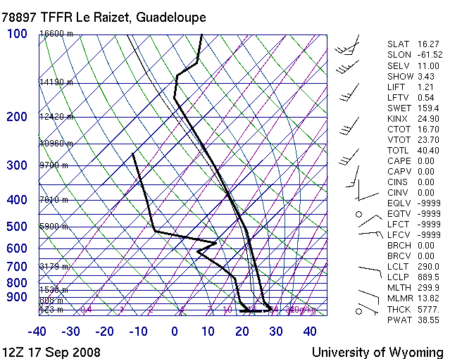
I don't want to be a party pooper but before anyone gets excited, look at the upper levels. There is a trough dropping from Hispaniola to the Lesser Antilles. This area is in the ascending part of the trough and that's why convection is being generated.

Look at the loop and click on HDW-high

Loop: http://www.ssd.noaa.gov/goes/east/carb/loop-avn.html

Image

The Skew-T says everything.
0 likes   

User avatar
Gustywind
Category 5
Category 5
Posts: 12334
Joined: Mon Sep 03, 2007 7:29 am
Location: Baie-Mahault, GUADELOUPE

Re:

#12 Postby Gustywind » Wed Sep 17, 2008 4:19 pm

HURAKAN wrote:I don't want to be a party pooper but before anyone gets excited, look at the upper levels. There is a trough dropping from Hispaniola to the Lesser Antilles. This area is in the ascending part of the trough and that's why convection is being generated.
Absolulety my friend Hurakan :)
Look at the loop and click on HDW-high

Loop: http://www.ssd.noaa.gov/goes/east/carb/loop-avn.html

Absolulety my friend Hurakan :)

000
FXCA62 TJSJ 172019
AFDSJU

AREA FORECAST DISCUSSION
NATIONAL WEATHER SERVICE SAN JUAN PR
419 PM AST WED SEP 17 2008

.DISCUSSION...A WEAK CIRCULATION...VISIBLE IN SATELLITE IMAGERY
TO THE NORTH OF THE LOCAL ISLANDS...IS ASSOCIATED WITH A TROPICAL
WAVE CURRENTLY APPROACHING THE U.S. VIRGIN ISLANDS. EXPECT DEEPER
MOISTURE TO SPREAD ACROSS THE FORECAST AREA BEHIND THE AXIS OF
THIS WAVE ON THURSDAY...WITH ANOTHER ROUND OF DIURNAL CONVECTION
EXPECTED TO DEVELOP OVER THE INTERIOR OF PUERTO RICO AGAIN
TOMORROW AFTERNOON. THE BEST MOISTURE...AND ASSOCIATED DYNAMICS
WITH AN UPPER LEVEL LOW OVER THE ISLANDS...WILL LIKELY BRING A
FURTHER INCREASE IN SHOWER ACTIVITY ACROSS THE AREA ON FRIDAY. THE
LATEST GFS THEN INDICATES FAIRLY DEEP MOISTURE LINGERING ACROSS
THE LOCAL REGION THROUGH MUCH OF NEXT WEEK...WITH A TUTT LOW TO
THE NORTHWEST OF THE LOCAL ISLANDS...WHICH WILL LIKELY RESULT IN
ACTIVE...MAINLY DIURNALLY INDUCED CONVECTION...EXPECTED ACROSS THE
LOCAL ISLANDS THROUGH MUCH OF NEXT WEEK IF THIS SCENARIO PANS OUT.
:eek: :(
0 likes   

Sanibel
Category 5
Category 5
Posts: 10348
Joined: Mon Aug 30, 2004 11:06 pm
Location: Offshore SW Florida

Re: Little Perturbed Area east of Martinica trying to organize?

#13 Postby Sanibel » Wed Sep 17, 2008 4:24 pm

Looks like it is trying to form but too weak.
0 likes   

User avatar
HURAKAN
Professional-Met
Professional-Met
Posts: 46086
Age: 37
Joined: Thu May 20, 2004 4:34 pm
Location: Key West, FL
Contact:

#14 Postby HURAKAN » Wed Sep 17, 2008 4:41 pm

Image

3 because of the domination from coast to coast!
0 likes   

User avatar
Gustywind
Category 5
Category 5
Posts: 12334
Joined: Mon Sep 03, 2007 7:29 am
Location: Baie-Mahault, GUADELOUPE

#15 Postby Gustywind » Wed Sep 17, 2008 5:44 pm

0 likes   

fasterdisaster
Category 5
Category 5
Posts: 1868
Joined: Mon Sep 19, 2005 4:41 pm
Location: Miami, Florida

#16 Postby fasterdisaster » Wed Sep 17, 2008 5:50 pm

EDIT: Sorry gustywind
Last edited by fasterdisaster on Wed Sep 17, 2008 6:04 pm, edited 1 time in total.
0 likes   

User avatar
Fego
S2K Supporter
S2K Supporter
Posts: 767
Age: 64
Joined: Sun Apr 18, 2004 7:58 pm
Location: San Juan, Puerto Rico
Contact:

Re:

#17 Postby Fego » Wed Sep 17, 2008 6:00 pm

fasterdisaster wrote:WTF is Martinica? Is it some weird lovechild of Martinique and Dominica's forbidden love?


With all respect, Martinica is the name in spanish.
0 likes   

fasterdisaster
Category 5
Category 5
Posts: 1868
Joined: Mon Sep 19, 2005 4:41 pm
Location: Miami, Florida

Re: Re:

#18 Postby fasterdisaster » Wed Sep 17, 2008 6:03 pm

Fego wrote:
fasterdisaster wrote:WTF is Martinica? Is it some weird lovechild of Martinique and Dominica's forbidden love?


With all respect, Martinica is the name in spanish.

d'oh :lol:
0 likes   

Steve H.
Category 5
Category 5
Posts: 2134
Joined: Sat Oct 19, 2002 9:06 am
Location: Palm Bay, Florida

Re: Little Perturbed Area east of Martinica trying to organize?

#19 Postby Steve H. » Wed Sep 17, 2008 6:49 pm

But Hurakan, by next week the shear will subside and the mjo pulse will be on the rise. Once the shear drops off we will get back to an active period. I see at least 6 more named storms before the end of the season. And likely 2 of them will be intense.
0 likes   

User avatar
HURAKAN
Professional-Met
Professional-Met
Posts: 46086
Age: 37
Joined: Thu May 20, 2004 4:34 pm
Location: Key West, FL
Contact:

#20 Postby HURAKAN » Wed Sep 17, 2008 6:59 pm

Steve, I'm not saying anything about next week.
0 likes   


Return to “Talkin' Tropics”

Who is online

Users browsing this forum: Brent, cainjamin, Camerooski, chaser1, Cpv17, gatorcane, Google Adsense [Bot], grannyboo, LarryWx, South Texas Storms, Wampadawg, weatherSnoop and 110 guests