Pouch P10L SW of Cape Verde islands (Is invest 99L)

This is the general tropical discussion area. Anyone can take their shot at predicting a storms path.

Moderator: S2k Moderators

Forum rules

The posts in this forum are NOT official forecasts and should not be used as such. They are just the opinion of the poster and may or may not be backed by sound meteorological data. They are NOT endorsed by any professional institution or STORM2K. For official information, please refer to products from the National Hurricane Center and National Weather Service.

Help Support Storm2K
Message
Author
User avatar
cycloneye
Admin
Admin
Posts: 145251
Age: 68
Joined: Thu Oct 10, 2002 10:54 am
Location: San Juan, Puerto Rico

Pouch P10L SW of Cape Verde islands (Is invest 99L)

#1 Postby cycloneye » Sat Jul 28, 2012 1:36 pm

This may be the one many of the global models have some development down the road. The predict team made the first analysis of this pouch on the 28th of July at 00:00 UTC. That means the position on next analysis may be moved a bit to the west. Let's see what occurs as time goes by. Those who may post graphics of the model runs can do so in this thread instead of the "Global Model Runs Discussion Thread".

Image

Image

http://www.met.nps.edu/~mtmontgo/storms2012/P09L.html

SYNOPSIS 2012072800

* Still working on GFS computer issues.

P09L
10N, 4W
700 hPa


ECMWF: Phase speed is based upon v700 during days 3-5. Uncertain positions as I track a tiny OW max within the monsoon trough over West Africa for the first 48 hours. As soon as it moves over the ocean, though, a distinct pouch is depicted fairly quickly that continues to move westward.

GFS:

UKMET: Several uncertain positions when depicted as only an OW max. When it moves out over the Atlantic, P09L is simply a zonally-elongated ITCZ circulation that doesn't move westward, at least not quickly. I stop tracking at that point at 72 hours.

NOGAPS: NOGAPS does actually have an OW max in the same area, and it moves westward out over the ocean, where it stalls. Eventually, a pouch with a CL-trough intersection is also depicted there at day 4 that starts to move slowly westward. So, although slower than ECMWF, NOGAPS has about the same story. However, I don't track anything because four days is too long for me to assign uncertain positions based only upon an OW max. Note that I had to use the v850 Hovmoller to find some sort of signal.

0 likes   
Visit the Caribbean-Central America Weather Thread where you can find at first post web cams,radars
and observations from Caribbean basin members Click Here

User avatar
cycloneye
Admin
Admin
Posts: 145251
Age: 68
Joined: Thu Oct 10, 2002 10:54 am
Location: San Juan, Puerto Rico

Re: Pouch 09L (SE of Cape Verde Islands)

#2 Postby cycloneye » Sat Jul 28, 2012 4:02 pm

It now has a low added on the 18z Surface Analysis.

Image
0 likes   
Visit the Caribbean-Central America Weather Thread where you can find at first post web cams,radars
and observations from Caribbean basin members Click Here

User avatar
cycloneye
Admin
Admin
Posts: 145251
Age: 68
Joined: Thu Oct 10, 2002 10:54 am
Location: San Juan, Puerto Rico

Re: Pouch 09L in Eastern Atlantic

#3 Postby cycloneye » Sat Jul 28, 2012 7:01 pm

8:05 PM EDT discussion referring to low pressure.

TROPICAL WEATHER DISCUSSION
NWS NATIONAL HURRICANE CENTER MIAMI FL
805 PM EDT SAT JUL 28 2012

...ITCZ/MONSOON TROUGH...

THE MONSOON TROUGH EXTENDS ACROSS W AFRICA TO THE COAST OF
SENEGAL AT 14N17W CONTINUING ACROSS ATLC WATERS THROUGH A 1011
MB SURFACE LOW AT 9N26W
TO 11N39W 12N47W.
SCATTERED MODERATE / ISOLATED STRONG CONVECTION IS AROUND THE CIRCULATION OF
THE SURFACE LOW
FROM 7N-10N BETWEEN 18W-27W...AND FROM 7N-12N
BETWEEN 27W-35W.
0 likes   
Visit the Caribbean-Central America Weather Thread where you can find at first post web cams,radars
and observations from Caribbean basin members Click Here

User avatar
Rgv20
S2K Supporter
S2K Supporter
Posts: 2466
Age: 38
Joined: Wed Jan 05, 2011 5:42 pm
Location: Edinburg/McAllen Tx

#4 Postby Rgv20 » Sun Jul 29, 2012 2:24 am

The 0zruns of the CMC, UKMET, and GFS are trying to hint that this wave may try to develop as early as in 5 days.

0zCMC forecast valid for Thursday Evening has a low pressure system east of the Antilles.....Keep in mind that the CMC almost always overestimates Tropical Cyclones.
Image

0zUKMET also has a low pressure system in the same time frame as the CMC. The GFS is slower with this wave by about 24 hours.
Image
0 likes   
The following post is NOT an official forecast and should not be used as such. It is just the opinion of the poster and may or may not be backed by sound meteorological data. It is NOT endorsed by any professional institution including storm2k.org For Official Information please refer to the NHC and NWS products.

User avatar
Gustywind
Category 5
Category 5
Posts: 12334
Joined: Mon Sep 03, 2007 7:29 am
Location: Baie-Mahault, GUADELOUPE

#5 Postby Gustywind » Sun Jul 29, 2012 4:55 am

000
AXNT20 KNHC 290603
TWDAT

TROPICAL WEATHER DISCUSSION
NWS NATIONAL HURRICANE CENTER MIAMI FL
205 AM EDT SUN JUL 29 2012

...THE ITCZ/THE MONSOON TROUGH...

THE MONSOON TROUGH PASSES THROUGH COASTAL SENEGAL NEAR 14N17W
TO 11N25W TO A 1012 MB LOW PRESSURE CENTER THAT IS NEAR 10N31W.
THE MONSOON TROUGH CONTINUES FROM 10N31W TO 9N36W 12N45W AND
11N53W. CONVECTIVE PRECIPITATION...NUMEROUS STRONG FROM 8N TO
10N BETWEEN 13W AND 15W AND FROM 9N TO 11N BETWEEN 33W AND
34W...WIDELY SCATTERED MODERATE TO ISOLATED STRONG ELSEWHERE
FROM 7N TO 12N BETWEEN AFRICA AND 60W.
0 likes   

User avatar
cycloneye
Admin
Admin
Posts: 145251
Age: 68
Joined: Thu Oct 10, 2002 10:54 am
Location: San Juan, Puerto Rico

Re: Pouch 09L in Eastern Atlantic

#6 Postby cycloneye » Sun Jul 29, 2012 8:42 am

:think: I am a little bit confused in terms of the true location of the pouch as no wave has been introduced yet. That weak low is well west of the pouch analized by the predict team. But the sure location in terms of the area in general is somewhere in Eastern Atlantic :)
0 likes   
Visit the Caribbean-Central America Weather Thread where you can find at first post web cams,radars
and observations from Caribbean basin members Click Here

User avatar
cycloneye
Admin
Admin
Posts: 145251
Age: 68
Joined: Thu Oct 10, 2002 10:54 am
Location: San Juan, Puerto Rico

Re: Pouch 09L in Eastern Atlantic

#7 Postby cycloneye » Sun Jul 29, 2012 9:57 am

Still no Tropical Wave introduced on the 12z TAFB Surface Analysis. Weak Low is mantained at 10N-30W.

Image
0 likes   
Visit the Caribbean-Central America Weather Thread where you can find at first post web cams,radars
and observations from Caribbean basin members Click Here

User avatar
Rgv20
S2K Supporter
S2K Supporter
Posts: 2466
Age: 38
Joined: Wed Jan 05, 2011 5:42 pm
Location: Edinburg/McAllen Tx

#8 Postby Rgv20 » Sun Jul 29, 2012 11:54 am

12zGFS showing a weak low by Friday evening east of the Antilles.

Image
0 likes   
The following post is NOT an official forecast and should not be used as such. It is just the opinion of the poster and may or may not be backed by sound meteorological data. It is NOT endorsed by any professional institution including storm2k.org For Official Information please refer to the NHC and NWS products.

User avatar
cycloneye
Admin
Admin
Posts: 145251
Age: 68
Joined: Thu Oct 10, 2002 10:54 am
Location: San Juan, Puerto Rico

Re:

#9 Postby cycloneye » Sun Jul 29, 2012 11:56 am

Rgv20 wrote:12zGFS showing a weak low by Friday evening east of the Antilles.

http://i61.photobucket.com/albums/h62/c ... cal132.gif


That massive High Pressure is what keeps it low in latitude in that model.Other models I have seen has it more north. I wonder if the EURO is going to join the development bandwagon soon.
0 likes   
Visit the Caribbean-Central America Weather Thread where you can find at first post web cams,radars
and observations from Caribbean basin members Click Here

User avatar
cycloneye
Admin
Admin
Posts: 145251
Age: 68
Joined: Thu Oct 10, 2002 10:54 am
Location: San Juan, Puerto Rico

Re: Pouch 09L in Eastern Atlantic

#10 Postby cycloneye » Sun Jul 29, 2012 12:02 pm

Image

Image
0 likes   
Visit the Caribbean-Central America Weather Thread where you can find at first post web cams,radars
and observations from Caribbean basin members Click Here

User avatar
cycloneye
Admin
Admin
Posts: 145251
Age: 68
Joined: Thu Oct 10, 2002 10:54 am
Location: San Juan, Puerto Rico

Re: Pouch 09L in Eastern Atlantic

#11 Postby cycloneye » Sun Jul 29, 2012 12:15 pm

12z CMC goes just north of Leewards.

Image
0 likes   
Visit the Caribbean-Central America Weather Thread where you can find at first post web cams,radars
and observations from Caribbean basin members Click Here

User avatar
Nimbus
Category 5
Category 5
Posts: 5300
Joined: Mon Jul 19, 2004 10:54 am

#12 Postby Nimbus » Sun Jul 29, 2012 12:55 pm

Looks like it is converging near 35W 9 - 11 N. There is more available moisture for this one and ridging to the north at least through 50W or so.

I don't think we will see explosive development so it might not be a fish/Bermuda storm.
0 likes   

User avatar
cycloneye
Admin
Admin
Posts: 145251
Age: 68
Joined: Thu Oct 10, 2002 10:54 am
Location: San Juan, Puerto Rico

Re: Pouch 09L in Eastern Atlantic

#13 Postby cycloneye » Sun Jul 29, 2012 1:42 pm

12z ECMWF is in agreement with GFS on track and strengh.

Image
0 likes   
Visit the Caribbean-Central America Weather Thread where you can find at first post web cams,radars
and observations from Caribbean basin members Click Here

User avatar
cycloneye
Admin
Admin
Posts: 145251
Age: 68
Joined: Thu Oct 10, 2002 10:54 am
Location: San Juan, Puerto Rico

Re: Pouch 09L in Eastern Atlantic

#14 Postby cycloneye » Sun Jul 29, 2012 1:51 pm

An excerpt from Marine discussion.

MARINE WEATHER DISCUSSION
NWS NATIONAL HURRICANE CENTER MIAMI FL
200 PM EDT SUN JUL 29 2012

A LOW PRES IS CURRENTLY EMBEDDED IN
ITCZ NEAR 10N30W. CONSENSUS GUIDANCE HANGS ON TO THIS FEATURE
WITH THE GFS THE MOST AGGRESSIVE. ADJUSTED THE WINDS AND
ASSOCIATED SEAS DOWN TO MAX AT 25 KT NE SEMICIRCLE ON THE
EXTENDED GRIDS. LOW CONFIDENCE COORDINATED MEDIUM RANGE 12Z
POSITIONS ARE 10.5N43W WED... 10.548.5W THU...11.5N54W
FRI...12.5N60W SAT...AND 13N65.5W SUN.
0 likes   
Visit the Caribbean-Central America Weather Thread where you can find at first post web cams,radars
and observations from Caribbean basin members Click Here

User avatar
cycloneye
Admin
Admin
Posts: 145251
Age: 68
Joined: Thu Oct 10, 2002 10:54 am
Location: San Juan, Puerto Rico

Re: Pouch 09L in Eastern Atlantic

#15 Postby cycloneye » Sun Jul 29, 2012 2:35 pm

The somewhat confusing position of this pouch has been resolved as this is now P10L and the one emerging West Africa is P09L. :) Who wants to create a thread for P09L?

This analysis by the predict team was made last night at 00z.

P10L
9N, 25W
700 hPa

Within the ITCZ/MT just off the West African coast, yesterday I started monitoring an area of circulation close to the coast (P09L). Meanwhile, during the last day, another area farther offshore has spun up, and appears even more pronounced in the CIMSS TPW loop and NRL satellite imagery. The models have picked up on it (in varying amounts, of course), so I initiate P10L, to the west of P09L. (This ITCZ/MT region can drive me bonkers!)

Level determination: UKMET is very strong, with a pouch at all levels, including 700 hPa. Although a lower level may produce a few more positions in the other models, I will track at 700 hPa so that I am tracking all three pouches (P07L, P09L, P10L) at the same level.


ECMWF: Very weak v700 Hovmoller signal, and not surprisingly, P10L only lasts to 24 hours. Tiny ITCZ/MT pouch. ECMWF favors P09L, which UKMET favors P10L.

GFS:

UKMET: Very strong at all levels. Moves steadily westward, with increasing OW.

NOGAPS: Only an OW max during the first day, but eventually, two OW max are depicted. I track the eastern one as P09L and the western one as P10L, which strengthens.

http://www.met.nps.edu/~mtmontgo/storms2012/P10L.html
0 likes   
Visit the Caribbean-Central America Weather Thread where you can find at first post web cams,radars
and observations from Caribbean basin members Click Here

User avatar
Rgv20
S2K Supporter
S2K Supporter
Posts: 2466
Age: 38
Joined: Wed Jan 05, 2011 5:42 pm
Location: Edinburg/McAllen Tx

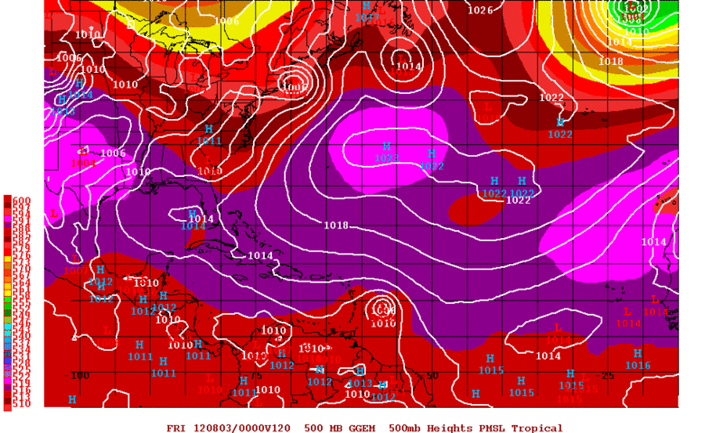
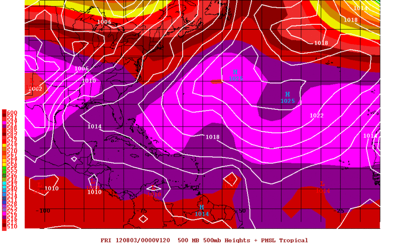
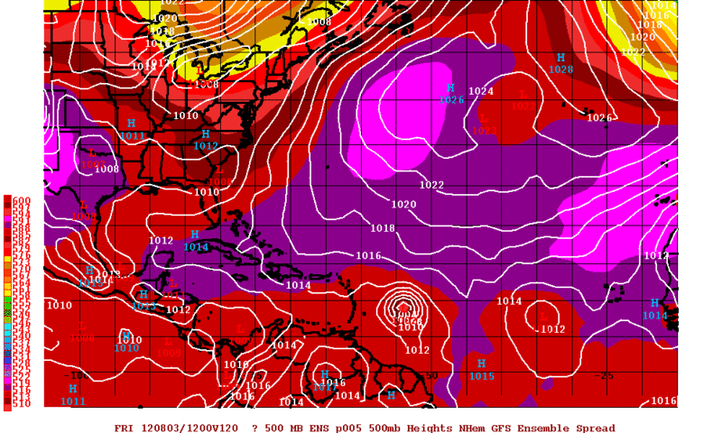
#16 Postby Rgv20 » Sun Jul 29, 2012 3:11 pm

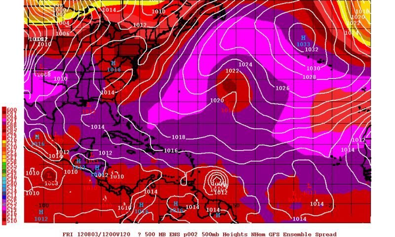
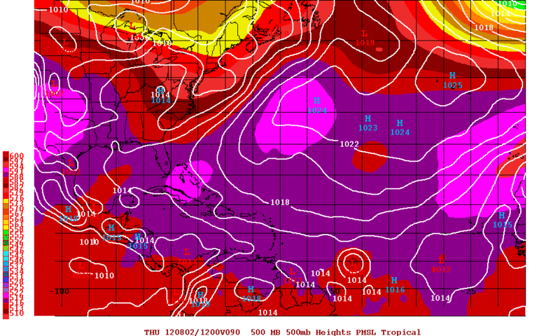
Here are 2 12zGFS Ensemble Members and they certainly like this wave.....Going to be interesting to see how this unfolds!

Forecast Valid for Friday Morning
Image

Image
0 likes   
The following post is NOT an official forecast and should not be used as such. It is just the opinion of the poster and may or may not be backed by sound meteorological data. It is NOT endorsed by any professional institution including storm2k.org For Official Information please refer to the NHC and NWS products.

User avatar
Riptide
Category 2
Category 2
Posts: 753
Age: 33
Joined: Fri Jul 23, 2010 3:33 pm
Location: Cape May, New Jersey
Contact:

Re: Pouch P10L SW of Cape Verde islands

#17 Postby Riptide » Sun Jul 29, 2012 3:51 pm

I'm confused about the setup in the MDR because I do not see two distinct tropical waves, only scattered ITCZ convection. It appears the GFS and euro are developing the system emerging from Africa, looks likely that at least one of these areas will develop.
0 likes   

User avatar
cycloneye
Admin
Admin
Posts: 145251
Age: 68
Joined: Thu Oct 10, 2002 10:54 am
Location: San Juan, Puerto Rico

Re: Pouch P10L SW of Cape Verde islands

#18 Postby cycloneye » Sun Jul 29, 2012 3:54 pm

18z TAFB Surface Analysis.

Image
0 likes   
Visit the Caribbean-Central America Weather Thread where you can find at first post web cams,radars
and observations from Caribbean basin members Click Here

User avatar
weatherwindow
Category 4
Category 4
Posts: 904
Joined: Mon Sep 20, 2004 9:48 am
Location: key west/ft lauderdale

Re: Pouch P10L SW of Cape Verde islands

#19 Postby weatherwindow » Sun Jul 29, 2012 5:39 pm

speaking of liking this pouch(10P), the 00Z GFS is fairly enamoured with it.....08/06 middling TS thru Tobago/southern Windwards...moves wnw thru the central Caribbean as a weak TS..08/09 weakens crossing Jamaica and east central Cuba...08/10 reforms in the Old Bahama Channel...08/10 and 08/11 strengthens rapidly in the Florida Straits, approaching south Florida on a northwesterly course...08/11 landfall south Miami-Dade/extreme north Monroe counties(extreme south Florida) as a moderate and strengthening TS...08/12 building ridge forces a turn to the west or west-northwest and exits the peninsula near Tampa...08/12-08/14 a strengthening hurricane moving on a west to west-northwest course thru the GOM..08/14 several hundred miles due south of Mobile...rich http://raleighwx.americanwx.com/models/ ... SLoop.html
0 likes   

User avatar
Rgv20
S2K Supporter
S2K Supporter
Posts: 2466
Age: 38
Joined: Wed Jan 05, 2011 5:42 pm
Location: Edinburg/McAllen Tx

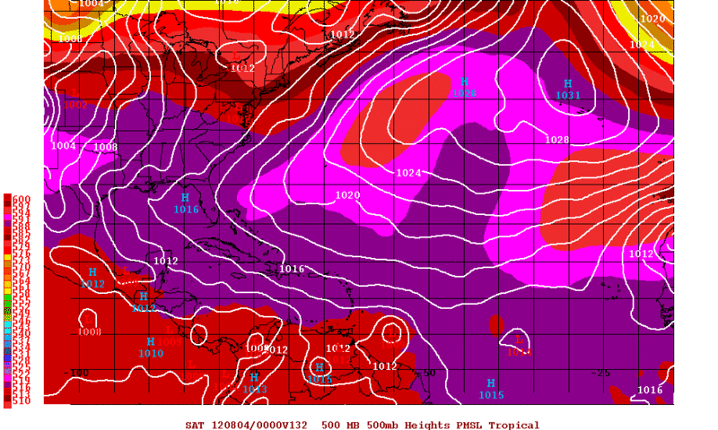
#20 Postby Rgv20 » Sun Jul 29, 2012 6:19 pm

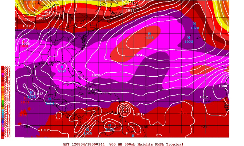
18zGFS continues the trend on developing this wave as early as mid to late week. By Saturday morning it has a well developed TC just east to of the Antilles.

Image

Image
0 likes   
The following post is NOT an official forecast and should not be used as such. It is just the opinion of the poster and may or may not be backed by sound meteorological data. It is NOT endorsed by any professional institution including storm2k.org For Official Information please refer to the NHC and NWS products.


Return to “Talkin' Tropics”

Who is online

Users browsing this forum: Ulf and 36 guests