I honestly don't know what the NWS out New Orleans is referring to as a possible wave developing
into a tropical low in the GOM over the weekend. It can't be 99L.
AREA FORECAST DISCUSSION
NATIONAL WEATHER SERVICE NEW ORLEANS LA
408 PM CDT THU SEP 5 2013
.LONG TERM...
HEADING INTO NEXT WEEK...THE PATTERN WILL BEGIN TO SHIFT AS THE
UPPER LEVEL RIDGE SLIDES TOWARD THE MIDWEST AND A STRONG
TROPICAL WAVE MOVES ACROSS THE WESTERN GULF OF MEXICO TOWARD TEXAS
AND NORTHERN MEXICO. THIS TROPICAL FEATURE MAY DEVELOP INTO A FULL
FLEDGED TROPICAL LOW OVER THE WEEKEND...BUT NO SIGNIFICANT IMPACTS
ARE EXPECTED ACROSS THE FORECAST AREA...DUE TO THE STRONG MID TO
UPPER LEVEL RIDGING DOMINATING THE MISSISSIPPI VALLEY AND GULF
SOUTH. AT MOST...INCREASED SOUTHEASTERLY FLOW AND SLIGHTLY HIGHER
POPS CAN BE EXPECTED DUE TO A WEAKER CAP ALOFT AND DEEPER TROPICAL
MOISTURE FEEDING INTO THE AREA FROM THE SOUTHERN GULF OF MEXICO ON
TUESDAY. TEMPERATURES WILL DROP BACK TO MORE NORMAL LEVELS BY NEXT
WEEK DUE TO THE INCREASED CONVECTION AND HIGHER LOW LEVEL MOISTURE
CONTENT.
THE UPPER LEVEL RIDGE WILL BEGIN TO WEAKEN ON THURSDAY
AND FRIDAY...AND SHIFT TOWARD THE PLAINS STATES...AS ANOTHER SHORT
WAVE TROUGH AND ASSOCIATED FRONTAL BOUNDARY SLIDE THROUGH THE
MIDWEST. A WEAK FRONTAL BOUNDARY WILL SLIDE TOWARD THE AREA FOR
THURSDAY AND FRIDAY...FURTHER INCREASING RAIN CHANCES FOR THE
LATTER HALF OF THE WEEK.
Development in SW Gulf or Bay of Campeche: (Is Invest 93L)
Moderator: S2k Moderators
Forum rules

The posts in this forum are NOT official forecasts and should not be used as such. They are just the opinion of the poster and may or may not be backed by sound meteorological data. They are NOT endorsed by any professional institution or STORM2K. For official information, please refer to products from the National Hurricane Center and National Weather Service.
-
Stormcenter
- S2K Supporter

- Posts: 6689
- Joined: Wed Sep 03, 2003 11:27 am
- Location: Houston, TX

-
gatorcane

- S2K Supporter
- Posts: 23708
- Age: 48
- Joined: Sun Mar 13, 2005 3:54 pm
- Location: Boca Raton, FL
The tropical wave they are talking about is located in the Western Caribbean.. See image below:

The 12Z ECMWF brings some energy into Southern Texas from this wave 96 hours from 12Z today (orange area in image):

There is currently no model support for this feature developing into a tropical cyclone this weekend in the Gulf.
The 12Z ECMWF brings some energy into Southern Texas from this wave 96 hours from 12Z today (orange area in image):
There is currently no model support for this feature developing into a tropical cyclone this weekend in the Gulf.
0 likes
-
Portastorm

- Storm2k Moderator

- Posts: 9955
- Age: 63
- Joined: Fri Jul 11, 2003 9:16 am
- Location: Round Rock, TX
- Contact:
Re: Development in GOM this weekend?
Stormcenter, there is a lot of chatter out there especially in private met circles that the Western GOM is the going to be a very active/moist area in the next two weeks.
0 likes
Any forecasts under my name are to be taken with a grain of salt. Get your best forecasts from the National Weather Service and National Hurricane Center.
-
CrazyC83
- Professional-Met

- Posts: 34316
- Joined: Tue Mar 07, 2006 11:57 pm
- Location: Deep South, for the first time!
Re: Development in GOM this weekend?
Portastorm wrote:Stormcenter, there is a lot of chatter out there especially in private met circles that the Western GOM is the going to be a very active/moist area in the next two weeks.
Makes sense, as long as a trigger can be found - and it will be difficult to get tropical waves there as long as they keep drying out and shearing to death in the MDR...but if a cold front or trough can die out over the Gulf, then we might be in action...
0 likes
-
tolakram
- Admin

- Posts: 20186
- Age: 62
- Joined: Sun Aug 27, 2006 8:23 pm
- Location: Florence, KY (name is Mark)
Re: Development in GOM this weekend?
http://www.tropicaltidbits.com/analysis/models/gfs/2013090606/gfs_vort850_uv200_atltropics.html
If you step through the vorticity loop from the 6Z GFS you can see multiple areas of vorticity in the western gulf.
If you step through the vorticity loop from the 6Z GFS you can see multiple areas of vorticity in the western gulf.
0 likes
M a r k
- - - - -
Join us in chat: Storm2K Chatroom Invite. Android and IOS apps also available.
The posts in this forum are NOT official forecasts and should not be used as such. Posts are NOT endorsed by any professional institution or STORM2K.org. For official information and forecasts, please refer to NHC and NWS products.
-
wxman57

- Moderator-Pro Met

- Posts: 23175
- Age: 68
- Joined: Sat Jun 21, 2003 8:06 pm
- Location: Houston, TX (southwest)
Re: Development in GOM this weekend?
Portastorm wrote:Stormcenter, there is a lot of chatter out there especially in private met circles that the Western GOM is the going to be a very active/moist area in the next two weeks.
Yes, I've been chattering. No model projections of development in the Gulf but lots of available moisture there over the coming weeks. Needs to be watched for close-in development. Not this weekend, though, I'm enjoying another one off...
0 likes
-
Hurricaneman

- Category 5

- Posts: 7404
- Age: 45
- Joined: Tue Aug 31, 2004 3:24 pm
- Location: central florida
Re:
Alyono wrote:GFS consistently showing what looks to be a TS in the BOC next week
I must say that area needs to be watched again, but it would probably landfall between Veracruz and Tampico like they have all season
The posts in this forum are NOT official forecast and should not be used as such. They are just the opinion of the poster and may or may not be backed by sound meteorological data. They are NOT endorsed by any professional institution or storm2k.org. For official information, please refer to the NHC and NWS products
0 likes
-
Florida1118
Re: Development in GOM this weekend?
Hurricaneman wrote:Alyono wrote:GFS consistently showing what looks to be a TS in the BOC next week
I must say that area needs to be watched again, but it would probably landfall between Veracruz and Tampico like they have all season
The posts in this forum are NOT official forecast and should not be used as such. They are just the opinion of the poster and may or may not be backed by sound meteorological data. They are NOT endorsed by any professional institution or storm2k.org. For official information, please refer to the NHC and NWS products
A TROUGH OF LOW PRESSURE COULD FORM OVER THE EXTREME SOUTHWESTERN
GULF OF MEXICO AND BAY OF CAMPECHE IN A FEW DAYS. SOME DEVELOPMENT
OF THIS SYSTEM IS POSSIBLE BY MIDWEEK. THIS SYSTEM HAS A LOW
CHANCE...NEAR 0 PERCENT...OF BECOMING A TROPICAL CYCLONE DURING THE
NEXT 48 HOURS...AND A LOW CHANCE...20 PERCENT...OF BECOMING A
TROPICAL CYCLONE DURING THE NEXT 5 DAYS.
0 likes
Re: Development in GOM: 0% - 20%
http://wxmaps.org/pix/hurpot.html#ATL
safe to say that heat potential is not a problem.
I wouldnt be to sure a direct path into MX would be a given....
safe to say that heat potential is not a problem.
I wouldnt be to sure a direct path into MX would be a given....
0 likes
-
hurricanes1234
- Category 5
- Posts: 2908
- Joined: Sat Jul 28, 2012 6:19 pm
- Location: Trinidad and Tobago
Re: Development in GOM: 0% - 20%
Does anyone think this would be a hurricane?
Personal Forecast Disclaimer: The posts in this forum are NOT official forecast and should not be used as such. They are just the opinion of the poster and may or may not be backed by sound meteorological data. They are NOT endorsed by any professional institution or storm2k.org. For official information, please refer to the NHC and NWS products.
Personal Forecast Disclaimer: The posts in this forum are NOT official forecast and should not be used as such. They are just the opinion of the poster and may or may not be backed by sound meteorological data. They are NOT endorsed by any professional institution or storm2k.org. For official information, please refer to the NHC and NWS products.
0 likes
PLEASE NOTE: With the exception of information from weather agencies that I may copy and paste here, my posts will NEVER be official, since I am NOT a meteorologist. They are solely my amateur opinion, and may or may not be accurate. Therefore, please DO NOT use them as official details, particularly when making important decisions. Thank you.


Re: Development in GOM: 0% - 20%
hurricanes1234 wrote:Does anyone think this would be a hurricane?
Personal Forecast Disclaimer: The posts in this forum are NOT official forecast and should not be used as such. They are just the opinion of the poster and may or may not be backed by sound meteorological data. They are NOT endorsed by any professional institution or storm2k.org. For official information, please refer to the NHC and NWS products.
Slow down we don't even have a system yet.
0 likes
-
hurricanes1234
- Category 5
- Posts: 2908
- Joined: Sat Jul 28, 2012 6:19 pm
- Location: Trinidad and Tobago
Re: Development in GOM: 0% - 20%
perk wrote:hurricanes1234 wrote:Does anyone think this would be a hurricane?
Personal Forecast Disclaimer: The posts in this forum are NOT official forecast and should not be used as such. They are just the opinion of the poster and may or may not be backed by sound meteorological data. They are NOT endorsed by any professional institution or storm2k.org. For official information, please refer to the NHC and NWS products.
Slow down we don't even have a system yet.
I meant to ask if there was any model support that would bring this to hurricane strength. I always ask these things in advance, so I would at least have an understanding or an idea as to what we could be dealing with.
0 likes
PLEASE NOTE: With the exception of information from weather agencies that I may copy and paste here, my posts will NEVER be official, since I am NOT a meteorologist. They are solely my amateur opinion, and may or may not be accurate. Therefore, please DO NOT use them as official details, particularly when making important decisions. Thank you.
-
wxman57
- Moderator-Pro Met
- Posts: 23175
- Age: 68
- Joined: Sat Jun 21, 2003 8:06 pm
- Location: Houston, TX (southwest)
Re: Development in GOM: 0% - 20%
I think that the Gulf is definitely the place to watch in the next few weeks. There is a ton of moisture in the Gulf now, and we know from 3 developments already in the BoC that conditions are good for development. There's a wave axis that spawned Gabrielle heading west toward the western Caribbean now. That wave could be the spark that starts the next development in the SW Gulf and/or BoC. Question is, will the ridge still be over TX when it forms? If so, then it will head west into Mexico. If not, then it could turn north toward TX or LA. If it has more than a day over water then it would have a good chance of becoming a hurricane.
For now, I wouldn't look east of the Caribbean for threats. Those systems are heading out to sea. Look west!
For now, I wouldn't look east of the Caribbean for threats. Those systems are heading out to sea. Look west!
0 likes
-
Rgv20

- S2K Supporter
- Posts: 2466
- Age: 39
- Joined: Wed Jan 05, 2011 5:42 pm
- Location: Edinburg/McAllen Tx
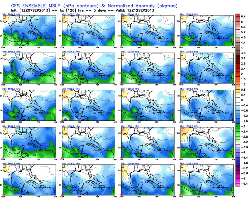
12zGFS Ensemble members mostly in agreement with at least lowering pressures in the SW GOM/BOC area in 5 days.

0 likes
The following post is NOT an official forecast and should not be used as such. It is just the opinion of the poster and may or may not be backed by sound meteorological data. It is NOT endorsed by any professional institution including storm2k.org For Official Information please refer to the NHC and NWS products.
-
Tireman4

- S2K Supporter
- Posts: 5904
- Age: 60
- Joined: Fri Jun 30, 2006 1:08 pm
- Location: Humble, Texas
- Contact:
Re: Development in GOM: 0% - 20%
For now, I wouldn't look east of the Caribbean for threats. Those systems are heading out to sea. Look west!
Is that anything like, "Go West, young man"...LOL. Little bit of history there. I could not resist. LOL.
0 likes
-
CYCLONE MIKE
- Category 5
- Posts: 2183
- Joined: Tue Aug 31, 2004 6:04 pm
- Location: Gonzales, LA
Re: Development in SW Gulf or Bay of Campeche: 0% - 20%
Just not sure the fronts are strong enough yet to displace the Texas ridge further west out into the sw us. Seems to me anything forming that far south into the boc will go west into mexico just like the others have.
0 likes
This post is NOT AN OFFICIAL FORECAST and should not be used as such. It is just the opinion of the poster and may or may not be backed by sound meteorological data. It is NOT endorsed by any professional institution including storm2k.org. For Official Information please refer to the NHC and NWS products.
Who is online
Users browsing this forum: Ulf and 172 guests