

http://www.nrlmry.navy.mil/tc-bin/tc_ho ... rovap/dmsp
Invest 90L is gone from NRL. Continue the discussion here!
Post-90L: Discussions & Imagery: T1.0/1.0
Moderator: S2k Moderators
Forum rules

The posts in this forum are NOT official forecasts and should not be used as such. They are just the opinion of the poster and may or may not be backed by sound meteorological data. They are NOT endorsed by any professional institution or STORM2K. For official information, please refer to products from the National Hurricane Center and National Weather Service.
-
mattpetre
- Category 2

- Posts: 510
- Age: 54
- Joined: Mon Sep 19, 2005 3:20 pm
- Location: Missouri City,TX & Galleria
- Contact:
Depression to form in GOM?? part II
Well, it became 90L and now it's back to the lowly life of a blip in Talkin' Tropics, but GOM/90L you have been called all sorts of names "disorganized mess", "slave to shear", and even dead. I still have a feeling that you have a little life to show and honestly I hope that life brings you to a TS status that heads right towards the FL panhandle, because they need your rain and we here in TX do not! Have a feeling this will be back in the active pages before the day is done, but only time will tell. If not, you were an interesting blob 90L.
0 likes
-
southerngale

- Retired Staff

- Posts: 27418
- Joined: Thu Oct 10, 2002 1:27 am
- Location: Southeast Texas (Beaumont area)

Re: Post-90L: Discussions, Analysis & Imagery
I dont understand why people are saying that this system is destroyed if the invest is taken away from it. It isn't as if the NRL waves a giant wand and causes the system to poof. The NRL and NHC do not decide whether systems develop, they report whether these systems have developed. If this system was on its road to organizing an hour ago, the system isnt going to think "Oh no, I'm not an invest anymore" and vanish.
No disrespect is intended to any posters or the NRL or the NHC.
No disrespect is intended to any posters or the NRL or the NHC.
0 likes
-
Stormcenter
- S2K Supporter

- Posts: 6689
- Joined: Wed Sep 03, 2003 11:27 am
- Location: Houston, TX
Re: Post-90L: Discussions, Analysis & Imagery
BigA wrote:I dont understand why people are saying that this system is destroyed if the invest is taken away from it. It isn't as if the NRL waves a giant wand and causes the system to poof. The NRL and NHC do not decide whether systems develop, they report whether these systems have developed. If this system was on its road to organizing an hour ago, the system isnt going to think "Oh no, I'm not an invest anymore" and vanish.
No disrespect is intended to any posters or the NRL or the NHC.
An Excellent post.
0 likes
-
southerngale
- Retired Staff
- Posts: 27418
- Joined: Thu Oct 10, 2002 1:27 am
- Location: Southeast Texas (Beaumont area)
Re: Post-90L: Discussions, Analysis & Imagery
BigA wrote:I dont understand why people are saying that this system is destroyed if the invest is taken away from it. It isn't as if the NRL waves a giant wand and causes the system to poof. The NRL and NHC do not decide whether systems develop, they report whether these systems have developed. If this system was on its road to organizing an hour ago, the system isnt going to think "Oh no, I'm not an invest anymore" and vanish.
No disrespect is intended to any posters or the NRL or the NHC.
I believe we all know this.
Of course, it could still develop. However, they're clearly not very concerned about it developing, at least in the short term, or they wouldn't have dropped the Invest.
Just as you said it doesn't know it isn't an Invest anymore, it also doesn't know if someone says it is destroyed or poof, or whatever.
0 likes


Re: Post-90L: Discussions, Analysis & Imagery
a tidbit from the Lake Charles AFD late this morn....
AREA FORECAST DISCUSSION
NATIONAL WEATHER SERVICE LAKE CHARLES LA
1035 AM CDT MON SEP 10 2007
THERE IS SOME DEFINITE CYCLONIC TURNING IN THE LOW LEVELS ABOUT
350 MILES SOUTH OF CAMERON. CURRENTLY...THE UPPER LEVEL WINDS
OVER THE NORTHWEST GULF...WHICH IS THE GENERAL DIRECTION THE WAVE
IS HEADED...ARE UNFAVORABLE FOR TROPICAL DEVELOPMENT. THE GFS AND
NAM ARE FORECASTING THIS TO CHANGE OVER THE COURSE OF THE NEXT 24
TO 36 HRS...AND GIVEN THE WAVES SLOW WESTWARD PROGRESS...IT IS NOT
OUT OF THE REALM OF POSSIBILITY THAT FURTHER DEVELOPMENT COULD
TAKE PLACE...THOUGH IT WOULD BE A SLOW PROCESS.
0 likes
-
Stormcenter
- S2K Supporter
- Posts: 6689
- Joined: Wed Sep 03, 2003 11:27 am
- Location: Houston, TX
-
flwxwatcher
- Category 4

- Posts: 926
- Joined: Wed May 16, 2007 3:35 pm
- Location: Central Florida
Re: Post-90L: Discussions, Analysis & Imagery
teal61 wrote:a tidbit from the Lake Charles AFD late this morn....
AREA FORECAST DISCUSSION
NATIONAL WEATHER SERVICE LAKE CHARLES LA
1035 AM CDT MON SEP 10 2007
THERE IS SOME DEFINITE CYCLONIC TURNING IN THE LOW LEVELS ABOUT
350 MILES SOUTH OF CAMERON. CURRENTLY...THE UPPER LEVEL WINDS
OVER THE NORTHWEST GULF...WHICH IS THE GENERAL DIRECTION THE WAVE
IS HEADED...ARE UNFAVORABLE FOR TROPICAL DEVELOPMENT. THE GFS AND
NAM ARE FORECASTING THIS TO CHANGE OVER THE COURSE OF THE NEXT 24
TO 36 HRS...AND GIVEN THE WAVES SLOW WESTWARD PROGRESS...IT IS NOT
OUT OF THE REALM OF POSSIBILITY THAT FURTHER DEVELOPMENT COULD
TAKE PLACE...THOUGH IT WOULD BE A SLOW PROCESS.
Yes, while upper winds right now are unfavorable it looks like according to the GFS that will change in the next day or so. and maybe something can try to get organized.Time will tell
0 likes

Re: Post-90L: Discussions, Analysis & Imagery
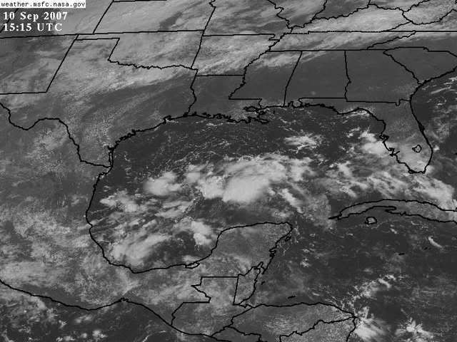
Well, on the SSD SAT there is now a 1011 mb low pressure system where the cyclonic turning is evident near 24N-92W. It appears NRL dropped this prematurely in my opinion.
0 likes
-
mattpetre
- Category 2
- Posts: 510
- Age: 54
- Joined: Mon Sep 19, 2005 3:20 pm
- Location: Missouri City,TX & Galleria
- Contact:
Re: Post-90L: Discussions, Analysis & Imagery
Convection getting stronger in the right spots for development... shear not evident in that mass of blobs...
0 likes

Re: Post-90L: Discussions, Analysis & Imagery
Wind shear in the are looks to be not too high http://cimss.ssec.wisc.edu/tropic/real- ... g8shr.html and trending lower http://cimss.ssec.wisc.edu/tropic/real- ... g8sht.html
0 likes
-
Ed Mahmoud
Re: Post-90L: Discussions, Analysis & Imagery
Former 90L- Just watched the Bastardi video, he admits he thought this would already be a cyclone by now, and he isn't quite as bullish, but with front dropping into Texas bringing Northerly winds to Western GOMEX, and shear relaxing, he says it is still possible. Not big ticket, apparently.
Former 92L- Will be in a favorable area when it reaches Bahamas, hasn't named a target, says storms should start increasing tomorrow. May be big ticket.
91L- Will enter Caribbean, but at higher latitude than Dean/Felix due to weakening of South American heat low with progression into Fall. No target yet, but he implied could be big.
JB also pointed out that while he was overdone on intensity of Gabrielle, he doesn't know anyone else who picked up as early as he did on it, and he is 3 for 4 calling "rabbit out of the hat" (Barry, Erin, Gabrielle) development.
Don't want to get any more detailed than that, hate to violate copyright on the AccuWeather PPV.
0 likes
-
mattpetre
- Category 2
- Posts: 510
- Age: 54
- Joined: Mon Sep 19, 2005 3:20 pm
- Location: Missouri City,TX & Galleria
- Contact:
Re: Post-90L: Discussions, Analysis & Imagery
Well, it looks to me that the GOM area ex-90L is mad at someone for taking it off the invests list...
BTW, is that spin in the SE BOC (just moving offshore) the left over ULL, or is that something forming at a lower level too?
I'm guessing about 8 more hours for this to be a depression and about 12 more before it's declared one... right around midnight central time.
BTW, is that spin in the SE BOC (just moving offshore) the left over ULL, or is that something forming at a lower level too?
I'm guessing about 8 more hours for this to be a depression and about 12 more before it's declared one... right around midnight central time.
0 likes


Re: Post-90L: Discussions, Analysis & Imagery
Why is 90L back over here? It is still on the floater as 90L and other weather sites. Who dropped it?
0 likes
-
x-y-no

- Category 5

- Posts: 8359
- Age: 65
- Joined: Wed Aug 11, 2004 12:14 pm
- Location: Fort Lauderdale, FL
Re: Post-90L: Discussions, Analysis & Imagery
HeeBGBz wrote:Why is 90L back over here? It is still on the floater as 90L and other weather sites. Who dropped it?
See the link to NRL at the top of this thread.
0 likes
Re: Post-90L: Discussions, Analysis & Imagery
unless this is forecast to slow down or turn around, this is running out of time and real estate
0 likes
-
Stormcenter
- S2K Supporter
- Posts: 6689
- Joined: Wed Sep 03, 2003 11:27 am
- Location: Houston, TX
Re: Post-90L: Discussions, Analysis & Imagery
cpdaman wrote:unless this is forecast to slow down or turn around, this is running out of time and real estate
I am not sure if it's part of the same disturbance.
Last edited by Stormcenter on Mon Sep 10, 2007 1:59 pm, edited 1 time in total.
0 likes
Who is online
Users browsing this forum: No registered users and 144 guests