Strong Tropical Wave to emerge from West Africa today (Is Invest 95L)

This is the general tropical discussion area. Anyone can take their shot at predicting a storms path.

Moderator: S2k Moderators

Forum rules

The posts in this forum are NOT official forecasts and should not be used as such. They are just the opinion of the poster and may or may not be backed by sound meteorological data. They are NOT endorsed by any professional institution or STORM2K. For official information, please refer to products from the National Hurricane Center and National Weather Service.

Help Support Storm2K
Message
Author
User avatar
Category5Kaiju
Category 5
Category 5
Posts: 3404
Age: 22
Joined: Thu Dec 24, 2020 12:45 pm
Location: Seattle

Re: Strong Tropical Wave to emerge from West Africa early this week

#101 Postby Category5Kaiju » Sun Sep 12, 2021 7:26 am

aspen wrote:The 6z run continues to show how inept the GFS is at modeling tropical waves in the eastern Atlantic. Just like with Larry’s precursor, it has this wave interact with other areas of vorticity and get spun around/ripped apart. The Euro has done a far better job sniffing out MDR genesis so far this year, quite a change from its abysmal performance in 2020.

Speaking of the Euro, that 00z run would probably lead to a 120-130 kt Cat 4 with all the 29.5-30C waters it’ll be going over.


What's for sure, unlike last year that was a literal I-95 New York City-style traffic jam in the MDR, causing no true Cape Verde hurricanes besides Teddy to occur, this year does not seem to have that kind of issue, and we could very well see our next true Cape Verde hurricane occur within the next week.
3 likes   
Unless explicitly stated, all information covered in my posts is based on my opinions and observations. Please refer to a professional meteorologist or an accredited weather research agency otherwise, especially if serious decisions must be made in the event of a potentially life-threatening tropical storm or hurricane.

User avatar
Iceresistance
Category 5
Category 5
Posts: 8925
Age: 20
Joined: Sat Oct 10, 2020 9:45 am
Location: Tecumseh, OK/Norman, OK

Re: Strong Tropical Wave to emerge from West Africa early this week

#102 Postby Iceresistance » Sun Sep 12, 2021 7:44 am

Strongest Euro Model run yet on the 2nd Tropical Wave

Image
0 likes   
Bill 2015 & Beta 2020

Winter 2020-2021 :cold:

All observations are in Tecumseh, OK unless otherwise noted.

Winter posts are focused mainly for Oklahoma & Texas.

Take any of my forecasts with a grain of salt, refer to the NWS, SPC, and NHC for official information

Never say Never with weather! Because ANYTHING is possible!

User avatar
Stormybajan
Category 1
Category 1
Posts: 428
Joined: Thu May 20, 2021 3:21 pm
Location: Windward Islands

Re: Strong Tropical Wave to emerge from West Africa early this week

#103 Postby Stormybajan » Sun Sep 12, 2021 7:47 am

Iceresistance wrote:Strongest Euro Model run yet on the 2nd Tropical Wave

https://s9.gifyu.com/images/ecmwf_mslpaNorm_atl_11.png

Looking at this...I wonder if Bermuda might be in play more so than with Larry
0 likes   
Sad West Indies and Manchester United fan ⚽️

User avatar
cycloneye
Admin
Admin
Posts: 139346
Age: 67
Joined: Thu Oct 10, 2002 10:54 am
Location: San Juan, Puerto Rico

Re: Strong Tropical Wave to emerge from West Africa early this week

#104 Postby cycloneye » Sun Sep 12, 2021 8:13 am

Invest comming as it hits the water. Pre invest text.

GENESIS035, AL, L, , , , , 78, 2021, DB, O, 2021091200, 9999999999, , 035, , , , GENESIS, , AL782021
6 likes   
Visit the Caribbean-Central America Weather Thread where you can find at first post web cams,radars
and observations from Caribbean basin members Click Here

User avatar
Category5Kaiju
Category 5
Category 5
Posts: 3404
Age: 22
Joined: Thu Dec 24, 2020 12:45 pm
Location: Seattle

Re: 2021 Global Model Runs Discussion (Out thru day 16)

#105 Postby Category5Kaiju » Sun Sep 12, 2021 8:30 am

Iceresistance wrote:Strongest Euro Model run yet on the 2nd Tropical Wave

https://s9.gifyu.com/images/ecmwf_mslpaNorm_atl_11.png


It's extremely subtle and something you can see for yourself if you view that last several frames or so, but there seems to be a great slowdown in speed when it recurves east of the islands. Unfortunately the run does not go further than that, but I am hoping that that slowdown does not portend a turn to the west.
1 likes   
Unless explicitly stated, all information covered in my posts is based on my opinions and observations. Please refer to a professional meteorologist or an accredited weather research agency otherwise, especially if serious decisions must be made in the event of a potentially life-threatening tropical storm or hurricane.

User avatar
Hypercane_Kyle
Category 5
Category 5
Posts: 2900
Joined: Sat Mar 07, 2015 7:58 pm
Location: Cape Canaveral, FL

Re: Strong Tropical Wave to emerge from West Africa early this week

#106 Postby Hypercane_Kyle » Sun Sep 12, 2021 9:09 am

06z GEFS spread from Florida to 40W by Day 10. Even by Day 5 the uncertainty is pretty big.

06z operational GFS is clueless and is doing the usual splitting the vortex in two thing.
0 likes   
My posts are my own personal opinion, defer to the National Hurricane Center (NHC) and other NOAA products for decision making during hurricane season.

User avatar
SFLcane
S2K Supporter
S2K Supporter
Posts: 9617
Age: 46
Joined: Sat Jun 05, 2010 1:44 pm
Location: Lake Worth Florida

Re: Strong Tropical Wave to emerge from West Africa early this week

#107 Postby SFLcane » Sun Sep 12, 2021 9:13 am

KMA showing a Dorian intensification setup with dual outflow channels.

Image

Image
1 likes   

User avatar
gatorcane
S2K Supporter
S2K Supporter
Posts: 23499
Age: 46
Joined: Sun Mar 13, 2005 3:54 pm
Location: Boca Raton, FL

Re: Strong Tropical Wave to emerge from West Africa early this week

#108 Postby gatorcane » Sun Sep 12, 2021 9:15 am

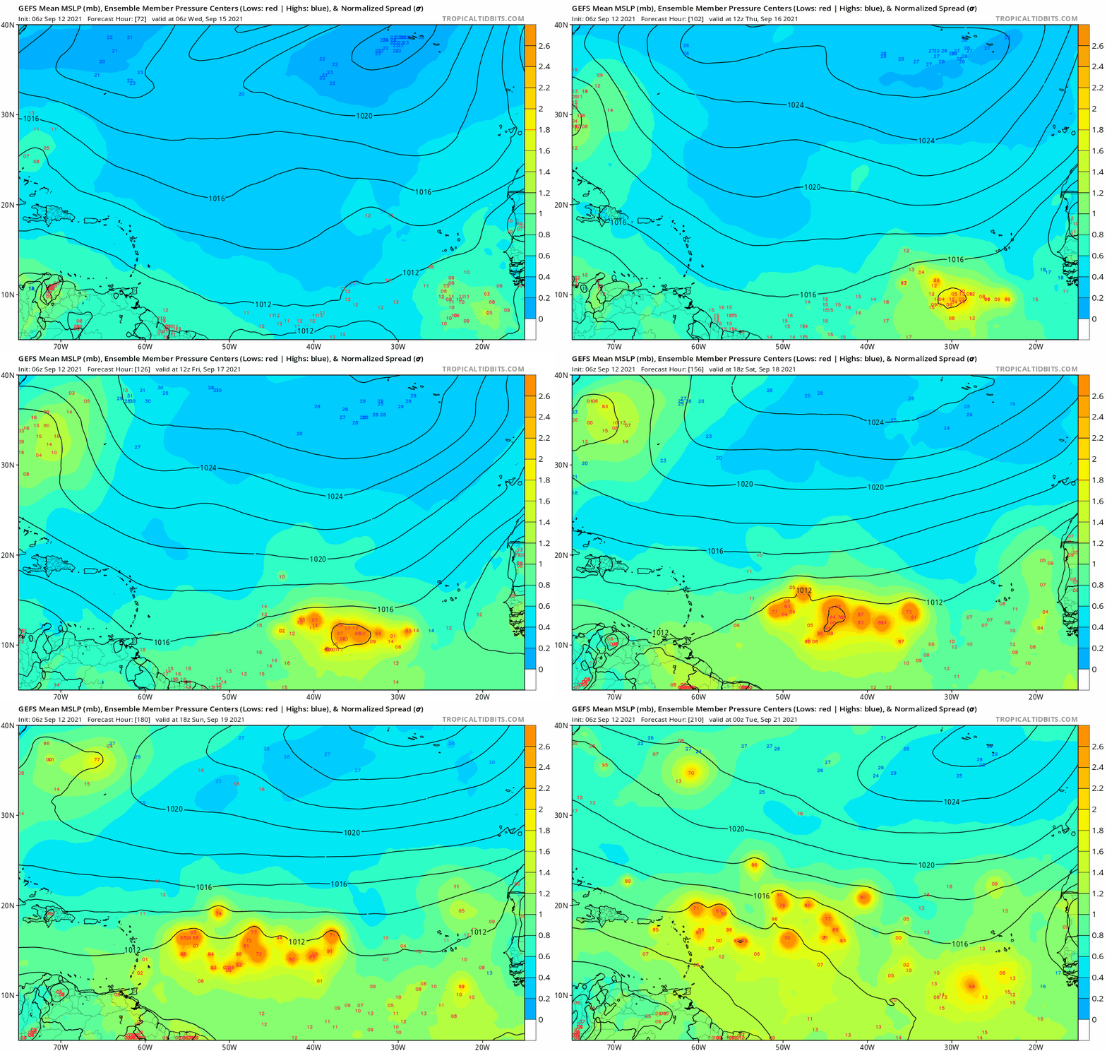
Hypercane_Kyle wrote:06z GEFS spread from Florida to 40W by Day 10. Even by Day 5 the uncertainty is pretty big.

06z operational GFS is clueless and is doing the usual splitting the vortex in two thing.


Yes big spread with the mean recurving east of the Lesser Antilles. From 72-210 hour animation:

Image
0 likes   

User avatar
toad strangler
S2K Supporter
S2K Supporter
Posts: 4173
Joined: Sun Jul 28, 2013 3:09 pm
Location: Earth
Contact:

Re: Strong Tropical Wave to emerge from West Africa early this week

#109 Postby toad strangler » Sun Sep 12, 2021 9:19 am

Shell Mound wrote:
SFLcane wrote:


Certainly don’t trust Eps that far out. Certainly no fish in the op.

https://i.postimg.cc/Hs1p1MtS/AA8-DCDD4-11-C9-4855-9572-AD692-C253-B71.gif

I would still trust the ensemble mean more than I would a single operational run. Furthermore, both the EPS and the operational EC show a TUTT-related weakness around ~25°N 52°W in a week (168h). Both the operational EC and a majority of the EPS members show a hurricane at that time, so the weakness near ~25°N 52°W allows a deepening hurricane to gain sufficient latitude as to miss the Leeward Islands and Hebert Box #1. If this system were to miss Hebert Box #1, the risk to South Florida would decrease substantially. If the system were to gain sufficient latitude before coming under the influence of the ridge, the chances of an OTS path, or at least a track that would miss the CONUS, would go up substantially, especially if both location and climatology are taken into account. So one does not need to know the long-range pattern in order to deduce a reasonable outcome, that is, OTS.


Like I said, it's easy to be a bear with far eastern systems. No matter what the calender says. OTS is the overwhelming climo outcome. Every time. Everybody knows it #easy to lean on.
Last edited by toad strangler on Sun Sep 12, 2021 9:21 am, edited 1 time in total.
3 likes   

User avatar
SFLcane
S2K Supporter
S2K Supporter
Posts: 9617
Age: 46
Joined: Sat Jun 05, 2010 1:44 pm
Location: Lake Worth Florida

Re: Strong Tropical Wave to emerge from West Africa early this week

#110 Postby SFLcane » Sun Sep 12, 2021 9:20 am

Ugly if it came to pass…

Image
2 likes   

Shell Mound
Category 5
Category 5
Posts: 2434
Age: 31
Joined: Thu Sep 07, 2017 3:39 pm
Location: St. Petersburg, FL → Scandinavia

Re: Strong Tropical Wave to emerge from West Africa early this week

#111 Postby Shell Mound » Sun Sep 12, 2021 9:26 am

SFLcane wrote:Ugly if it came to pass…

https://i.imgur.com/gwHW31f.gif

That model is highly unreliable. As for the operational ECMWF, it is well to the west of the EPS members. OTS and/or Bermuda is most plausible as of now.
0 likes   
CVW / MiamiensisWx / Shell Mound
The posts in this forum are NOT official forecasts and should not be used as such. They are just the opinion of the poster and may or may not be backed by sound meteorological data. They are NOT endorsed by any professional institution or STORM2K. For official information, please refer to products from the NHC and NWS.

User avatar
aspen
Category 5
Category 5
Posts: 8057
Joined: Sat Oct 12, 2019 7:10 pm
Location: Connecticut, USA

Re: Strong Tropical Wave to emerge from West Africa early this week

#112 Postby aspen » Sun Sep 12, 2021 9:28 am

SFLcane wrote:Ugly if it came to pass…

https://i.imgur.com/gwHW31f.gif

That would easily be a very intense Category 5 if that track and UL setup were to verify. 2-3 days over 29.5-31C SSTs that can support a sub-900mb storm with dual outflow channels…thank goodness that’s probably the SW limit of possible tracks.
1 likes   
Irene '11 Sandy '12 Hermine '16 5/15/2018 Derecho Fay '20 Isaias '20 Elsa '21 Henri '21 Ida '21

I am only a meteorology enthusiast who knows a decent amount about tropical cyclones. Look to the professional mets, the NHC, or your local weather office for the best information.

Shell Mound
Category 5
Category 5
Posts: 2434
Age: 31
Joined: Thu Sep 07, 2017 3:39 pm
Location: St. Petersburg, FL → Scandinavia

Re: Strong Tropical Wave to emerge from West Africa early this week

#113 Postby Shell Mound » Sun Sep 12, 2021 9:30 am

aspen wrote:
SFLcane wrote:Ugly if it came to pass…

https://i.imgur.com/gwHW31f.gif

That would easily be a very intense Category 5 if that track and UL setup were to verify. 2-3 days over 29.5-31C SSTs that can support a sub-900mb storm with dual outflow channels…thank goodness that’s probably the SW limit of possible tracks.

The Korean model is not a credible model. The operational ECMWF likely represents the westernmost outlier as of now. EPS/GEFS means are farther east.
0 likes   
CVW / MiamiensisWx / Shell Mound
The posts in this forum are NOT official forecasts and should not be used as such. They are just the opinion of the poster and may or may not be backed by sound meteorological data. They are NOT endorsed by any professional institution or STORM2K. For official information, please refer to products from the NHC and NWS.

User avatar
aspen
Category 5
Category 5
Posts: 8057
Joined: Sat Oct 12, 2019 7:10 pm
Location: Connecticut, USA

Re: Strong Tropical Wave to emerge from West Africa early this week

#114 Postby aspen » Sun Sep 12, 2021 9:33 am

Shell Mound wrote:
aspen wrote:
SFLcane wrote:Ugly if it came to pass…

https://i.imgur.com/gwHW31f.gif

That would easily be a very intense Category 5 if that track and UL setup were to verify. 2-3 days over 29.5-31C SSTs that can support a sub-900mb storm with dual outflow channels…thank goodness that’s probably the SW limit of possible tracks.

The Korean model is not a credible model. The operational ECMWF likely represents the westernmost outlier as of now. EPS/GEFS means are farther east.

If Chanthu were to pump the ridge more than what the Euro/GFS are showing (which is a big if this far out), then a track like that would be the SW limit. A Larry-like track or a track slightly further east would be the NE limit, although the EPS mean is definitely further SW than Larry’s track and could be a Jose-like close call for the Leeward Islands.
3 likes   
Irene '11 Sandy '12 Hermine '16 5/15/2018 Derecho Fay '20 Isaias '20 Elsa '21 Henri '21 Ida '21

I am only a meteorology enthusiast who knows a decent amount about tropical cyclones. Look to the professional mets, the NHC, or your local weather office for the best information.

User avatar
Category5Kaiju
Category 5
Category 5
Posts: 3404
Age: 22
Joined: Thu Dec 24, 2020 12:45 pm
Location: Seattle

Re: Strong Tropical Wave to emerge from West Africa early this week

#115 Postby Category5Kaiju » Sun Sep 12, 2021 9:37 am

toad strangler wrote:
Shell Mound wrote:
SFLcane wrote:
Certainly don’t trust Eps that far out. Certainly no fish in the op.

https://i.postimg.cc/Hs1p1MtS/AA8-DCDD4-11-C9-4855-9572-AD692-C253-B71.gif

I would still trust the ensemble mean more than I would a single operational run. Furthermore, both the EPS and the operational EC show a TUTT-related weakness around ~25°N 52°W in a week (168h). Both the operational EC and a majority of the EPS members show a hurricane at that time, so the weakness near ~25°N 52°W allows a deepening hurricane to gain sufficient latitude as to miss the Leeward Islands and Hebert Box #1. If this system were to miss Hebert Box #1, the risk to South Florida would decrease substantially. If the system were to gain sufficient latitude before coming under the influence of the ridge, the chances of an OTS path, or at least a track that would miss the CONUS, would go up substantially, especially if both location and climatology are taken into account. So one does not need to know the long-range pattern in order to deduce a reasonable outcome, that is, OTS.


Like I said, it's easy to be a bear with far eastern systems. No matter what the calender says. OTS is the overwhelming climo outcome. Every time. Everybody knows it #easy to lean on.


For the most part, yes. Until, that is, we get a storm that gives off a stern warning sign that it isn't likely to be completely OTS.
0 likes   
Unless explicitly stated, all information covered in my posts is based on my opinions and observations. Please refer to a professional meteorologist or an accredited weather research agency otherwise, especially if serious decisions must be made in the event of a potentially life-threatening tropical storm or hurricane.

User avatar
Hypercane_Kyle
Category 5
Category 5
Posts: 2900
Joined: Sat Mar 07, 2015 7:58 pm
Location: Cape Canaveral, FL

Re: Strong Tropical Wave to emerge from West Africa early this week

#116 Postby Hypercane_Kyle » Sun Sep 12, 2021 9:38 am

IMHO, the pattern in place favors a more western system than Larry. Stronger ridging looks present, and there's the unknown wildcard posed by the WPAC Super Typhoon.

At the same time, it's hard to get a storm to impact major landmass this time of year.

Here's the 00z EPS @ 240 hours. Should the system not develop quickly, this is not a good pattern to avoid land impacts.

Image
5 likes   
My posts are my own personal opinion, defer to the National Hurricane Center (NHC) and other NOAA products for decision making during hurricane season.

User avatar
Blown Away
S2K Supporter
S2K Supporter
Posts: 9867
Joined: Wed May 26, 2004 6:17 am

Re: 2021 Global Model Runs Discussion (Out thru day 16)

#117 Postby Blown Away » Sun Sep 12, 2021 9:53 am

Iceresistance wrote:Strongest Euro Model run yet on the 2nd Tropical Wave

https://s9.gifyu.com/images/ecmwf_mslpaNorm_atl_11.png


Days 7-10 leaving so much suspense with the slowdown... Looks like Caribbean will be a near miss and climatology says after Sept 20th a WNW path across the Atlantic will turn N to miss SFL/GOM but Mid Atlantic still in play... Doesn’t seem as a sure thing to turn N like Larry... Many days of watching ahead!!!
1 likes   
Hurricane Eye Experience: David 79, Irene 99, Frances 04, Jeanne 04, Wilma 05... EYE COMING MY WAY IN 2024…
Hurricane Brush Experience: Andrew 92, Erin 95, Floyd 99, Matthew 16, Irma 17, Ian 22, Nicole 22…

User avatar
chaser1
S2K Supporter
S2K Supporter
Posts: 4719
Age: 63
Joined: Sat Oct 15, 2005 5:59 pm
Location: Longwood, Fl

Re: Strong Tropical Wave to emerge from West Africa early this week

#118 Postby chaser1 » Sun Sep 12, 2021 10:06 am

SFLcane wrote:Ugly if it came to pass…

https://i.imgur.com/gwHW31f.gif


SFLcane, could you post the 500mb for that same time period for this Korean model? I'm curious what it's "downstream depiction" for CONUS toughing shows.
0 likes   
Personal Forecast Disclaimer:
The posts in this forum are NOT official forecast and should not be used as such. They are just the opinion of the poster and may or may not be backed by sound meteorological data. They are NOT endorsed by any professional institution or storm2k.org. For official information, please refer to the NHC and NWS products.


User avatar
chaser1
S2K Supporter
S2K Supporter
Posts: 4719
Age: 63
Joined: Sat Oct 15, 2005 5:59 pm
Location: Longwood, Fl

Re: 2021 Global Model Runs Discussion (Out thru day 16)

#119 Postby chaser1 » Sun Sep 12, 2021 10:15 am

Blown Away wrote:
Iceresistance wrote:Strongest Euro Model run yet on the 2nd Tropical Wave

https://s9.gifyu.com/images/ecmwf_mslpaNorm_atl_11.png


Days 7-10 leaving so much suspense with the slowdown... Looks like Caribbean will be a near miss and climatology says after Sept 20th a WNW path across the Atlantic will turn N to miss SFL/GOM but Mid Atlantic still in play... Doesn’t seem as a sure thing to turn N like Larry... Many days of watching ahead!!!


Agreed. If anomalous 500mb heights were to verify over the NE CONUS and SE Canada.... lookout Eastern Seaboard..... everyone from the Keys to the Northern GOM, to Maine could be in play.
0 likes   
Personal Forecast Disclaimer:
The posts in this forum are NOT official forecast and should not be used as such. They are just the opinion of the poster and may or may not be backed by sound meteorological data. They are NOT endorsed by any professional institution or storm2k.org. For official information, please refer to the NHC and NWS products.


AutoPenalti
Category 5
Category 5
Posts: 3950
Age: 27
Joined: Mon Aug 17, 2015 4:16 pm
Location: Ft. Lauderdale, Florida

Re: Strong Tropical Wave to emerge from West Africa early this week

#120 Postby AutoPenalti » Sun Sep 12, 2021 10:19 am

I’ve never seen a Korean model posted before. I wonder if it’s a standalone or if it uses a parent model.
1 likes   
The posts in this forum are NOT official forecasts and should not be used as such. They are just the opinion of the poster and may or may not be backed by sound meteorological data. They are NOT endorsed by any professional institution or STORM2K. For official information, please refer to products from the NHC and NWS.


Model Runs Cheat Sheet:
GFS (5:30 AM/PM, 11:30 AM/PM)
HWRF, GFDL, UKMET, NAVGEM (6:30-8:00 AM/PM, 12:30-2:00 AM/PM)
ECMWF (1:45 AM/PM)

TCVN
is a weighted averaged


Return to “Talkin' Tropics”

Who is online

Users browsing this forum: Google [Bot], LarryWx, Stratton23, Teban54, TheAustinMan and 27 guests