2018 Tropics: Global Model Runs Discussion (Out to day 16)
Moderator: S2k Moderators
Forum rules

The posts in this forum are NOT official forecasts and should not be used as such. They are just the opinion of the poster and may or may not be backed by sound meteorological data. They are NOT endorsed by any professional institution or STORM2K. For official information, please refer to products from the National Hurricane Center and National Weather Service.
-
floridasun78
- Category 5

- Posts: 3755
- Joined: Sun May 17, 2009 10:16 pm
- Location: miami fl
Re: 2018 Tropics: Global Model Runs Discussion (Out to day 16)
we better idea by Sunday or Monday see if models are right
0 likes
-
AtlanticWind

- S2K Supporter

- Posts: 1805
- Age: 65
- Joined: Sun Aug 08, 2004 9:57 pm
- Location: Plantation,Fla
Re: 2018 Tropics: Global Model Runs Discussion (Out to day 16)
Steve H. wrote:If development were to occur this would be a good area for it to happen certainly not at the pressures the model is showing. So development here in early June is certainly not out of the question.
This is showing a mid May storm ,not early june
0 likes
-
cycloneye

- Admin

- Posts: 139345
- Age: 67
- Joined: Thu Oct 10, 2002 10:54 am
- Location: San Juan, Puerto Rico
Re: 2018 Tropics: Global Model Runs Discussion (Out to day 16)
Someone said a few days ago the new FV3GFS may not be too laughable for other reasons but this tweet reinforces that in another front.
@BenNollWeather
The new GFS (FV3) has been more skillful than the old GFS over the past 3 months in the Northern Hemisphere.
Anomaly correlation for a 5-day forecast running a point higher ... appreciable improvement so far

https://twitter.com/BenNollWeather/status/994227794182844416
@BenNollWeather
The new GFS (FV3) has been more skillful than the old GFS over the past 3 months in the Northern Hemisphere.
Anomaly correlation for a 5-day forecast running a point higher ... appreciable improvement so far
https://twitter.com/BenNollWeather/status/994227794182844416
0 likes
Visit the Caribbean-Central America Weather Thread where you can find at first post web cams,radars
and observations from Caribbean basin members Click Here
and observations from Caribbean basin members Click Here
Re: 2018 Tropics: Global Model Runs Discussion (Out to day 16)
I'm confused about the FV3's resolution as I found the following at this website: https://vlab.ncep.noaa.gov/web/fv3gfs
"Resolution: C192 (~50km), C384 (~25km), C768 (~13km)"
Can anyone here explain this? Thanks in advance.
Edit: I found this elsewhere: "a cN grid is one with N grid cells across a cubed-sphere face."
So, C apparently stands for "cubed-sphere face".
"Resolution: C192 (~50km), C384 (~25km), C768 (~13km)"
Can anyone here explain this? Thanks in advance.
Edit: I found this elsewhere: "a cN grid is one with N grid cells across a cubed-sphere face."
So, C apparently stands for "cubed-sphere face".
Last edited by LarryWx on Wed May 09, 2018 11:00 am, edited 1 time in total.
0 likes
Personal Forecast Disclaimer:
The posts in this forum are NOT official forecasts and should not be used as such. They are just the opinion of the poster and may or may not be backed by sound meteorological data. They are NOT endorsed by any professional institution or storm2k.org. For official information, please refer to the NHC and NWS products.
The posts in this forum are NOT official forecasts and should not be used as such. They are just the opinion of the poster and may or may not be backed by sound meteorological data. They are NOT endorsed by any professional institution or storm2k.org. For official information, please refer to the NHC and NWS products.

Re: 2018 Tropics: Global Model Runs Discussion (Out to day 16)
LarryWx wrote:I'm confused about the FV3's resolution as I found the following at this website: https://vlab.ncep.noaa.gov/web/fv3gfs
"Resolution: C192 (~50km), C384 (~25km), C768 (~13km)"
Can anyone here explain this? Thanks in advance.
Must be a dead-ringer at C-1536
2 likes
Personal Forecast Disclaimer:
The posts in this forum are NOT official forecast and should not be used as such. They are just the opinion of the poster and may or may not be backed by sound meteorological data. They are NOT endorsed by any professional institution or storm2k.org. For official information, please refer to the NHC and NWS products.
The posts in this forum are NOT official forecast and should not be used as such. They are just the opinion of the poster and may or may not be backed by sound meteorological data. They are NOT endorsed by any professional institution or storm2k.org. For official information, please refer to the NHC and NWS products.
-
gatorcane

- S2K Supporter
- Posts: 23499
- Age: 46
- Joined: Sun Mar 13, 2005 3:54 pm
- Location: Boca Raton, FL
Re: 2018 Tropics: Global Model Runs Discussion (Out to day 16)
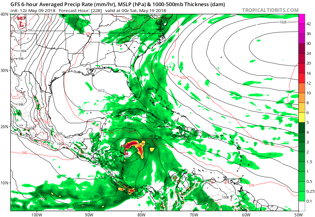
Looks like the GFS coming in now is going with development again out through 228 hours so far. Getting difficult to ignore the consistency with this model as we now are approaching the medium to long-range. Interesting that if we do get development the mid-level trough / low the models are showing forming near Florida late this weekend / early next week might be the key as to where the cyclone would track. If the trough forms further west in the Gulf, the cyclone may move more towards the Yucatan or southern Gulf but if the trough forms over Florida or east of, the cyclone would move more north into the weakness near Florida.
0 likes
-
cycloneye
- Admin
- Posts: 139345
- Age: 67
- Joined: Thu Oct 10, 2002 10:54 am
- Location: San Juan, Puerto Rico
Re: 2018 Tropics: Global Model Runs Discussion (Out to day 16)
tolakram wrote:IMO it will put in it the EPAC sooner or later.
12z GFS was trying hard to begin formation in EPAC at hour 168 but after this frame,it vanished and began in following frames to concentrate in SW Caribbean.

0 likes
Visit the Caribbean-Central America Weather Thread where you can find at first post web cams,radars
and observations from Caribbean basin members Click Here
and observations from Caribbean basin members Click Here
-
gatorcane
- S2K Supporter
- Posts: 23499
- Age: 46
- Joined: Sun Mar 13, 2005 3:54 pm
- Location: Boca Raton, FL
Re: 2018 Tropics: Global Model Runs Discussion (Out to day 16)
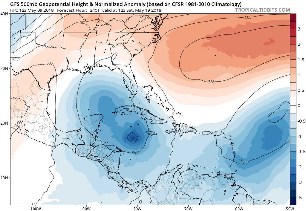
Day 10 the GFS is lifting the system north into that weakness left behind over the EGOM/Florida from that mid-level trough that forms later this weekend/early next week. 500MB heights show this well below:
0 likes
-
NotSparta

- Professional-Met

- Posts: 1655
- Age: 22
- Joined: Fri Aug 18, 2017 8:24 am
- Location: Naples, FL
- Contact:
Re: 2018 Tropics: Global Model Runs Discussion (Out to day 16)
gatorcane wrote:Looks like the GFS coming in now is going with development again out through 228 hours so far. Getting difficult to ignore the consistency with this model as we now are approaching the medium to long-range. Interesting that if we do get development the mid-level trough / low the models are showing forming near Florida late this weekend / early next week might be the key as to where the cyclone would track. If the trough forms further west in the Gulf, the cyclone may move more towards the Yucatan or southern Gulf but if the trough forms over Florida or east of, the cyclone would move more north into the weakness near Florida.
[img]https://s14.postimg.cc/47gjf0p81/gfs_mslp_pcpn_watl_38.png[img]
It's possible that Florida system is pulling the CAG north, more into the Atlantic, which allows for the formation of an ATL TC instead of an EPAC one
0 likes
This post was probably an opinion of mine, and in no way is official. Please refer to http://www.hurricanes.gov for official tropical analysis and advisories.
My website, with lots of tropical wx graphics, including satellite and recon: http://cyclonicwx.com
My website, with lots of tropical wx graphics, including satellite and recon: http://cyclonicwx.com
-
cycloneye
- Admin
- Posts: 139345
- Age: 67
- Joined: Thu Oct 10, 2002 10:54 am
- Location: San Juan, Puerto Rico
Re: 2018 Tropics: Global Model Runs Discussion (Out to day 16)
Not gonna happen says an expert.
@MJVentrice
Regarding the GFS fcst between fhr 210+ o/the Caribbean: I've seen the GFS do this a million times. It's a classic GFS false alarm. For whatever reason, the GFS likes to break this strip of low-level vorticity off of S. America in the med-range and spawn a TC. Not gonna happen.
https://twitter.com/MJVentrice/status/994258838311391232
2 likes
Visit the Caribbean-Central America Weather Thread where you can find at first post web cams,radars
and observations from Caribbean basin members Click Here
and observations from Caribbean basin members Click Here
-
HurricaneEnzo

- Category 2

- Posts: 724
- Joined: Wed Mar 14, 2018 12:18 pm
- Location: Newport, NC (Hurricane Alley)
Re: 2018 Tropics: Global Model Runs Discussion (Out to day 16)
I'm thinking this will probably end up being a TS in the Pacific if anything. The GooFuS seems like it is bad about putting the energy in the wrong place with these early season storms.
Of course you can't write it off 100% so keep an eye one it.
Of course you can't write it off 100% so keep an eye one it.
Last edited by HurricaneEnzo on Wed May 09, 2018 12:13 pm, edited 1 time in total.
1 likes
Bertha 96' - Fran 96' - Bonnie 98' - Dennis 99' - Floyd 99' - Isabel 03' - Alex 04' - Ophelia 05' - Irene 11' - Arthur 14' - Matthew 16' - Florence 18' - Dorian 19' - Isaias 20' (countless other tropical storms and Hurricane swipes)
I am not a Professional Met just an enthusiast. Get your weather forecasts from the Pros!
I am not a Professional Met just an enthusiast. Get your weather forecasts from the Pros!
-
wxman57

- Moderator-Pro Met

- Posts: 22484
- Age: 66
- Joined: Sat Jun 21, 2003 8:06 pm
- Location: Houston, TX (southwest)
Re: 2018 Tropics: Global Model Runs Discussion (Out to day 16)
HurricaneEnzo wrote:I think this will probably end up being a TS in the Pacific if anything. The GooFuS seems like it is bad about putting the energy in the wrong place with these early season storms.
Of course you can't write it off 100% so keep an eye one it.
That is my thinking as well. It always has issues this time of year with convection increasing in the East Pac.
4 likes
Re: 2018 Tropics: Global Model Runs Discussion (Out to day 16)
cycloneye wrote:Not gonna happen says an expert.
@MJVentrice
Regarding the GFS fcst between fhr 210+ o/the Caribbean: I've seen the GFS do this a million times. It's a classic GFS false alarm. For whatever reason, the GFS likes to break this strip of low-level vorticity off of S. America in the med-range and spawn a TC. Not gonna happen.
https://twitter.com/MJVentrice/status/994258838311391232
"1966 - Alma" NEVER Happened Either (Earliest Major Hurricane to impact the continental U.S., 2nd Earliest Hurricane on record to impact the continental U.S.)
1 likes
Personal Forecast Disclaimer:
The posts in this forum are NOT official forecast and should not be used as such. They are just the opinion of the poster and may or may not be backed by sound meteorological data. They are NOT endorsed by any professional institution or storm2k.org. For official information, please refer to the NHC and NWS products.
The posts in this forum are NOT official forecast and should not be used as such. They are just the opinion of the poster and may or may not be backed by sound meteorological data. They are NOT endorsed by any professional institution or storm2k.org. For official information, please refer to the NHC and NWS products.
Re: 2018 Tropics: Global Model Runs Discussion (Out to day 16)
Couple "fun facts" here:
1) Following Alma's early 1966 June impact on Cuba and much of Florida, the name Alma was oddly used again only 4 years later in 1970.
2) "This" 1970 Alma developed into one of the few Atlantic Hurricanes to ever develop during the month of May (May 20)
3) The ghost of Alma lives on - name last used in the Atlantic in 1974, yet the name was never formally retired from the Atlantic basin... nor ever used again either.
0 likes
Personal Forecast Disclaimer:
The posts in this forum are NOT official forecast and should not be used as such. They are just the opinion of the poster and may or may not be backed by sound meteorological data. They are NOT endorsed by any professional institution or storm2k.org. For official information, please refer to the NHC and NWS products.
The posts in this forum are NOT official forecast and should not be used as such. They are just the opinion of the poster and may or may not be backed by sound meteorological data. They are NOT endorsed by any professional institution or storm2k.org. For official information, please refer to the NHC and NWS products.
-
gatorcane
- S2K Supporter
- Posts: 23499
- Age: 46
- Joined: Sun Mar 13, 2005 3:54 pm
- Location: Boca Raton, FL
Re: 2018 Tropics: Global Model Runs Discussion (Out to day 16)
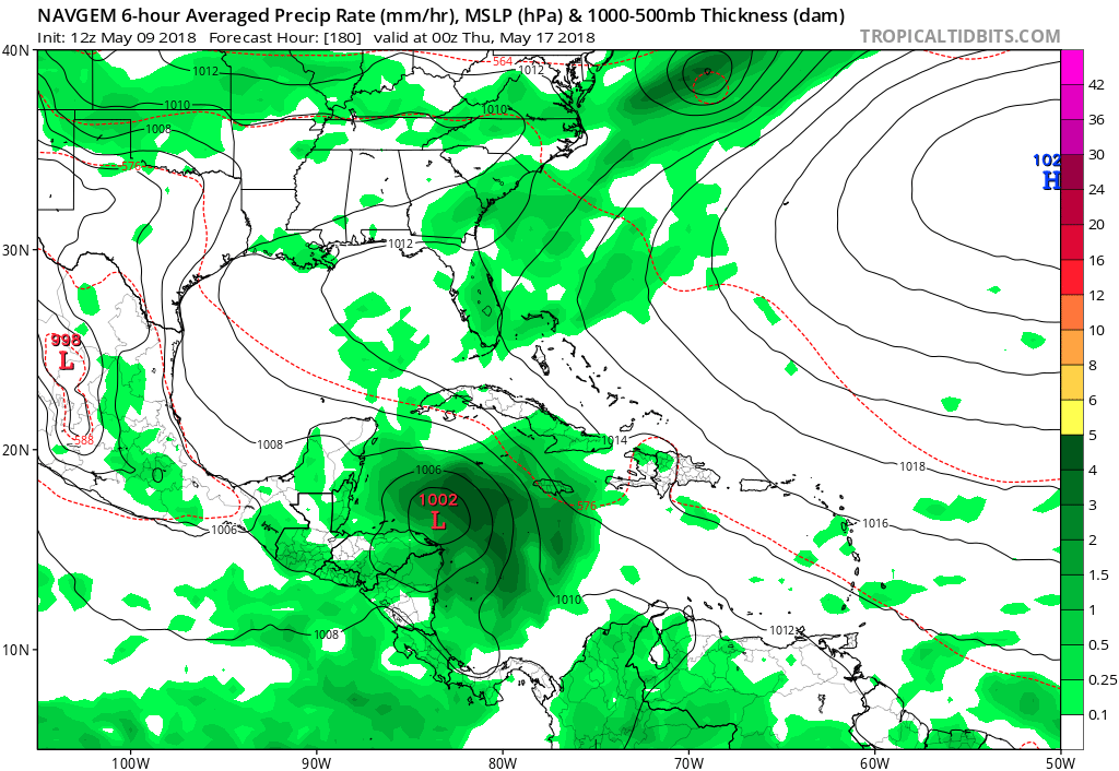
The NAVGEM is the only other model I see siding with the GFS but that is not a reliable model:
0 likes
-
TheStormExpert

- Category 5
- Posts: 8487
- Age: 30
- Joined: Wed Feb 16, 2011 5:38 pm
- Location: Palm Beach Gardens, FL
Re: 2018 Tropics: Global Model Runs Discussion (Out to day 16)
Yes this very well could end up developing in the East Pacific but what this could be telling us is that the Atlantic (especially the Western Caribbean and a Gulf) is more favorable than many are thinking. I mean why would the GFS consistently for many runs blowup a decent hurricane in the Western Caribbean/Gulf if conditions were that unfavorable?
0 likes
The following post is NOT an official forecast and should not be used as such. It is just the opinion of the poster and may or may not be backed by sound meteorological data. It is NOT endorsed by storm2k.org.
-
wxman57
- Moderator-Pro Met
- Posts: 22484
- Age: 66
- Joined: Sat Jun 21, 2003 8:06 pm
- Location: Houston, TX (southwest)
Re: 2018 Tropics: Global Model Runs Discussion (Out to day 16)
chaser1 wrote:
"1966 - Alma" NEVER Happened Either (Earliest Major Hurricane to impact the continental U.S., 2nd Earliest Hurricane on record to impact the continental U.S.)
Best track database has Alma striking Florida as a borderline Cat 1-2, not a major. It has Alma as a Cat 3 as it passed west of the Florida Peninsula. That said, this is most likely a phantom storm.
http://weather.unisys.com/hurricane/atlantic/1966/ALMA/track.dat

1 likes
Re: 2018 Tropics: Global Model Runs Discussion (Out to day 16)
Fortunately, the near miss distance of 50 or so miles made a significant difference for Key West and perhaps the S.W. Florida coastline. Key West received gusts in the 60-75mph range verses the sustained 125mph that Alma peaked at in the S.E. Gulf while passing west of Key West. That storm was definitely an aberration, but also Mother Nature's way of saying "I can if I want too" lol. I wouldn't be surprised if we were to see a wet sloppy tropical storm briefly develop over the W. Caribbean before perhaps bending back west over Central America or Yucatan.
0 likes
Personal Forecast Disclaimer:
The posts in this forum are NOT official forecast and should not be used as such. They are just the opinion of the poster and may or may not be backed by sound meteorological data. They are NOT endorsed by any professional institution or storm2k.org. For official information, please refer to the NHC and NWS products.
The posts in this forum are NOT official forecast and should not be used as such. They are just the opinion of the poster and may or may not be backed by sound meteorological data. They are NOT endorsed by any professional institution or storm2k.org. For official information, please refer to the NHC and NWS products.
Re: 2018 Tropics: Global Model Runs Discussion (Out to day 16)
Fun Poll Question: As indicated by present GFS long-term models, will the area of disturbed weather forecast to develop by May 22 -
A) Never Develop
B) Develop and remain a Pacific Tropical cyclone
C) Develop in the Atlantic but only reach Tropical Depression classification
D) Develop in the Atlantic but only reach Tropical Storm classification
E) Develop in the Atlantic as a rare pre-season Hurricane
(I haven't been burned by the GFS in months lol, i'm gonna guess "D")
0 likes
Personal Forecast Disclaimer:
The posts in this forum are NOT official forecast and should not be used as such. They are just the opinion of the poster and may or may not be backed by sound meteorological data. They are NOT endorsed by any professional institution or storm2k.org. For official information, please refer to the NHC and NWS products.
The posts in this forum are NOT official forecast and should not be used as such. They are just the opinion of the poster and may or may not be backed by sound meteorological data. They are NOT endorsed by any professional institution or storm2k.org. For official information, please refer to the NHC and NWS products.
-
floridasun78
- Category 5
- Posts: 3755
- Joined: Sun May 17, 2009 10:16 pm
- Location: miami fl
Re: 2018 Tropics: Global Model Runs Discussion (Out to day 16)
let wait and see 10 days out gfs could right like other models or could be all wrong
0 likes
Who is online
Users browsing this forum: bird, chaser1, IcyTundra, skyline385, Stratton23, Teban54, zzzh and 45 guests