Strong Tropical Wave to emerge from West Africa today (Is Invest 95L)

This is the general tropical discussion area. Anyone can take their shot at predicting a storms path.

Moderator: S2k Moderators

Forum rules

The posts in this forum are NOT official forecasts and should not be used as such. They are just the opinion of the poster and may or may not be backed by sound meteorological data. They are NOT endorsed by any professional institution or STORM2K. For official information, please refer to products from the National Hurricane Center and National Weather Service.

Help Support Storm2K
Message
Author
LarryWx
Category 5
Category 5
Posts: 5743
Joined: Sun Sep 07, 2003 2:04 pm
Location: GA

Re: Strong Tropical Wave to emerge from West Africa early this week

#121 Postby LarryWx » Sun Sep 12, 2021 11:00 am

aspen wrote:The 6z run continues to show how inept the GFS is at modeling tropical waves in the eastern Atlantic. Just like with Larry’s precursor, it has this wave interact with other areas of vorticity and get spun around/ripped apart. The Euro has done a far better job sniffing out MDR genesis so far this year, quite a change from its abysmal performance in 2020.

Speaking of the Euro, that 00z run would probably lead to a 120-130 kt Cat 4 with all the 29.5-30C waters it’ll be going over.


The Euro was absolutely abysmal with the wave that came off Friday. It had a sharply recurving TS+ on run after run vs the GFS, which always kept it a non-recurving weak low which is what has verified.
1 likes   
Personal Forecast Disclaimer:
The posts in this forum are NOT official forecasts and should not be used as such. They are just the opinion of the poster and may or may not be backed by sound meteorological data. They are NOT endorsed by any professional institution or storm2k.org. For official information, please refer to the NHC and NWS products.

Ulster
Tropical Wave
Tropical Wave
Posts: 2
Joined: Sun Sep 12, 2021 10:51 am

Re: Strong Tropical Wave to emerge from West Africa early this week

#122 Postby Ulster » Sun Sep 12, 2021 11:22 am

AutoPenalti wrote:I’ve never seen a Korean model posted before. I wonder if it’s a standalone or if it uses a parent model.


It leans on the Unified Model from the UK Met Office.
1 likes   

LarryWx
Category 5
Category 5
Posts: 5743
Joined: Sun Sep 07, 2003 2:04 pm
Location: GA

Re: Strong Tropical Wave to emerge from West Africa early this week

#123 Postby LarryWx » Sun Sep 12, 2021 11:22 am

12Z UKMET: has genesis at hour 60 but keeps it weak/moving WNW and then it dissipates:


NEW TROPICAL CYCLONE FORECAST TO DEVELOP AFTER 54 HOURS
FORECAST POSITION AT T+ 54 : 11.9N 20.6W

LEAD CENTRAL MAXIMUM WIND
VERIFYING TIME TIME POSITION PRESSURE (MB) SPEED (KNOTS)
-------------- ---- -------- ------------- -------------
0000UTC 15.09.2021 60 12.2N 22.3W 1010 29
1200UTC 15.09.2021 72 12.5N 26.3W 1010 30
0000UTC 16.09.2021 84 13.3N 30.0W 1012 29
1200UTC 16.09.2021 96 14.2N 34.1W 1013 29
0000UTC 17.09.2021 108 CEASED TRACKING
0 likes   
Personal Forecast Disclaimer:
The posts in this forum are NOT official forecasts and should not be used as such. They are just the opinion of the poster and may or may not be backed by sound meteorological data. They are NOT endorsed by any professional institution or storm2k.org. For official information, please refer to the NHC and NWS products.

LarryWx
Category 5
Category 5
Posts: 5743
Joined: Sun Sep 07, 2003 2:04 pm
Location: GA

Re: Strong Tropical Wave to emerge from West Africa early this week

#124 Postby LarryWx » Sun Sep 12, 2021 11:32 am

The 12Z ICON has this become a H that turns NNW by 45W up already to 20N (as a cat 2),which would have almost definitely meant never getting close to the SE US based on history even allowing for a more W movement for a period later on. I haven’t found even one storm on record back to 1851 moving NW to NNW that far east in the MDR able to come back to the US. I did that research several years ago and was frankly surprised. That is an example where knowing climo is helpful.
Last edited by LarryWx on Sun Sep 12, 2021 11:39 am, edited 1 time in total.
1 likes   
Personal Forecast Disclaimer:
The posts in this forum are NOT official forecasts and should not be used as such. They are just the opinion of the poster and may or may not be backed by sound meteorological data. They are NOT endorsed by any professional institution or storm2k.org. For official information, please refer to the NHC and NWS products.

User avatar
aspen
Category 5
Category 5
Posts: 8057
Joined: Sat Oct 12, 2019 7:10 pm
Location: Connecticut, USA

Re: Strong Tropical Wave to emerge from West Africa early this week

#125 Postby aspen » Sun Sep 12, 2021 11:39 am

LarryWx wrote:The 12Z ICON has this become a H that turns NNW by 45W up already to 20N (as a cat 2),which would have almost definitely meant never getting close to the SE US based on history even allowing for a more W movement for a period later on. I haven’t found even one storm on record back to 1851 moving NW to NNW that far east in the MDR able to come back to the US. I did that research several years ago.

Seems like the Bahamas AOI, both as a TC and a post-tropical low, open up a gap in the ridge that the hurricane takes advantage of. This is on the far eastern side of the range of tracks other models show, however.

The GFS is still garbage at modeling AEWs and splits this apart yet again. We’ll have to wait for the ensembles to see if the 12z guidance is seeing an east shift.
0 likes   
Irene '11 Sandy '12 Hermine '16 5/15/2018 Derecho Fay '20 Isaias '20 Elsa '21 Henri '21 Ida '21

I am only a meteorology enthusiast who knows a decent amount about tropical cyclones. Look to the professional mets, the NHC, or your local weather office for the best information.

User avatar
gatorcane
S2K Supporter
S2K Supporter
Posts: 23499
Age: 46
Joined: Sun Mar 13, 2005 3:54 pm
Location: Boca Raton, FL

Re: Strong Tropical Wave to emerge from West Africa early this week

#126 Postby gatorcane » Sun Sep 12, 2021 11:40 am

LarryWx wrote:The 12Z ICON has this become a H that turns NNW by 45W up already to 20N (as a cat 2),which would have almost definitely meant never getting close to the SE US based on history even allowing for a more W movement for a period later on. I haven’t found even one storm on record back to 1851 moving NW to NNW that far east in the MDR able to come back to the US. I did that research several years ago and was frankly surprised.


:fishing:

Image
0 likes   

LarryWx
Category 5
Category 5
Posts: 5743
Joined: Sun Sep 07, 2003 2:04 pm
Location: GA

Re: Strong Tropical Wave to emerge from West Africa early this week

#127 Postby LarryWx » Sun Sep 12, 2021 11:42 am

aspen wrote:
LarryWx wrote:The 12Z ICON has this become a H that turns NNW by 45W up already to 20N (as a cat 2),which would have almost definitely meant never getting close to the SE US based on history even allowing for a more W movement for a period later on. I haven’t found even one storm on record back to 1851 moving NW to NNW that far east in the MDR able to come back to the US. I did that research several years ago.

Seems like the Bahamas AOI, both as a TC and a post-tropical low, open up a gap in the ridge that the hurricane takes advantage of. This is on the far eastern side of the range of tracks other models show, however.

The GFS is still garbage at modeling AEWs and splits this apart yet again. We’ll have to wait for the ensembles to see if the 12z guidance is seeing an east shift.


But as mentioned, the GFS did very well with the wave currently in the eastern Atlantic as it always kept it weak vs the Euro, UKMET, and ICON, which all had many runs of TS+.
1 likes   
Personal Forecast Disclaimer:
The posts in this forum are NOT official forecasts and should not be used as such. They are just the opinion of the poster and may or may not be backed by sound meteorological data. They are NOT endorsed by any professional institution or storm2k.org. For official information, please refer to the NHC and NWS products.

User avatar
gatorcane
S2K Supporter
S2K Supporter
Posts: 23499
Age: 46
Joined: Sun Mar 13, 2005 3:54 pm
Location: Boca Raton, FL

Re: Strong Tropical Wave to emerge from West Africa early this week

#128 Postby gatorcane » Sun Sep 12, 2021 11:45 am

LarryWx wrote:
aspen wrote:
LarryWx wrote:The 12Z ICON has this become a H that turns NNW by 45W up already to 20N (as a cat 2),which would have almost definitely meant never getting close to the SE US based on history even allowing for a more W movement for a period later on. I haven’t found even one storm on record back to 1851 moving NW to NNW that far east in the MDR able to come back to the US. I did that research several years ago.

Seems like the Bahamas AOI, both as a TC and a post-tropical low, open up a gap in the ridge that the hurricane takes advantage of. This is on the far eastern side of the range of tracks other models show, however.

The GFS is still garbage at modeling AEWs and splits this apart yet again. We’ll have to wait for the ensembles to see if the 12z guidance is seeing an east shift.


But as mentioned, the GFS did very well with the wave currently in the eastern Atlantic as it always kept it weak vs the Euro, UKMET, and ICON, which all had many runs of TS+.


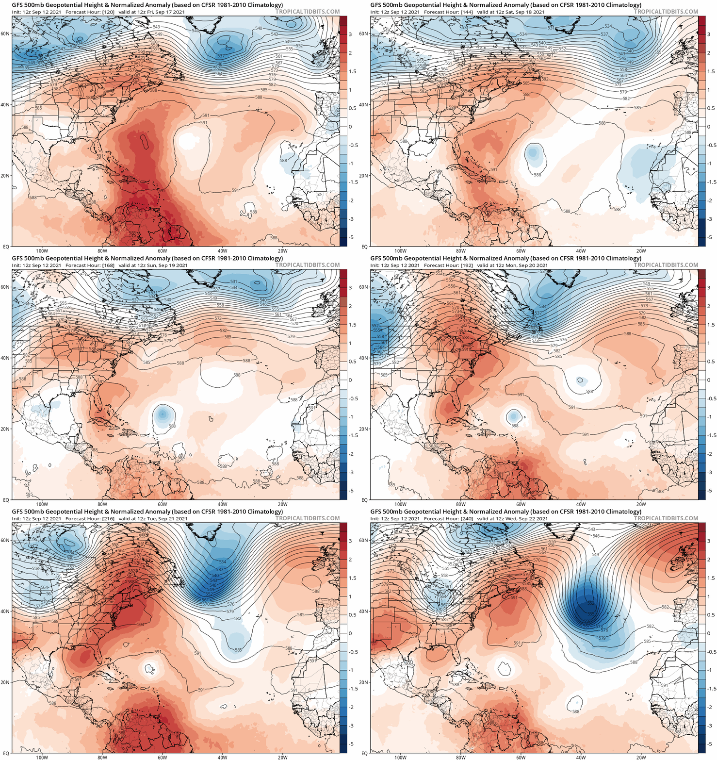
Here is the 12Z GFS from 120 hour animation. Look at that trough over the Azores which looks to really slow the progress westward of this wave. Very fall-like progressive pattern on the GFS.

Image
0 likes   

User avatar
gatorcane
S2K Supporter
S2K Supporter
Posts: 23499
Age: 46
Joined: Sun Mar 13, 2005 3:54 pm
Location: Boca Raton, FL

Re: Strong Tropical Wave to emerge from West Africa early this week

#129 Postby gatorcane » Sun Sep 12, 2021 11:55 am

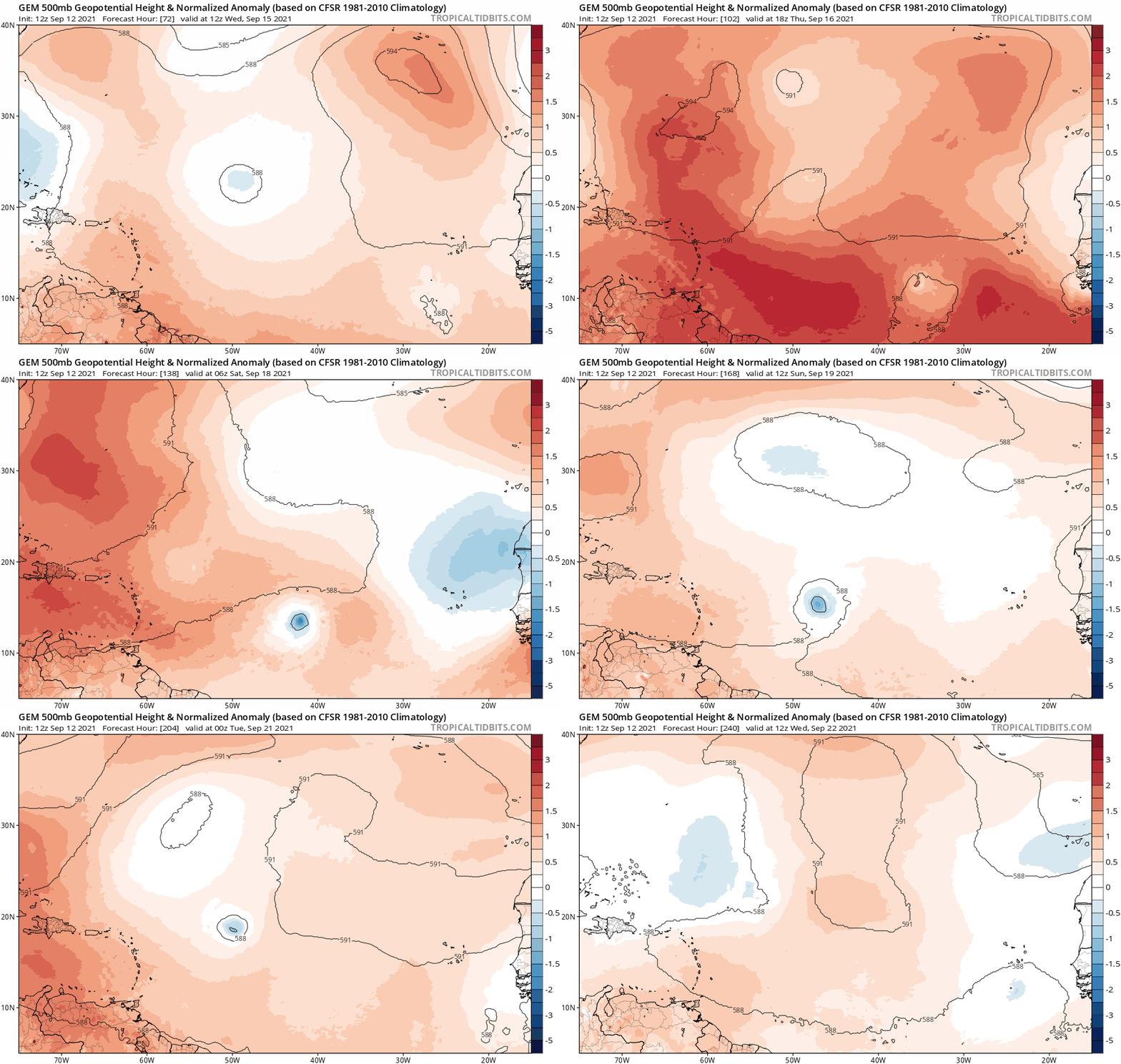
It is notable that the CMC has trended weaker from yesterday’s runs but not quite as weak as the GFS. Also has trended more north. Looks like :fishing:

Image
0 likes   

LarryWx
Category 5
Category 5
Posts: 5743
Joined: Sun Sep 07, 2003 2:04 pm
Location: GA

Re: Strong Tropical Wave to emerge from West Africa early this week

#130 Postby LarryWx » Sun Sep 12, 2021 11:56 am

gatorcane wrote:
LarryWx wrote:The 12Z ICON has this become a H that turns NNW by 45W up already to 20N (as a cat 2),which would have almost definitely meant never getting close to the SE US based on history even allowing for a more W movement for a period later on. I haven’t found even one storm on record back to 1851 moving NW to NNW that far east in the MDR able to come back to the US. I did that research several years ago and was frankly surprised.


:fishing:

https://i.postimg.cc/Rh4hw9yM/icon-mslp-pcpn-eatl-fh60-180.gif


Looking like it now per model consensus, especially if it becomes strong early but still too early imo to make a confident call as it is still over Africa. Lots can still change as a few EPS members have shown and also if it stays weak quite far west.
0 likes   
Personal Forecast Disclaimer:
The posts in this forum are NOT official forecasts and should not be used as such. They are just the opinion of the poster and may or may not be backed by sound meteorological data. They are NOT endorsed by any professional institution or storm2k.org. For official information, please refer to the NHC and NWS products.

LarryWx
Category 5
Category 5
Posts: 5743
Joined: Sun Sep 07, 2003 2:04 pm
Location: GA

Re: Strong Tropical Wave to emerge from West Africa early this week

#131 Postby LarryWx » Sun Sep 12, 2021 12:08 pm

The 12Z GEFS once again has many geneses but it also looks very fishy.
0 likes   
Personal Forecast Disclaimer:
The posts in this forum are NOT official forecasts and should not be used as such. They are just the opinion of the poster and may or may not be backed by sound meteorological data. They are NOT endorsed by any professional institution or storm2k.org. For official information, please refer to the NHC and NWS products.

User avatar
cycloneye
Admin
Admin
Posts: 139351
Age: 67
Joined: Thu Oct 10, 2002 10:54 am
Location: San Juan, Puerto Rico

Re: Strong Tropical Wave to emerge from West Africa early this week

#132 Postby cycloneye » Sun Sep 12, 2021 12:35 pm

Another tropical wave is forecast to move off the west coast of
Africa on Monday. Gradual development of this system is possible
thereafter, and a tropical depression could form by the middle of
the week while it moves westward across the eastern tropical
Atlantic Ocean.
* Formation chance through 48 hours...low...20 percent.
* Formation chance through 5 days...medium...60 percent.
0 likes   
Visit the Caribbean-Central America Weather Thread where you can find at first post web cams,radars
and observations from Caribbean basin members Click Here

User avatar
Blown Away
S2K Supporter
S2K Supporter
Posts: 9867
Joined: Wed May 26, 2004 6:17 am

Re: Strong Tropical Wave to emerge from West Africa early this week

#133 Postby Blown Away » Sun Sep 12, 2021 12:36 pm

LarryWx wrote:The 12Z GEFS once again has many geneses but it also looks very fishy.


Huge spread from day 7-10, which should be expected, but there are a number of ensembles that shifted SW. Certainly not a slam dunk fish ATM.
2 likes   
Hurricane Eye Experience: David 79, Irene 99, Frances 04, Jeanne 04, Wilma 05... EYE COMING MY WAY IN 2024…
Hurricane Brush Experience: Andrew 92, Erin 95, Floyd 99, Matthew 16, Irma 17, Ian 22, Nicole 22…

AutoPenalti
Category 5
Category 5
Posts: 3950
Age: 27
Joined: Mon Aug 17, 2015 4:16 pm
Location: Ft. Lauderdale, Florida

Re: Strong Tropical Wave to emerge from West Africa early this week

#134 Postby AutoPenalti » Sun Sep 12, 2021 12:42 pm

Ulster wrote:
AutoPenalti wrote:I’ve never seen a Korean model posted before. I wonder if it’s a standalone or if it uses a parent model.


It leans on the Unified Model from the UK Met Office.

That’s pretty cool, Is there documentation on how it operates?
0 likes   
The posts in this forum are NOT official forecasts and should not be used as such. They are just the opinion of the poster and may or may not be backed by sound meteorological data. They are NOT endorsed by any professional institution or STORM2K. For official information, please refer to products from the NHC and NWS.


Model Runs Cheat Sheet:
GFS (5:30 AM/PM, 11:30 AM/PM)
HWRF, GFDL, UKMET, NAVGEM (6:30-8:00 AM/PM, 12:30-2:00 AM/PM)
ECMWF (1:45 AM/PM)

TCVN
is a weighted averaged

LarryWx
Category 5
Category 5
Posts: 5743
Joined: Sun Sep 07, 2003 2:04 pm
Location: GA

Re: Strong Tropical Wave to emerge from West Africa early this week

#135 Postby LarryWx » Sun Sep 12, 2021 12:50 pm

Blown Away wrote:
LarryWx wrote:The 12Z GEFS once again has many geneses but it also looks very fishy.


Huge spread from day 7-10, which should be expected, but there are a number of ensembles that shifted SW. Certainly not a slam dunk fish ATM.


With it still being over Africa and with such a complex setup, it most certainly isn’t a slam dunk miss of the Conus even though that is favored. It would still be two weeks away if it were to hit.
0 likes   
Personal Forecast Disclaimer:
The posts in this forum are NOT official forecasts and should not be used as such. They are just the opinion of the poster and may or may not be backed by sound meteorological data. They are NOT endorsed by any professional institution or storm2k.org. For official information, please refer to the NHC and NWS products.

User avatar
Category5Kaiju
Category 5
Category 5
Posts: 3404
Age: 22
Joined: Thu Dec 24, 2020 12:45 pm
Location: Seattle

Re: Strong Tropical Wave to emerge from West Africa early this week

#136 Postby Category5Kaiju » Sun Sep 12, 2021 1:02 pm

What I am trying to figure out is the reason why models want it to recurve; is it the Bahamas AOI that causes a breach in the ridge? Or is Chanthu not doing enough to enhance the Canadian ridge? Or is it something else entirely? Either way, one part of me still wants to keep an eye on this storm as it definitely does not look as OTS-definitive as Larry did in its formative stages, and I still remember that graphic Eric Webb posted in July or so about ASO having an anomalously high level of Canadian ridging.
0 likes   
Unless explicitly stated, all information covered in my posts is based on my opinions and observations. Please refer to a professional meteorologist or an accredited weather research agency otherwise, especially if serious decisions must be made in the event of a potentially life-threatening tropical storm or hurricane.

User avatar
SFLcane
S2K Supporter
S2K Supporter
Posts: 9617
Age: 46
Joined: Sat Jun 05, 2010 1:44 pm
Location: Lake Worth Florida

Re: Strong Tropical Wave to emerge from West Africa early this week

#137 Postby SFLcane » Sun Sep 12, 2021 1:12 pm

And we’re is the tc on the 12z euro? Totally different upper air pattern also
0 likes   

User avatar
gatorcane
S2K Supporter
S2K Supporter
Posts: 23499
Age: 46
Joined: Sun Mar 13, 2005 3:54 pm
Location: Boca Raton, FL

Re: Strong Tropical Wave to emerge from West Africa early this week

#138 Postby gatorcane » Sun Sep 12, 2021 1:15 pm

About face on the Euro. Totally drops it through 96 hours so far. Looks like the GFS may have been right all along :blowup:
1 likes   

Ulster
Tropical Wave
Tropical Wave
Posts: 2
Joined: Sun Sep 12, 2021 10:51 am

Re: Strong Tropical Wave to emerge from West Africa early this week

#139 Postby Ulster » Sun Sep 12, 2021 1:18 pm

AutoPenalti wrote:
Ulster wrote:
AutoPenalti wrote:I’ve never seen a Korean model posted before. I wonder if it’s a standalone or if it uses a parent model.


It leans on the Unified Model from the UK Met Office.

That’s pretty cool, Is there documentation on how it operates?


I think if you google KMA and KIM you can find some papers on it. I am in the supercomputer business so I only know core dependencies but not underlying details.
0 likes   

User avatar
Stormybajan
Category 1
Category 1
Posts: 428
Joined: Thu May 20, 2021 3:21 pm
Location: Windward Islands

Re: Strong Tropical Wave to emerge from West Africa early this week

#140 Postby Stormybajan » Sun Sep 12, 2021 1:20 pm

Andddd...the 12z euro has some strungout energy. Such a massive change from what it had before. It wouldnt be a good look for the euro if this doesnt become a strong system after being so consistent. Especially being completely wrong about 93L also ..lets see what happens after 96 hours in this run..not expecting much
0 likes   
Sad West Indies and Manchester United fan ⚽️


Return to “Talkin' Tropics”

Who is online

Users browsing this forum: cycloneye, Pas_Bon and 62 guests