2020 Indicators: SST's / SAL / MSLP / Steering / Shear / Instability / Sat Images

This is the general tropical discussion area. Anyone can take their shot at predicting a storms path.

Moderator: S2k Moderators

Forum rules

The posts in this forum are NOT official forecasts and should not be used as such. They are just the opinion of the poster and may or may not be backed by sound meteorological data. They are NOT endorsed by any professional institution or STORM2K. For official information, please refer to products from the National Hurricane Center and National Weather Service.

Help Support Storm2K
Message
Author
User avatar
toad strangler
S2K Supporter
S2K Supporter
Posts: 4176
Joined: Sun Jul 28, 2013 3:09 pm
Location: Earth
Contact:

Re: 2020 Indicators: SST's / SAL / MSLP / Steering / Shear / Instability / Sat Images

#1221 Postby toad strangler » Tue Jun 30, 2020 6:46 am

NDG wrote:
toad strangler wrote:
NDG wrote:
You are incorrect, you didn't finished reading when SAL peaks, "Saharan Air Layer activity usually ramps up in mid-June, peaks from late June to mid-August,
and begins to rapidly subside after mid-Augustt". So in another words in average July is when is at its worst, proven by previous years. And by the way things look it could very well continue to through July.

https://www.weather.gov/media/zhu/Sahar ... _Plume.pdf


I think we are splitting hairs here and I wouldn't state that I'm incorrect. The last 17 years have had SAL peak average in late June. Post #1161 in this thread. Also, I have previously mentioned that SAL can easily reign through July and even the first half of August. There would be nothing abnormal about that.


So why would you say that "SAL peaks in late late June and that it tails off throughout July" is either A or B, make up your mind :lol: :lol: :lol:


Look at the chart I posted. It tails off. Just like hurricane activity does post September 10th. Does that mean there can't be huge activity afterward? Of course not. :lol: I'd say you are missing context by a large margin.
0 likes   

User avatar
NDG
S2K Supporter
S2K Supporter
Posts: 14934
Joined: Sun Jul 09, 2006 10:14 pm
Location: Orlando, FL

Re: 2020 Indicators: SST's / SAL / MSLP / Steering / Shear / Instability / Sat Images

#1222 Postby NDG » Tue Jun 30, 2020 6:59 am

toad strangler wrote:
NDG wrote:
toad strangler wrote:
I think we are splitting hairs here and I wouldn't state that I'm incorrect. The last 17 years have had SAL peak average in late June. Post #1161 in this thread. Also, I have previously mentioned that SAL can easily reign through July and even the first half of August. There would be nothing abnormal about that.


So why would you say that "SAL peaks in late late June and that it tails off throughout July" is either A or B, make up your mind :lol: :lol: :lol:


Look at the chart I posted. It tails off. Just like hurricane activity does post September 10th. Does that mean there can't be huge activity afterward? Of course not. :lol: I'd say you are missing context by a large margin.


I think the chart is meant to show that the peak is July, not late June, because everything that I have read says that the peak of SAL is during the month of July. I have asked Michael Lowry.

Image
1 likes   

User avatar
toad strangler
S2K Supporter
S2K Supporter
Posts: 4176
Joined: Sun Jul 28, 2013 3:09 pm
Location: Earth
Contact:

Re: 2020 Indicators: SST's / SAL / MSLP / Steering / Shear / Instability / Sat Images

#1223 Postby toad strangler » Tue Jun 30, 2020 7:13 am

NDG wrote:
toad strangler wrote:
NDG wrote:
So why would you say that "SAL peaks in late late June and that it tails off throughout July" is either A or B, make up your mind :lol: :lol: :lol:


Look at the chart I posted. It tails off. Just like hurricane activity does post September 10th. Does that mean there can't be huge activity afterward? Of course not. :lol: I'd say you are missing context by a large margin.


I think the chart is meant to show that the peak is July, not late June, because everything that I have read says that the peak of SAL is during the month of July. I have asked Michael Lowry.

https://i.imgur.com/Mc8ECI3.jpg


July is definitely in the SAL peak period for sure. I was referencing late June as THE peak as in we reference Sept 10th as THE peak of hurricane season. That's where we crossed wires lol. All good discussion.
0 likes   

User avatar
NDG
S2K Supporter
S2K Supporter
Posts: 14934
Joined: Sun Jul 09, 2006 10:14 pm
Location: Orlando, FL

Re: 2020 Indicators: SST's / SAL / MSLP / Steering / Shear / Instability / Sat Images

#1224 Postby NDG » Tue Jun 30, 2020 7:16 am

toad strangler wrote:
NDG wrote:
toad strangler wrote:
Look at the chart I posted. It tails off. Just like hurricane activity does post September 10th. Does that mean there can't be huge activity afterward? Of course not. :lol: I'd say you are missing context by a large margin.


I think the chart is meant to show that the peak is July, not late June, because everything that I have read says that the peak of SAL is during the month of July. I have asked Michael Lowry.

https://i.imgur.com/Mc8ECI3.jpg


July is definitely in the SAL peak period for sure. I was referencing late June as THE peak as in we reference Sept 10th as THE peak of hurricane season. That's where we crossed wires lol. All good discussion.


That's where we disagree, you say late June I say near the middle of July, as the Sept 10th of the peak of the hurricane season :D
0 likes   

USTropics
Category 5
Category 5
Posts: 2420
Joined: Sun Aug 12, 2007 3:45 am
Location: Florida State University

Re: 2020 Indicators: SST's / SAL / MSLP / Steering / Shear / Instability / Sat Images

#1225 Postby USTropics » Tue Jun 30, 2020 7:18 am

It's definitely not a hard date (i.e. every year on July 15th we'll be at peak SAL for the season). You have to find the root component. What has the biggest influence on SAL propagation? Pressure gradient changes between seasonal positions of the ITCZ:
Image

What influences the ITCZ wanting to lift north? SSTA temperature differences between northern/southern Atlantic:
Image

Given the current SSTA configuration and current ITCZ location relative to climo, we should be seeing a typical peak sometime between now and mid/late July:
Image

Most likely the next suppressed passage (mid-late July) will once again promote increased easterlies in the upper atmosphere, which is typically when we see the most extensive SAL outbreaks:
Image
6 likes   

Shell Mound
Category 5
Category 5
Posts: 2434
Age: 31
Joined: Thu Sep 07, 2017 3:39 pm
Location: St. Petersburg, FL → Scandinavia

Re: 2020 Indicators: SST's / SAL / MSLP / Steering / Shear / Instability / Sat Images

#1226 Postby Shell Mound » Tue Jun 30, 2020 7:21 am

According to data from ESRL’s NCEP/NCAR SST reanalysis, the AMO in June ‘20 has been cooler than in June ‘17, owing to greater North Atlantic Deep Water (NADW) penetration. This is why slight changes in the synoptic pattern produce significant ± fluctuations in SSTs across the North Atlantic basin, given the presence of very cold subsurface waters in the eastern subtropics and far North Atlantic. I’m still uncertain as to whether cool neutral ENSO and a strong WAM/AEJ will be sufficient to overcome the rather anaemic state of the AMO. The AMO, to me, is the biggest potential negative factor that could hinder the 2020 Atlantic hurricane season, not the SAL. Only one and a half week of ridging over the Northwestern Atlantic has been sufficient to eliminate well-below-average SSTs and build a massive warm pool off New England and the Mid-Atlantic region—a feature that is typical of a -AMO regime. This means that the subsurface over the Northwestern (Northeastern) Atlantic is very warm (cold) and easily reaches the surface as soon as low-level winds slacken (strengthen) and veer (back). I would pay more attention to the subsurface than the surface when gauging the state of the AMO. Even if the MDR/Caribbean have been mostly above average for most of June, the preponderance of cold NADW in the eastern subtropics/far North Atlantic means that as soon as trade winds strengthen, virtually all the warm SSTs vanish, as they have in just the past week. Now SSTs in the MDR/Caribbean are average to below average at best.
0 likes   
CVW / MiamiensisWx / Shell Mound
The posts in this forum are NOT official forecasts and should not be used as such. They are just the opinion of the poster and may or may not be backed by sound meteorological data. They are NOT endorsed by any professional institution or STORM2K. For official information, please refer to products from the NHC and NWS.

User avatar
SFLcane
S2K Supporter
S2K Supporter
Posts: 9620
Age: 46
Joined: Sat Jun 05, 2010 1:44 pm
Location: Lake Worth Florida

Re: 2020 Indicators: SST's / SAL / MSLP / Steering / Shear / Instability / Sat Images

#1227 Postby SFLcane » Tue Jun 30, 2020 7:58 am

toad strangler wrote:
NDG wrote:
toad strangler wrote:
Look at the chart I posted. It tails off. Just like hurricane activity does post September 10th. Does that mean there can't be huge activity afterward? Of course not. :lol: I'd say you are missing context by a large margin.


I think the chart is meant to show that the peak is July, not late June, because everything that I have read says that the peak of SAL is during the month of July. I have asked Michael Lowry.

https://i.imgur.com/Mc8ECI3.jpg


July is definitely in the SAL peak period for sure. I was referencing late June as THE peak as in we reference Sept 10th as THE peak of hurricane season. That's where we crossed wires lol. All good discussion.


It never fails every year we get bouts of SAL around this time of the year it generally peaks around mid July but yet the thread is flooded with season cancel posts only to see 5-6 storms develop in Aug. Patience grasshoppers
3 likes   

User avatar
toad strangler
S2K Supporter
S2K Supporter
Posts: 4176
Joined: Sun Jul 28, 2013 3:09 pm
Location: Earth
Contact:

Re: 2020 Indicators: SST's / SAL / MSLP / Steering / Shear / Instability / Sat Images

#1228 Postby toad strangler » Tue Jun 30, 2020 7:58 am

SFLcane wrote:
toad strangler wrote:
NDG wrote:
I think the chart is meant to show that the peak is July, not late June, because everything that I have read says that the peak of SAL is during the month of July. I have asked Michael Lowry.

https://i.imgur.com/Mc8ECI3.jpg


July is definitely in the SAL peak period for sure. I was referencing late June as THE peak as in we reference Sept 10th as THE peak of hurricane season. That's where we crossed wires lol. All good discussion.


It never fails every year we get bouts of SAL around this time of the year it generally peaks around mid July but yet the thread is flooded with season cancel posts only to see 5-6 storms develop in Aug. Patience grasshoppers


I haven't seen one cancel post of any kind.
0 likes   

USTropics
Category 5
Category 5
Posts: 2420
Joined: Sun Aug 12, 2007 3:45 am
Location: Florida State University

Re: 2020 Indicators: SST's / SAL / MSLP / Steering / Shear / Instability / Sat Images

#1229 Postby USTropics » Tue Jun 30, 2020 8:10 am

A very informative article by Jeff Masters (https://www.yaleclimateconnections.org/ ... n-decades/) was posted last night regarding SAL and its effects on the recent MDR cooling (-0.4C average). As we thought, this was quite a historic SAL outbreak:

Image
2 likes   

User avatar
toad strangler
S2K Supporter
S2K Supporter
Posts: 4176
Joined: Sun Jul 28, 2013 3:09 pm
Location: Earth
Contact:

Re: 2020 Indicators: SST's / SAL / MSLP / Steering / Shear / Instability / Sat Images

#1230 Postby toad strangler » Tue Jun 30, 2020 8:25 am

USTropics wrote:A very informative article by Jeff Masters (https://www.yaleclimateconnections.org/ ... n-decades/) was posted last night regarding SAL and its effects on the recent MDR cooling (-0.4C average). As we thought, this was quite a historic SAL outbreak:

https://i.ibb.co/xz9FD2C/0620-Lowry-Fig1.jpg


Man ….. that is as far out as the excessive May/June African rain anomalies..... :eek:
1 likes   

MarioProtVI
Category 2
Category 2
Posts: 673
Age: 23
Joined: Sun Sep 29, 2019 7:33 pm
Location: New Jersey

Re: 2020 Indicators: SST's / SAL / MSLP / Steering / Shear / Instability / Sat Images

#1231 Postby MarioProtVI » Tue Jun 30, 2020 10:12 am

Shell Mound wrote:According to data from ESRL’s NCEP/NCAR SST reanalysis, the AMO in June ‘20 has been cooler than in June ‘17, owing to greater North Atlantic Deep Water (NADW) penetration. This is why slight changes in the synoptic pattern produce significant ± fluctuations in SSTs across the North Atlantic basin, given the presence of very cold subsurface waters in the eastern subtropics and far North Atlantic. I’m still uncertain as to whether cool neutral ENSO and a strong WAM/AEJ will be sufficient to overcome the rather anaemic state of the AMO. The AMO, to me, is the biggest potential negative factor that could hinder the 2020 Atlantic hurricane season, not the SAL. Only one and a half week of ridging over the Northwestern Atlantic has been sufficient to eliminate well-below-average SSTs and build a massive warm pool off New England and the Mid-Atlantic region—a feature that is typical of a -AMO regime. This means that the subsurface over the Northwestern (Northeastern) Atlantic is very warm (cold) and easily reaches the surface as soon as low-level winds slacken (strengthen) and veer (back). I would pay more attention to the subsurface than the surface when gauging the state of the AMO. Even if the MDR/Caribbean have been mostly above average for most of June, the preponderance of cold NADW in the eastern subtropics/far North Atlantic means that as soon as trade winds strengthen, virtually all the warm SSTs vanish, as they have in just the past week. Now SSTs in the MDR/Caribbean are average to below average at best.

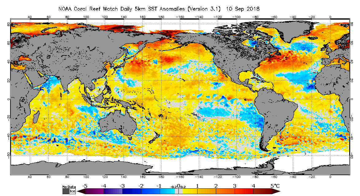
2018 had a -AMO-ish look to it near peak and look how that turned out. That was because of a strong WAM which is why we saw a good deal of MDR activity despite the SST pattern. So I don’t think we should solely focus on the AMO as the indicator for later in the season, as 2018 taught us.
Image
3 likes   

User avatar
CyclonicFury
Category 5
Category 5
Posts: 1977
Age: 25
Joined: Sun Jul 02, 2017 12:32 pm
Location: NC
Contact:

Re: 2020 Indicators: SST's / SAL / MSLP / Steering / Shear / Instability / Sat Images

#1232 Postby CyclonicFury » Tue Jun 30, 2020 10:50 am

Shell Mound wrote:According to data from ESRL’s NCEP/NCAR SST reanalysis, the AMO in June ‘20 has been cooler than in June ‘17, owing to greater North Atlantic Deep Water (NADW) penetration. This is why slight changes in the synoptic pattern produce significant ± fluctuations in SSTs across the North Atlantic basin, given the presence of very cold subsurface waters in the eastern subtropics and far North Atlantic. I’m still uncertain as to whether cool neutral ENSO and a strong WAM/AEJ will be sufficient to overcome the rather anaemic state of the AMO. The AMO, to me, is the biggest potential negative factor that could hinder the 2020 Atlantic hurricane season, not the SAL. Only one and a half week of ridging over the Northwestern Atlantic has been sufficient to eliminate well-below-average SSTs and build a massive warm pool off New England and the Mid-Atlantic region—a feature that is typical of a -AMO regime. This means that the subsurface over the Northwestern (Northeastern) Atlantic is very warm (cold) and easily reaches the surface as soon as low-level winds slacken (strengthen) and veer (back). I would pay more attention to the subsurface than the surface when gauging the state of the AMO. Even if the MDR/Caribbean have been mostly above average for most of June, the preponderance of cold NADW in the eastern subtropics/far North Atlantic means that as soon as trade winds strengthen, virtually all the warm SSTs vanish, as they have in just the past week. Now SSTs in the MDR/Caribbean are average to below average at best.

The MDR is still warmer than normal on most datasets, CDAS seems to have a cold bias during/after SAL outbreaks. It is warmer than 2018/19, seasons that managed above normal activity.
3 likes   
NCSU B.S. in Meteorology Class of 2021. Tropical weather blogger at http://www.cyclonicfury.com. My forecasts and thoughts are NOT official, for official forecasts please consult the National Hurricane Center.

User avatar
ScottNAtlanta
Category 5
Category 5
Posts: 2008
Joined: Sat May 25, 2013 3:11 pm
Location: Atlanta, GA

Re: 2020 Indicators: SST's / SAL / MSLP / Steering / Shear / Instability / Sat Images

#1233 Postby ScottNAtlanta » Tue Jun 30, 2020 1:14 pm

Image

Some things to look at...notice the water off southern Brazil. That cold anomaly that showed up in the spring is gone. That is a favorable signal of a positive AMM . The cool GOG in the eastern equatorial Atlantic promotes more precipitation in the Western African Sahel, thus enhances the Western African Monsoon. Bigger wave train. The dust we have seen is a product of the stronger waves we are seeing.
6 likes   
The posts in this forum are NOT official forecast and should not be used as such. They are just the opinion of the poster and may or may not be backed by sound meteorological data. They are NOT endorsed by any professional institution or storm2k.org. For official information, please refer to the NHC and NWS products.

User avatar
cycloneye
Admin
Admin
Posts: 139479
Age: 67
Joined: Thu Oct 10, 2002 10:54 am
Location: San Juan, Puerto Rico

Re: 2020 Indicators: SST's / SAL / MSLP / Steering / Shear / Instability / Sat Images

#1234 Postby cycloneye » Tue Jun 30, 2020 4:02 pm

1 likes   
Visit the Caribbean-Central America Weather Thread where you can find at first post web cams,radars
and observations from Caribbean basin members Click Here

User avatar
aspen
Category 5
Category 5
Posts: 8059
Joined: Sat Oct 12, 2019 7:10 pm
Location: Connecticut, USA

Re: 2020 Indicators: SST's / SAL / MSLP / Steering / Shear / Instability / Sat Images

#1235 Postby aspen » Tue Jun 30, 2020 4:16 pm


How do +/-IODs impact Atlantic hurricane season activity? In this situation, would a +IOD help or hamper MDR activity?
0 likes   
Irene '11 Sandy '12 Hermine '16 5/15/2018 Derecho Fay '20 Isaias '20 Elsa '21 Henri '21 Ida '21

I am only a meteorology enthusiast who knows a decent amount about tropical cyclones. Look to the professional mets, the NHC, or your local weather office for the best information.

User avatar
Ubuntwo
Category 5
Category 5
Posts: 1089
Age: 30
Joined: Thu Oct 05, 2017 10:41 pm

Re: 2020 Indicators: SST's / SAL / MSLP / Steering / Shear / Instability / Sat Images

#1236 Postby Ubuntwo » Tue Jun 30, 2020 4:37 pm

aspen wrote:

How do +/-IODs impact Atlantic hurricane season activity? In this situation, would a +IOD help or hamper MDR activity?

I think the direct influence on the Atlantic hurricane season is poorly studied. However, with increased rainfall over East Africa and reduced SSTs over the far western Pacific, a +IOD would be tangentially tied to increased activity. Nothing major though.
2 likes   
Kendall -> SLO -> PBC

Memorable Storms: Katrina (for its Florida landfall...) Wilma Matthew Irma

USTropics
Category 5
Category 5
Posts: 2420
Joined: Sun Aug 12, 2007 3:45 am
Location: Florida State University

Re: 2020 Indicators: SST's / SAL / MSLP / Steering / Shear / Instability / Sat Images

#1237 Postby USTropics » Tue Jun 30, 2020 4:44 pm

aspen wrote:

How do +/-IODs impact Atlantic hurricane season activity? In this situation, would a +IOD help or hamper MDR activity?


There is some debate over the connection between IOD and ENSO, but essentially the +/- mode of the IOD can hinder or propel atmospheric changes during ENSO transitions. For instance, a + IOD increases Pacific trade winds, promotes La Nina, and strengthens the Walker circulation. A - IOD creates weaker trade winds, promotes El Nino, and weakens the Walker circulation. So basically the chain is:

positive IOD --> cooling ENSO (La Nina) --> enhanced Walker circulation --> more active Atlantic
negative IOD --> warming ENSO (El Nino) --> weakened Walker circulation --> less active Atlantic
2 likes   

User avatar
CyclonicFury
Category 5
Category 5
Posts: 1977
Age: 25
Joined: Sun Jul 02, 2017 12:32 pm
Location: NC
Contact:

Re: 2020 Indicators: SST's / SAL / MSLP / Steering / Shear / Instability / Sat Images

#1238 Postby CyclonicFury » Tue Jun 30, 2020 4:49 pm

USTropics wrote:
aspen wrote:

How do +/-IODs impact Atlantic hurricane season activity? In this situation, would a +IOD help or hamper MDR activity?


There is some debate over the connection between IOD and ENSO, but essentially the +/- mode of the IOD can hinder or propel atmospheric changes during ENSO transitions. For instance, a + IOD increases Pacific trade winds, promotes La Nina, and strengthens the Walker circulation. A - IOD creates weaker trade winds, promotes El Nino, and weakens the Walker circulation. So basically the chain is:

positive IOD --> cooling ENSO (La Nina) --> enhanced Walker circulation --> more active Atlantic
negative IOD --> warming ENSO (El Nino) --> weakened Walker circulation --> less active Atlantic

I thought it was the other way around, doesn't a -IOD favor upward motion over the Maritime Continent, which is more La Niña like, while a +IOD favors sinking over this region?
2 likes   
NCSU B.S. in Meteorology Class of 2021. Tropical weather blogger at http://www.cyclonicfury.com. My forecasts and thoughts are NOT official, for official forecasts please consult the National Hurricane Center.

User avatar
cycloneye
Admin
Admin
Posts: 139479
Age: 67
Joined: Thu Oct 10, 2002 10:54 am
Location: San Juan, Puerto Rico

Re: 2020 Indicators: SST's / SAL / MSLP / Steering / Shear / Instability / Sat Images

#1239 Postby cycloneye » Tue Jun 30, 2020 4:51 pm

CyclonicFury wrote:
USTropics wrote:
aspen wrote:How do +/-IODs impact Atlantic hurricane season activity? In this situation, would a +IOD help or hamper MDR activity?


There is some debate over the connection between IOD and ENSO, but essentially the +/- mode of the IOD can hinder or propel atmospheric changes during ENSO transitions. For instance, a + IOD increases Pacific trade winds, promotes La Nina, and strengthens the Walker circulation. A - IOD creates weaker trade winds, promotes El Nino, and weakens the Walker circulation. So basically the chain is:

positive IOD --> cooling ENSO (La Nina) --> enhanced Walker circulation --> more active Atlantic
negative IOD --> warming ENSO (El Nino) --> weakened Walker circulation --> less active Atlantic

I thought it was the other way around, doesn't a -IOD favor upward motion over the Maritime Continent, which is more La Niña like, while a +IOD favors sinking over this region?


Well,no consensus here.
0 likes   
Visit the Caribbean-Central America Weather Thread where you can find at first post web cams,radars
and observations from Caribbean basin members Click Here

User avatar
cycloneye
Admin
Admin
Posts: 139479
Age: 67
Joined: Thu Oct 10, 2002 10:54 am
Location: San Juan, Puerto Rico

Re: 2020 Indicators: SST's / SAL / MSLP / Steering / Shear / Instability / Sat Images

#1240 Postby cycloneye » Tue Jun 30, 2020 5:15 pm

0 likes   
Visit the Caribbean-Central America Weather Thread where you can find at first post web cams,radars
and observations from Caribbean basin members Click Here


Return to “Talkin' Tropics”

Who is online

Users browsing this forum: Google [Bot], kevin, Stratton23, WAcyclone and 22 guests