
UL conditions look good for something to develop and strengthen in the GoM mid next week.
More models jumping on this.
2021 Global Model Runs Discussion (Out thru day 16)
Moderator: S2k Moderators
Forum rules

The posts in this forum are NOT official forecasts and should not be used as such. They are just the opinion of the poster and may or may not be backed by sound meteorological data. They are NOT endorsed by any professional institution or STORM2K. For official information, please refer to products from the National Hurricane Center and National Weather Service.
-
Blown Away

- S2K Supporter

- Posts: 10253
- Joined: Wed May 26, 2004 6:17 am
Re: 2021 Global Model Runs Discussion (Out thru day 16)
GCANE wrote:UL conditions look good for something to develop and strengthen in the GoM mid next week.
More models jumping on this.
Besides Larry, GOM seems like only location up to @Septmeber 20 for development. Nothing much spinning up on the models in the MDR besides Larry in next 16 days, so that puts us near Sept 20th and its very rare for a system from the east to strike CONUS after Sept 20th. Models not showing much activity for the heart of the season, except a few weak lows here and there.
1 likes
Hurricane Eye Experience: David 79, Irene 99, Frances 04, Jeanne 04, Wilma 05… Hurricane Brush Experience: Andrew 92, Erin 95, Floyd 99, Matthew 16, Irma 17, Ian 22, Nicole 22…
-
SFLcane

- S2K Supporter
- Posts: 10281
- Age: 48
- Joined: Sat Jun 05, 2010 1:44 pm
- Location: Lake Worth Florida
Re: 2021 Global Model Runs Discussion (Out thru day 16)
Euro ensembles still showing a rather strong long range signal for 1-2 tc’s across the main development region. I certainly think this is attainable. Steering is also quite worrisome if something we’re to develop.
4 likes
Re: 2021 Global Model Runs Discussion (Out thru day 16)
Blown Away wrote:GCANE wrote:UL conditions look good for something to develop and strengthen in the GoM mid next week.
More models jumping on this.
Besides Larry, GOM seems like only location up to @Septmeber 20 for development. Nothing much spinning up on the models in the MDR besides Larry in next 16 days, so that puts us near Sept 20th and its very rare for a system from the east to strike CONUS after Sept 20th. Models not showing much activity for the heart of the season, except a few weak lows here and there.
Have you seen the last few days of Euro op and ensemble? They both have been showing a strong signal for 1-2 TCs to form in the eastern MDR starting ~9/11. The last 3 Euro op runs have literally shown a TS there.
3 likes
Personal Forecast Disclaimer:
The posts in this forum are NOT official forecasts and should not be used as such. They are just the opinion of the poster and may or may not be backed by sound meteorological data. They are NOT endorsed by any professional institution or storm2k.org. For official information, please refer to the NHC and NWS products.
The posts in this forum are NOT official forecasts and should not be used as such. They are just the opinion of the poster and may or may not be backed by sound meteorological data. They are NOT endorsed by any professional institution or storm2k.org. For official information, please refer to the NHC and NWS products.
-
jconsor
- Professional-Met

- Posts: 573
- Joined: Mon Jun 30, 2008 9:31 pm
- Location: Jerusalem, Israel
- Contact:
Re: 2021 Global Model Runs Discussion (Out thru day 16)
Besides the potential GOM system next week, I would watch the western Caribbean late next week into next weekend.
https://twitter.com/yconsor/status/1433798234196094979
https://twitter.com/yconsor/status/1433800123444776966
https://twitter.com/yconsor/status/1433798234196094979
https://twitter.com/yconsor/status/1433800123444776966
6 likes

Re: 2021 Global Model Runs Discussion (Out thru day 16)
Category5Kaiju wrote:From the possible Gulf system to the wave behind Larry, I am not sure if calling for an inactive September is going to pan out well as model support does exist for both possible AOIs. September imho is far from dead.
Have people called for an inactive September or just lesser activity early September (except Larry obviously) as compared to the most recent MJO & CCKW burst that spawned several invests and named storms? That’s all I was suggesting anyway and not sure if someone else was calling for that.
1 likes
Re: 2021 Global Model Runs Discussion (Out thru day 16)
Consistent with the prior 3 Euro runs, the 12Z Euro yet again has a TS just off Africa that originates from an AEW that comes off ~9/11. But this time it comes off quite far north (near 20N) and thus easily recurves just offshore.
0 likes
Personal Forecast Disclaimer:
The posts in this forum are NOT official forecasts and should not be used as such. They are just the opinion of the poster and may or may not be backed by sound meteorological data. They are NOT endorsed by any professional institution or storm2k.org. For official information, please refer to the NHC and NWS products.
The posts in this forum are NOT official forecasts and should not be used as such. They are just the opinion of the poster and may or may not be backed by sound meteorological data. They are NOT endorsed by any professional institution or storm2k.org. For official information, please refer to the NHC and NWS products.
-
SFLcane
- S2K Supporter
- Posts: 10281
- Age: 48
- Joined: Sat Jun 05, 2010 1:44 pm
- Location: Lake Worth Florida
Re: 2021 Global Model Runs Discussion (Out thru day 16)
LarryWx wrote:Consistent with the prior 3 Euro runs, the 12Z Euro yet again has a TS just off Africa that originates from an AEW that comes off ~9/11. But this time it comes off quite far north (near 20N) and thus easily recurves just offshore.
That’s just ridiculous! Near 21n? Bias in full affect though the eastern Atlantic ridge is weaker.
0 likes
-
cycloneye

- Admin

- Posts: 149014
- Age: 69
- Joined: Thu Oct 10, 2002 10:54 am
- Location: San Juan, Puerto Rico
Re: 2021 Global Model Runs Discussion (Out thru day 16)
12z Euro does not have anything of interest between Africa and Lesser Antilles.

0 likes
Visit the Caribbean-Central America Weather Thread where you can find at first post web cams,radars
and observations from Caribbean basin members Click Here
and observations from Caribbean basin members Click Here
Re: 2021 Global Model Runs Discussion (Out thru day 16)
SFLcane wrote:LarryWx wrote:Consistent with the prior 3 Euro runs, the 12Z Euro yet again has a TS just off Africa that originates from an AEW that comes off ~9/11. But this time it comes off quite far north (near 20N) and thus easily recurves just offshore.
That’s just ridiculous! Near 21n? Bias in full affect though the eastern Atlantic ridge is weaker.
I couldn't find even a single TC track back to 1851 just off Africa that far north. Almost all are 16N or further south. So, it looks bogus.
1 likes
Personal Forecast Disclaimer:
The posts in this forum are NOT official forecasts and should not be used as such. They are just the opinion of the poster and may or may not be backed by sound meteorological data. They are NOT endorsed by any professional institution or storm2k.org. For official information, please refer to the NHC and NWS products.
The posts in this forum are NOT official forecasts and should not be used as such. They are just the opinion of the poster and may or may not be backed by sound meteorological data. They are NOT endorsed by any professional institution or storm2k.org. For official information, please refer to the NHC and NWS products.
Re: 2021 Global Model Runs Discussion (Out thru day 16)
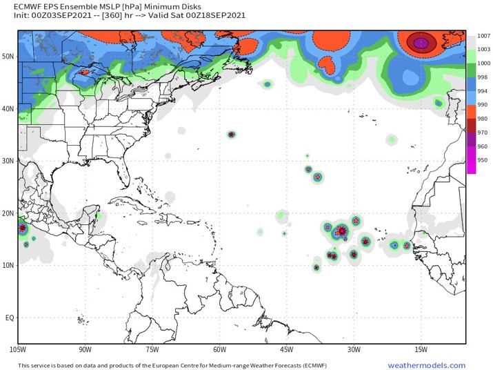
12Z EPS at 360: most of these are originating from a followup wave after the 9/11 one and almost all of these are moving pretty rapidly due W or just N of due W 

12Z EPS H5 at 360 has strong ridging to the north allowing for pretty rapid movement W or just N of due W:

12Z EPS H5 at 360 has strong ridging to the north allowing for pretty rapid movement W or just N of due W:
4 likes
Personal Forecast Disclaimer:
The posts in this forum are NOT official forecasts and should not be used as such. They are just the opinion of the poster and may or may not be backed by sound meteorological data. They are NOT endorsed by any professional institution or storm2k.org. For official information, please refer to the NHC and NWS products.
The posts in this forum are NOT official forecasts and should not be used as such. They are just the opinion of the poster and may or may not be backed by sound meteorological data. They are NOT endorsed by any professional institution or storm2k.org. For official information, please refer to the NHC and NWS products.
-
SFLcane
- S2K Supporter
- Posts: 10281
- Age: 48
- Joined: Sat Jun 05, 2010 1:44 pm
- Location: Lake Worth Florida
Re: 2021 Global Model Runs Discussion (Out thru day 16)
LarryWx wrote:12Z EPS at 360: most of these are originating from a followup wave after the 9/11 one and almost all of these are moving pretty rapidly due W or just N of due W
https://i.imgur.com/g7F0K39.png
12Z EPS H5 at 360 has strong ridging to the north allowing for pretty rapid movement W or just N of due W:
https://i.imgur.com/9A2QxnB.png
Larry, Seems hard to believe ridging would hold across the entire Atlantic at that point. But we will see
1 likes
Re: 2021 Global Model Runs Discussion (Out thru day 16)
SFLcane wrote:LarryWx wrote:12Z EPS at 360: most of these are originating from a followup wave after the 9/11 one and almost all of these are moving pretty rapidly due W or just N of due W
https://i.imgur.com/g7F0K39.png
12Z EPS H5 at 360 has strong ridging to the north allowing for pretty rapid movement W or just N of due W:
https://i.imgur.com/9A2QxnB.png
Larry, Seems hard to believe ridging would hold across the entire Atlantic at that point. But we will see
Good point as it usually doesn't. Instead, what often happens is that there is a weakness mid-ocean followed by a handoff to a redeveloping WAR. That's what can be very dangerous, especially in La Nina.
2 likes
Personal Forecast Disclaimer:
The posts in this forum are NOT official forecasts and should not be used as such. They are just the opinion of the poster and may or may not be backed by sound meteorological data. They are NOT endorsed by any professional institution or storm2k.org. For official information, please refer to the NHC and NWS products.
The posts in this forum are NOT official forecasts and should not be used as such. They are just the opinion of the poster and may or may not be backed by sound meteorological data. They are NOT endorsed by any professional institution or storm2k.org. For official information, please refer to the NHC and NWS products.
-
SFLcane
- S2K Supporter
- Posts: 10281
- Age: 48
- Joined: Sat Jun 05, 2010 1:44 pm
- Location: Lake Worth Florida
Re: 2021 Global Model Runs Discussion (Out thru day 16)
LarryWx wrote:SFLcane wrote:LarryWx wrote:12Z EPS at 360: most of these are originating from a followup wave after the 9/11 one and almost all of these are moving pretty rapidly due W or just N of due W
https://i.imgur.com/g7F0K39.png
12Z EPS H5 at 360 has strong ridging to the north allowing for pretty rapid movement W or just N of due W:
https://i.imgur.com/9A2QxnB.png
Larry, Seems hard to believe ridging would hold across the entire Atlantic at that point. But we will see
Good point as it usually doesn't. Instead, what often happens is that there is a weakness mid-ocean followed by a handoff to a redeveloping WAR. That's what can be very dangerous, especially in La Nina.
Quite interesting. I guess we’ll see
0 likes
-
SFLcane
- S2K Supporter
- Posts: 10281
- Age: 48
- Joined: Sat Jun 05, 2010 1:44 pm
- Location: Lake Worth Florida
Re: 2021 Global Model Runs Discussion (Out thru day 16)
LarryWx wrote:SFLcane wrote:LarryWx wrote:12Z EPS at 360: most of these are originating from a followup wave after the 9/11 one and almost all of these are moving pretty rapidly due W or just N of due W
https://i.imgur.com/g7F0K39.png
12Z EPS H5 at 360 has strong ridging to the north allowing for pretty rapid movement W or just N of due W:
https://i.imgur.com/9A2QxnB.png
Larry, Seems hard to believe ridging would hold across the entire Atlantic at that point. But we will see
Good point as it usually doesn't. Instead, what often happens is that there is a weakness mid-ocean followed by a handoff to a redeveloping WAR. That's what can be very dangerous, especially in La Nina.
Also Larry, I would think it Depends on where a TC is in relation.
1 likes
-
Blown Away
- S2K Supporter
- Posts: 10253
- Joined: Wed May 26, 2004 6:17 am
Re: 2021 Global Model Runs Discussion (Out thru day 16)

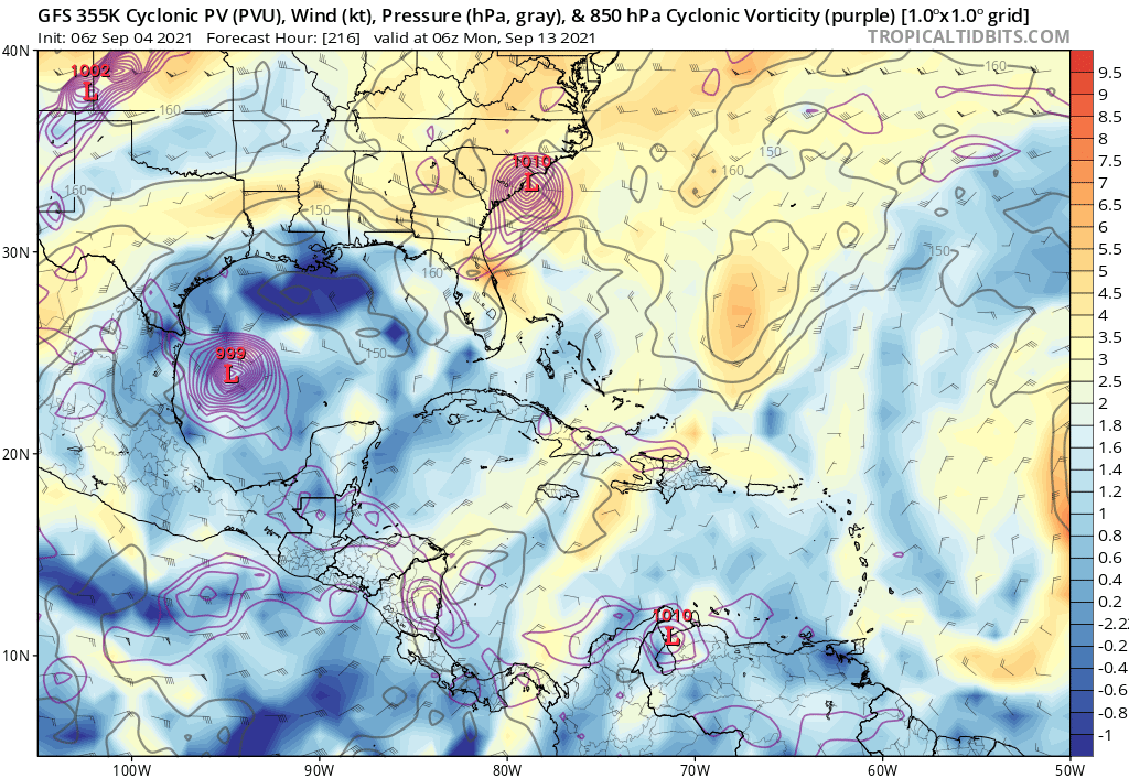
12z GFS has a few weak lows moving towards the CONUS late in the run.
1 likes
Hurricane Eye Experience: David 79, Irene 99, Frances 04, Jeanne 04, Wilma 05… Hurricane Brush Experience: Andrew 92, Erin 95, Floyd 99, Matthew 16, Irma 17, Ian 22, Nicole 22…


Re: 2021 Global Model Runs Discussion (Out thru day 16)
06z GFS develops 91L before landfall and has it regenerate a few days later over the Gulf Stream, becoming a hurricane. Meanwhile, a system begins forming in the WCar, crosses over the Yucatán, and proceeds to become a hurricane before landfall in Texas. All of this is within 10 days.
0 likes
Irene '11 Sandy '12 Hermine '16 5/15/2018 Derecho Fay '20 Isaias '20 Elsa '21 Henri '21 Ida '21
I am only a meteorology enthusiast who knows a decent amount about tropical cyclones. Look to the professional mets, the NHC, or your local weather office for the best information.
I am only a meteorology enthusiast who knows a decent amount about tropical cyclones. Look to the professional mets, the NHC, or your local weather office for the best information.
Re: 2021 Global Model Runs Discussion (Out thru day 16)
One week from Labor Day.
A potential deadly setup in the GoM
A potential deadly setup in the GoM
3 likes
Re: 2021 Global Model Runs Discussion (Out thru day 16)
This looks very viable.
Larry and 91L will be enhancing the amplitude of this wave as it travels along the north shore of South America and thru the Carib.
In the GoM, it'll hit a perfect ARWB.
Chronic high CAPE pool offshore Houston.
Also, a setup to pull massive high TPW air from the EPAC.
All the ingredients for a major and a disaster.
Let's hope it doesn't pan out that way.
1 likes
Re: 2021 Global Model Runs Discussion (Out thru day 16)
Tilt and location of the Rossby Wave spells a worst-case scenario not to mention high OHC and CAPE.
Hope future model runs paint a different picture.
Hope future model runs paint a different picture.
0 likes
Who is online
Users browsing this forum: pepecool20, Teban54 and 99 guests