2019 Tropics: Global Model Runs Discussion (Out to day 16)

This is the general tropical discussion area. Anyone can take their shot at predicting a storms path.

Moderator: S2k Moderators

Forum rules

The posts in this forum are NOT official forecasts and should not be used as such. They are just the opinion of the poster and may or may not be backed by sound meteorological data. They are NOT endorsed by any professional institution or STORM2K. For official information, please refer to products from the National Hurricane Center and National Weather Service.

Help Support Storm2K
Message
Author
User avatar
gatorcane
S2K Supporter
S2K Supporter
Posts: 23499
Age: 46
Joined: Sun Mar 13, 2005 3:54 pm
Location: Boca Raton, FL

Re: 2019 Tropics: Global Model Runs Discussion (Out to day 16)

#141 Postby gatorcane » Wed Jul 03, 2019 6:06 pm

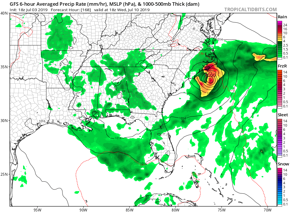
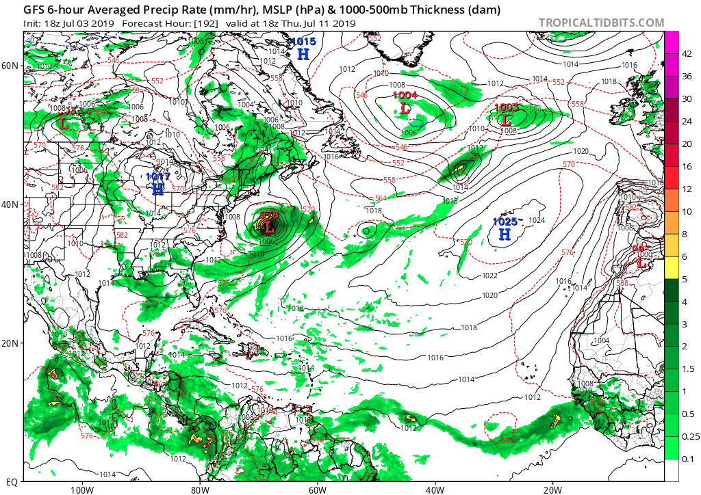
GFS with genesis days 6-7 rapidly developing this into a hurricane:

Image

Image
1 likes   

USTropics
Category 5
Category 5
Posts: 2420
Joined: Sun Aug 12, 2007 3:45 am
Location: Florida State University

Re: 2019 Tropics: Global Model Runs Discussion (Out to day 16)

#142 Postby USTropics » Wed Jul 03, 2019 6:38 pm

If the GFS is correct, we should see signs in the near future. Origins can be traced to the current frontal boundary stalled in the Midwest. Surface analysis forecasts show a shortwave trough cutting off in 24-36 hours just north of Texas that moves around the periphery of the high pressure towards the EC:

Image

You can see this evolution in the 850mb vort loop below from the 18z run:
Image
1 likes   

User avatar
gatorcane
S2K Supporter
S2K Supporter
Posts: 23499
Age: 46
Joined: Sun Mar 13, 2005 3:54 pm
Location: Boca Raton, FL

Re: 2019 Tropics: Global Model Runs Discussion (Out to day 16)

#143 Postby gatorcane » Wed Jul 03, 2019 7:49 pm

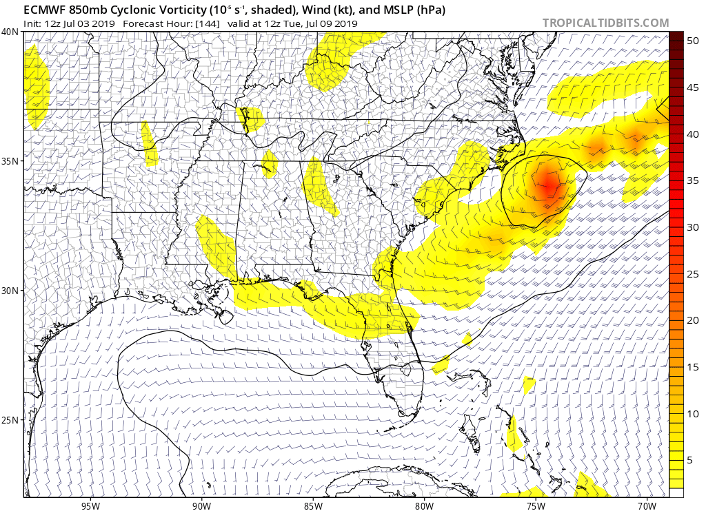
The Euro shows a similar evolution and path for the piece of energy that could spawn genesis. It is also possible we see some subtropical development. Looks to be a bit north of where the GFS has it at 144 hours:

Image
0 likes   

USTropics
Category 5
Category 5
Posts: 2420
Joined: Sun Aug 12, 2007 3:45 am
Location: Florida State University

Re: 2019 Tropics: Global Model Runs Discussion (Out to day 16)

#144 Postby USTropics » Wed Jul 03, 2019 8:04 pm

Seems the GFS digs the high pressure area further south than the ECMWF, resulting in a more SE motion as the shortwave trough rounds the periphery of the high pressure area. You can follow the vorticity of the shortwave trough with the high-res ECMWF run below. Subtle signs to watch for in the short-term to see which model has a more accurate grasp on the evolution.

Image
0 likes   

USTropics
Category 5
Category 5
Posts: 2420
Joined: Sun Aug 12, 2007 3:45 am
Location: Florida State University

Re: 2019 Tropics: Global Model Runs Discussion (Out to day 16)

#145 Postby USTropics » Wed Jul 03, 2019 8:17 pm

One other interesting note, the GFS has performed quite well in the last week or so when looking at anomaly correlations, catching up quickly with the ECMWF:

Image

Below is a model verification for the GFS, ECMWF, and UKMET as well in regards to 500mb heights (red lines are previous forecasts, blue is current analysis).

GFS:
Image

ECMWF:
Image

UKMET:
Image
2 likes   

User avatar
Hypercane_Kyle
Category 5
Category 5
Posts: 2900
Joined: Sat Mar 07, 2015 7:58 pm
Location: Cape Canaveral, FL

Re: 2019 Tropics: Global Model Runs Discussion (Out to day 16)

#146 Postby Hypercane_Kyle » Wed Jul 03, 2019 9:21 pm

Looks like this upcoming trough could spin 1-2 tropical cyclones up. GFS spins one up (Barry) by 144hrs, and another by 162hrs (Chantal).
1 likes   
My posts are my own personal opinion, defer to the National Hurricane Center (NHC) and other NOAA products for decision making during hurricane season.

User avatar
TheStormExpert
Category 5
Category 5
Posts: 8487
Age: 30
Joined: Wed Feb 16, 2011 5:38 pm
Location: Palm Beach Gardens, FL

Re: 2019 Tropics: Global Model Runs Discussion (Out to day 16)

#147 Postby TheStormExpert » Wed Jul 03, 2019 10:21 pm

Watch the Tropical Atlantic also in about a weeks time for a potential brief spin up.
1 likes   
The following post is NOT an official forecast and should not be used as such. It is just the opinion of the poster and may or may not be backed by sound meteorological data. It is NOT endorsed by storm2k.org.

User avatar
chaser1
S2K Supporter
S2K Supporter
Posts: 4717
Age: 63
Joined: Sat Oct 15, 2005 5:59 pm
Location: Longwood, Fl

Re: 2019 Tropics: Global Model Runs Discussion (Out to day 16)

#148 Postby chaser1 » Thu Jul 04, 2019 9:57 am

TheStormExpert wrote:Watch the Tropical Atlantic also in about a weeks time for a potential brief spin up.


Looking at the 850 mb GFS, there does appear to be an increase of vorticity showing up with a few tropical waves to move off the African coast during the upcoming couple of weeks. While the ITCZ does look to become a bit more active in the E. Atlantic, surface pressures still appear to be high out there for the time being. The only thing I see trying to briefly spin up that NHC has lately developed a keen interest in, might be a small T.F. (Tropical Farce) that might develop along a weak frontal boundary east of the Carolina's. Perhaps it might offer a brief 12/24 warm core with just enough convection to excite the powers that be to tag it with a name.
1 likes   
Personal Forecast Disclaimer:
The posts in this forum are NOT official forecast and should not be used as such. They are just the opinion of the poster and may or may not be backed by sound meteorological data. They are NOT endorsed by any professional institution or storm2k.org. For official information, please refer to the NHC and NWS products.


User avatar
Hypercane_Kyle
Category 5
Category 5
Posts: 2900
Joined: Sat Mar 07, 2015 7:58 pm
Location: Cape Canaveral, FL

Re: 2019 Tropics: Global Model Runs Discussion (Out to day 16)

#149 Postby Hypercane_Kyle » Thu Jul 04, 2019 10:44 am

00z ECMWF has a TC over the GA/SC border by 240 hours.
Last edited by Hypercane_Kyle on Thu Jul 04, 2019 11:14 am, edited 1 time in total.
0 likes   
My posts are my own personal opinion, defer to the National Hurricane Center (NHC) and other NOAA products for decision making during hurricane season.

User avatar
drezee
S2K Supporter
S2K Supporter
Posts: 3644
Joined: Mon Jun 09, 2003 12:49 pm
Location: FL

Re: 2019 Tropics: Global Model Runs Discussion (Out to day 16)

#150 Postby drezee » Thu Jul 04, 2019 11:00 am

0 likes   

USTropics
Category 5
Category 5
Posts: 2420
Joined: Sun Aug 12, 2007 3:45 am
Location: Florida State University

Re: 2019 Tropics: Global Model Runs Discussion (Out to day 16)

#151 Postby USTropics » Thu Jul 04, 2019 11:10 am

Hypercane_Kyle wrote:12z ECMWF has a TC over the GA/SC border by 240 hours.


I believe that was last night's 00z run, still a few hours away from the 12z run for today. GFS just started running. Last night's 00z ECMWF run at 240 hrs:

Image
0 likes   

User avatar
Hypercane_Kyle
Category 5
Category 5
Posts: 2900
Joined: Sat Mar 07, 2015 7:58 pm
Location: Cape Canaveral, FL

Re: 2019 Tropics: Global Model Runs Discussion (Out to day 16)

#152 Postby Hypercane_Kyle » Thu Jul 04, 2019 11:14 am

USTropics wrote:
Hypercane_Kyle wrote:12z ECMWF has a TC over the GA/SC border by 240 hours.


I believe that was last night's 00z run, still a few hours away from the 12z run for today. GFS just started running. Last night's 00z ECMWF run at 240 hrs:

https://i.imgur.com/Khu1sHb.png


Was a typo on my part. Edited.
0 likes   
My posts are my own personal opinion, defer to the National Hurricane Center (NHC) and other NOAA products for decision making during hurricane season.

USTropics
Category 5
Category 5
Posts: 2420
Joined: Sun Aug 12, 2007 3:45 am
Location: Florida State University

Re: 2019 Tropics: Global Model Runs Discussion (Out to day 16)

#153 Postby USTropics » Thu Jul 04, 2019 11:40 am

The past few ECMWF and GFS runs are in close agreement with the evolution of a shortwave trough breaking off from the frontal boundary over the Midwest in the next 24 hours and driving it SE around the periphery of the high pressure system towards GA and the EC. The models have bounced around as to the strength, with the 12z GFS forecasting a weaker shortwave trough stalling over GA/SC before becoming elongated and stretched out. The tail end extends into the GOM in the long range, where a weak vort signature develops. Below is a loop of this evolution:

Image
4 likes   

USTropics
Category 5
Category 5
Posts: 2420
Joined: Sun Aug 12, 2007 3:45 am
Location: Florida State University

Re: 2019 Tropics: Global Model Runs Discussion (Out to day 16)

#154 Postby USTropics » Thu Jul 04, 2019 1:47 pm

The 12z ECMWF run almost mirrors the 12z GFS run, see loop below:

Image
1 likes   

User avatar
StruThiO
Category 3
Category 3
Posts: 821
Age: 24
Joined: Fri Sep 15, 2017 5:51 am
Location: Currently Portland, OR. Raised in Jax, FL.

Re: 2019 Tropics: Global Model Runs Discussion (Out to day 16)

#155 Postby StruThiO » Thu Jul 04, 2019 2:14 pm

1 likes   

User avatar
northjaxpro
S2K Supporter
S2K Supporter
Posts: 8900
Joined: Mon Sep 27, 2010 11:21 am
Location: Jacksonville, FL

Re: 2019 Tropics: Global Model Runs Discussion (Out to day 16)

#156 Postby northjaxpro » Thu Jul 04, 2019 2:53 pm

I would tend to think that if we see some type of home-grown development in the next week, I like the EURO's thinking of something possibly getting triggered in the ĢOM. GFS definitely showing different scenario with the short wave trough. We will watch and see how this plays out . Meanwhile, definitely nothing coming from out in the Tropical Atlantic anytime soon with SAL continuing to keep a lid on things out there.
Last edited by northjaxpro on Thu Jul 04, 2019 3:25 pm, edited 1 time in total.
0 likes   
NEVER, EVER SAY NEVER in the tropics and weather in general, and most importantly, with life itself!!

________________________________________________________________________________________

Fay 2008 Beryl 2012 Debby 2012 Colin 2016 Hermine 2016 Julia 2016 Matthew 2016 Irma 2017 Dorian 2019

jconsor
Professional-Met
Professional-Met
Posts: 532
Joined: Mon Jun 30, 2008 9:31 pm
Location: Jerusalem, Israel
Contact:

Re: 2019 Tropics: Global Model Runs Discussion (Out to day 16)

#157 Postby jconsor » Thu Jul 04, 2019 3:18 pm

1 likes   

User avatar
northjaxpro
S2K Supporter
S2K Supporter
Posts: 8900
Joined: Mon Sep 27, 2010 11:21 am
Location: Jacksonville, FL

Re: 2019 Tropics: Global Model Runs Discussion (Out to day 16)

#158 Postby northjaxpro » Thu Jul 04, 2019 3:22 pm


Well timed post after mine. This is the main reason and factor why I like the EURO's potential GOM scenario. SST's are extremely warm in the GOM currently. We will have to watch this potential very carefully next week!.
3 likes   
NEVER, EVER SAY NEVER in the tropics and weather in general, and most importantly, with life itself!!

________________________________________________________________________________________

Fay 2008 Beryl 2012 Debby 2012 Colin 2016 Hermine 2016 Julia 2016 Matthew 2016 Irma 2017 Dorian 2019

User avatar
gatorcane
S2K Supporter
S2K Supporter
Posts: 23499
Age: 46
Joined: Sun Mar 13, 2005 3:54 pm
Location: Boca Raton, FL

Re: 2019 Tropics: Global Model Runs Discussion (Out to day 16)

#159 Postby gatorcane » Thu Jul 04, 2019 3:37 pm

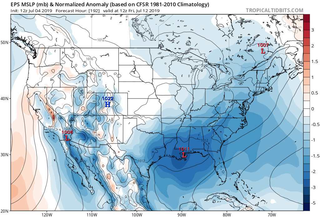
Euro ensemble mean showing lowering of pressure along the northern Gulf coast. Looks like the mean is more west than the op run:

Image
1 likes   

User avatar
TheStormExpert
Category 5
Category 5
Posts: 8487
Age: 30
Joined: Wed Feb 16, 2011 5:38 pm
Location: Palm Beach Gardens, FL

Re: 2019 Tropics: Global Model Runs Discussion (Out to day 16)

#160 Postby TheStormExpert » Thu Jul 04, 2019 3:52 pm

Background state should become more favorable for GoM tropical shenanigans next week.

 https://twitter.com/michaelrlowry/status/1146878670944047104


0 likes   
The following post is NOT an official forecast and should not be used as such. It is just the opinion of the poster and may or may not be backed by sound meteorological data. It is NOT endorsed by storm2k.org.


Return to “Talkin' Tropics”

Who is online

Users browsing this forum: Gums, JetFuel_SE, Landy, Lizzytiz1 and 46 guests