2017 Global Model Runs Discussion (Out to day 16)
Moderator: S2k Moderators
Forum rules

The posts in this forum are NOT official forecasts and should not be used as such. They are just the opinion of the poster and may or may not be backed by sound meteorological data. They are NOT endorsed by any professional institution or STORM2K. For official information, please refer to products from the National Hurricane Center and National Weather Service.
Re: 2017 Global Model Runs Discussion (Out to day 16)
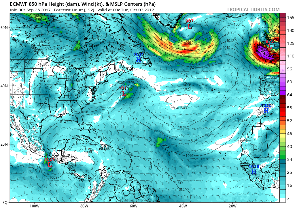
By 10/3 the GFS has an early polar high moving SE towards the GC, and if true when that 1028 high moves east, that would impact anything to our south...
0 likes
Re: 2017 Global Model Runs Discussion (Out to day 16)
Frank2 wrote:By 10/3 the GFS has an early polar high moving SE towards the GC, and if true when that 1028 high moves east, that would impact anything to our south...
Frank,
Please clarify what you mean. Thanks.
0 likes
Personal Forecast Disclaimer:
The posts in this forum are NOT official forecasts and should not be used as such. They are just the opinion of the poster and may or may not be backed by sound meteorological data. They are NOT endorsed by any professional institution or storm2k.org. For official information, please refer to the NHC and NWS products.
The posts in this forum are NOT official forecasts and should not be used as such. They are just the opinion of the poster and may or may not be backed by sound meteorological data. They are NOT endorsed by any professional institution or storm2k.org. For official information, please refer to the NHC and NWS products.
-
otowntiger
- Category 5

- Posts: 1787
- Joined: Tue Aug 31, 2004 7:06 pm
- Location: Orlando
Re: 2017 Global Model Runs Discussion (Out to day 16)
LarryWx wrote:Frank2 wrote:By 10/3 the GFS has an early polar high moving SE towards the GC, and if true when that 1028 high moves east, that would impact anything to our south...
Frank,
Please clarify what you mean. Thanks.
I presume that means the high pressure would be bringing cool stable air to the coast and blunting anything tropical like a force field away and sharply to the east.
0 likes
-
floridasun78
- Category 5
- Posts: 3755
- Joined: Sun May 17, 2009 10:16 pm
- Location: miami fl
Re: 2017 Global Model Runs Discussion (Out to day 16)
you think by wed we see circle in outlook in nw Caribbean or se Caribbean?
0 likes
Re: 2017 Global Model Runs Discussion (Out to day 16)
Frank2 wrote:By 10/3 the GFS has an early polar high moving SE towards the GC, and if true when that 1028 high moves east, that would impact anything to our south...
The CPC 6-10 and 8-14 day outlooks both show the combo of above normal temps and precip over florida. In fact the 8-14 day shows above normal temp anomalies returning to the entire eastern US. The current shot of fall temps that is about to cool off the east (and ultimately kick Maria out to sea) appears as if it will not make it to Florida. It will at least briefly make it into the deep south. If anything, the evolving pattern seems to favor future mischief rather than mitigating it. As always it's subject to change but it provides no comfort at this point imo.
3 likes
-
toad strangler

- S2K Supporter

- Posts: 4174
- Joined: Sun Jul 28, 2013 3:09 pm
- Location: Earth
- Contact:
Re: 2017 Global Model Runs Discussion (Out to day 16)
Trying to decipher some of these posts IRT the GFS is like a riddle and I'm a pretty proficient amateur...
What I see is the GFS overall is stuck in truncated far off fantasy timeframe with any potential development and refuses to move up in time for the last 5 days really.
What I see is the GFS overall is stuck in truncated far off fantasy timeframe with any potential development and refuses to move up in time for the last 5 days really.
0 likes
Re: 2017 Global Model Runs Discussion (Out to day 16)
floridasun78 wrote:you think by wed we see circle in outlook in nw Caribbean or se Caribbean?
If the EPS runs continue to suggest increased chances and if all GEFS runs (not just 18Z) become active, I'd go with a circle by Fri or Sat. Wed might be too early.
0 likes
Personal Forecast Disclaimer:
The posts in this forum are NOT official forecasts and should not be used as such. They are just the opinion of the poster and may or may not be backed by sound meteorological data. They are NOT endorsed by any professional institution or storm2k.org. For official information, please refer to the NHC and NWS products.
The posts in this forum are NOT official forecasts and should not be used as such. They are just the opinion of the poster and may or may not be backed by sound meteorological data. They are NOT endorsed by any professional institution or storm2k.org. For official information, please refer to the NHC and NWS products.
Re: 2017 Global Model Runs Discussion (Out to day 16)
otowntiger wrote:LarryWx wrote:Frank2 wrote:By 10/3 the GFS has an early polar high moving SE towards the GC, and if true when that 1028 high moves east, that would impact anything to our south...
Frank,
Please clarify what you mean. Thanks.
I presume that means the high pressure would be bringing cool stable air to the coast and blunting anything tropical like a force field away and sharply to the east.
I don't think it is nearly that simple. Nor do I think a big Canadian high coming down necessarily acts like a force field.
0 likes
Personal Forecast Disclaimer:
The posts in this forum are NOT official forecasts and should not be used as such. They are just the opinion of the poster and may or may not be backed by sound meteorological data. They are NOT endorsed by any professional institution or storm2k.org. For official information, please refer to the NHC and NWS products.
The posts in this forum are NOT official forecasts and should not be used as such. They are just the opinion of the poster and may or may not be backed by sound meteorological data. They are NOT endorsed by any professional institution or storm2k.org. For official information, please refer to the NHC and NWS products.
Re: 2017 Global Model Runs Discussion (Out to day 16)
toad strangler wrote:Trying to decipher some of these posts IRT the GFS is like a riddle and I'm a pretty proficient amateur...
What I see is the GFS overall is stuck in truncated far off fantasy timeframe with any potential development and refuses to move up in time for the last 5 days really.
Are you referring to my GEFS posts by chance?
0 likes
Personal Forecast Disclaimer:
The posts in this forum are NOT official forecasts and should not be used as such. They are just the opinion of the poster and may or may not be backed by sound meteorological data. They are NOT endorsed by any professional institution or storm2k.org. For official information, please refer to the NHC and NWS products.
The posts in this forum are NOT official forecasts and should not be used as such. They are just the opinion of the poster and may or may not be backed by sound meteorological data. They are NOT endorsed by any professional institution or storm2k.org. For official information, please refer to the NHC and NWS products.
-
toad strangler
- S2K Supporter
- Posts: 4174
- Joined: Sun Jul 28, 2013 3:09 pm
- Location: Earth
- Contact:
Re: 2017 Global Model Runs Discussion (Out to day 16)
LarryWx wrote:toad strangler wrote:Trying to decipher some of these posts IRT the GFS is like a riddle and I'm a pretty proficient amateur...
What I see is the GFS overall is stuck in truncated far off fantasy timeframe with any potential development and refuses to move up in time for the last 5 days really.
Are you referring to my GEFS posts by chance?
Your reads are informative. I guess I'm just not on a level that allows understanding of where you are coming from. To me, the GFS for the past 3 and 4 days has been in a post truncated rut with development and won't budge.
0 likes
-
otowntiger
- Category 5
- Posts: 1787
- Joined: Tue Aug 31, 2004 7:06 pm
- Location: Orlando
Re: 2017 Global Model Runs Discussion (Out to day 16)
. Well obviously the overall setup could have a lot other factors at play and of course I'm not suggesting that I know this will happen. Just trying to answer what it could mean if a cold Canadian high did set up like Frank saw in one model. But yes a high pressure could act like a force field-of sorts I would think- the Bermuda high pressure does. Hurricanes are steered around it certainly not toward it.LarryWx wrote:otowntiger wrote:LarryWx wrote:
Frank,
Please clarify what you mean. Thanks.
I presume that means the high pressure would be bringing cool stable air to the coast and blunting anything tropical like a force field away and sharply to the east.
I don't think it is nearly that simple. Nor do I think a big Canadian high coming down necessarily acts like a force field.
0 likes
-
SFLcane

- S2K Supporter
- Posts: 9618
- Age: 46
- Joined: Sat Jun 05, 2010 1:44 pm
- Location: Lake Worth Florida
Re: 2017 Global Model Runs Discussion (Out to day 16)
06z drops development all together favoring the epac which I think is also a likely outcome.
0 likes
-
CourierPR

- Category 5
- Posts: 1325
- Age: 70
- Joined: Tue Aug 31, 2004 7:53 pm
- Location: Pompano Beach, Florida
Re: 2017 Global Model Runs Discussion (Out to day 16)
SFLcane wrote:06z drops development all together favoring the epac which I think is also a likely outcome.
You base your opinion off one model run and what other factors?
0 likes
-
SFLcane
- S2K Supporter
- Posts: 9618
- Age: 46
- Joined: Sat Jun 05, 2010 1:44 pm
- Location: Lake Worth Florida
Re: 2017 Global Model Runs Discussion (Out to day 16)
CourierPR wrote:SFLcane wrote:06z drops development all together favoring the epac which I think is also a likely outcome.
You base your opinion off one model run and what other factors?
Based solely this is still very long range and time has not been brought in. Conditions are favorable but it’s hard to pin point exactly were if any development could occur. Hoping it’s on epac we’ve had enough this season.
0 likes

Re: 2017 Global Model Runs Discussion (Out to day 16)
SFLcane wrote:06z drops development all together favoring the epac which I think is also a likely outcome.
not in a la nina
1 likes
-
tropicwatch

- Category 5
- Posts: 3205
- Age: 60
- Joined: Sat Jun 02, 2007 10:01 am
- Location: Panama City Florida
- Contact:
Re: 2017 Global Model Runs Discussion (Out to day 16)
06Z euro also showing EPAC.
0 likes
Tropicwatch
Agnes 72', Eloise 75, Elena 85', Kate 85', Charley 86', Florence 88', Beryl 94', Dean 95', Erin 95', Opal 95', Earl 98', Georges 98', Ivan 2004', Arlene 2005', Dennis 2005', Ida 2009' Debby 2012' Irma 2017' Michael 2018'
Agnes 72', Eloise 75, Elena 85', Kate 85', Charley 86', Florence 88', Beryl 94', Dean 95', Erin 95', Opal 95', Earl 98', Georges 98', Ivan 2004', Arlene 2005', Dennis 2005', Ida 2009' Debby 2012' Irma 2017' Michael 2018'
-
tolakram
- Admin

- Posts: 19172
- Age: 60
- Joined: Sun Aug 27, 2006 8:23 pm
- Location: Florence, KY (name is Mark)
Re: 2017 Global Model Runs Discussion (Out to day 16)
0Z Euro final frame shows vorticity in the Caribbean.

0 likes
M a r k
- - - - -
Join us in chat: Storm2K Chatroom Invite. Android and IOS apps also available.
The posts in this forum are NOT official forecasts and should not be used as such. Posts are NOT endorsed by any professional institution or STORM2K.org. For official information and forecasts, please refer to NHC and NWS products.

Re: 2017 Global Model Runs Discussion (Out to day 16)
Looks like a pretty classic CAG event. Wouldn't be surprised to see a TC in the EPac and Atlantic.
0 likes
-
otowntiger
- Category 5
- Posts: 1787
- Joined: Tue Aug 31, 2004 7:06 pm
- Location: Orlando
Re: 2017 Global Model Runs Discussion (Out to day 16)
What's 'CAG' stand for? thanks.RL3AO wrote:Looks like a pretty classic CAG event. Wouldn't be surprised to see a TC in the EPac and Atlantic.
0 likes
Re: 2017 Global Model Runs Discussion (Out to day 16)
CourierPR wrote:SFLcane wrote:06z drops development all together favoring the epac which I think is also a likely outcome.
You base your opinion off one model run and what other factors?
Not only that, but the 6Z currently seems to have a pretty significant anti-TC genesis bias in the western ATL basin. Looking at the GEFS, the 6Z has been the weakest of the 4 runs for many days now just as the 18Z has been the strongest/biased pro-TC development there. The 0Z/12Z appear to be the least biased of the GEFS.
Last edited by LarryWx on Mon Sep 25, 2017 8:08 am, edited 1 time in total.
0 likes
Personal Forecast Disclaimer:
The posts in this forum are NOT official forecasts and should not be used as such. They are just the opinion of the poster and may or may not be backed by sound meteorological data. They are NOT endorsed by any professional institution or storm2k.org. For official information, please refer to the NHC and NWS products.
The posts in this forum are NOT official forecasts and should not be used as such. They are just the opinion of the poster and may or may not be backed by sound meteorological data. They are NOT endorsed by any professional institution or storm2k.org. For official information, please refer to the NHC and NWS products.
Who is online
Users browsing this forum: cajungal, CFLHurricane, Google [Bot], jlauderdal, Jr0d, Stratton23 and 28 guests