2019 Tropics: Global Model Runs Discussion (Out to day 16)

This is the general tropical discussion area. Anyone can take their shot at predicting a storms path.

Moderator: S2k Moderators

Forum rules

The posts in this forum are NOT official forecasts and should not be used as such. They are just the opinion of the poster and may or may not be backed by sound meteorological data. They are NOT endorsed by any professional institution or STORM2K. For official information, please refer to products from the National Hurricane Center and National Weather Service.

Help Support Storm2K
Message
Author
User avatar
TheStormExpert
Category 5
Category 5
Posts: 8487
Age: 30
Joined: Wed Feb 16, 2011 5:38 pm
Location: Palm Beach Gardens, FL

Re: 2019 Tropics: Global Model Runs Discussion (Out to day 16)

#161 Postby TheStormExpert » Thu Jul 04, 2019 3:55 pm

northjaxpro wrote:I would tend to think that if we see some type of home-grown development in the next week, I like the EURO's thinking of something possibly getting triggered in the ĢOM. GFS definitely showing different scenario with the short wave trough. We will watch and see how this plays out . Meanwhile, definitely nothing coming from out in the Tropical Atlantic anytime soon with SAL continuing to keep a lid on things out there.

Speaking of the Tropical Atlantic, several recent GFS runs were starting to spark areas of low pressure and vortices in Tropical Atlantic as early as next week. Though like you said it’s likely too early and we shouldn’t expect another Beryl like last July.
1 likes   
The following post is NOT an official forecast and should not be used as such. It is just the opinion of the poster and may or may not be backed by sound meteorological data. It is NOT endorsed by storm2k.org.

User avatar
StruThiO
Category 3
Category 3
Posts: 821
Age: 24
Joined: Fri Sep 15, 2017 5:51 am
Location: Currently Portland, OR. Raised in Jax, FL.

Re: 2019 Tropics: Global Model Runs Discussion (Out to day 16)

#162 Postby StruThiO » Thu Jul 04, 2019 3:55 pm

here is the MJO forecast. think models might flirt with an MDR system?
Image
0 likes   

User avatar
gatorcane
S2K Supporter
S2K Supporter
Posts: 23499
Age: 46
Joined: Sun Mar 13, 2005 3:54 pm
Location: Boca Raton, FL

Re: 2019 Tropics: Global Model Runs Discussion (Out to day 16)

#163 Postby gatorcane » Thu Jul 04, 2019 4:19 pm

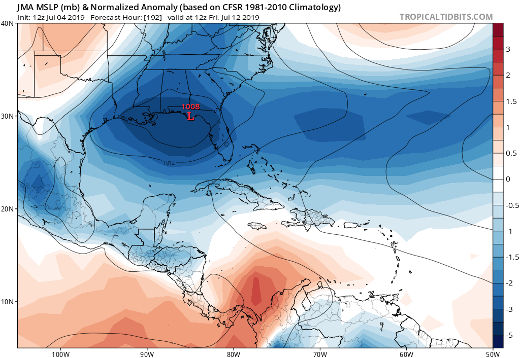
JMA with lowering of pressure as well:

Image
0 likes   

User avatar
Kingarabian
S2K Supporter
S2K Supporter
Posts: 15456
Joined: Sat Aug 08, 2009 3:06 am
Location: Honolulu, Hawaii

Re: 2019 Tropics: Global Model Runs Discussion (Out to day 16)

#164 Postby Kingarabian » Thu Jul 04, 2019 4:19 pm

StruThiO wrote:here is the MJO forecast. think models might flirt with an MDR system?
https://i.imgur.com/tyk65tx.png

They should be, but I'm assuming prsent large scale sinking motion and SAL will prohibit serious development. I think later in July we could see hints of an MDR system since SAL will likely be out the way.
4 likes   
RIP Kobe Bryant

USTropics
Category 5
Category 5
Posts: 2420
Joined: Sun Aug 12, 2007 3:45 am
Location: Florida State University

Re: 2019 Tropics: Global Model Runs Discussion (Out to day 16)

#165 Postby USTropics » Thu Jul 04, 2019 4:56 pm

northjaxpro wrote:


Well timed post after mine. This is the main reason and factor why I like the EURO's potential GOM scenario. SST's are extremely warm in the GOM currently. We will have to watch this potential very carefully next week!.


The past 3 operational runs of the GFS have backed off an EC solution, culminating int today's 12z GFS run that actually has an almost identical solution to the 12z ECMWF, with the vort maximum being established along the tail end in the GOM (albeit with no development):

Image

Looking at the ensembles, there will be quite a few variables that will ultimately determine where the vorticity consolidates. Various ensemble members show low pressure areas all along the frontal boundary up and down the EC (both the ECMWF and GFS ensembles).

12z GFS ensembles at 162 hours:
Image

12z ECMWF ensembles at 196 hours:
Image

Typically for this time of year, odds favor development along the tail end of the frontal boundary in the GOM. The shortwave trough will act to provide the necessary spin imo.
Last edited by USTropics on Thu Jul 04, 2019 4:58 pm, edited 1 time in total.
0 likes   

User avatar
Dylan
Professional-Met
Professional-Met
Posts: 337
Age: 29
Joined: Mon May 31, 2010 9:50 am
Location: New Orleans, LA

Re: 2019 Tropics: Global Model Runs Discussion (Out to day 16)

#166 Postby Dylan » Thu Jul 04, 2019 4:58 pm

4 likes   
Georges('98), Allison('01), Isidore('02), Lili('02), Frances('04) Ivan('04), Cindy('05), Katrina('05), Rita('05), Gustav('08), Isaac('12), Matthew('16), Harvey('17), Irma('17), Nate ('17), Ida ('21).

User avatar
NotSparta
Professional-Met
Professional-Met
Posts: 1658
Age: 22
Joined: Fri Aug 18, 2017 8:24 am
Location: Naples, FL
Contact:

Re: 2019 Tropics: Global Model Runs Discussion (Out to day 16)

#167 Postby NotSparta » Thu Jul 04, 2019 5:10 pm

Kingarabian wrote:
StruThiO wrote:here is the MJO forecast. think models might flirt with an MDR system?
[url]https://i.imgur.com/tyk65tx.png[url]

They should be, but I'm assuming prsent large scale sinking motion and SAL will prohibit serious development. I think later in July we could see hints of an MDR system since SAL will likely be out the way.


I believe there could be a sneaky AOI tucked into a large wave that has moister air. Those types aren't unusual in July MDR TCs
1 likes   
This post was probably an opinion of mine, and in no way is official. Please refer to http://www.hurricanes.gov for official tropical analysis and advisories.

My website, with lots of tropical wx graphics, including satellite and recon: http://cyclonicwx.com

USTropics
Category 5
Category 5
Posts: 2420
Joined: Sun Aug 12, 2007 3:45 am
Location: Florida State University

Re: 2019 Tropics: Global Model Runs Discussion (Out to day 16)

#168 Postby USTropics » Fri Jul 05, 2019 2:45 am

00z GFS and 00z ECMWF runs forecasting development along the GOM coastline.

00z GFS @ 210 hrs:
Image

00z ECMWF @ 192 hrs:
Image

It's still long range and plenty of time to watch. Genesis isn't guaranteed, but continuity and model agreement has increased. For now, watch the outflow boundary in northern Missouri. A shortwave trough should be ejected later today and begin to head SE around the periphery of the high pressure area.

Image
2 likes   

User avatar
GCANE
S2K Supporter
S2K Supporter
Posts: 10787
Joined: Mon Oct 22, 2007 8:03 am

Re: 2019 Tropics: Global Model Runs Discussion (Out to day 16)

#169 Postby GCANE » Fri Jul 05, 2019 4:06 am

Looks like GFS has an anticyclone sitting over the top of the surface low for an extended period of time.
However, it is bouncing all over the place land and water.
Needless to say if it gets out early over water and stays there, development could be quick.
Forecast showing relatively high instability in the NE GOM during this time.
0 likes   

User avatar
Hypercane_Kyle
Category 5
Category 5
Posts: 2901
Joined: Sat Mar 07, 2015 7:58 pm
Location: Cape Canaveral, FL

Re: 2019 Tropics: Global Model Runs Discussion (Out to day 16)

#170 Postby Hypercane_Kyle » Fri Jul 05, 2019 9:54 am

SSTs in the GOMEX have been well-above average his year.

Image
0 likes   
My posts are my own personal opinion, defer to the National Hurricane Center (NHC) and other NOAA products for decision making during hurricane season.

User avatar
drezee
S2K Supporter
S2K Supporter
Posts: 3644
Joined: Mon Jun 09, 2003 12:49 pm
Location: FL

Re: 2019 Tropics: Global Model Runs Discussion (Out to day 16)

#171 Postby drezee » Fri Jul 05, 2019 1:33 pm

12z Euro still onboard for N GoM Tropical Cyclone!!! 4 straight runs
0 likes   

User avatar
chaser1
S2K Supporter
S2K Supporter
Posts: 4731
Age: 63
Joined: Sat Oct 15, 2005 5:59 pm
Location: Longwood, Fl

Re: 2019 Tropics: Global Model Runs Discussion (Out to day 16)

#172 Postby chaser1 » Fri Jul 05, 2019 2:51 pm

drezee wrote:12z Euro still onboard for N GoM Tropical Cyclone!!! 4 straight runs


Far less impressive then prior 0Z run however. That and, GFS support is marginal at best. I'm still far from "sold" on actual TC evolution occuring in the GOM within the next 240 hrs.

I do think that any development here would fit within the scope of this years' general pattern. Just not sure that any near-term CONUS low will actually drop far enough south.
3 likes   
Personal Forecast Disclaimer:
The posts in this forum are NOT official forecast and should not be used as such. They are just the opinion of the poster and may or may not be backed by sound meteorological data. They are NOT endorsed by any professional institution or storm2k.org. For official information, please refer to the NHC and NWS products.


User avatar
Hypercane_Kyle
Category 5
Category 5
Posts: 2901
Joined: Sat Mar 07, 2015 7:58 pm
Location: Cape Canaveral, FL

Re: 2019 Tropics: Global Model Runs Discussion (Out to day 16)

#173 Postby Hypercane_Kyle » Fri Jul 05, 2019 4:16 pm

chaser1 wrote:
drezee wrote:12z Euro still onboard for N GoM Tropical Cyclone!!! 4 straight runs


Far less impressive then prior 0Z run however. That and, GFS support is marginal at best. I'm still far from "sold" on actual TC evolution occuring in the GOM within the next 240 hrs.

I do think that any development here would fit within the scope of this years' general pattern. Just not sure that any near-term CONUS low will actually drop far enough south.


Wouldn't pay much intensity to the ECMWF in terms of intensity this far out. Almost always lowballs storms beyond 120 hours. The fact it has consistently shown a storm this far out is worth noting.
1 likes   
My posts are my own personal opinion, defer to the National Hurricane Center (NHC) and other NOAA products for decision making during hurricane season.

User avatar
AtlanticWind
S2K Supporter
S2K Supporter
Posts: 1806
Age: 65
Joined: Sun Aug 08, 2004 9:57 pm
Location: Plantation,Fla

Re: 2019 Tropics: Global Model Runs Discussion (Out to day 16)

#174 Postby AtlanticWind » Fri Jul 05, 2019 5:08 pm

What is the GFS legacy model on tropical tidbits? Is this the older version of the gfs?
0 likes   

User avatar
TheStormExpert
Category 5
Category 5
Posts: 8487
Age: 30
Joined: Wed Feb 16, 2011 5:38 pm
Location: Palm Beach Gardens, FL

Re: 2019 Tropics: Global Model Runs Discussion (Out to day 16)

#175 Postby TheStormExpert » Fri Jul 05, 2019 5:11 pm

This setup seems very similar to when TS Edouard formed back in 2008.
0 likes   
The following post is NOT an official forecast and should not be used as such. It is just the opinion of the poster and may or may not be backed by sound meteorological data. It is NOT endorsed by storm2k.org.

User avatar
drezee
S2K Supporter
S2K Supporter
Posts: 3644
Joined: Mon Jun 09, 2003 12:49 pm
Location: FL

Re: 2019 Tropics: Global Model Runs Discussion (Out to day 16)

#176 Postby drezee » Fri Jul 05, 2019 5:23 pm

TheStormExpert wrote:This setup seems very similar to when TS Edouard formed back in 2008.

Yes, the weather channel has been talking that analog up. Danny 1997 is also a great analog
0 likes   

USTropics
Category 5
Category 5
Posts: 2420
Joined: Sun Aug 12, 2007 3:45 am
Location: Florida State University

Re: 2019 Tropics: Global Model Runs Discussion (Out to day 16)

#177 Postby USTropics » Fri Jul 05, 2019 5:32 pm

12z ECMWF ensembles increasing in probability of genesis:

Image
0 likes   

User avatar
drezee
S2K Supporter
S2K Supporter
Posts: 3644
Joined: Mon Jun 09, 2003 12:49 pm
Location: FL

Re: 2019 Tropics: Global Model Runs Discussion (Out to day 16)

#178 Postby drezee » Fri Jul 05, 2019 5:47 pm

That is one heck of a wave coming off Africa. It has the monsoon tail and a LLC per surface obs. If it was mid-August...the NHC wiuld be calling near 100% odds

Sierra Leone surface winds turned from W to S and SSE after passage
2 likes   

User avatar
artist
Category 5
Category 5
Posts: 9793
Joined: Mon Jun 06, 2005 3:26 pm
Location: West Palm

Re: 2019 Tropics: Global Model Runs Discussion (Out to day 16)

#179 Postby artist » Fri Jul 05, 2019 7:28 pm

This could get interesting. See what Sunday brings, by way of the models.
0 likes   

stormlover2013
Category 5
Category 5
Posts: 2312
Joined: Thu Aug 22, 2013 12:06 pm
Location: Lumberton, Texas

Re: 2019 Tropics: Global Model Runs Discussion (Out to day 16)

#180 Postby stormlover2013 » Fri Jul 05, 2019 8:05 pm

Just remember this is a different setup, will be fun to watch an see if something develops, I say Monday or Tuesday we will have a grasp on what’s going to happen. Models will keep wavering back and forth
0 likes   


Return to “Talkin' Tropics”

Who is online

Users browsing this forum: gib, Google [Bot], Stratton23 and 29 guests