2018 EPAC Season

This is the general tropical discussion area. Anyone can take their shot at predicting a storms path.

Moderator: S2k Moderators

Forum rules

The posts in this forum are NOT official forecasts and should not be used as such. They are just the opinion of the poster and may or may not be backed by sound meteorological data. They are NOT endorsed by any professional institution or STORM2K. For official information, please refer to products from the National Hurricane Center and National Weather Service.

Help Support Storm2K
Message
Author
User avatar
Kingarabian
S2K Supporter
S2K Supporter
Posts: 15451
Joined: Sat Aug 08, 2009 3:06 am
Location: Honolulu, Hawaii

Re: 2018 EPAC Season

#181 Postby Kingarabian » Wed May 30, 2018 2:24 pm

cycloneye wrote:At 12z model package,the consensus continued with the main model GFS and ECMWF. At this run,Euro is much more bullish.

[img]https://i.imgur.com/K6a6xHt.png[img]


Yes, much more bullish.
1 likes   
RIP Kobe Bryant

User avatar
Kingarabian
S2K Supporter
S2K Supporter
Posts: 15451
Joined: Sat Aug 08, 2009 3:06 am
Location: Honolulu, Hawaii

Re: 2018 EPAC Season

#182 Postby Kingarabian » Wed May 30, 2018 5:11 pm

Strong signal for TC development in the EPAC early next week on the 12Z EPS:

Image

PC - Ryan Maue -http://www.weathermodels.com
0 likes   
RIP Kobe Bryant

User avatar
cycloneye
Admin
Admin
Posts: 139327
Age: 67
Joined: Thu Oct 10, 2002 10:54 am
Location: San Juan, Puerto Rico

Re: 2018 EPAC Season

#183 Postby cycloneye » Wed May 30, 2018 7:33 pm

Looks like there are issues with the GFS plots with server but FV3 is running with a cat 2.

Image
0 likes   
Visit the Caribbean-Central America Weather Thread where you can find at first post web cams,radars
and observations from Caribbean basin members Click Here

aperson
S2K Supporter
S2K Supporter
Posts: 336
Age: 36
Joined: Thu Sep 22, 2005 10:56 pm

Re: 2018 EPAC Season

#184 Postby aperson » Wed May 30, 2018 7:41 pm

18z GFS is similar but less aggressive with lowest MSLP bottoming out around 979

Image
0 likes   

User avatar
cycloneye
Admin
Admin
Posts: 139327
Age: 67
Joined: Thu Oct 10, 2002 10:54 am
Location: San Juan, Puerto Rico

Re: 2018 EPAC Season

#185 Postby cycloneye » Wed May 30, 2018 8:37 pm

Maue did not have the quiet thing right as ONE-E formed.

@RyanMaue
Still waiting on the first named storm in the Eastern Pacific ... ECMWF 12z (parallel & op) indicate development in 8-10 days off the coast of Mexico.
Hurricane season started on May 15th in the EPAC but it has been very quiet.


 https://twitter.com/RyanMaue/status/1001998029975584768


0 likes   
Visit the Caribbean-Central America Weather Thread where you can find at first post web cams,radars
and observations from Caribbean basin members Click Here

User avatar
cycloneye
Admin
Admin
Posts: 139327
Age: 67
Joined: Thu Oct 10, 2002 10:54 am
Location: San Juan, Puerto Rico

Re: 2018 EPAC Season

#186 Postby cycloneye » Thu May 31, 2018 11:41 am

The timeframe by GFS at 12z to begin development has gone down to 144 hours. (Next Wednesday)

Image
0 likes   
Visit the Caribbean-Central America Weather Thread where you can find at first post web cams,radars
and observations from Caribbean basin members Click Here

User avatar
cycloneye
Admin
Admin
Posts: 139327
Age: 67
Joined: Thu Oct 10, 2002 10:54 am
Location: San Juan, Puerto Rico

Re: 2018 EPAC Season

#187 Postby cycloneye » Thu May 31, 2018 1:31 pm

12z ECMWF now is in the same 144 hours as GFS when it begins development.

Image
0 likes   
Visit the Caribbean-Central America Weather Thread where you can find at first post web cams,radars
and observations from Caribbean basin members Click Here

User avatar
Yellow Evan
Professional-Met
Professional-Met
Posts: 15956
Age: 25
Joined: Fri Jul 15, 2011 12:48 pm
Location: Henderson, Nevada/Honolulu, HI
Contact:

Re: 2018 EPAC Season

#188 Postby Yellow Evan » Thu May 31, 2018 2:01 pm

Image

Image

ECMWF and GFS remain in excellent agreement at a system in six days starting around 100W. Track will likely shift westward in upcoming days.
1 likes   

User avatar
cycloneye
Admin
Admin
Posts: 139327
Age: 67
Joined: Thu Oct 10, 2002 10:54 am
Location: San Juan, Puerto Rico

Re: 2018 EPAC Season

#189 Postby cycloneye » Thu May 31, 2018 6:23 pm

First mention not at TWO but at discussion:

Gulf of Tehuantepec: Moderate nocturnal drainage is forecast to
resume on Sat night as a surface low is forecast to develop
along the monsoon trough near 12N101W. The low should move west
of the area on Sun night
.
2 likes   
Visit the Caribbean-Central America Weather Thread where you can find at first post web cams,radars
and observations from Caribbean basin members Click Here

User avatar
Yellow Evan
Professional-Met
Professional-Met
Posts: 15956
Age: 25
Joined: Fri Jul 15, 2011 12:48 pm
Location: Henderson, Nevada/Honolulu, HI
Contact:

Re: 2018 EPAC Season

#190 Postby Yellow Evan » Fri Jun 01, 2018 12:25 am

Image

000
ABPZ20 KNHC 010517
TWOEP

Tropical Weather Outlook
NWS National Hurricane Center Miami FL
1100 PM PDT Thu May 31 2018

For the eastern North Pacific...east of 140 degrees west longitude:

An area of low pressure could form in a few days several hundred
miles south of the southern coast of Mexico. Conditions appear
favorable for some slow development of this system early next week
while it moves westward to west-northwestward at 5 to 10 mph.
* Formation chance through 48 hours...low...near 0 percent.
* Formation chance through 5 days...low...20 percent.
4 likes   

User avatar
Kingarabian
S2K Supporter
S2K Supporter
Posts: 15451
Joined: Sat Aug 08, 2009 3:06 am
Location: Honolulu, Hawaii

Re: 2018 EPAC Season

#191 Postby Kingarabian » Fri Jun 01, 2018 3:44 am

00z has back to showing a strong hurricane moving west.
0 likes   
RIP Kobe Bryant

User avatar
cycloneye
Admin
Admin
Posts: 139327
Age: 67
Joined: Thu Oct 10, 2002 10:54 am
Location: San Juan, Puerto Rico

Re: 2018 EPAC Season

#192 Postby cycloneye » Fri Jun 01, 2018 4:57 am

Kingarabian wrote:00z has back to showing a strong hurricane moving west.


Is a strong longtracker that Euro has.

Image
1 likes   
Visit the Caribbean-Central America Weather Thread where you can find at first post web cams,radars
and observations from Caribbean basin members Click Here

User avatar
cycloneye
Admin
Admin
Posts: 139327
Age: 67
Joined: Thu Oct 10, 2002 10:54 am
Location: San Juan, Puerto Rico

Re: 2018 EPAC Season

#193 Postby cycloneye » Fri Jun 01, 2018 8:00 am

Tropical Weather Outlook
NWS National Hurricane Center Miami FL
500 AM PDT Fri Jun 1 2018

For the eastern North Pacific...east of 140 degrees west longitude:

An area of low pressure could form by early next week several
hundred miles south of the southern coast of Mexico. Environmental
conditions appear conducive for gradual development of this system
while it moves westward to west-northwestward at 5 to 10 mph.
* Formation chance through 48 hours...low...near 0 percent.
* Formation chance through 5 days...low...20 percent.

$$
Forecaster Cangialosi
1 likes   
Visit the Caribbean-Central America Weather Thread where you can find at first post web cams,radars
and observations from Caribbean basin members Click Here

User avatar
gatorcane
S2K Supporter
S2K Supporter
Posts: 23499
Age: 46
Joined: Sun Mar 13, 2005 3:54 pm
Location: Boca Raton, FL

Re: 2018 EPAC Season

#194 Postby gatorcane » Fri Jun 01, 2018 2:02 pm

12Z ECMWF has the EPAC long-tracker down to 967MB by day 10 heading west with another one forming further east.

Image
0 likes   

User avatar
cycloneye
Admin
Admin
Posts: 139327
Age: 67
Joined: Thu Oct 10, 2002 10:54 am
Location: San Juan, Puerto Rico

Re: 2018 EPAC Season

#195 Postby cycloneye » Fri Jun 01, 2018 2:07 pm

Tropical Weather Outlook
NWS National Hurricane Center Miami FL
1100 AM PDT Fri Jun 1 2018

For the eastern North Pacific...east of 140 degrees west longitude:

A broad area of low pressure is expected to develop by early next
week a few hundred miles south of the southern coast of Mexico.
Gradual development of this system is possible thereafter while it
moves slowly west-northwestward.
* Formation chance through 48 hours...low...near 0 percent.
* Formation chance through 5 days...low...30 percent.

$$
Forecaster Cangialosi
1 likes   
Visit the Caribbean-Central America Weather Thread where you can find at first post web cams,radars
and observations from Caribbean basin members Click Here

User avatar
Kingarabian
S2K Supporter
S2K Supporter
Posts: 15451
Joined: Sat Aug 08, 2009 3:06 am
Location: Honolulu, Hawaii

Re: 2018 EPAC Season

#196 Postby Kingarabian » Fri Jun 01, 2018 2:23 pm

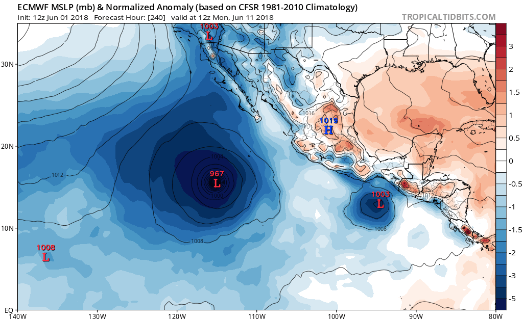
gatorcane wrote:12Z ECMWF has the EPAC long-tracker down to 967MB by day 10 heading west with another one forming further east.

[img]https://s22.postimg.cc/kv50c4v75/ecmwf_mslpa_Norm_epac_11.png[img]


Yep, same as the 12z GFS.
0 likes   
RIP Kobe Bryant

User avatar
Yellow Evan
Professional-Met
Professional-Met
Posts: 15956
Age: 25
Joined: Fri Jul 15, 2011 12:48 pm
Location: Henderson, Nevada/Honolulu, HI
Contact:

Re: 2018 EPAC Season

#197 Postby Yellow Evan » Fri Jun 01, 2018 2:30 pm

Image

12z FV3 suggests exciting times are ahead. Looking forward to some old school EPAC activity.... something I haven't felt since Kenneth last year
1 likes   

User avatar
cycloneye
Admin
Admin
Posts: 139327
Age: 67
Joined: Thu Oct 10, 2002 10:54 am
Location: San Juan, Puerto Rico

Re: 2018 EPAC Season

#198 Postby cycloneye » Fri Jun 01, 2018 2:32 pm

As always CMC does,it gives birth to a chain of cyclones. :)
0 likes   
Visit the Caribbean-Central America Weather Thread where you can find at first post web cams,radars
and observations from Caribbean basin members Click Here

User avatar
Yellow Evan
Professional-Met
Professional-Met
Posts: 15956
Age: 25
Joined: Fri Jul 15, 2011 12:48 pm
Location: Henderson, Nevada/Honolulu, HI
Contact:

Re: 2018 EPAC Season

#199 Postby Yellow Evan » Fri Jun 01, 2018 2:34 pm

cycloneye wrote:As always CMC does,it gives birth a chain of cyclones. :)


CMC shows triple the amount of cyclones anytime conditions are about to be favorable in the EPAC or WPAC. It's like five times worse in the EPAC than the ATL, and that's saying something.
3 likes   

Ntxw
Storm2k Moderator
Storm2k Moderator
Posts: 21523
Joined: Wed Oct 21, 2009 6:34 pm
Location: DFW, Texas

Re: 2018 EPAC Season

#200 Postby Ntxw » Fri Jun 01, 2018 3:39 pm

Pretty good agreement in general from most global guidance a Hurricane will be tracking across the EPAC soon

Image

Image
3 likes   
The above post and any post by Ntxw is NOT an official forecast and should not be used as such. It is just the opinion of the poster and may or may not be backed by sound meteorological data. It is NOT endorsed by any professional institution including Storm2k. For official information, please refer to NWS products.

  Help support Storm2K!
Help Support Storm2K


Return to “Talkin' Tropics”

Who is online

Users browsing this forum: No registered users and 35 guests