About MDR.
https://twitter.com/cyclonicwx/status/1133179457026633728
2019 Indicators: SST'S / Sal / MSLP / Steering / Shear / Instability (See updated graphics at first post)
Moderator: S2k Moderators
Forum rules

The posts in this forum are NOT official forecasts and should not be used as such. They are just the opinion of the poster and may or may not be backed by sound meteorological data. They are NOT endorsed by any professional institution or STORM2K. For official information, please refer to products from the National Hurricane Center and National Weather Service.
-
cycloneye

- Admin

- Posts: 139406
- Age: 67
- Joined: Thu Oct 10, 2002 10:54 am
- Location: San Juan, Puerto Rico
Re: 2019 Indicators: SST'S / Sal / MSLP / Steering / Shear / Instability (See updated graphics at first post)
0 likes
Visit the Caribbean-Central America Weather Thread where you can find at first post web cams,radars
and observations from Caribbean basin members Click Here
and observations from Caribbean basin members Click Here
-
StruThiO

- Category 3

- Posts: 821
- Age: 24
- Joined: Fri Sep 15, 2017 5:51 am
- Location: Currently Portland, OR. Raised in Jax, FL.
Re: 2019 Indicators: SST'S / Sal / MSLP / Steering / Shear / Instability (See updated graphics at first post)
Interesting.
https://twitter.com/crownweather/status/1133379672878833664
https://twitter.com/crownweather/status/1133379673671503872
https://twitter.com/AndyHazelton/status/1133381298633039874
https://twitter.com/crownweather/status/1133379672878833664
https://twitter.com/crownweather/status/1133379673671503872
https://twitter.com/AndyHazelton/status/1133381298633039874
1 likes
-
TheStormExpert

- Category 5

- Posts: 8487
- Age: 30
- Joined: Wed Feb 16, 2011 5:38 pm
- Location: Palm Beach Gardens, FL
Re: 2019 Indicators: SST'S / Sal / MSLP / Steering / Shear / Instability (See updated graphics at first post)
Doesn’t mean for certain that a high impact Gulf year is guaranteed but a high impact year nonetheless is becoming seemingly more likely in my opinion, especially if the ENSO goes back neutral for peak season.
2 likes
The following post is NOT an official forecast and should not be used as such. It is just the opinion of the poster and may or may not be backed by sound meteorological data. It is NOT endorsed by storm2k.org.
-
gatorcane

- S2K Supporter

- Posts: 23499
- Age: 46
- Joined: Sun Mar 13, 2005 3:54 pm
- Location: Boca Raton, FL
Re: 2019 Indicators: SST'S / Sal / MSLP / Steering / Shear / Instability (See updated graphics at first post)
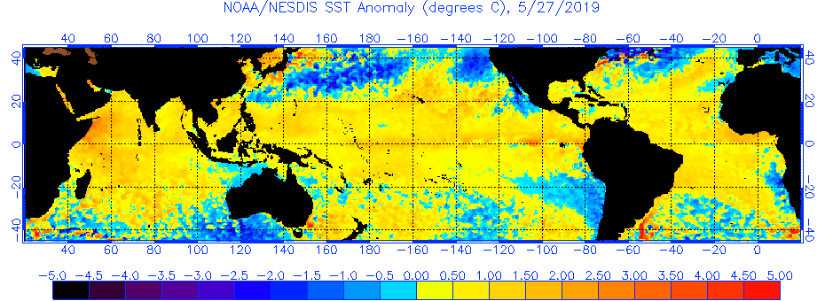
Latest SST anomalies have the look of a potentially active season with cooler than normal northern/subtropical Atlantic and warmer than normal tropical Atlantic:
4 likes
-
cycloneye
- Admin
- Posts: 139406
- Age: 67
- Joined: Thu Oct 10, 2002 10:54 am
- Location: San Juan, Puerto Rico
Re: 2019 Indicators: SST'S / Sal / MSLP / Steering / Shear / Instability (See updated graphics at first post)
Mark Sudduth new Hurricane Outlook and Discussion.
https://twitter.com/hurricanetrack/status/1133468219673595907
https://twitter.com/hurricanetrack/status/1133468219673595907
5 likes
Visit the Caribbean-Central America Weather Thread where you can find at first post web cams,radars
and observations from Caribbean basin members Click Here
and observations from Caribbean basin members Click Here
-
SFLcane

- S2K Supporter
- Posts: 9618
- Age: 46
- Joined: Sat Jun 05, 2010 1:44 pm
- Location: Lake Worth Florida
Re: 2019 Indicators: SST'S / Sal / MSLP / Steering / Shear / Instability (See updated graphics at first post)
Great video! Mark put everything in perspective
0 likes
-
SFLcane
- S2K Supporter
- Posts: 9618
- Age: 46
- Joined: Sat Jun 05, 2010 1:44 pm
- Location: Lake Worth Florida
Re: 2019 Indicators: SST'S / Sal / MSLP / Steering / Shear / Instability (See updated graphics at first post)
In all honesty I am not sure what to make of all this it’s a far cry from the extremely hostile slow season wxman57 posted about a few weeks ago back here.
1 likes
-
AutoPenalti
- Category 5
- Posts: 3950
- Age: 27
- Joined: Mon Aug 17, 2015 4:16 pm
- Location: Ft. Lauderdale, Florida
Re: 2019 Indicators: SST'S / Sal / MSLP / Steering / Shear / Instability (See updated graphics at first post)
Part of me thought this would be an inactive season with ACE > 80, but now with the latest ENSO runs along with increased SST's in the MDR with an active WAM and lower than average shear across the basin... I'm not so sure anymore.
2 likes
The posts in this forum are NOT official forecasts and should not be used as such. They are just the opinion of the poster and may or may not be backed by sound meteorological data. They are NOT endorsed by any professional institution or STORM2K. For official information, please refer to products from the NHC and NWS.
Model Runs Cheat Sheet:
GFS (5:30 AM/PM, 11:30 AM/PM)
HWRF, GFDL, UKMET, NAVGEM (6:30-8:00 AM/PM, 12:30-2:00 AM/PM)
ECMWF (1:45 AM/PM)
TCVN is a weighted averaged

Re: 2019 Indicators: SST'S / Sal / MSLP / Steering / Shear / Instability (See updated graphics at first post)
AutoPenalti wrote:Part of me thought this would be an inactive season with ACE > 80, but now with the latest ENSO runs along with increased SST's in the MDR with an active WAM and lower than average shear across the basin... I'm not so sure anymore.
My biggest conflict is whether I truly buy into the notion that upper level shear across the basin, is truly going to transition as significantly as the CFSv2 has been suggesting over the last couple of weeks. I realize that it's only late May but the CFSv2 200mb - 850mb forecast monthlies are really "doing a 180" by reversing present hostile Westerly UL winds from 25N southward and largely across the Atlantic basin, to a sudden "neutral flow" in July. This in spite of it's July forecast of maintaining strong Westerly UL wind anomaly over the E. Pacific from 15N and southward from there. Finally, it's August forecast eliminates all indication of Atlantic basin anomalous upper level shear conditions with the exception of a band of anomalous UL shear across lower latitudes of the MDR between Africa and the Lessor Antilles. In this case the suggested low latitude shear conditions seem to be in relation to strong Easterly regime, and not reflective at all of any ENSO influence. To me, the CFSv2 long range forecast would seem to reasonably fit within climatology if we were presently experiencing an ENSO neutral pattern right now. Considering that the present ENSO state that has been fairly entrenched for the last 6 months or so was never moderate or strong to begin with, it's slow waning over the East PAC makes me think that a transition to more ENSO neutral conditions across the Atlantic would be slower to occur as well. If this were to be true, then residual ENSO conditions would continue to inhibit development within the S. Gulf, Caribbean, Atlantic MDR and considerably impact those strong Easterly waves that may result from an anticipated vigorous W. Africa monsoon. Perhaps the net result over the far Eastern Atlantic MDR come July or August, will be a couple of fast "spin-ups" before either unraveling as they trek eastward and quickly encounter less favorable conditions or possibly turn sharply pole-ward in response to any far E. Atlantic trough.
None of this takes away from tropical development that a lot of us anticipate will probably occur within some "Goldilocks" zone potentially ranging from the Gulf, across Florida eastward to north of the Greater Antilles, as well as points north from there. Right now though, I'm still questioning two things

1) Will W. Hemisphere pattern changes that result in far more favorable UL conditions within the Caribbean or tropical Atlantic actually transition as quickly & significantly by late July?
2) If a significantly favorable UL pattern were to broadly establish itself this summer from the Gulf, S.E. CONUS, to just north of the Greater Antilles, whether this in combination with other favorable dynamics suggest an even greater enhanced threat of stronger hurricanes to develop within this region then I was originally anticipating for the upcoming season?
I'm beginning to hedge toward the increased concern of the latter occurring. I'm still not quite buying into the former though. I'm still betting (and hoping) that the Lesser Antilles, Puerto Rico, D.R., Cuba, and Jamaica will for the most part get a pass this season.
3 likes
Personal Forecast Disclaimer:
The posts in this forum are NOT official forecast and should not be used as such. They are just the opinion of the poster and may or may not be backed by sound meteorological data. They are NOT endorsed by any professional institution or storm2k.org. For official information, please refer to the NHC and NWS products.
The posts in this forum are NOT official forecast and should not be used as such. They are just the opinion of the poster and may or may not be backed by sound meteorological data. They are NOT endorsed by any professional institution or storm2k.org. For official information, please refer to the NHC and NWS products.
-
NotSparta

- Professional-Met

- Posts: 1656
- Age: 22
- Joined: Fri Aug 18, 2017 8:24 am
- Location: Naples, FL
- Contact:
Re: 2019 Indicators: SST'S / Sal / MSLP / Steering / Shear / Instability (See updated graphics at first post)
chaser1 wrote:AutoPenalti wrote:Part of me thought this would be an inactive season with ACE > 80, but now with the latest ENSO runs along with increased SST's in the MDR with an active WAM and lower than average shear across the basin... I'm not so sure anymore.
My biggest conflict is whether I truly buy into the notion that upper level shear across the basin, is truly going to transition as significantly as the CFSv2 has been suggesting over the last couple of weeks. I realize that it's only late May but the CFSv2 200mb - 850mb forecast monthlies are really "doing a 180" by reversing present hostile Westerly UL winds from 25N southward and largely across the Atlantic basin, to a sudden "neutral flow" in July. This in spite of it's July forecast of maintaining strong Westerly UL wind anomaly over the E. Pacific from 15N and southward from there. Finally, it's August forecast eliminates all indication of Atlantic basin anomalous upper level shear conditions with the exception of a band of anomalous UL shear across lower latitudes of the MDR between Africa and the Lessor Antilles. In this case the suggested low latitude shear conditions seem to be in relation to strong Easterly regime, and not reflective at all of any ENSO influence. To me, the CFSv2 long range forecast would seem to reasonably fit within climatology if we were presently experiencing an ENSO neutral pattern right now. Considering that the present ENSO state that has been fairly entrenched for the last 6 months or so was never moderate or strong to begin with, it's slow waning over the East PAC makes me think that a transition to more ENSO neutral conditions across the Atlantic would be slower to occur as well. If this were to be true, then residual ENSO conditions would continue to inhibit development within the S. Gulf, Caribbean, Atlantic MDR and considerably impact those strong Easterly waves that may result from an anticipated vigorous W. Africa monsoon. Perhaps the net result over the far Eastern Atlantic MDR come July or August, will be a couple of fast "spin-ups" before either unraveling as they trek eastward and quickly encounter less favorable conditions or possibly turn sharply pole-ward in response to any far E. Atlantic trough.
None of this takes away from tropical development that a lot of us anticipate will probably occur within some "Goldilocks" zone potentially ranging from the Gulf, across Florida eastward to north of the Greater Antilles, as well as points north from there. Right now though, I'm still questioning two things
1) Will W. Hemisphere pattern changes that result in far more favorable UL conditions within the Caribbean or tropical Atlantic actually transition as quickly & significantly by late July?
2) If a significantly favorable UL pattern were to broadly establish itself this summer from the Gulf, S.E. CONUS, to just north of the Greater Antilles, whether this in combination with other favorable dynamics suggest an even greater enhanced threat of stronger hurricanes to develop within this region then I was originally anticipating for the upcoming season?
I'm beginning to hedge toward the increased concern of the latter occurring. I'm still not quite buying into the former though. I'm still betting (and hoping) that the Lesser Antilles, Puerto Rico, D.R., Cuba, and Jamaica will for the most part get a pass this season.
Seems extreme to me as well but I guess that the very strong WAM, like last yr, would decrease shear, along w/ little reflection of El Niño at that point.
0 likes
This post was probably an opinion of mine, and in no way is official. Please refer to http://www.hurricanes.gov for official tropical analysis and advisories.
My website, with lots of tropical wx graphics, including satellite and recon: http://cyclonicwx.com
My website, with lots of tropical wx graphics, including satellite and recon: http://cyclonicwx.com
-
SFLcane
- S2K Supporter
- Posts: 9618
- Age: 46
- Joined: Sat Jun 05, 2010 1:44 pm
- Location: Lake Worth Florida
Re: 2019 Indicators: SST'S / Sal / MSLP / Steering / Shear / Instability (See updated graphics at first post)
It's ok just a matter of time before wxman57 returns and brings down the hammer with a ridiculously low ace season.
5 likes

Re: 2019 Indicators: SST'S / Sal / MSLP / Steering / Shear / Instability (See updated graphics at first post)
SFLcane wrote:It's ok just a matter of time before wxman57 returns and brings down the hammer with a ridiculously low ace season.
Is this jokey/sarcasm or am I missing something?
1 likes
Personal Forecast Disclaimer:
The posts in this forum are NOT official forecast and should not be used as such. They are just the opinion of the poster and may or may not be backed by sound meteorological data. They are NOT endorsed by any professional institution or storm2k.org. For official information, please refer to the NHC and NWS products.
The posts in this forum are NOT official forecast and should not be used as such. They are just the opinion of the poster and may or may not be backed by sound meteorological data. They are NOT endorsed by any professional institution or storm2k.org. For official information, please refer to the NHC and NWS products.
-
CyclonicFury

- Category 5
- Posts: 1976
- Age: 25
- Joined: Sun Jul 02, 2017 12:32 pm
- Location: NC
- Contact:
Re: 2019 Indicators: SST'S / Sal / MSLP / Steering / Shear / Instability (See updated graphics at first post)
SFLcane wrote:It's ok just a matter of time before wxman57 returns and brings down the hammer with a ridiculously low ace season.
Haha. If Wxman57 controlled the Atlantic, the first storm would form in mid-August, all storms would form in the deep tropics, and the last storm would dissipate in early October.
5 likes
NCSU B.S. in Meteorology Class of 2021. Tropical weather blogger at http://www.cyclonicfury.com. My forecasts and thoughts are NOT official, for official forecasts please consult the National Hurricane Center.
-
TheStormExpert
- Category 5
- Posts: 8487
- Age: 30
- Joined: Wed Feb 16, 2011 5:38 pm
- Location: Palm Beach Gardens, FL
Re: 2019 Indicators: SST'S / Sal / MSLP / Steering / Shear / Instability (See updated graphics at first post)
CyclonicFury wrote:SFLcane wrote:It's ok just a matter of time before wxman57 returns and brings down the hammer with a ridiculously low ace season.
Haha. If Wxman57 controlled the Atlantic, the first storm would form in mid-August, all storms would form in the deep tropics, and the last storm would dissipate in early October.
Sounds like a quality over quantity season to me!
2 likes
The following post is NOT an official forecast and should not be used as such. It is just the opinion of the poster and may or may not be backed by sound meteorological data. It is NOT endorsed by storm2k.org.
-
Hurricaneman

- Category 5
- Posts: 7284
- Age: 43
- Joined: Tue Aug 31, 2004 3:24 pm
- Location: central florida
Re: 2019 Indicators: SST'S / Sal / MSLP / Steering / Shear / Instability (See updated graphics at first post)
The more I look at things 2004 may be one of the top analogs as far as SSTA’s and based on that I wouldn’t expect much until July but by August I expect the floodgates of tropical systems to open up
0 likes
-
gatorcane
- S2K Supporter
- Posts: 23499
- Age: 46
- Joined: Sun Mar 13, 2005 3:54 pm
- Location: Boca Raton, FL
Re: 2019 Indicators: SST'S / Sal / MSLP / Steering / Shear / Instability (See updated graphics at first post)
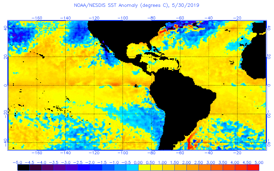
SST configuration continues to show above normal tropics and cooler than normal subtropics. Certainly has the look it could be an active MDR season. If this continues I think we are going to see expert forecasts up numbers to an above average season:
2 likes
-
storm_in_a_teacup

- Category 1

- Posts: 357
- Joined: Wed Aug 16, 2017 5:01 pm
- Location: Huntsville, Alabama (originally from Houston)
- Contact:
Re: 2019 Indicators: SST'S / Sal / MSLP / Steering / Shear / Instability (See updated graphics at first post)
So like I know for the western Gulf the really bad stuff usually comes at the end of August/beginning of September. I was planning to go back to Houston during July-early August since usually that's not too bad, but I guess what you guys seem to imply is those times will be bad for the western Gulf as well?
0 likes
I know I can't straddle the atmosphere...just a tiny storm in your teacup, girl.
-
Kingarabian

- S2K Supporter
- Posts: 15451
- Joined: Sat Aug 08, 2009 3:06 am
- Location: Honolulu, Hawaii
Re: 2019 Indicators: SST'S / Sal / MSLP / Steering / Shear / Instability (See updated graphics at first post)
gatorcane wrote:SST configuration continues to show above normal tropics and cooler than normal subtropics. Certainly has the look it could be an active MDR season. If this continues I think we are going to see expert forecasts up numbers to an above average season:
[url]https://i.postimg.cc/vBrWmrWV/anomw-5-30-2019.gif[url]
I think expert forecasters like Joe Bastardi use these type of CDAS/satellite temps like the one on tropical tidbits:

These still show a cooler MDR, although it has warmed up in recent weeks.
2 likes
RIP Kobe Bryant
Who is online
Users browsing this forum: cainjamin, cheezyWXguy, Google [Bot], Google Adsense [Bot], Hybridstorm_November2001, Killjoy12, NotSparta, SFLcane and 44 guests