
That upper level low just north of Cuba is starting to look less cold core.
Specifically the convection has been creeping in toward the center this evening and there is some anticyclonic shear in the upper levels.
Possible weak development east of FL this week? (Is 92L)
Moderator: S2k Moderators
Forum rules

The posts in this forum are NOT official forecasts and should not be used as such. They are just the opinion of the poster and may or may not be backed by sound meteorological data. They are NOT endorsed by any professional institution or STORM2K. For official information, please refer to products from the National Hurricane Center and National Weather Service.
-
tropicwatch

- Category 5

- Posts: 3205
- Age: 60
- Joined: Sat Jun 02, 2007 10:01 am
- Location: Panama City Florida
- Contact:
Re: Possible weak development east of FL this week?
Nope its still there and maybe tightening.

0 likes
Tropicwatch
Agnes 72', Eloise 75, Elena 85', Kate 85', Charley 86', Florence 88', Beryl 94', Dean 95', Erin 95', Opal 95', Earl 98', Georges 98', Ivan 2004', Arlene 2005', Dennis 2005', Ida 2009' Debby 2012' Irma 2017' Michael 2018'
Agnes 72', Eloise 75, Elena 85', Kate 85', Charley 86', Florence 88', Beryl 94', Dean 95', Erin 95', Opal 95', Earl 98', Georges 98', Ivan 2004', Arlene 2005', Dennis 2005', Ida 2009' Debby 2012' Irma 2017' Michael 2018'
-
floridasun78
- Category 5
- Posts: 3755
- Joined: Sun May 17, 2009 10:16 pm
- Location: miami fl
Re: Possible weak development east of FL this week?
panamatropicwatch wrote:Nope its still there and maybe tightening.
what tightening??? explain
0 likes
-
tropicwatch
- Category 5
- Posts: 3205
- Age: 60
- Joined: Sat Jun 02, 2007 10:01 am
- Location: Panama City Florida
- Contact:
0 likes
Tropicwatch
Agnes 72', Eloise 75, Elena 85', Kate 85', Charley 86', Florence 88', Beryl 94', Dean 95', Erin 95', Opal 95', Earl 98', Georges 98', Ivan 2004', Arlene 2005', Dennis 2005', Ida 2009' Debby 2012' Irma 2017' Michael 2018'
Agnes 72', Eloise 75, Elena 85', Kate 85', Charley 86', Florence 88', Beryl 94', Dean 95', Erin 95', Opal 95', Earl 98', Georges 98', Ivan 2004', Arlene 2005', Dennis 2005', Ida 2009' Debby 2012' Irma 2017' Michael 2018'
-
floridasun78
- Category 5
- Posts: 3755
- Joined: Sun May 17, 2009 10:16 pm
- Location: miami fl

Re: Possible weak development east of FL this week?
Looks to me like the transformation is slowly taking shape, T-storms firing near the cold core will start to warm the upper level and Cimss is showing a slight increase in the 850 vorticity. Something to check back on in the next few days
0 likes
The following post is NOT an official forecast and should not be used as such. It is just the opinion of the poster and may or may not be backed by sound meteorological data. It is NOT endorsed by any professional institution including storm2k.org For Official Information please refer to the NHC and NWS products.

Re: Possible weak development east of FL this week?
You guys are looking the ULL north of Cuba too much, the area to watch is just east of the ULL, north of Hispaniola where the H85 & H70 vorticity are, it is going to rotate around to the north of the ULL as the ULL shifts a little southward as it possible weakens and eventually repositions itself back further east with yet another ULL coming from the Atlantic, as this happens the H85 vorticity that has formed thanks to UL divergence might develop a surface reflection in a few days near the northern Bahamas.
0 likes
Re: Possible weak development east of FL this week?
0z GFS shows a weak low developing near the northern Bahamas then track westward towards southern FL and into the eastern GOM but opening back up as it does so.
0 likes
-
MGC

- S2K Supporter

- Posts: 5795
- Joined: Sun Mar 23, 2003 9:05 pm
- Location: Pass Christian MS, or what is left.
Re: Possible weak development east of FL this week?
Can't remember the last time a cold core bore itself to the surface and became a TC. Its a fairly rare occurance, so I'd go with the surface reflection senario as a possiblity. We just need to sit back and see what happens.....MGC
0 likes

Re: Possible weak development east of FL this week?
00z Euro shows fairly strong 850 mb vorticity moving from the Bahamas into Vero Beach and across south-central FL into the GOM in the 72-96 hour period.
http://mp1.met.psu.edu/~fxg1/ECMWFTROPATL0.5_0z/ecmwfloop.html
http://mp1.met.psu.edu/~fxg1/ECMWFTROPATL0.5_0z/ecmwfloop.html
0 likes
Re: Possible weak development east of FL this week?
NWS Miami AFD this morning:
MODELS ARE HINTING THAT AN INVERTED SURFACE TROUGH OR WEAK AREA OF
LOW PRESSURE MAY DEVELOP ACROSS THE NORTHWEST BAHAMAS TONIGHT AND
WEDNESDAY...AND THEN SLOWLY MOVE WEST AND ACROSS SOUTH FLORIDA BY
THE END OF THE WEEK AND INTO THE WEEKEND. THE ECMWF MOVES THIS FEATURE
INTO THE REGION THURSDAY AFTERNOON WHILE THE GFS HOLDS OFF UNTIL FRIDAY.
0 likes
Re: Possible weak development east of FL this week?
ULL sinking south into Cuba this am. Look for the low pressure center to develop north of the Turks and Caicos where convection is firing now.
http://www.ssd.noaa.gov/goes/east/watl/loop-wv.html
http://www.ssd.noaa.gov/goes/east/watl/loop-wv.html
0 likes
-
northjaxpro

- S2K Supporter
- Posts: 8900
- Joined: Mon Sep 27, 2010 11:21 am
- Location: Jacksonville, FL
You beat me to this ronjon. I also noticed the ULL drifting to the south as well. EURO showing Low Pressure to develop and drift across South Central Florida by late this week.
Looking at satellite imagery early this morning, the mid level vorticity approaching the SE Bahamas looks fairly impressive. This feature is looking better with time. I would be inclined to think we may have our next invest area real soon if the current trends continue with this feature.
Last edited by northjaxpro on Tue Sep 09, 2014 6:19 am, edited 1 time in total.
0 likes
NEVER, EVER SAY NEVER in the tropics and weather in general, and most importantly, with life itself!!
________________________________________________________________________________________
Fay 2008 Beryl 2012 Debby 2012 Colin 2016 Hermine 2016 Julia 2016 Matthew 2016 Irma 2017 Dorian 2019
________________________________________________________________________________________
Fay 2008 Beryl 2012 Debby 2012 Colin 2016 Hermine 2016 Julia 2016 Matthew 2016 Irma 2017 Dorian 2019
Re: Possible weak development east of FL this week?
If the remnants of the ULL dive south that would tend to kick the surface feature west.
Look at the first few visible frames the high cirrus clouds should be displaying an anticyclonic motion.
If that is occurring over the ULL then it is likely filling in.
Timing will be critical with Florida there but climo tells us these core conversions are usualy slow can take days.
NHC must be watching lets see what they say.
0 likes
Re: Possible weak development east of FL this week?
Lets see if the NHC mentions this feature this morning.
RAMMB has a floater over it.
http://rammb.cira.colostate.edu/ramsdis/online/loop.asp?data_folder=tropical/tropical_ge_4km_visir2_floater_1&width=640&height=480&number_of_images_to_display=12
RAMMB has a floater over it.
http://rammb.cira.colostate.edu/ramsdis/online/loop.asp?data_folder=tropical/tropical_ge_4km_visir2_floater_1&width=640&height=480&number_of_images_to_display=12
0 likes
-
TheStormExpert

- Category 5
- Posts: 8487
- Age: 30
- Joined: Wed Feb 16, 2011 5:38 pm
- Location: Palm Beach Gardens, FL
0 likes
The following post is NOT an official forecast and should not be used as such. It is just the opinion of the poster and may or may not be backed by sound meteorological data. It is NOT endorsed by storm2k.org.
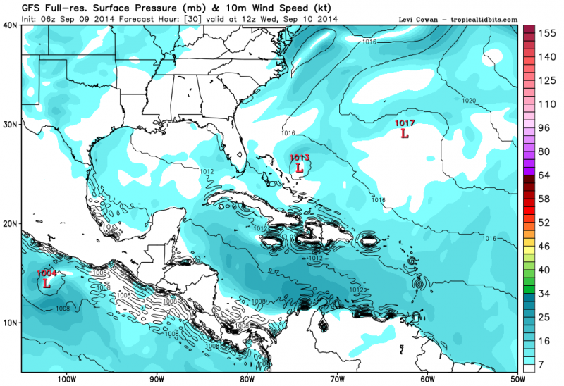
06z GFS has a weak low pressure developing by late tonight into tomorrow morning, has it then moving slowly westward towards S FL during late week into the eastern GOM by the weekend. The reason I see that it does not develops much is because of strong northerly UL shear from southern UL US ridge.
0 likes
-
jlauderdal
- S2K Supporter
- Posts: 6783
- Joined: Wed May 19, 2004 5:46 am
- Location: NE Fort Lauderdale
- Contact:
Re:
NDG wrote:06z GFS has a weak low pressure developing by late tonight into tomorrow morning, has it then moving slowly westward towards S FL during late week into the eastern GOM by the weekend. The reason I see that it does not develops much is because of strong northerly UL shear from southern UL US ridge.
bastardi kind of likes it, lets see what happens..been dry on the east coast after a very wet july
BigJoeBastardi
Been tracking this for clients.. Bahamas/FLA this system coming through the Bahamas could be problem http://t.co/hEnoUKlxbI
0 likes
Re: Possible weak development east of FL this week?
Can anyone tell how strong the Euro has it before crossing the State?
0 likes
Re: Possible weak development east of FL this week?
caneman wrote:Can anyone tell how strong the Euro has it before crossing the State?
Very weak like the GFS shows, maybe the h85 vorticity a tad stronger than the GFS.
0 likes
Who is online
Users browsing this forum: Google Adsense [Bot] and 65 guests