Possible development in Western Caribbean - (Is INVEST 93L)

This is the general tropical discussion area. Anyone can take their shot at predicting a storms path.

Moderator: S2k Moderators

Forum rules

The posts in this forum are NOT official forecasts and should not be used as such. They are just the opinion of the poster and may or may not be backed by sound meteorological data. They are NOT endorsed by any professional institution or STORM2K. For official information, please refer to products from the National Hurricane Center and National Weather Service.

Help Support Storm2K
Message
Author
Alyono
Professional-Met
Professional-Met
Posts: 6961
Joined: Fri Apr 26, 2013 3:52 pm
Location: Texas Coast

Re: Possible development in Western Caribbean

#21 Postby Alyono » Tue Jun 13, 2017 3:22 pm

TheStormExpert wrote:
Alyono wrote:
Kingarabian wrote:
Probably due to sheer size and time.


it has a full 2 days. Plenty of time

Alyono are you saying this could become a hurricane?


it cannot be ruled out
1 likes   

User avatar
Kingarabian
S2K Supporter
S2K Supporter
Posts: 15454
Joined: Sat Aug 08, 2009 3:06 am
Location: Honolulu, Hawaii

Re: Possible development in Western Caribbean

#22 Postby Kingarabian » Tue Jun 13, 2017 3:23 pm

Alyono wrote:
TheStormExpert wrote:
Alyono wrote:
it has a full 2 days. Plenty of time

Alyono are you saying this could become a hurricane?


it cannot be ruled out


Yeah, EPS just finished running and some members do have this as a Cat. 1 hurricane making landfall over Mexico.
1 likes   
RIP Kobe Bryant

Alyono
Professional-Met
Professional-Met
Posts: 6961
Joined: Fri Apr 26, 2013 3:52 pm
Location: Texas Coast

Re: Possible development in Western Caribbean

#23 Postby Alyono » Tue Jun 13, 2017 3:38 pm

80-90 percent chance of development according to the EC enemble
3 likes   

Stormcenter
S2K Supporter
S2K Supporter
Posts: 6617
Joined: Wed Sep 03, 2003 11:27 am
Location: Houston, TX

Re: Possible development in Western Caribbean

#24 Postby Stormcenter » Tue Jun 13, 2017 3:48 pm

Right now how fast this develops will be the key to whether or not whatever develops affects the U.S. IMO
1 likes   

User avatar
South Texas Storms
Professional-Met
Professional-Met
Posts: 4028
Joined: Thu Jun 24, 2010 12:28 am
Location: Houston, TX

Re: Possible development in Western Caribbean

#25 Postby South Texas Storms » Tue Jun 13, 2017 4:01 pm

Kingarabian wrote:
Alyono wrote:
TheStormExpert wrote:Alyono are you saying this could become a hurricane?


it cannot be ruled out


Yeah, EPS just finished running and some members do have this as a Cat. 1 hurricane making landfall over Mexico.


Yeah and several members still show it moving into TX. Can't rule out that scenario either.
4 likes   

User avatar
tarheelprogrammer
S2K Supporter
S2K Supporter
Posts: 1793
Joined: Mon Mar 28, 2016 9:25 pm
Location: Raleigh, NC area (Garner, NC)

Re: Possible development in Western Caribbean

#26 Postby tarheelprogrammer » Tue Jun 13, 2017 4:22 pm

1 likes   
My posts are not official forecasts. They are just my opinion and may or may not be backed by sound meteorological data. They are NOT endorsed by any professional institution or storm2k.org. For official information, please refer to the NHC and NWS products.

User avatar
Cpv17
Category 5
Category 5
Posts: 4408
Joined: Wed Dec 07, 2016 2:24 pm
Location: Wharton/El Campo, TX

Re: Possible development in Western Caribbean

#27 Postby Cpv17 » Tue Jun 13, 2017 4:34 pm

I'm no expert, but I'm pretty sure the stronger it is, the better chance it has moving more poleward depending on where exactly the ridge is at. A weaker storm will probably stay in the far southern BOC and crash into Mexico. The stronger the storm is, the more likely it is to feel the effects of the upper air pattern?
2 likes   

User avatar
PTrackerLA
Category 5
Category 5
Posts: 5248
Age: 40
Joined: Thu Oct 10, 2002 8:40 pm
Location: Lafayette, LA

Re: Possible development in Western Caribbean

#28 Postby PTrackerLA » Tue Jun 13, 2017 4:46 pm

Can't rule out Texas impacts but it looks like the ridging will be too strong to allow this to come to the northern Gulf coast like runs were showing a few days ago.
0 likes   

User avatar
KatDaddy
Category 5
Category 5
Posts: 2815
Joined: Mon Oct 21, 2002 6:23 pm
Location: League City, Texas

Re: Possible development in Western Caribbean

#29 Postby KatDaddy » Tue Jun 13, 2017 5:41 pm

The Houston-Galveston, Corpus Christi, and Brownsville NWS summarize this area in their afternoon AFDs.

Houston-Galveston NWS

An area of disturbed weather approaching the Yucatan will emerge
into the southern Gulf early next week. As this wave moves west
into Mexico, it might bring a surge of deeper moisture into Texas
with a chance of showers returning next Monday or Tuesday.

Corpus Christi NWS:

NHC is outlooking an area of disturbed weather that has a low chance
of developing into a tropical cyclone over the next five days. That
area obviously bears watching but as of now is no threat to Texas.

Brownsville NWS:

Under scrutiny will be a tropical wave moving west from the Western
Caribbean Sea on Sunday to over the Yucatan Peninsula and then into
the Southwest Gulf on Monday. This development is seen quite well in
the ECMWF model, for example. A weak, broad surface low will then
develop over the Southwest Gulf on Tuesday, possibly causing winds
to back to east or northeast over the Northwest Gulf if any kind of
circulation is able to develop. The surface low should continue
moving west to the Mexican Coast and then inland, resulting in
enhanced rain chances for the County Warning Area, on the northern
periphery of the low`s influence, heading into the middle of next
week.
0 likes   
The following post is NOT an official forecast and should not be used as such. It is just the opinion of the poster and may or may not be backed by sound meteorological data. It is NOT endorsed by any professional institution including storm2k.org For Official Information please refer to the NHC and NWS products.

User avatar
tailgater
S2K Supporter
S2K Supporter
Posts: 3339
Joined: Sun Jul 11, 2004 9:13 pm
Location: St. Amant La.

Re: Possible development in Western Caribbean

#30 Postby tailgater » Tue Jun 13, 2017 5:56 pm

Latest GFS run has it slowly developing and heads north in western GOM but pulls up short of Hou/Gal area then retreats SWard Looks like a bad run IMHO.

Image
1 likes   
The following post is NOT an official forecast and should not be used as such. It is just the opinion of the poster and may or may not be backed by sound meteorological data. It is NOT endorsed by any professional institution including storm2k.org For Official Information please refer to the NHC and NWS products.

User avatar
Cpv17
Category 5
Category 5
Posts: 4408
Joined: Wed Dec 07, 2016 2:24 pm
Location: Wharton/El Campo, TX

Re: Possible development in Western Caribbean

#31 Postby Cpv17 » Tue Jun 13, 2017 6:03 pm

I don't think we'll know where this storm will go anytime soon. Maybe if it develops into something we'll have a better idea. Possibly this weekend. I still believe anywhere from Louisiana to Mexico should keep an eye on it.
0 likes   

User avatar
cycloneye
Admin
Admin
Posts: 139493
Age: 67
Joined: Thu Oct 10, 2002 10:54 am
Location: San Juan, Puerto Rico

Re: Possible development in Western Caribbean

#32 Postby cycloneye » Tue Jun 13, 2017 6:15 pm

Tropical Weather Outlook
NWS National Hurricane Center Miami FL
800 PM EDT Tue Jun 13 2017

For the North Atlantic...Caribbean Sea and the Gulf of Mexico:

A broad area of low pressure is expected to form over the
northwestern Caribbean Sea and adjacent land areas by the weekend.
Some gradual development of this system is possible thereafter while
it moves slowly northwestward.
* Formation chance through 48 hours...low...near 0 percent.
* Formation chance through 5 days...low...20 percent.

Forecaster Avila


Image
0 likes   
Visit the Caribbean-Central America Weather Thread where you can find at first post web cams,radars
and observations from Caribbean basin members Click Here

User avatar
tarheelprogrammer
S2K Supporter
S2K Supporter
Posts: 1793
Joined: Mon Mar 28, 2016 9:25 pm
Location: Raleigh, NC area (Garner, NC)

Re: Possible development in Western Caribbean

#33 Postby tarheelprogrammer » Tue Jun 13, 2017 6:17 pm

Good news so far is most of the GFS ensemble members keep this system weak. I am not sure why, because the set up seems pretty solid. However, it is June so there is that. It is rare to get a hurricane in June I do believe.
0 likes   
My posts are not official forecasts. They are just my opinion and may or may not be backed by sound meteorological data. They are NOT endorsed by any professional institution or storm2k.org. For official information, please refer to the NHC and NWS products.

User avatar
cycloneye
Admin
Admin
Posts: 139493
Age: 67
Joined: Thu Oct 10, 2002 10:54 am
Location: San Juan, Puerto Rico

Re: Possible development in Western Caribbean

#34 Postby cycloneye » Tue Jun 13, 2017 6:30 pm

The 18z GFS Paralell has a 997 mb strong Tropical Storm going to Mexico.

Image
0 likes   
Visit the Caribbean-Central America Weather Thread where you can find at first post web cams,radars
and observations from Caribbean basin members Click Here

User avatar
NDG
S2K Supporter
S2K Supporter
Posts: 14934
Joined: Sun Jul 09, 2006 10:14 pm
Location: Orlando, FL

Re: Possible development in Western Caribbean

#35 Postby NDG » Tue Jun 13, 2017 8:32 pm

All I know is that the very wet pattern across FL is going to continue through at least early next week thanks to the UL trough across the eastern US that will pull some of this possible system's moisture into the State.

Image
1 likes   

User avatar
Kingarabian
S2K Supporter
S2K Supporter
Posts: 15454
Joined: Sat Aug 08, 2009 3:06 am
Location: Honolulu, Hawaii

Re: Possible development in Western Caribbean

#36 Postby Kingarabian » Tue Jun 13, 2017 8:48 pm

:uarrow: Same subsidence that limited Beatriz and Calvin in the EPAC seems to have spilled over into the GOM.
1 likes   
RIP Kobe Bryant

User avatar
TexWx
Category 1
Category 1
Posts: 370
Joined: Tue Aug 22, 2006 11:00 pm
Location: Pearland, Texas
Contact:

Re: Possible development in Western Caribbean

#37 Postby TexWx » Tue Jun 13, 2017 9:11 pm

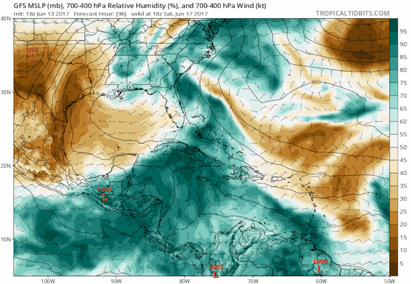
cycloneye wrote:The 18z GFS Paralell has a 997 mb strong Tropical Storm going to Mexico.

Image


I'm thinking this, just like the last few years at this time.
0 likes   

User avatar
cycloneye
Admin
Admin
Posts: 139493
Age: 67
Joined: Thu Oct 10, 2002 10:54 am
Location: San Juan, Puerto Rico

Re: Possible development in Western Caribbean

#38 Postby cycloneye » Tue Jun 13, 2017 11:40 pm

00z GFS is very slow on the evolution of system as it interacts with land and it takes to almost 200 hours to be in BOC developing slowly.
1 likes   
Visit the Caribbean-Central America Weather Thread where you can find at first post web cams,radars
and observations from Caribbean basin members Click Here

User avatar
Kingarabian
S2K Supporter
S2K Supporter
Posts: 15454
Joined: Sat Aug 08, 2009 3:06 am
Location: Honolulu, Hawaii

Re: Possible development in Western Caribbean

#39 Postby Kingarabian » Wed Jun 14, 2017 12:05 am

12Z Euro Parallel down to 998mb. Makes landfall further south, southern Mexico (as a weaker storm).
0 likes   
RIP Kobe Bryant

User avatar
Steve
S2K Supporter
S2K Supporter
Posts: 8608
Joined: Sat Apr 05, 2003 11:41 pm
Location: Not a state-caster

Re: Possible development in Western Caribbean

#40 Postby Steve » Wed Jun 14, 2017 12:15 am

And the CMC pulls it due north toward Cape San Blas and Apalachicola as a formidable system. It's been consistent but it's seems that the difference is that the front/weakness draws it up unlike EC and GFS which propagate across the Yucatán and into the BOC.
0 likes   


Return to “Talkin' Tropics”

Who is online

Users browsing this forum: Blown Away, chaser1, Chris90, gib, Google Adsense [Bot], Javlin, StPeteMike and 37 guests