2018 Tropics: Global Model Runs Discussion (Out to day 16)
Moderator: S2k Moderators
Forum rules

The posts in this forum are NOT official forecasts and should not be used as such. They are just the opinion of the poster and may or may not be backed by sound meteorological data. They are NOT endorsed by any professional institution or STORM2K. For official information, please refer to products from the National Hurricane Center and National Weather Service.

Re: 2018 Tropics: Global Model Runs Discussion (Out to day 16)
If the ensembles see lower pressure does it take awhile for the models to latch on? The reason why I’m asking is because the GFS has been showing a system form in the Central Caribbean moving NNE between Hispaniola and Puerto Rico.
0 likes

Re: 2018 Tropics: Global Model Runs Discussion (Out to day 16)
Looking at the Euro and GFS forecasted UL environment as of now, the same UL divergent environment that will bring the central Caribbean to life with convection by the middle of the week will make it hard for any well developed system to get going, it will have to wait until is out of the Caribbean north of the Greater Antilles, unless the disturbed wx stays in the western Caribbean for a while until better UL conditions take over later in the 10-14 day range. IMO.
0 likes
-
SFLcane

- S2K Supporter

- Posts: 9617
- Age: 46
- Joined: Sat Jun 05, 2010 1:44 pm
- Location: Lake Worth Florida
Re: 2018 Tropics: Global Model Runs Discussion (Out to day 16)
Lol you killed the thread NDG... 
1 likes
-
toad strangler

- S2K Supporter
- Posts: 4171
- Joined: Sun Jul 28, 2013 3:09 pm
- Location: Earth
- Contact:
Re: 2018 Tropics: Global Model Runs Discussion (Out to day 16)
SFLcane wrote:Lol you killed the thread NDG...
meh, between runs down time.
0 likes

Re: 2018 Tropics: Global Model Runs Discussion (Out to day 16)
NDG wrote:Looking at the Euro and GFS forecasted UL environment as of now, the same UL divergent environment that will bring the central Caribbean to life with convection by the middle of the week will make it hard for any well developed system to get going, it will have to wait until is out of the Caribbean north of the Greater Antilles, unless the disturbed wx stays in the western Caribbean for a while until better UL conditions take over later in the 10-14 day range. IMO.
Good observation, that is why the ops GFS is having trouble consolidating. I think it is too quick to develop the C. Caribbean area and robs the W. Caribbean area and thus delays development. You even see on the 6z the GFS developing both areas eventually. I am skeptical of the C. Caribbean being that favorable to spin up a system though since it has been very suppressed this year. The real energy potential is in the W. Caribbean with the high THCP, SSt's etc. The ops Euro seams to be resolving this better now because it has been shifting gradually to favor the W. Caribbean in the last few runs more inline with its ensembles.
I agree it will not be very strong in the W. Caribbean but I am concerned if it reaches the Gulf which is primed.
1 likes
The following post is NOT an official forecast and should not be used as such. It is just the opinion of the poster and may or may not be backed by sound meteorological data. It is NOT endorsed by any professional institution including storm2k.org For Official Information please refer to the NHC and NWS products.
Re: 2018 Tropics: Global Model Runs Discussion (Out to day 16)
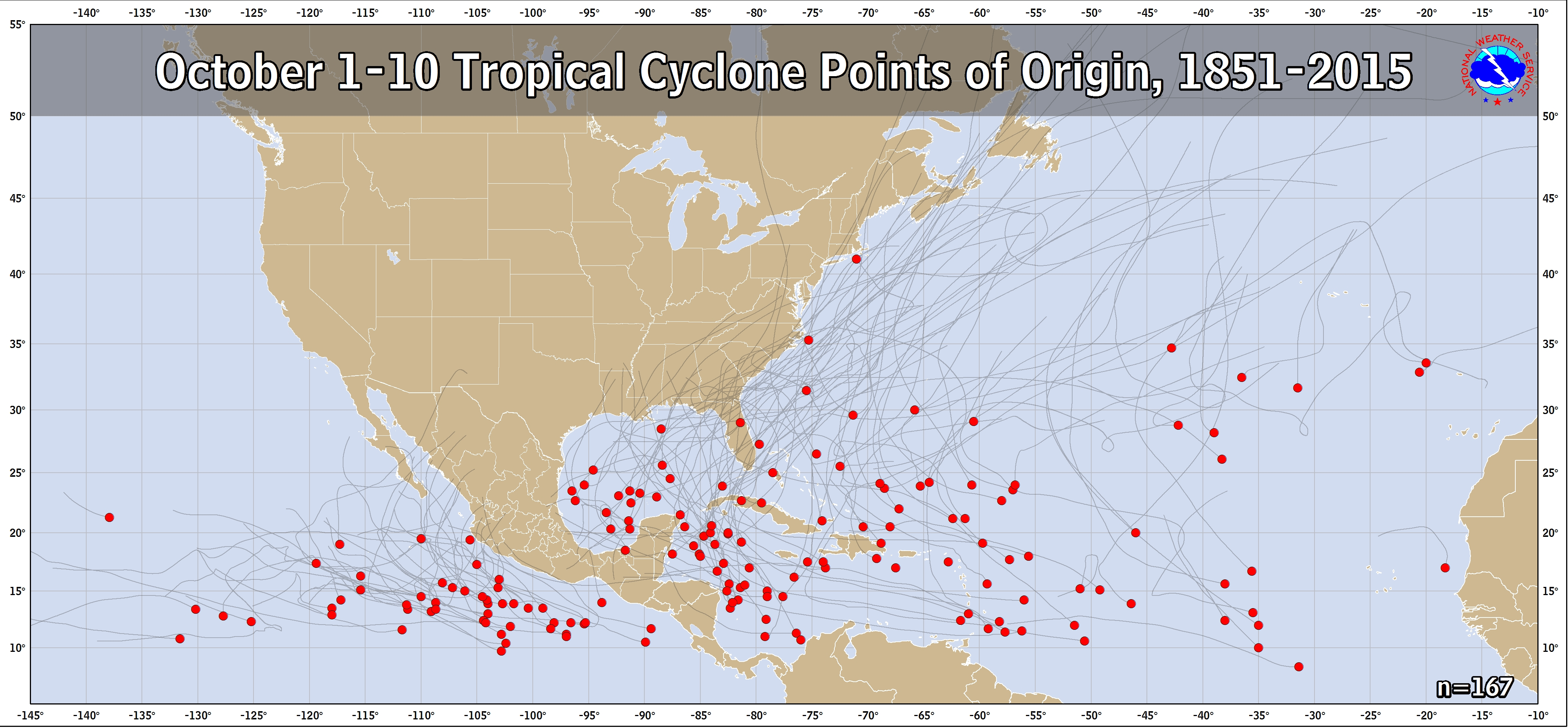
If the major 12Z operational runs’ consensus were to be east of FL, I’m going to start calling that kind of track as slightly favored should there be genesis of a surface low in the Caribbean despite what the ensembles have been showing. I mean it would be hard to not at least slightly favor a consensus of Euro, GFS, and FV3 operationals if there is a consensus whichever way they go, including an east of FL track as that wouldn’t be that rare of a track by any means for early Oct even with the further west track being more climo favored:
https://www.nhc.noaa.gov/climo/images/oct_1_10.png
Edit: One thing that I want to check is early Oct genesis climo for El Niño seasons. Maybe they have less favoring of a Caribbean to Gulf track than non-Niño seasons?? I want to find out.
Edit #2: Wherever any potential TC coming out of the Caribbean were to track, there is going to be more than the normal amount of fuel available for strengthening due to well above normal SSTs anywhere near the Bahamas and SE US. Largely due to well above normal temperatures in September, SSTs are currently close to August norms!
Last edited by LarryWx on Sun Sep 30, 2018 10:50 am, edited 5 times in total.
1 likes
Personal Forecast Disclaimer:
The posts in this forum are NOT official forecasts and should not be used as such. They are just the opinion of the poster and may or may not be backed by sound meteorological data. They are NOT endorsed by any professional institution or storm2k.org. For official information, please refer to the NHC and NWS products.
The posts in this forum are NOT official forecasts and should not be used as such. They are just the opinion of the poster and may or may not be backed by sound meteorological data. They are NOT endorsed by any professional institution or storm2k.org. For official information, please refer to the NHC and NWS products.
-
toad strangler
- S2K Supporter
- Posts: 4171
- Joined: Sun Jul 28, 2013 3:09 pm
- Location: Earth
- Contact:
Re: 2018 Tropics: Global Model Runs Discussion (Out to day 16)
LarryWx wrote:If the major 12Z operational runs’ consensus were to be east of FL, I’m going to start calling that kind of track as slightly favored should there be genesis of a surface low in the Caribbean despite what the ensembles have been showing. I mean it would be hard to not go with a consensus of Euro, GFS, and FV3 operationals if there is a consensus whichever way they go, including an east of FL track as that wouldn’t be that rare of a track by any means for early Oct even with the further west track being more climo favored:
https://www.nhc.noaa.gov/climo/images/oct_1_10.png
Edit: One thing that I want to check is early Oct genesis climo for El Niño seasons. Maybe they have less favoring of a Caribbean to Gulf track than non-Niño seasons?? I want to find out.
Yep, def on the table. A general NE motion out of the SW Caribbean through the Bahamas or even Dominican or PR is certainly plausible even though climo favors area to the W in October. GFS was even showing genesis out there...
Last edited by toad strangler on Sun Sep 30, 2018 10:46 am, edited 2 times in total.
1 likes
-
TheStormExpert

- Category 5

- Posts: 8487
- Age: 30
- Joined: Wed Feb 16, 2011 5:38 pm
- Location: Palm Beach Gardens, FL
Re: 2018 Tropics: Global Model Runs Discussion (Out to day 16)
One thing that is worth mentioning is if this area reaches the Eastern Gulf windshear has been very favorable in this region from there east into the western Atlantic off the SE U.S. coast. Not sure if it will remain this way in a week or so but I’ve noticed it’s been this favorable for the past week or so.


2 likes
The following post is NOT an official forecast and should not be used as such. It is just the opinion of the poster and may or may not be backed by sound meteorological data. It is NOT endorsed by storm2k.org.
Re: 2018 Tropics: Global Model Runs Discussion (Out to day 16)
toad strangler wrote:LarryWx wrote:If the major 12Z operational runs’ consensus were to be east of FL, I’m going to start calling that kind of track as slightly favored should there be genesis of a surface low in the Caribbean despite what the ensembles have been showing. I mean it would be hard to not go with a consensus of Euro, GFS, and FV3 operationals if there is a consensus whichever way they go, including an east of FL track as that wouldn’t be that rare of a track by any means for early Oct even with the further west track being more climo favored:
https://www.nhc.noaa.gov/climo/images/oct_1_10.png
Edit: One thing that I want to check is early Oct genesis climo for El Niño seasons. Maybe they have less favoring of a Caribbean to Gulf track than non-Niño seasons?? I want to find out.
Yep, def on the table. A general NE motion out of the SW Caribbean through the Bahamas or even Dominican or PR is certainly plausible even though climo favors area to the W in October. GFS was even showing genesis out there...
The 12Z ICON is going at hour 180 with a potentially VERY dangerous for US east coast H position in Bahamas considering the strong mid-Atlantic states ridge to the north that is then hardly budging as well as SSTs in Bahamas and surrounding areas that are well above normal and close to typical late August/early Sep maxima due to extreme warmth this entire month. Whereas this is not as common as the W Caribbean to Gulf track for significant US H hits in Oct, they are not that rare and do happen from time to time such as did Sandy, Matthew, and Hazel among others. I have to wonder just as I wondered for Florence if these very warm waters there and also in the W Atlantic further north are going to make it more difficult than normal to dislodge any ridging on or near the US east coast. Also, when I get a chance, I want to check tracks of past early to mid Octobers TCs coming out of the Caribbean during El Ninos vs non-Ninos.
By the way, two runs of the FV3 yesterday had a Carolina hit for those who didn’t see them.
2 likes
Personal Forecast Disclaimer:
The posts in this forum are NOT official forecasts and should not be used as such. They are just the opinion of the poster and may or may not be backed by sound meteorological data. They are NOT endorsed by any professional institution or storm2k.org. For official information, please refer to the NHC and NWS products.
The posts in this forum are NOT official forecasts and should not be used as such. They are just the opinion of the poster and may or may not be backed by sound meteorological data. They are NOT endorsed by any professional institution or storm2k.org. For official information, please refer to the NHC and NWS products.
-
TheStormExpert
- Category 5
- Posts: 8487
- Age: 30
- Joined: Wed Feb 16, 2011 5:38 pm
- Location: Palm Beach Gardens, FL
Re: 2018 Tropics: Global Model Runs Discussion (Out to day 16)
0 likes
The following post is NOT an official forecast and should not be used as such. It is just the opinion of the poster and may or may not be backed by sound meteorological data. It is NOT endorsed by storm2k.org.
Re: 2018 Tropics: Global Model Runs Discussion (Out to day 16)
I can certainly attest to the exceptionally warm water temps in my corner of the world. Here on October eve we're sitting in the upper 80's which is as warm as I've seen it so late in the season.
0 likes
Re: 2018 Tropics: Global Model Runs Discussion (Out to day 16)
TheStormExpert wrote::uarrow: I think the ICON is overdoing it as usual. Hasn’t been the best model.
I realize that, too, though I posted the ICON because I don’t think it is the worst model. I’m most interested in what GFS/FV3/Euro/UKMET will show. Speaking of not best model, the 12Z CMC has two W Car lows and has the stronger 2nd low in the classic NW Caribbean position that would likely later threaten W FL. That’s very much fwiw but still worth a mention.
0 likes
Personal Forecast Disclaimer:
The posts in this forum are NOT official forecasts and should not be used as such. They are just the opinion of the poster and may or may not be backed by sound meteorological data. They are NOT endorsed by any professional institution or storm2k.org. For official information, please refer to the NHC and NWS products.
The posts in this forum are NOT official forecasts and should not be used as such. They are just the opinion of the poster and may or may not be backed by sound meteorological data. They are NOT endorsed by any professional institution or storm2k.org. For official information, please refer to the NHC and NWS products.
Re: 2018 Tropics: Global Model Runs Discussion (Out to day 16)
TheStormExpert wrote:One thing that is worth mentioning is if this area reaches the Eastern Gulf windshear has been very favorable in this region from there east into the western Atlantic off the SE U.S. coast. Not sure if it will remain this way in a week or so but I’ve noticed it’s been this favorable for the past week or so.
This is a relevant point. The very warm SSTs off the US east coast/persistent E US ridging are likely a major reason for this and may not be going away anytime soon.
0 likes
Personal Forecast Disclaimer:
The posts in this forum are NOT official forecasts and should not be used as such. They are just the opinion of the poster and may or may not be backed by sound meteorological data. They are NOT endorsed by any professional institution or storm2k.org. For official information, please refer to the NHC and NWS products.
The posts in this forum are NOT official forecasts and should not be used as such. They are just the opinion of the poster and may or may not be backed by sound meteorological data. They are NOT endorsed by any professional institution or storm2k.org. For official information, please refer to the NHC and NWS products.
Re: 2018 Tropics: Global Model Runs Discussion (Out to day 16)
The 12Z GFS is the 1st in at least quite awhile showing a Gulf low as the primary low as opposed to the strongest one going east of FL. This Gulf low never gets strong but there’s no off east coast of US low on this run. Actually, there is a very weak low that tries to go east of FL but it gets blocked and then is shunted westward into the GOM.
Last edited by LarryWx on Sun Sep 30, 2018 12:07 pm, edited 2 times in total.
0 likes
Personal Forecast Disclaimer:
The posts in this forum are NOT official forecasts and should not be used as such. They are just the opinion of the poster and may or may not be backed by sound meteorological data. They are NOT endorsed by any professional institution or storm2k.org. For official information, please refer to the NHC and NWS products.
The posts in this forum are NOT official forecasts and should not be used as such. They are just the opinion of the poster and may or may not be backed by sound meteorological data. They are NOT endorsed by any professional institution or storm2k.org. For official information, please refer to the NHC and NWS products.
-
Aric Dunn
- Category 5
- Posts: 21228
- Age: 41
- Joined: Sun Sep 19, 2004 9:58 pm
- Location: Ready for the Chase.
- Contact:
Re: 2018 Tropics: Global Model Runs Discussion (Out to day 16)
LarryWx wrote:TheStormExpert wrote::uarrow: I think the ICON is overdoing it as usual. Hasn’t been the best model.
I realize that, too, though I posted the ICON because I don’t think it is the worst model. I’m most interested in what GFS/FV3/Euro/UKMET will show. Speaking of not best model, the 12Z CMC has two W Car lows and has the stronger 2nd low in the classic NW Caribbean position that would likely later threaten W FL. That’s very much fwiw but still worth a mention.
the one thing that should not be overlooked and the ICON model is doing it as well as a couple other is keeping the remnants of KIRK as the main igniter and focal point. Looking at the remnants of kirk now it is still a well defined trough axis and is heading into the western carrib right where the ICON shows it slowing down and convection starts to get enhanced which is already occurring in the western carrib now add in KIRK vorticity and walla there you have it.
the GFS and Euro have this long extended trough axis that rotates north with the axis of rotation in the western carrib. this solution is highly suspect given the convergence that will be happening in the western Carrib.
1 likes
Note: If I make a post that is brief. Please refer back to previous posts for the analysis or reasoning. I do not re-write/qoute what my initial post said each time.
If there is nothing before... then just ask
Space & Atmospheric Physicist, Embry-Riddle Aeronautical University,
I believe the sky is falling...
If there is nothing before... then just ask
Space & Atmospheric Physicist, Embry-Riddle Aeronautical University,
I believe the sky is falling...
-
Aric Dunn
- Category 5
- Posts: 21228
- Age: 41
- Joined: Sun Sep 19, 2004 9:58 pm
- Location: Ready for the Chase.
- Contact:
Re: 2018 Tropics: Global Model Runs Discussion (Out to day 16)
current 12z GFS looks more reasonable and similar to the ICON until it again start with the feedback crap and spits out multiple circs along an eastward extending trough axis from nowhere.
0 likes
Note: If I make a post that is brief. Please refer back to previous posts for the analysis or reasoning. I do not re-write/qoute what my initial post said each time.
If there is nothing before... then just ask
Space & Atmospheric Physicist, Embry-Riddle Aeronautical University,
I believe the sky is falling...
If there is nothing before... then just ask
Space & Atmospheric Physicist, Embry-Riddle Aeronautical University,
I believe the sky is falling...
-
Hurricaneman

- Category 5
- Posts: 7284
- Age: 43
- Joined: Tue Aug 31, 2004 3:24 pm
- Location: central florida
Re: 2018 Tropics: Global Model Runs Discussion (Out to day 16)
Aric Dunn wrote:current 12z GFS looks more reasonable and similar to the ICON until it again start with the feedback crap and spits out multiple circs along an eastward extending trough axis from nowhere.
Which until it stops doing that the GFS May have to be discounted even the FV3 version does it
1 likes
-
gatorcane

- S2K Supporter
- Posts: 23499
- Age: 46
- Joined: Sun Mar 13, 2005 3:54 pm
- Location: Boca Raton, FL
Re: 2018 Tropics: Global Model Runs Discussion (Out to day 16)
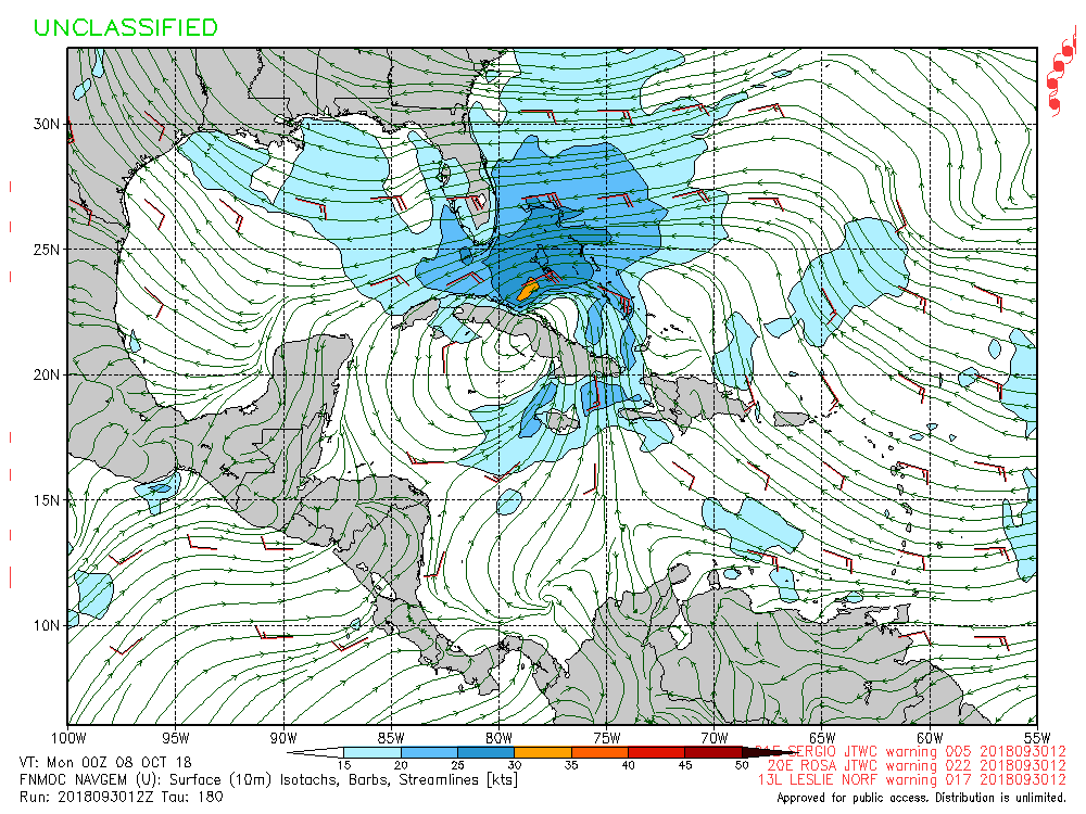
NAVGEM weaker but heading towards Bahamas:
0 likes
-
Aric Dunn
- Category 5
- Posts: 21228
- Age: 41
- Joined: Sun Sep 19, 2004 9:58 pm
- Location: Ready for the Chase.
- Contact:
Re: 2018 Tropics: Global Model Runs Discussion (Out to day 16)
Just for some reference in case anyone thinks ex KIRK won't play a big part adding to the eventual mess across the western carrib.
you can clearly see ( middle of image) remnants of KIrk still a sharp trough axis rotating around. that will slow down and convection will likely explode later tonight as it reaches the highly divergent region in the western carrib. This will be the catalyst ( and technically should be named KIRK again but likely won't assuming something develops) that gets things going.

you can clearly see ( middle of image) remnants of KIrk still a sharp trough axis rotating around. that will slow down and convection will likely explode later tonight as it reaches the highly divergent region in the western carrib. This will be the catalyst ( and technically should be named KIRK again but likely won't assuming something develops) that gets things going.
3 likes
Note: If I make a post that is brief. Please refer back to previous posts for the analysis or reasoning. I do not re-write/qoute what my initial post said each time.
If there is nothing before... then just ask
Space & Atmospheric Physicist, Embry-Riddle Aeronautical University,
I believe the sky is falling...
If there is nothing before... then just ask
Space & Atmospheric Physicist, Embry-Riddle Aeronautical University,
I believe the sky is falling...
Who is online
Users browsing this forum: No registered users and 35 guests