2021 Global Model Runs Discussion (Out thru day 16)
Moderator: S2k Moderators
Forum rules

The posts in this forum are NOT official forecasts and should not be used as such. They are just the opinion of the poster and may or may not be backed by sound meteorological data. They are NOT endorsed by any professional institution or STORM2K. For official information, please refer to products from the National Hurricane Center and National Weather Service.

Re: 2021 Global Model Runs Discussion (Out thru day 16)
What surprises me is how disciplined the GFS has been not showing consistent phantoms like it has in years past in this region. You might get one or two runs here and there but that is fine. It seems to be performing well so far. That could also be an indicator of just how bad the conditions are so it's too early to tell if the GFS has finally corrected it's bias. We will see what happens.
2 likes
The following post is NOT an official forecast and should not be used as such. It is just the opinion of the poster and may or may not be backed by sound meteorological data. It is NOT endorsed by any professional institution including storm2k.org For Official Information please refer to the NHC and NWS products.
-
Category5Kaiju

- Category 5

- Posts: 3404
- Age: 22
- Joined: Thu Dec 24, 2020 12:45 pm
- Location: Seattle
Re: 2021 Global Model Runs Discussion (Out thru day 16)
blp wrote:What surprises me is how disciplined the GFS has been not showing consistent phantoms like it has in years past in this region. You might get one or two runs here and there but that is fine. It seems to be performing well so far. That could also be an indicator of just how bad the conditions are so it's too early to tell if the GFS has finally corrected it's bias. We will see what happens.
Whatever the reason, the GFS sure does not seem to think the WPAC and EPAC will have much significant activity after the current storms in those basins leave the picture for the rest of this month either. In other words, at least according to many of the recent GFS runs, all three major NH basins fall quiet after mid-month or so. Definitely has me scratching my head.
0 likes
Unless explicitly stated, all information covered in my posts is based on my opinions and observations. Please refer to a professional meteorologist or an accredited weather research agency otherwise, especially if serious decisions must be made in the event of a potentially life-threatening tropical storm or hurricane.
-
Category5Kaiju
- Category 5
- Posts: 3404
- Age: 22
- Joined: Thu Dec 24, 2020 12:45 pm
- Location: Seattle
Re: 2021 Global Model Runs Discussion (Out thru day 16)
The GEFS's most recent run shows several pretty robust WCAR storms by the month's end; I know this is very far out in time, but if the CCKW were to pass by the basin by the middle of the month, then it would theoretically make sense for the W Atlantic to wake up some days after that occurs.
0 likes
Unless explicitly stated, all information covered in my posts is based on my opinions and observations. Please refer to a professional meteorologist or an accredited weather research agency otherwise, especially if serious decisions must be made in the event of a potentially life-threatening tropical storm or hurricane.

Re: 2021 Global Model Runs Discussion (Out thru day 16)
The past few GFS runs have been developing in the Caribbean (very long range). The latest run shifts it a little earlier coinciding with the suppression moving out. Not putting any weight on track or intensity this far out, it’s just worth noting for now.
0 likes
Kendall -> SLO -> PBC
Memorable Storms: Katrina (for its Florida landfall...) Wilma Matthew Irma
Memorable Storms: Katrina (for its Florida landfall...) Wilma Matthew Irma

Re: 2021 Global Model Runs Discussion (Out thru day 16)
Ubuntwo wrote:The past few GFS runs have been developing in the Caribbean (very long range). The latest run shifts it a little earlier coinciding with the suppression moving out. Not putting any weight on track or intensity this far out, it’s just worth noting for now.
There’s also a clear origin source for it: a tropical wave that’s around 45-50W on October 21st/22nd. That wave could make it into the Caribbean like the Gamma/Delta/Zeta/Eta/Iota precursors, or it could suffer a similar fate as 93L.
1 likes
Irene '11 Sandy '12 Hermine '16 5/15/2018 Derecho Fay '20 Isaias '20 Elsa '21 Henri '21 Ida '21
I am only a meteorology enthusiast who knows a decent amount about tropical cyclones. Look to the professional mets, the NHC, or your local weather office for the best information.
I am only a meteorology enthusiast who knows a decent amount about tropical cyclones. Look to the professional mets, the NHC, or your local weather office for the best information.
Re: 2021 Global Model Runs Discussion (Out thru day 16)
aspen wrote:Ubuntwo wrote:The past few GFS runs have been developing in the Caribbean (very long range). The latest run shifts it a little earlier coinciding with the suppression moving out. Not putting any weight on track or intensity this far out, it’s just worth noting for now.
There’s also a clear origin source for it: a tropical wave that’s around 45-50W on October 21st/22nd. That wave could make it into the Caribbean like the Gamma/Delta/Zeta/Eta/Iota precursors, or it could suffer a similar fate as 93L.
This does look like a legit source for development. The ensembles have been hinting at a low rider wave scenario sneaking into the Caribbean for the past few days.
00z Euro

00z GFS

2 likes
The following post is NOT an official forecast and should not be used as such. It is just the opinion of the poster and may or may not be backed by sound meteorological data. It is NOT endorsed by any professional institution including storm2k.org For Official Information please refer to the NHC and NWS products.

Re: 2021 Global Model Runs Discussion (Out thru day 16)
Latest 06z GFS ensemble has a bit more long-term WCar activity consisting of 2 systems: 1) homegrown WCar trouble and 2) a low rider originating from the MDR. Still nothing spectacular (or even close to spectacular), but perhaps a sign of things to come. Still, I won't pay a lot of attention to it for now until either the Euro also starts showing something or when the development is at +100 instead of +240.

1 likes
-
gatorcane

- S2K Supporter

- Posts: 23499
- Age: 46
- Joined: Sun Mar 13, 2005 3:54 pm
- Location: Boca Raton, FL
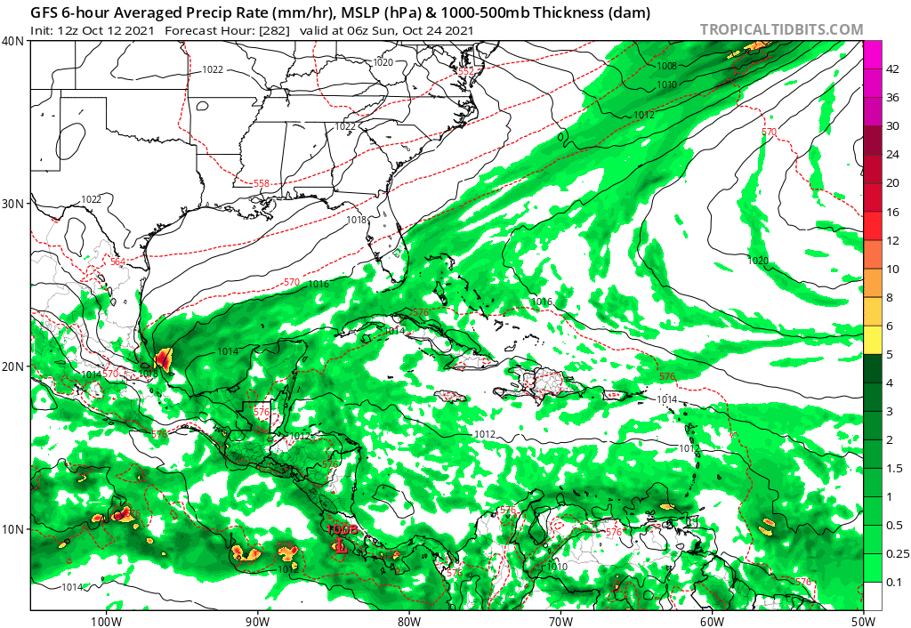
Re: 2021 Global Model Runs Discussion (Out thru day 16)
It’s way out there but no doubt the GFS has been coming alive the last several runs with possible Caribbean development. Here is the latest 12Z run:
1 likes
-
StPeteMike

- Category 1

- Posts: 375
- Joined: Thu Jun 07, 2018 11:26 pm
Re: 2021 Global Model Runs Discussion (Out thru day 16)
The past few weeks of possible Caribbean activity through the models hasn’t really caught my attention, and clearly for good reason, but this one doesn’t seem to be a phantom. By the looks of it, it generates from the mass of clouds and convection just off the coast of Africa. We shall see what shear looks like in the W Caribbean and GOM around that time, as it really hasn’t been favorable for development the last 2 weeks.
1 likes
The above post is not official and should not be used as such. It is the opinion of the poster and may or may not be backed by sound meteorological data. It is not endorsed by any professional institution or storm2k.org. For official information, please refer to the NHC and NWS products.
Re: 2021 Global Model Runs Discussion (Out thru day 16)
gatorcane wrote:It’s way out there but no doubt the GFS has been coming alive the last several runs with possible Caribbean development. Here is the latest 12Z run:
https://i.postimg.cc/qMkGZK0f/gfs-mslp-pcpn-watl-fh282-384.gif
The source for that system remains constant, even though development has been shifted to several days later. That’s a good sign this isn’t a phantom. The 12z CMC also possibly shows the precursor too: a wave around ~45W at 240hr.
0 likes
Irene '11 Sandy '12 Hermine '16 5/15/2018 Derecho Fay '20 Isaias '20 Elsa '21 Henri '21 Ida '21
I am only a meteorology enthusiast who knows a decent amount about tropical cyclones. Look to the professional mets, the NHC, or your local weather office for the best information.
I am only a meteorology enthusiast who knows a decent amount about tropical cyclones. Look to the professional mets, the NHC, or your local weather office for the best information.
Re: 2021 Global Model Runs Discussion (Out thru day 16)
StPeteMike wrote:The past few weeks of possible Caribbean activity through the models hasn’t really caught my attention, and clearly for good reason, but this one doesn’t seem to be a phantom. By the looks of it, it generates from the mass of clouds and convection just off the coast of Africa. We shall see what shear looks like in the W Caribbean and GOM around that time, as it really hasn’t been favorable for development the last 2 weeks.
It may not be a phantom and it wouldn't surprise me if there is one strong storm in late Oct, but the continued lack of ensemble support sure tells me that it could still be fake. 12Z GEFS/GEPS and 0Z EPS members give almost no support for that timeframe.
1 likes
Personal Forecast Disclaimer:
The posts in this forum are NOT official forecasts and should not be used as such. They are just the opinion of the poster and may or may not be backed by sound meteorological data. They are NOT endorsed by any professional institution or storm2k.org. For official information, please refer to the NHC and NWS products.
The posts in this forum are NOT official forecasts and should not be used as such. They are just the opinion of the poster and may or may not be backed by sound meteorological data. They are NOT endorsed by any professional institution or storm2k.org. For official information, please refer to the NHC and NWS products.
Re: 2021 Global Model Runs Discussion (Out thru day 16)
LarryWx wrote:StPeteMike wrote:The past few weeks of possible Caribbean activity through the models hasn’t really caught my attention, and clearly for good reason, but this one doesn’t seem to be a phantom. By the looks of it, it generates from the mass of clouds and convection just off the coast of Africa. We shall see what shear looks like in the W Caribbean and GOM around that time, as it really hasn’t been favorable for development the last 2 weeks.
It may not be a phantom and it wouldn't surprise me if there is one strong storm in late Oct, but the continued lack of ensemble support sure tells me that it could still be fake. 12Z GEFS/GEPS and 0Z EPS members give almost no support for that timeframe.
Larrywx, I have been tracking the source being the wave in the central Atlantic which has support from both Euro and GFS ensembles. It looks like their are variations in the long run with some showing it going out to see or dissipating before reaching. Do you see the same source on this development.
00z Euro

12z GFS

0 likes
The following post is NOT an official forecast and should not be used as such. It is just the opinion of the poster and may or may not be backed by sound meteorological data. It is NOT endorsed by any professional institution including storm2k.org For Official Information please refer to the NHC and NWS products.
Re: 2021 Global Model Runs Discussion (Out thru day 16)
12z Euro Ensembles looks more active.

3 likes
The following post is NOT an official forecast and should not be used as such. It is just the opinion of the poster and may or may not be backed by sound meteorological data. It is NOT endorsed by any professional institution including storm2k.org For Official Information please refer to the NHC and NWS products.
-
AlphaToOmega
- Category 5
- Posts: 1448
- Joined: Sat Jun 26, 2021 10:51 am
- Location: Somewhere in Massachusetts
Re: 2021 Global Model Runs Discussion (Out thru day 16)
blp wrote:LarryWx wrote:StPeteMike wrote:The past few weeks of possible Caribbean activity through the models hasn’t really caught my attention, and clearly for good reason, but this one doesn’t seem to be a phantom. By the looks of it, it generates from the mass of clouds and convection just off the coast of Africa. We shall see what shear looks like in the W Caribbean and GOM around that time, as it really hasn’t been favorable for development the last 2 weeks.
It may not be a phantom and it wouldn't surprise me if there is one strong storm in late Oct, but the continued lack of ensemble support sure tells me that it could still be fake. 12Z GEFS/GEPS and 0Z EPS members give almost no support for that timeframe.
Larrywx, I have been tracking the source being the wave in the central Atlantic which has support from both Euro and GFS ensembles. It looks like their are variations in the long run with some showing it going out to see or dissipating before reaching. Do you see the same source on this development.
00z Euro
https://i.ibb.co/23hR4W2/ecens-2021-10-12-00-Z-240-50-258-0-350-MSLP-Surface-tracks-lows.png
12z GFS
https://i.ibb.co/Hn6BHYd/gefs-2021-10-12-12-Z-240-50-258-0-350-MSLP-Surface-tracks-lows.png
Are my eyes tricking me? Is that forecasted Cape Verde activity in late October?
1 likes
Re: 2021 Global Model Runs Discussion (Out thru day 16)
blp wrote:LarryWx wrote:StPeteMike wrote:The past few weeks of possible Caribbean activity through the models hasn’t really caught my attention, and clearly for good reason, but this one doesn’t seem to be a phantom. By the looks of it, it generates from the mass of clouds and convection just off the coast of Africa. We shall see what shear looks like in the W Caribbean and GOM around that time, as it really hasn’t been favorable for development the last 2 weeks.
It may not be a phantom and it wouldn't surprise me if there is one strong storm in late Oct, but the continued lack of ensemble support sure tells me that it could still be fake. 12Z GEFS/GEPS and 0Z EPS members give almost no support for that timeframe.
Larrywx, I have been tracking the source being the wave in the central Atlantic which has support from both Euro and GFS ensembles. It looks like their are variations in the long run with some showing it going out to see or dissipating before reaching. Do you see the same source on this development.
00z Euro
https://i.ibb.co/23hR4W2/ecens-2021-10-12-00-Z-240-50-258-0-350-MSLP-Surface-tracks-lows.png
12z GFS
https://i.ibb.co/Hn6BHYd/gefs-2021-10-12-12-Z-240-50-258-0-350-MSLP-Surface-tracks-lows.png
It is hard to see on my source as it just shows lows of under 1004 mb and hardly any of them are showing up.
0 likes
Personal Forecast Disclaimer:
The posts in this forum are NOT official forecasts and should not be used as such. They are just the opinion of the poster and may or may not be backed by sound meteorological data. They are NOT endorsed by any professional institution or storm2k.org. For official information, please refer to the NHC and NWS products.
The posts in this forum are NOT official forecasts and should not be used as such. They are just the opinion of the poster and may or may not be backed by sound meteorological data. They are NOT endorsed by any professional institution or storm2k.org. For official information, please refer to the NHC and NWS products.
Re: 2021 Global Model Runs Discussion (Out thru day 16)
AlphaToOmega wrote:blp wrote:LarryWx wrote:
It may not be a phantom and it wouldn't surprise me if there is one strong storm in late Oct, but the continued lack of ensemble support sure tells me that it could still be fake. 12Z GEFS/GEPS and 0Z EPS members give almost no support for that timeframe.
Larrywx, I have been tracking the source being the wave in the central Atlantic which has support from both Euro and GFS ensembles. It looks like their are variations in the long run with some showing it going out to see or dissipating before reaching. Do you see the same source on this development.
00z Euro
https://i.ibb.co/23hR4W2/ecens-2021-10-12-00-Z-240-50-258-0-350-MSLP-Surface-tracks-lows.png
12z GFS
https://i.ibb.co/Hn6BHYd/gefs-2021-10-12-12-Z-240-50-258-0-350-MSLP-Surface-tracks-lows.png
Are my eyes tricking me? Is that forecasted Cape Verde activity in late October?
Probably not. I remember that the precursors for Eta and Iota seemed like they had the potential to develop around the Lesser Antilles, possibly in the far western MDR, but both waited until the central Caribbean before consolidating into a TC. This could be a similar situation.
5 likes
Irene '11 Sandy '12 Hermine '16 5/15/2018 Derecho Fay '20 Isaias '20 Elsa '21 Henri '21 Ida '21
I am only a meteorology enthusiast who knows a decent amount about tropical cyclones. Look to the professional mets, the NHC, or your local weather office for the best information.
I am only a meteorology enthusiast who knows a decent amount about tropical cyclones. Look to the professional mets, the NHC, or your local weather office for the best information.
Re: 2021 Global Model Runs Discussion (Out thru day 16)
18z GFS develops this. That is four runs in a row. Still in long range though. This would be an ultimate sleeper if it pans out. If anything GFS is sending a strong signal of favorable conditions week of the 25th.
0 likes
The following post is NOT an official forecast and should not be used as such. It is just the opinion of the poster and may or may not be backed by sound meteorological data. It is NOT endorsed by any professional institution including storm2k.org For Official Information please refer to the NHC and NWS products.
Re: 2021 Global Model Runs Discussion (Out thru day 16)
blp wrote:12z Euro Ensembles looks more active.
https://i.ibb.co/vZwFBBB/ecens-2021-10-12-12-Z-240-50-258-0-350-MSLP-Surface-tracks-lows.png
~30-40% of EPS members develop in the western basin through day 15.
3 likes
Kendall -> SLO -> PBC
Memorable Storms: Katrina (for its Florida landfall...) Wilma Matthew Irma
Memorable Storms: Katrina (for its Florida landfall...) Wilma Matthew Irma
Re: 2021 Global Model Runs Discussion (Out thru day 16)
By day 10. the GFS, CMC, and ICON all have a sharp wave axis just outside the Caribbean.
The GFS depicts it tracking into a solid environment through day 16. Run to run variation remains very high but this is the 5th consecutive run to show development.
The GFS depicts it tracking into a solid environment through day 16. Run to run variation remains very high but this is the 5th consecutive run to show development.
Last edited by Ubuntwo on Wed Oct 13, 2021 12:36 am, edited 1 time in total.
3 likes
Kendall -> SLO -> PBC
Memorable Storms: Katrina (for its Florida landfall...) Wilma Matthew Irma
Memorable Storms: Katrina (for its Florida landfall...) Wilma Matthew Irma
Re: 2021 Global Model Runs Discussion (Out thru day 16)
Oh boy! 

1 likes
The following post is NOT an official forecast and should not be used as such. It is just the opinion of the poster and may or may not be backed by sound meteorological data. It is NOT endorsed by any professional institution including storm2k.org For Official Information please refer to the NHC and NWS products.
Who is online
Users browsing this forum: No registered users and 38 guests