2021 Global Model Runs Discussion (Out thru day 16)

This is the general tropical discussion area. Anyone can take their shot at predicting a storms path.

Moderator: S2k Moderators

Forum rules

The posts in this forum are NOT official forecasts and should not be used as such. They are just the opinion of the poster and may or may not be backed by sound meteorological data. They are NOT endorsed by any professional institution or STORM2K. For official information, please refer to products from the National Hurricane Center and National Weather Service.

Help Support Storm2K
Message
Author
User avatar
blp
Category 5
Category 5
Posts: 2807
Age: 45
Joined: Thu Sep 09, 2004 7:51 pm
Location: Miami, FL
Contact:

Re: 2021 Global Model Runs Discussion (Out thru day 16)

#2061 Postby blp » Wed Oct 13, 2021 12:24 am

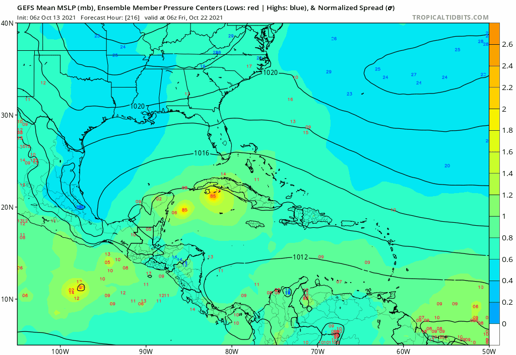
Ubuntwo wrote:By day 10. the GFS, CMC, and ICON all have a sharp wave axis just outside the Caribbean.

The GFS depicts it tracking through a solid environment through day 16. Run to run variation remains very high but this is the 5th consecutive run to show development.
https://imgur.com/E1wryKQ


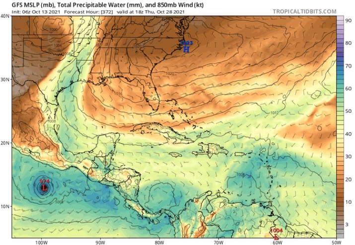
Yep this one starting to look for real. Let's see if the Euro bites.
2 likes   
The following post is NOT an official forecast and should not be used as such. It is just the opinion of the poster and may or may not be backed by sound meteorological data. It is NOT endorsed by any professional institution including storm2k.org For Official Information please refer to the NHC and NWS products.

User avatar
weeniepatrol
Category 3
Category 3
Posts: 866
Joined: Sat Aug 22, 2020 5:30 pm
Location: WA State

Re: 2021 Global Model Runs Discussion (Out thru day 16)

#2062 Postby weeniepatrol » Wed Oct 13, 2021 12:27 am

blp wrote:Oh boy! :eek:


:lol:
1 likes   

User avatar
blp
Category 5
Category 5
Posts: 2807
Age: 45
Joined: Thu Sep 09, 2004 7:51 pm
Location: Miami, FL
Contact:

Re: 2021 Global Model Runs Discussion (Out thru day 16)

#2063 Postby blp » Wed Oct 13, 2021 12:43 am

Closeup of CMC as Ubuntwo pointed out. Similar to the GFS but stronger.

Image
1 likes   
The following post is NOT an official forecast and should not be used as such. It is just the opinion of the poster and may or may not be backed by sound meteorological data. It is NOT endorsed by any professional institution including storm2k.org For Official Information please refer to the NHC and NWS products.

Monsoonjr99
Tropical Storm
Tropical Storm
Posts: 210
Age: 25
Joined: Fri Sep 21, 2018 11:22 pm
Location: Inland Empire, SoCal

Re: 2021 Global Model Runs Discussion (Out thru day 16)

#2064 Postby Monsoonjr99 » Wed Oct 13, 2021 3:05 am

With Pamela underperforming big time, the models had to have been stuck in El Nino mode, and were probably just as out to lunch with showing a dead Atlantic this month.
1 likes   
The posts in this forum are NOT official forecasts and should not be used as such. They are just the opinion of the poster and may or may not be backed by sound meteorological data. They are NOT endorsed by any professional institution or STORM2K. For official information, please refer to products from the NHC and NWS.

Some Californian who codes things and tracks weather.

Kay '22, Hilary '23

User avatar
kevin
Category 5
Category 5
Posts: 1773
Age: 25
Joined: Wed Aug 28, 2019 4:35 am

Re: 2021 Global Model Runs Discussion (Out thru day 16)

#2065 Postby kevin » Wed Oct 13, 2021 4:36 am

The model bust regarding Pamela which will, according to the latest advisory, make landfall as a cat 1 instead of a high end MH that seemed to be in the cards a few days ago, also has a big impact on the Atlantic. Weaker Pamela = less shear in the Atlantic = easier TC genesis the coming week(s). Now that more models are picking up on it, I'm interested to see what they will do with the MDR system and the homegrown system the coming days.
7 likes   

User avatar
aspen
Category 5
Category 5
Posts: 8057
Joined: Sat Oct 12, 2019 7:10 pm
Location: Connecticut, USA

Re: 2021 Global Model Runs Discussion (Out thru day 16)

#2066 Postby aspen » Wed Oct 13, 2021 6:04 am

06z GFS shows the precursor wave, but doesn’t develop it this time, instead developing a strong TS/weak hurricane in the subtropics in the long-range.
0 likes   
Irene '11 Sandy '12 Hermine '16 5/15/2018 Derecho Fay '20 Isaias '20 Elsa '21 Henri '21 Ida '21

I am only a meteorology enthusiast who knows a decent amount about tropical cyclones. Look to the professional mets, the NHC, or your local weather office for the best information.

User avatar
SFLcane
S2K Supporter
S2K Supporter
Posts: 9617
Age: 46
Joined: Sat Jun 05, 2010 1:44 pm
Location: Lake Worth Florida

Re: 2021 Global Model Runs Discussion (Out thru day 16)

#2067 Postby SFLcane » Wed Oct 13, 2021 7:00 am

aspen wrote:06z GFS shows the precursor wave, but doesn’t develop it this time, instead developing a strong TS/weak hurricane in the subtropics in the long-range.


Meh pure fantasy from the gfs. No other models even remotely shows this outside of some extreme long range ensembles. The jet stream is fully draped over gulf and Florida. I honestly think if anything develops its likely to stay in the Caribbean. The gfs will keep pumping 300hr storms till January.
0 likes   

User avatar
Category5Kaiju
Category 5
Category 5
Posts: 3404
Age: 22
Joined: Thu Dec 24, 2020 12:45 pm
Location: Seattle

Re: 2021 Global Model Runs Discussion (Out thru day 16)

#2068 Postby Category5Kaiju » Wed Oct 13, 2021 7:02 am

aspen wrote:06z GFS shows the precursor wave, but doesn’t develop it this time, instead developing a strong TS/weak hurricane in the subtropics in the long-range.


Honestly, this run is a bit sus; it shows two areas of robust vorticity spin up off of the west coast of Central America and linger there while growing more intense; given we are entering a moderate La Nina state with Pamela completely busting and underperforming contrary to expectations, I honestly do not think this is even a possible outcome. These two areas of vorticity would likely not survive for long or not even form in the EPAC at all, if anything that area of disturbed weather would likely be favored in the WCAR especially later this month, which is why imho the 00z run is a more plausible run than the 06z. Just my take on this though.
0 likes   
Unless explicitly stated, all information covered in my posts is based on my opinions and observations. Please refer to a professional meteorologist or an accredited weather research agency otherwise, especially if serious decisions must be made in the event of a potentially life-threatening tropical storm or hurricane.

User avatar
gatorcane
S2K Supporter
S2K Supporter
Posts: 23499
Age: 46
Joined: Sun Mar 13, 2005 3:54 pm
Location: Boca Raton, FL

Re: 2021 Global Model Runs Discussion (Out thru day 16)

#2069 Postby gatorcane » Wed Oct 13, 2021 7:44 am

06Z GFS ensembles in the long-range. You can track the wave where it shows some weak lows just SE of the Lesser Antilles which move west into the Caribbean with some development. This one may not be a phantom since other models are picking up on the wave also.

Image
2 likes   

User avatar
SFLcane
S2K Supporter
S2K Supporter
Posts: 9617
Age: 46
Joined: Sat Jun 05, 2010 1:44 pm
Location: Lake Worth Florida

Re: 2021 Global Model Runs Discussion (Out thru day 16)

#2070 Postby SFLcane » Wed Oct 13, 2021 9:15 am

Until I see other operational models come onboard I will say it’s some good ole Caribbean GFS…

Image
1 likes   

User avatar
SFLcane
S2K Supporter
S2K Supporter
Posts: 9617
Age: 46
Joined: Sat Jun 05, 2010 1:44 pm
Location: Lake Worth Florida

Re: 2021 Global Model Runs Discussion (Out thru day 16)

#2071 Postby SFLcane » Wed Oct 13, 2021 9:39 am

Gfs sends a strong front all the way into the Caribbean which in a sense would put the nail into the coffin.

Image
Last edited by SFLcane on Wed Oct 13, 2021 9:43 am, edited 1 time in total.
0 likes   

User avatar
Teban54
Category 5
Category 5
Posts: 1977
Joined: Sat May 19, 2018 1:19 pm

Re: 2021 Global Model Runs Discussion (Out thru day 16)

#2072 Postby Teban54 » Wed Oct 13, 2021 9:42 am

SFLcane wrote:Gfs sends a strong front all the way into the Caribbean which in a sense would put the nail into the coffin.

https://i.postimg.cc/tgfZfW7H/E5299420-B94-E-40-EE-900-C-7922-BA5-D8626.jpg

Until I see other operational models come onboard I will say it’s some good ole strong front GFS…
Image
2 likes   

User avatar
Category5Kaiju
Category 5
Category 5
Posts: 3404
Age: 22
Joined: Thu Dec 24, 2020 12:45 pm
Location: Seattle

Re: 2021 Global Model Runs Discussion (Out thru day 16)

#2073 Postby Category5Kaiju » Wed Oct 13, 2021 9:58 am

SFLcane wrote:Gfs sends a strong front all the way into the Caribbean which in a sense would put the nail into the coffin.

https://i.postimg.cc/tgfZfW7H/E5299420-B94-E-40-EE-900-C-7922-BA5-D8626.jpg


That run though isn’t necessarily something I personally would put a lot of stock on, given how Pamela greatly underperformed (thus showing how the EPAC conditions as of now are not very favorable, which would be expected to grow more unfavorable as the month elapses and the La Niña becomes more firmly entrenched) yet that run shows an El Nino-like pattern with a robust vorticity right off the western coast of Central America and ripping Atlantic winds.
2 likes   
Unless explicitly stated, all information covered in my posts is based on my opinions and observations. Please refer to a professional meteorologist or an accredited weather research agency otherwise, especially if serious decisions must be made in the event of a potentially life-threatening tropical storm or hurricane.

User avatar
aspen
Category 5
Category 5
Posts: 8057
Joined: Sat Oct 12, 2019 7:10 pm
Location: Connecticut, USA

Re: 2021 Global Model Runs Discussion (Out thru day 16)

#2074 Postby aspen » Wed Oct 13, 2021 10:35 am

SFLcane wrote:Gfs sends a strong front all the way into the Caribbean which in a sense would put the nail into the coffin.

https://i.postimg.cc/tgfZfW7H/E5299420-B94-E-40-EE-900-C-7922-BA5-D8626.jpg

A low-latitude October EPac hurricane and suppressive conditions in the Atlantic? Looks like the other kind of GFS bias to me. It still shows the precursor distance despite that, supporting the potential that this isn’t a phantom.
1 likes   
Irene '11 Sandy '12 Hermine '16 5/15/2018 Derecho Fay '20 Isaias '20 Elsa '21 Henri '21 Ida '21

I am only a meteorology enthusiast who knows a decent amount about tropical cyclones. Look to the professional mets, the NHC, or your local weather office for the best information.

AutoPenalti
Category 5
Category 5
Posts: 3950
Age: 27
Joined: Mon Aug 17, 2015 4:16 pm
Location: Ft. Lauderdale, Florida

Re: 2021 Global Model Runs Discussion (Out thru day 16)

#2075 Postby AutoPenalti » Wed Oct 13, 2021 10:46 am

SFLcane wrote:Gfs sends a strong front all the way into the Caribbean which in a sense would put the nail into the coffin.

https://i.postimg.cc/tgfZfW7H/E5299420-B94-E-40-EE-900-C-7922-BA5-D8626.jpg

So wait, you put more weight into the same 384 forecast of a cold front than a formation of a TC in the Caribbean?
4 likes   
The posts in this forum are NOT official forecasts and should not be used as such. They are just the opinion of the poster and may or may not be backed by sound meteorological data. They are NOT endorsed by any professional institution or STORM2K. For official information, please refer to products from the NHC and NWS.


Model Runs Cheat Sheet:
GFS (5:30 AM/PM, 11:30 AM/PM)
HWRF, GFDL, UKMET, NAVGEM (6:30-8:00 AM/PM, 12:30-2:00 AM/PM)
ECMWF (1:45 AM/PM)

TCVN
is a weighted averaged

LarryWx
Category 5
Category 5
Posts: 5743
Joined: Sun Sep 07, 2003 2:04 pm
Location: GA

Re: 2021 Global Model Runs Discussion (Out thru day 16)

#2076 Postby LarryWx » Wed Oct 13, 2021 11:34 am

Fwiw, this is much earlier in the GFS:

Image
0 likes   
Personal Forecast Disclaimer:
The posts in this forum are NOT official forecasts and should not be used as such. They are just the opinion of the poster and may or may not be backed by sound meteorological data. They are NOT endorsed by any professional institution or storm2k.org. For official information, please refer to the NHC and NWS products.

User avatar
Ubuntwo
Category 5
Category 5
Posts: 1089
Age: 30
Joined: Thu Oct 05, 2017 10:41 pm

Re: 2021 Global Model Runs Discussion (Out thru day 16)

#2077 Postby Ubuntwo » Wed Oct 13, 2021 11:39 am

LarryWx wrote:Fwiw, this is much earlier in the GFS:

https://i.imgur.com/itT2LNb.png

That is a wave currently in the MDR which past runs developed Pacific side. No other model spins it up except the ICON (to some extent). It has mild support in the Euro and GFS ensembles.
0 likes   
Kendall -> SLO -> PBC

Memorable Storms: Katrina (for its Florida landfall...) Wilma Matthew Irma

User avatar
aspen
Category 5
Category 5
Posts: 8057
Joined: Sat Oct 12, 2019 7:10 pm
Location: Connecticut, USA

Re: 2021 Global Model Runs Discussion (Out thru day 16)

#2078 Postby aspen » Wed Oct 13, 2021 12:13 pm

12z GFS is very quiet worldwide, besides the thing that tries spinning up over the Yucatán and the precursor wave to the WCar system showing up but not developing.

Edit: actually, there’s a long-range WPac system (last run didn’t have any) and maybe something trying to develop on the EPac side of Central America
Last edited by aspen on Wed Oct 13, 2021 12:15 pm, edited 1 time in total.
0 likes   
Irene '11 Sandy '12 Hermine '16 5/15/2018 Derecho Fay '20 Isaias '20 Elsa '21 Henri '21 Ida '21

I am only a meteorology enthusiast who knows a decent amount about tropical cyclones. Look to the professional mets, the NHC, or your local weather office for the best information.

User avatar
Category5Kaiju
Category 5
Category 5
Posts: 3404
Age: 22
Joined: Thu Dec 24, 2020 12:45 pm
Location: Seattle

Re: 2021 Global Model Runs Discussion (Out thru day 16)

#2079 Postby Category5Kaiju » Wed Oct 13, 2021 12:13 pm

Whoa, those are some pretty potent GEFS ensemble signals for the potential WCAR disturbance around the 20th....and it looks to take that classic late season NE curve toward, you guess it....Florida. :eek:
0 likes   
Unless explicitly stated, all information covered in my posts is based on my opinions and observations. Please refer to a professional meteorologist or an accredited weather research agency otherwise, especially if serious decisions must be made in the event of a potentially life-threatening tropical storm or hurricane.

User avatar
blp
Category 5
Category 5
Posts: 2807
Age: 45
Joined: Thu Sep 09, 2004 7:51 pm
Location: Miami, FL
Contact:

Re: 2021 Global Model Runs Discussion (Out thru day 16)

#2080 Postby blp » Wed Oct 13, 2021 12:18 pm

12z GEFS much more excited about the earlier timeframe as well. Go figure today everything is getting shifted forward. :roll:

This just tells me that something is going to pop up soon. I cannot envision nothing happening down there with all the positive variables.

Image
Last edited by blp on Wed Oct 13, 2021 12:21 pm, edited 1 time in total.
0 likes   
The following post is NOT an official forecast and should not be used as such. It is just the opinion of the poster and may or may not be backed by sound meteorological data. It is NOT endorsed by any professional institution including storm2k.org For Official Information please refer to the NHC and NWS products.


Return to “Talkin' Tropics”

Who is online

Users browsing this forum: Google Adsense [Bot], Hurricane2022, IsabelaWeather, janwinatl, Lizzytiz1, MetroMike, Old-TimeCane, skyline385, Stratton23 and 57 guests