2021 Indicators: SST's / SAL / MSLP / Shear / Steering / Instability / Sat Images
Moderator: S2k Moderators
Forum rules

The posts in this forum are NOT official forecasts and should not be used as such. They are just the opinion of the poster and may or may not be backed by sound meteorological data. They are NOT endorsed by any professional institution or STORM2K. For official information, please refer to products from the National Hurricane Center and National Weather Service.
Re: 2021 Indicators: SST's / SAL / MSLP / Shear / Steering / Instability / Sat Images
12Z GEFS and other models have been suggesting a "Ridge Over Troubled Waters" pattern for the second week in Oct. CONUS, esp. FL, will need to watch that period if that verifies per Nina climo, especially coming from below.
1 likes
Personal Forecast Disclaimer:
The posts in this forum are NOT official forecasts and should not be used as such. They are just the opinion of the poster and may or may not be backed by sound meteorological data. They are NOT endorsed by any professional institution or storm2k.org. For official information, please refer to the NHC and NWS products.
The posts in this forum are NOT official forecasts and should not be used as such. They are just the opinion of the poster and may or may not be backed by sound meteorological data. They are NOT endorsed by any professional institution or storm2k.org. For official information, please refer to the NHC and NWS products.
-
CyclonicFury

- Category 5

- Posts: 1975
- Age: 25
- Joined: Sun Jul 02, 2017 12:32 pm
- Location: NC
- Contact:
Re: 2021 Indicators: SST's / SAL / MSLP / Shear / Steering / Instability / Sat Images
Category5Kaiju wrote:CyclonicFury wrote:Years since 1980 with negative ONI for September-October-November (SON) and October/November hurricanes in the Gulf of Mexico and Caribbean:
1981: Katrina
1983: None
1984: None
1985: Juan, Kate
1988: Joan
1989: Jerry
1992: None
1995: Opal, Roxanne
1996: Lili, Marco
1998: Mitch
1999: Irene, Jose, Lenny
2000: Keith
2001: Iris, Michelle
2005: Stan, Wilma, Beta
2007: None
2008: Omar, Paloma
2010: Paula, Richard, Tomas
2011: Rina
2013: None
2016: Matthew, Otto
2017: Nate
2020: Gamma, Delta, Zeta, Eta, Iota
18 of 22 -ENSO years since 1980 had at least one hurricane active in the Gulf of Mexico or Caribbean in October or November. It's interesting to note that the only -ENSO years that did not see a late-season hurricane in the Caribbean or Gulf of Mexico all had below-average ACE totals and were some of the least active -ENSO years. Based on climatology of -ENSO years, there is a very strong chance we see at least one hurricane in the Caribbean or Gulf of Mexico in October or November.
Wait, 1992 was a -ENSO year? I thought it was a moderate El Nino
It seems as if 1992 being an El Niño is one of the most common misconceptions in tropical weather, probably because it was a quiet Atlantic season with Andrew, the classic "it only takes one" season. The EPAC was also very active that year. I have seen some definitions consider 1991-1995 to be a protracted +ENSO event since the SOI was mostly negative during that time. However, from an ocean standpoint, Niño 3.4 was cooler than normal for much of the fall of 1992 - and ONI for SON 1992 was negative. 1992 definitely was not a typical -ENSO year though, kind of like the inverse 2004.
2 likes
NCSU B.S. in Meteorology Class of 2021. Tropical weather blogger at http://www.cyclonicfury.com. My forecasts and thoughts are NOT official, for official forecasts please consult the National Hurricane Center.
-
Category5Kaiju

- Category 5
- Posts: 3404
- Age: 22
- Joined: Thu Dec 24, 2020 12:45 pm
- Location: Seattle
Re: 2021 Indicators: SST's / SAL / MSLP / Shear / Steering / Instability / Sat Images
CyclonicFury wrote:Category5Kaiju wrote:CyclonicFury wrote:Years since 1980 with negative ONI for September-October-November (SON) and October/November hurricanes in the Gulf of Mexico and Caribbean:
1981: Katrina
1983: None
1984: None
1985: Juan, Kate
1988: Joan
1989: Jerry
1992: None
1995: Opal, Roxanne
1996: Lili, Marco
1998: Mitch
1999: Irene, Jose, Lenny
2000: Keith
2001: Iris, Michelle
2005: Stan, Wilma, Beta
2007: None
2008: Omar, Paloma
2010: Paula, Richard, Tomas
2011: Rina
2013: None
2016: Matthew, Otto
2017: Nate
2020: Gamma, Delta, Zeta, Eta, Iota
18 of 22 -ENSO years since 1980 had at least one hurricane active in the Gulf of Mexico or Caribbean in October or November. It's interesting to note that the only -ENSO years that did not see a late-season hurricane in the Caribbean or Gulf of Mexico all had below-average ACE totals and were some of the least active -ENSO years. Based on climatology of -ENSO years, there is a very strong chance we see at least one hurricane in the Caribbean or Gulf of Mexico in October or November.
Wait, 1992 was a -ENSO year? I thought it was a moderate El Nino
It seems as if 1992 being an El Niño is one of the most common misconceptions in tropical weather, probably because it was a quiet Atlantic season with Andrew, the classic "it only takes one" season. The EPAC was also very active that year. I have seen some definitions consider 1991-1995 to be a protracted +ENSO event since the SOI was mostly negative during that time. However, from an ocean standpoint, Niño 3.4 was cooler than normal for much of the fall of 1992 - and ONI for SON 1992 was negative. 1992 definitely was not a typical -ENSO year though, kind of like the inverse 2004.
Oh ok, something cool and new I learned today, thanks! It is rather interesting to see how many of the -ENSO years that did not feature October/November hurricanes ended up as very weak years in the end regarding ACE. Also, interesting to see 1983 and 2013 there...
1 likes
Unless explicitly stated, all information covered in my posts is based on my opinions and observations. Please refer to a professional meteorologist or an accredited weather research agency otherwise, especially if serious decisions must be made in the event of a potentially life-threatening tropical storm or hurricane.
-
SFLcane

- S2K Supporter

- Posts: 9617
- Age: 46
- Joined: Sat Jun 05, 2010 1:44 pm
- Location: Lake Worth Florida
Re: 2021 Indicators: SST's / SAL / MSLP / Shear / Steering / Instability / Sat Images
LarryWx wrote:12Z GEFS and other models have been suggesting a "Ridge Over Troubled Waters" pattern for the second week in Oct. CONUS, esp. FL, will need to watch that period if that verifies per Nina climo, especially coming from below.
Fire!
0 likes
-
AlphaToOmega
- Category 5
- Posts: 1448
- Joined: Sat Jun 26, 2021 10:51 am
- Location: Somewhere in Massachusetts
Re: 2021 Indicators: SST's / SAL / MSLP / Shear / Steering / Instability / Sat Images
IF we are going to trust the CFS, it is starting to show development in October. This is starting to agree more with the long-term signal it is forecasting; however, I would still be extremely skeptical of model runs 400+ hours out, no less a run from a model designed for the climate.
Last edited by AlphaToOmega on Wed Sep 29, 2021 2:50 pm, edited 2 times in total.
0 likes

Re: 2021 Indicators: SST's / SAL / MSLP / Shear / Steering / Instability / Sat Images
Regarding the CFS, it's not designed to tell you where a story path will go on a given day, or take snapshots of, it's best taken as a whole. It's done well as far as trends, it can tell you whether to expect a lot of activity, or little; it can also tell you whether you'll have strong or weak storms (cautioning that the resolution is extremely low, and if you take the pressure at face value, everything is a tropical storm) and its always good to watch over days worth of runs, rather than an individual one. Most climate models actually do have 12h data runs (though most aren't publicly available) which is where they derive the averages from in the first place--it shows storms, or the absence of, based on conditions it's showing. The weekly averages on TropicalTidbits are also showing heavy shear over the Caribbean practically the entirety of October.
I generally loop them in their entirety, ignoring the days (other than seeing what week or month I'm in) and look at the broader activity trends, though it has been accurate a month or so out with some more significant hurricanes.
Category5Kaiju wrote:CyclonicFury wrote:Category5Kaiju wrote:
Wait, 1992 was a -ENSO year? I thought it was a moderate El Nino
It seems as if 1992 being an El Niño is one of the most common misconceptions in tropical weather, probably because it was a quiet Atlantic season with Andrew, the classic "it only takes one" season. The EPAC was also very active that year. I have seen some definitions consider 1991-1995 to be a protracted +ENSO event since the SOI was mostly negative during that time. However, from an ocean standpoint, Niño 3.4 was cooler than normal for much of the fall of 1992 - and ONI for SON 1992 was negative. 1992 definitely was not a typical -ENSO year though, kind of like the inverse 2004.
Oh ok, something cool and new I learned today, thanks! It is rather interesting to see how many of the -ENSO years that did not feature October/November hurricanes ended up as very weak years in the end regarding ACE. Also, interesting to see 1983 and 2013 there...
Something I can add to this, there was a paper that I read some time ago that both 1982-84 and 1991-93 saw reductions in hurricane activity due to significant volcanic activity--Pinatubo in 1991 and if I remember correctly, one in Mexico in 1982.
edit: found it https://agupubs.onlinelibrary.wiley.com/doi/10.1029/2011JD016716
3 likes
The above post is not official and should not be used as such. It is the opinion of the poster and may or may not be backed by sound meteorological data. It is not endorsed by any professional institution or storm2k.org. For official information, please refer to the NHC and NWS products.
-
CyclonicFury
- Category 5
- Posts: 1975
- Age: 25
- Joined: Sun Jul 02, 2017 12:32 pm
- Location: NC
- Contact:
Re: 2021 Indicators: SST's / SAL / MSLP / Shear / Steering / Instability / Sat Images
While the CFS was somewhat correct about the Caribbean wind shear for September being higher than normal, it massively overestimated wind shear in the MDR. I'm pretty sure it overestimated shear in August as well. It shows relatively high shear over the Caribbean in October, which is likely why it is bearish on activity, though I am very skeptical that will happen considering it is a La Niña year and CFS shear forecasts have not been very accurate.
Observed shear from September 1-27

CFS predicted shear (runs from August 25-28)

Considering the MJO as well as -ENSO climatology (with 18 of 22 -ENSO years since 1980 having a hurricane in the Caribbean or GoM during Oct/Nov), that would suggest an elevated risk of hurricane formation there, even if the first week of October doesn't look like it will have any development in that region.
Observed shear from September 1-27
CFS predicted shear (runs from August 25-28)
Considering the MJO as well as -ENSO climatology (with 18 of 22 -ENSO years since 1980 having a hurricane in the Caribbean or GoM during Oct/Nov), that would suggest an elevated risk of hurricane formation there, even if the first week of October doesn't look like it will have any development in that region.
6 likes
NCSU B.S. in Meteorology Class of 2021. Tropical weather blogger at http://www.cyclonicfury.com. My forecasts and thoughts are NOT official, for official forecasts please consult the National Hurricane Center.


Re: 2021 Indicators: SST's / SAL / MSLP / Shear / Steering / Instability / Sat Images
1 likes
blonde stacey (xe/xem/xir)
-
tolakram
- Admin

- Posts: 19171
- Age: 60
- Joined: Sun Aug 27, 2006 8:23 pm
- Location: Florence, KY (name is Mark)
Re: 2021 Indicators: SST's / SAL / MSLP / Shear / Steering / Instability / Sat Images
0 likes
M a r k
- - - - -
Join us in chat: Storm2K Chatroom Invite. Android and IOS apps also available.
The posts in this forum are NOT official forecasts and should not be used as such. Posts are NOT endorsed by any professional institution or STORM2K.org. For official information and forecasts, please refer to NHC and NWS products.
-
AlphaToOmega
- Category 5
- Posts: 1448
- Joined: Sat Jun 26, 2021 10:51 am
- Location: Somewhere in Massachusetts
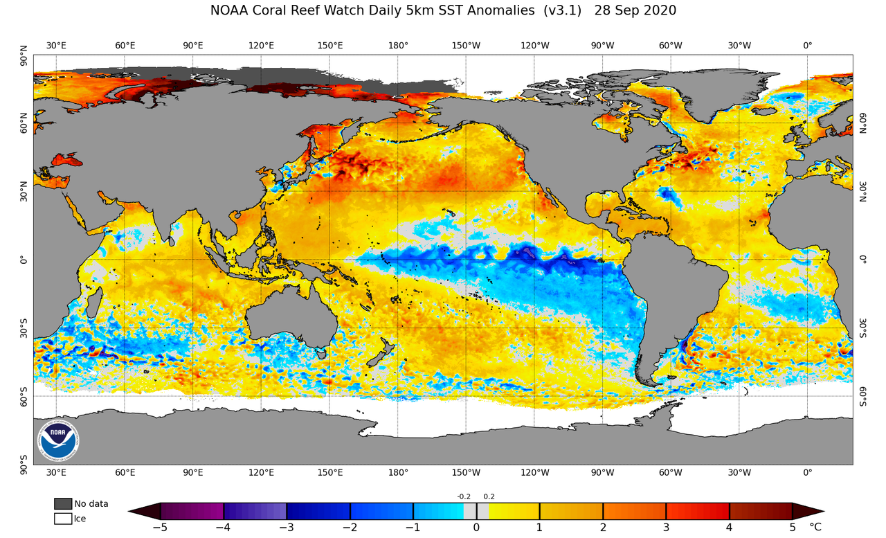
Re: 2021 Indicators: SST's / SAL / MSLP / Shear / Steering / Instability / Sat Images
A couple of important things to note from this map:
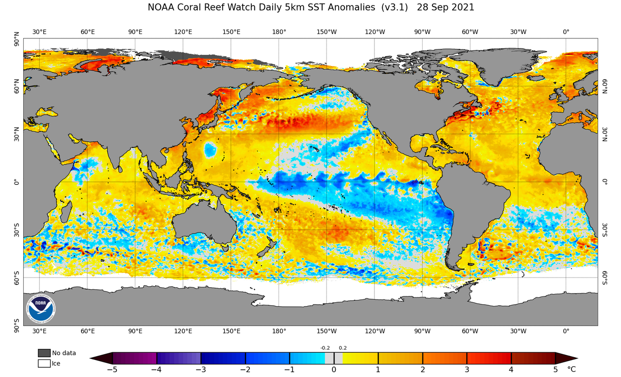
However, there are some more things to note:
TL;DR: The Pacific is cold, and the Atlantic is warm.
- There is a quite potent -PDO signal
- There is a strong -ENSO signal, which is on the verge of La Nina
- There is a very strong +TNA signal
- There is a very strong +AMO signal
- There is a noticeable -IOD signal
However, there are some more things to note:
- There are basically no -SSTAs in the Gulf of Mexico or the Caribbean; the cold wakes are gone
- There are very high +SSTAs in the Caribbean and the eastern MDR
- There is still a potent Atlantic Nino, which might have been the thing that helped 2021 achieve near record-breaking SSTs in the MDR
TL;DR: The Pacific is cold, and the Atlantic is warm.
1 likes
Re: 2021 Indicators: SST's / SAL / MSLP / Shear / Steering / Instability / Sat Images
CyclonicFury wrote:While the CFS was somewhat correct about the Caribbean wind shear for September being higher than normal, it massively overestimated wind shear in the MDR. I'm pretty sure it overestimated shear in August as well. It shows relatively high shear over the Caribbean in October, which is likely why it is bearish on activity, though I am very skeptical that will happen considering it is a La Niña year and CFS shear forecasts have not been very accurate.
Observed shear from September 1-27
https://i.imgur.com/8KT8sRp_d.webp?maxwidth=640&shape=thumb&fidelity=medium
CFS predicted shear (runs from August 25-28)
https://i.imgur.com/FwOcyVt.jpg
Considering the MJO as well as -ENSO climatology (with 18 of 22 -ENSO years since 1980 having a hurricane in the Caribbean or GoM during Oct/Nov), that would suggest an elevated risk of hurricane formation there, even if the first week of October doesn't look like it will have any development in that region.
The CFS and the observed shear appear use two different data sets regarding the average they compare to. 1968-96 average shear was likely significantly higher than either the 1991-2020 or 1981-2010 scale, so I'm not sure if these can really be directly compared. There Eastern Pacific south of Central America has also been warmer than normal, so the tropics are not necessarily behaving like a true La Nina on the Atlantic side.
0 likes
The above post is not official and should not be used as such. It is the opinion of the poster and may or may not be backed by sound meteorological data. It is not endorsed by any professional institution or storm2k.org. For official information, please refer to the NHC and NWS products.
-
AlphaToOmega
- Category 5
- Posts: 1448
- Joined: Sat Jun 26, 2021 10:51 am
- Location: Somewhere in Massachusetts
Re: 2021 Indicators: SST's / SAL / MSLP / Shear / Steering / Instability / Sat Images
Hammy wrote:CyclonicFury wrote:While the CFS was somewhat correct about the Caribbean wind shear for September being higher than normal, it massively overestimated wind shear in the MDR. I'm pretty sure it overestimated shear in August as well. It shows relatively high shear over the Caribbean in October, which is likely why it is bearish on activity, though I am very skeptical that will happen considering it is a La Niña year and CFS shear forecasts have not been very accurate.
Observed shear from September 1-27
https://i.imgur.com/8KT8sRp_d.webp?maxwidth=640&shape=thumb&fidelity=medium
CFS predicted shear (runs from August 25-28)
https://i.imgur.com/FwOcyVt.jpg
Considering the MJO as well as -ENSO climatology (with 18 of 22 -ENSO years since 1980 having a hurricane in the Caribbean or GoM during Oct/Nov), that would suggest an elevated risk of hurricane formation there, even if the first week of October doesn't look like it will have any development in that region.
The CFS and the observed shear appear use two different data sets regarding the average they compare to. 1968-96 average shear was likely significantly higher than either the 1991-2020 or 1981-2010 scale, so I'm not sure if these can really be directly compared. There Eastern Pacific south of Central America has also been warmer than normal, so the tropics are not necessarily behaving like a true La Nina on the Atlantic side.
2020 also featured a warm pool south of Central America this time of year.
Does anyone have a CFSv2 shear forecast for this date in 2020?
3 likes


Re: 2021 Indicators: SST's / SAL / MSLP / Shear / Steering / Instability / Sat Images
https://twitter.com/DerekOrtt/status/1443339383260815363
https://twitter.com/cyclonicwx/status/1443240131775942663
I've been reading through posts on this thread for the last few days and have also been looking at a lot of Twitter posts and honestly, I'm beginning to wonder if we should expect anything in October or November out of the Caribbean. Yes, the signs are there for it to be busy but that doesn't guarantee anything at the end of the day. Something Andy Hazelton brought up is that the ridge being so far north in Canada could allow troughs to sneak underneath and shear the Gulf of Mexico and Caribbean Sea out of business. Really not seeing that ridge over troubled waters look anyways, looks too far inland over Canada per the CFS. We'll see, will be cautious of course, but for now, I'm treating Sam and Victor as our last storms of the season, so a slider of each is always up on my computer cause it could be almost a year or more before we see activity like this in the MDR again
0 likes
-
ElectricStorm

- Category 5
- Posts: 4600
- Age: 23
- Joined: Tue Aug 13, 2019 11:23 pm
- Location: Skiatook, OK / Norman, OK
Re: 2021 Indicators: SST's / SAL / MSLP / Shear / Steering / Instability / Sat Images
WiscoWx02 wrote:https://twitter.com/DerekOrtt/status/1443339383260815363
https://twitter.com/cyclonicwx/status/1443240131775942663
I've been reading through posts on this thread for the last few days and have also been looking at a lot of Twitter posts and honestly, I'm beginning to wonder if we should expect anything in October or November out of the Caribbean. Yes, the signs are there for it to be busy but that doesn't guarantee anything at the end of the day. Something Andy Hazelton brought up is that the ridge being so far north in Canada could allow troughs to sneak underneath and shear the Gulf of Mexico and Caribbean Sea out of business. Really not seeing that ridge over troubled waters look anyways, looks too far inland over Canada per the CFS. We'll see, will be cautious of course, but for now, I'm treating Sam and Victor as our last storms of the season, so a slider of each is always up on my computer cause it could be almost a year or more before we see activity like this in the MDR again
I mean, even if there isn't much in the Caribbean or gulf there could still be something out in the subtropics like an Ophelia 2017 or Pablo 2019 type storm. I don't think anyone is expecting anything close to last year but that's not saying much considering 2020 was pretty much the only season to produce 5 majors in Oct/Nov.
3 likes
I am in no way a professional. Take what I say with a grain of salt as I could be totally wrong. Please refer to the NHC, NWS, or SPC for official information.
Boomer Sooner!
Boomer Sooner!
-
Category5Kaiju
- Category 5
- Posts: 3404
- Age: 22
- Joined: Thu Dec 24, 2020 12:45 pm
- Location: Seattle
Re: 2021 Indicators: SST's / SAL / MSLP / Shear / Steering / Instability / Sat Images
WiscoWx02 wrote:https://twitter.com/DerekOrtt/status/1443339383260815363
https://twitter.com/cyclonicwx/status/1443240131775942663
I've been reading through posts on this thread for the last few days and have also been looking at a lot of Twitter posts and honestly, I'm beginning to wonder if we should expect anything in October or November out of the Caribbean. Yes, the signs are there for it to be busy but that doesn't guarantee anything at the end of the day. Something Andy Hazelton brought up is that the ridge being so far north in Canada could allow troughs to sneak underneath and shear the Gulf of Mexico and Caribbean Sea out of business. Really not seeing that ridge over troubled waters look anyways, looks too far inland over Canada per the CFS. We'll see, will be cautious of course, but for now, I'm treating Sam and Victor as our last storms of the season, so a slider of each is always up on my computer cause it could be almost a year or more before we see activity like this in the MDR again
Eh, I personally believe the Atlantic will likely be fairly active in October once again; I am basing this on the general but telling idea that the EPAC is seriously beginning to wind down and that we are entering what looks to be a moderate La Nina phase, which is not necessarily favorable for high amounts of WPAC and EPAC activity. That's just me of course, but I simply find it hard to believe the Atlantic would just shut down after Victor given the -PDO, solidly -ENSO, -PMM phase as well as the VPs in October still looking good for the Atlantic. Now will there be two major hurricanes in November, each of them a high end Cat 4? Probably not, but the late season activity we saw last year should not be seen as a baseline, normal occurrence.
5 likes
Unless explicitly stated, all information covered in my posts is based on my opinions and observations. Please refer to a professional meteorologist or an accredited weather research agency otherwise, especially if serious decisions must be made in the event of a potentially life-threatening tropical storm or hurricane.
-
CyclonicFury
- Category 5
- Posts: 1975
- Age: 25
- Joined: Sun Jul 02, 2017 12:32 pm
- Location: NC
- Contact:
Re: 2021 Indicators: SST's / SAL / MSLP / Shear / Steering / Instability / Sat Images
October 2020 actually had its strongest -VP200 anomalies over the NIO and the Maritime Continent, not the Atlantic and Africa.

CFS seems to focus the strongest -VP200 anomalies around the same area as 2020, yet shows much stronger shear and a much less favorable environment than last year.

CFS seems to focus the strongest -VP200 anomalies around the same area as 2020, yet shows much stronger shear and a much less favorable environment than last year.
1 likes
NCSU B.S. in Meteorology Class of 2021. Tropical weather blogger at http://www.cyclonicfury.com. My forecasts and thoughts are NOT official, for official forecasts please consult the National Hurricane Center.
-
Category5Kaiju
- Category 5
- Posts: 3404
- Age: 22
- Joined: Thu Dec 24, 2020 12:45 pm
- Location: Seattle
Re: 2021 Indicators: SST's / SAL / MSLP / Shear / Steering / Instability / Sat Images
CyclonicFury wrote:October 2020 actually had its strongest -VP200 anomalies over the NIO and the Maritime Continent, not the Atlantic and Africa.
https://i.imgur.com/1ix4XA0.png
CFS seems to focus the strongest -VP200 anomalies around the same area as 2020, yet shows much stronger shear and a much less favorable environment than last year.
https://i.imgur.com/bG0lfNr.png
Hmm, well maybe the bigger question to ask is why exactly does the CFS think that the conditions this October won't be as favorable given what it is showing VP wise?
0 likes
Unless explicitly stated, all information covered in my posts is based on my opinions and observations. Please refer to a professional meteorologist or an accredited weather research agency otherwise, especially if serious decisions must be made in the event of a potentially life-threatening tropical storm or hurricane.
Re: 2021 Indicators: SST's / SAL / MSLP / Shear / Steering / Instability / Sat Images
Weather Dude wrote:WiscoWx02 wrote:https://twitter.com/DerekOrtt/status/1443339383260815363
https://twitter.com/cyclonicwx/status/1443240131775942663
I've been reading through posts on this thread for the last few days and have also been looking at a lot of Twitter posts and honestly, I'm beginning to wonder if we should expect anything in October or November out of the Caribbean. Yes, the signs are there for it to be busy but that doesn't guarantee anything at the end of the day. Something Andy Hazelton brought up is that the ridge being so far north in Canada could allow troughs to sneak underneath and shear the Gulf of Mexico and Caribbean Sea out of business. Really not seeing that ridge over troubled waters look anyways, looks too far inland over Canada per the CFS. We'll see, will be cautious of course, but for now, I'm treating Sam and Victor as our last storms of the season, so a slider of each is always up on my computer cause it could be almost a year or more before we see activity like this in the MDR again
I mean, even if there isn't much in the Caribbean or gulf there could still be something out in the subtropics like an Ophelia 2017 or Pablo 2019 type storm. I don't think anyone is expecting anything close to last year but that's not saying much considering 2020 was pretty much the only season to produce 5 majors in Oct/Nov.
Category5Kaiju wrote:WiscoWx02 wrote:https://twitter.com/DerekOrtt/status/1443339383260815363
https://twitter.com/cyclonicwx/status/1443240131775942663
I've been reading through posts on this thread for the last few days and have also been looking at a lot of Twitter posts and honestly, I'm beginning to wonder if we should expect anything in October or November out of the Caribbean. Yes, the signs are there for it to be busy but that doesn't guarantee anything at the end of the day. Something Andy Hazelton brought up is that the ridge being so far north in Canada could allow troughs to sneak underneath and shear the Gulf of Mexico and Caribbean Sea out of business. Really not seeing that ridge over troubled waters look anyways, looks too far inland over Canada per the CFS. We'll see, will be cautious of course, but for now, I'm treating Sam and Victor as our last storms of the season, so a slider of each is always up on my computer cause it could be almost a year or more before we see activity like this in the MDR again
Eh, I personally believe the Atlantic will likely be fairly active in October once again; I am basing this on the general but telling idea that the EPAC is seriously beginning to wind down and that we are entering what looks to be a moderate La Nina phase, which is not necessarily favorable for high amounts of WPAC and EPAC activity. That's just me of course, but I simply find it hard to believe the Atlantic would just shut down after Victor given the -PDO, solidly -ENSO, -PMM phase as well as the VPs in October still looking good for the Atlantic. Now will there be two major hurricanes in November, each of them a high end Cat 4? Probably not, but the late season activity we saw last year should not be seen as a baseline, normal occurrence.
Yeah 2020 October activity will never happen again probably. That was the definition of ridiculous and insanity. It's been almost a year and I'm still not over it.
Last edited by WiscoWx02 on Wed Sep 29, 2021 9:20 pm, edited 1 time in total.
3 likes
Who is online
Users browsing this forum: Emmett_Brown, FireRat, Google Adsense [Bot], Stratton23, zzzh and 51 guests