
Possible weak development east of FL this week? (Is 92L)
Moderator: S2k Moderators
Forum rules

The posts in this forum are NOT official forecasts and should not be used as such. They are just the opinion of the poster and may or may not be backed by sound meteorological data. They are NOT endorsed by any professional institution or STORM2K. For official information, please refer to products from the National Hurricane Center and National Weather Service.
-
tropicwatch

- Category 5

- Posts: 3205
- Age: 60
- Joined: Sat Jun 02, 2007 10:01 am
- Location: Panama City Florida
- Contact:
Re: Possible weak development east of FL this week?
A little increase in vorticity this morning with this system.

0 likes
Tropicwatch
Agnes 72', Eloise 75, Elena 85', Kate 85', Charley 86', Florence 88', Beryl 94', Dean 95', Erin 95', Opal 95', Earl 98', Georges 98', Ivan 2004', Arlene 2005', Dennis 2005', Ida 2009' Debby 2012' Irma 2017' Michael 2018'
Agnes 72', Eloise 75, Elena 85', Kate 85', Charley 86', Florence 88', Beryl 94', Dean 95', Erin 95', Opal 95', Earl 98', Georges 98', Ivan 2004', Arlene 2005', Dennis 2005', Ida 2009' Debby 2012' Irma 2017' Michael 2018'
-
tropicwatch
- Category 5
- Posts: 3205
- Age: 60
- Joined: Sat Jun 02, 2007 10:01 am
- Location: Panama City Florida
- Contact:
Re: Possible weak development east of FL this week?
Looking pretty good this morning.Visible Loop
0 likes
Tropicwatch
Agnes 72', Eloise 75, Elena 85', Kate 85', Charley 86', Florence 88', Beryl 94', Dean 95', Erin 95', Opal 95', Earl 98', Georges 98', Ivan 2004', Arlene 2005', Dennis 2005', Ida 2009' Debby 2012' Irma 2017' Michael 2018'
Agnes 72', Eloise 75, Elena 85', Kate 85', Charley 86', Florence 88', Beryl 94', Dean 95', Erin 95', Opal 95', Earl 98', Georges 98', Ivan 2004', Arlene 2005', Dennis 2005', Ida 2009' Debby 2012' Irma 2017' Michael 2018'


Re: Possible weak development east of FL this week?
NHC probably knows better than to call it too early this season.
0 likes
-
SouthDadeFish

- Professional-Met

- Posts: 2835
- Joined: Thu Sep 23, 2010 2:54 pm
- Location: Miami, FL
- Contact:
Climatologically speaking, the area just east of ULLs are typically the favorable location for cyclogenesis. The reason for this is that the ULL provides forcing for rising motion via advection of cyclonic vorticity by the thermal wind. Furthermore, this location also coincides with upper-level divergence. Wind shear is low (~10 knots) currently and 850 mb vorticity has been gradually increasing. It is something to keep an eye on. I think the key for any possibility of development with this system is if it can continue to fire sustained, deep convection.
0 likes
-
tropicwatch
- Category 5
- Posts: 3205
- Age: 60
- Joined: Sat Jun 02, 2007 10:01 am
- Location: Panama City Florida
- Contact:
Re:
"It is something to keep an eye on. I think the key for any possibility of development with this system is if it can continue to fire sustained, deep convection.
That has been the problem with a lot of systems this year.
0 likes
Tropicwatch
Agnes 72', Eloise 75, Elena 85', Kate 85', Charley 86', Florence 88', Beryl 94', Dean 95', Erin 95', Opal 95', Earl 98', Georges 98', Ivan 2004', Arlene 2005', Dennis 2005', Ida 2009' Debby 2012' Irma 2017' Michael 2018'
Agnes 72', Eloise 75, Elena 85', Kate 85', Charley 86', Florence 88', Beryl 94', Dean 95', Erin 95', Opal 95', Earl 98', Georges 98', Ivan 2004', Arlene 2005', Dennis 2005', Ida 2009' Debby 2012' Irma 2017' Michael 2018'
-
SouthDadeFish
- Professional-Met
- Posts: 2835
- Joined: Thu Sep 23, 2010 2:54 pm
- Location: Miami, FL
- Contact:
-
SFLcane

- S2K Supporter

- Posts: 9621
- Age: 46
- Joined: Sat Jun 05, 2010 1:44 pm
- Location: Lake Worth Florida
Re: Possible weak development east of FL this week?
Yep slight possibility for development. Watch loop outflow boundaries not what you would expect with developing TC. This is still upper level system
http://climate.cod.edu/janis/satellite/ ... mas-vis-12
http://climate.cod.edu/janis/satellite/ ... mas-vis-12
0 likes
Re: Possible weak development east of FL this week?
SFLcane wrote:Yep slight possibility for development. Watch loop outflow boundaries not what you would expect with developing TC. This is still upper level system
http://climate.cod.edu/janis/satellite/ ... mas-vis-12
No question that this is still being influenced to form convection by the mid and upper level low like SouthDadeFish mentioned, so no surprise that there is an outflow boundary visible on satellite, if convection keeps developing it could eventually form a surface reflection as the ULL pushes away from it.
0 likes
-
SFLcane
- S2K Supporter
- Posts: 9621
- Age: 46
- Joined: Sat Jun 05, 2010 1:44 pm
- Location: Lake Worth Florida
Re: Possible weak development east of FL this week?
Nearing peak and plenty of warm sst's near South Florida so it's worth a watch.
0 likes
-
wxman57

- Moderator-Pro Met

- Posts: 22495
- Age: 66
- Joined: Sat Jun 21, 2003 8:06 pm
- Location: Houston, TX (southwest)
Re:
SouthDadeFish wrote:Surface pressures still seem to be high throughout the Turks and Caicos.
Yeah, I was going to point that out. Pressures are in the 1018mb-1020mb range throughout the Bahamas. It's an upper-level feature. Euro moves it westward across Florida over the next couple of days then into the north-central Gulf by this weekend, merging it with an approaching cold front.
0 likes
-
SFLcane
- S2K Supporter
- Posts: 9621
- Age: 46
- Joined: Sat Jun 05, 2010 1:44 pm
- Location: Lake Worth Florida
Re: Possible weak development east of FL this week?
Yea..... More rain for us not that we have not had enough this summer.
0 likes
-
floridasun78
- Category 5
- Posts: 3755
- Joined: Sun May 17, 2009 10:16 pm
- Location: miami fl
Re: Possible weak development east of FL this week?
so wx saying move on their not thing watch here
0 likes
Re: Re:
wxman57 wrote:SouthDadeFish wrote:Surface pressures still seem to be high throughout the Turks and Caicos.
Yeah, I was going to point that out. Pressures are in the 1018mb-1020mb range throughout the Bahamas. It's an upper-level feature. Euro moves it westward across Florida over the next couple of days then into the north-central Gulf by this weekend, merging it with an approaching cold front.
The ULL is now a good distance away from the area of convection with a nice h70 & h85 over the area by the convection. Surface pressures in this area have been high in this area to begin with. Many times have we seen tropical development in an environment of relatively high surface pressures.
0 likes
-
tropicwatch
- Category 5
- Posts: 3205
- Age: 60
- Joined: Sat Jun 02, 2007 10:01 am
- Location: Panama City Florida
- Contact:
Re: Possible weak development east of FL this week?
0 likes
Tropicwatch
Agnes 72', Eloise 75, Elena 85', Kate 85', Charley 86', Florence 88', Beryl 94', Dean 95', Erin 95', Opal 95', Earl 98', Georges 98', Ivan 2004', Arlene 2005', Dennis 2005', Ida 2009' Debby 2012' Irma 2017' Michael 2018'
Agnes 72', Eloise 75, Elena 85', Kate 85', Charley 86', Florence 88', Beryl 94', Dean 95', Erin 95', Opal 95', Earl 98', Georges 98', Ivan 2004', Arlene 2005', Dennis 2005', Ida 2009' Debby 2012' Irma 2017' Michael 2018'
-
wxman57
- Moderator-Pro Met
- Posts: 22495
- Age: 66
- Joined: Sat Jun 21, 2003 8:06 pm
- Location: Houston, TX (southwest)
Re: Possible weak development east of FL this week?
floridasun78 wrote:so wx saying move on their not thing watch here
Not in precisely those words, however.
0 likes
After carefully examining the GFS/Euro, I think this could be a sleeper. (This feeling has very little to do with the NAM, a poor model to determine chances for genesis.) The Euro/GFS at least suggest to me a pretty good chance for at least a weak surface low to form within the next couple of days near the Bahamas. Also, progged upper level steering/conditions are not at all looking inhospitable to me. Per the Euro, upper level high pressure would dominate near and to the north of this near and offshore the SE US/Gulf coast through the weekend (i.e., before the unfavorable long wave trough enters). Looking more closely, the winds don't look all that unfavorable all of the way up to 200 mb into much of the weekend in much of the area. When I see a potential surface low off the SE coast forming near the bottom of an upper level high that looks to persist for at least a few days, it normally at least gets my attention. In summary, I think this currently has a nontrivial chance to develop into a TC within the next couple of days east of FL and, if so, quite possibly subsequently threaten parts of the SE US/Gulf coast since there'd probably be no recurve into the weekend and upper levels would seemingly be favorable for development.
0 likes
Personal Forecast Disclaimer:
The posts in this forum are NOT official forecasts and should not be used as such. They are just the opinion of the poster and may or may not be backed by sound meteorological data. They are NOT endorsed by any professional institution or storm2k.org. For official information, please refer to the NHC and NWS products.
The posts in this forum are NOT official forecasts and should not be used as such. They are just the opinion of the poster and may or may not be backed by sound meteorological data. They are NOT endorsed by any professional institution or storm2k.org. For official information, please refer to the NHC and NWS products.
-
tropicwatch
- Category 5
- Posts: 3205
- Age: 60
- Joined: Sat Jun 02, 2007 10:01 am
- Location: Panama City Florida
- Contact:
Re: Possible weak development east of FL this week?
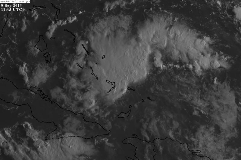
panamatropicwatch wrote:Pro-Mets can you explain the feature southeast of the convection expanding outward?
Visible Loop
Anyone?
0 likes
Tropicwatch
Agnes 72', Eloise 75, Elena 85', Kate 85', Charley 86', Florence 88', Beryl 94', Dean 95', Erin 95', Opal 95', Earl 98', Georges 98', Ivan 2004', Arlene 2005', Dennis 2005', Ida 2009' Debby 2012' Irma 2017' Michael 2018'
Agnes 72', Eloise 75, Elena 85', Kate 85', Charley 86', Florence 88', Beryl 94', Dean 95', Erin 95', Opal 95', Earl 98', Georges 98', Ivan 2004', Arlene 2005', Dennis 2005', Ida 2009' Debby 2012' Irma 2017' Michael 2018'
-
wxman57
- Moderator-Pro Met
- Posts: 22495
- Age: 66
- Joined: Sat Jun 21, 2003 8:06 pm
- Location: Houston, TX (southwest)
Re: Possible weak development east of FL this week?
panamatropicwatch wrote:panamatropicwatch wrote:Pro-Mets can you explain the feature southeast of the convection expanding outward?
Visible Loop
Anyone?
What you're observing in that loop is an outlfow boundary. When a thunderstorm collapses, it pushes out a rush of air near the surface. This rush of air can often be seen as a ring of low clouds propagating radially outward from the collapsed thunderstorm.
0 likes