2015 indicators: Instability / SST's / MSLP / Steering / Sal

This is the general tropical discussion area. Anyone can take their shot at predicting a storms path.

Moderator: S2k Moderators

Forum rules

The posts in this forum are NOT official forecasts and should not be used as such. They are just the opinion of the poster and may or may not be backed by sound meteorological data. They are NOT endorsed by any professional institution or STORM2K. For official information, please refer to products from the National Hurricane Center and National Weather Service.

Help Support Storm2K
Message
Author
Ntxw
Storm2k Moderator
Storm2k Moderator
Posts: 21523
Joined: Wed Oct 21, 2009 6:34 pm
Location: DFW, Texas

Re:

#601 Postby Ntxw » Fri Oct 02, 2015 8:30 pm

Hammy wrote:Joaquin, along with the strength of the waves during Aug/Sep, makes me wonder what this year would've been without El Nino.


One thing is for sure, dry air is a thing of the past. Not just around the Atlantic, the globe as a whole. The El Nino has definitely pumped lots of moisture into the global atmosphere I'd think, something I was wondering a few years ago needing a shake up in ENSO.
0 likes   
The above post and any post by Ntxw is NOT an official forecast and should not be used as such. It is just the opinion of the poster and may or may not be backed by sound meteorological data. It is NOT endorsed by any professional institution including Storm2k. For official information, please refer to NWS products.

  Help support Storm2K!
Help Support Storm2K

User avatar
JtSmarts
S2K Supporter
S2K Supporter
Posts: 1422
Age: 38
Joined: Thu Jul 10, 2003 1:29 pm
Location: Columbia, South Carolina

Re:

#602 Postby JtSmarts » Fri Oct 02, 2015 10:09 pm

Hammy wrote:Joaquin, along with the strength of the waves during Aug/Sep, makes me wonder what this year would've been without El Nino.


Someone said it would have been like a redux of 2004 and I agree. 2016 might be a season for the ages.
0 likes   

User avatar
Yellow Evan
Professional-Met
Professional-Met
Posts: 15956
Age: 25
Joined: Fri Jul 15, 2011 12:48 pm
Location: Henderson, Nevada/Honolulu, HI
Contact:

Re: Re:

#603 Postby Yellow Evan » Fri Oct 02, 2015 10:16 pm

JtSmarts wrote:
Hammy wrote:Joaquin, along with the strength of the waves during Aug/Sep, makes me wonder what this year would've been without El Nino.


Someone said it would have been like a redux of 2004 and I agree. 2016 might be a season for the ages.


Not if the -AMO continues.
0 likes   

User avatar
NDG
S2K Supporter
S2K Supporter
Posts: 14933
Joined: Sun Jul 09, 2006 10:14 pm
Location: Orlando, FL

Re: 2015 indicators: Instability / SST's / MSLP / Steering / Sal

#604 Postby NDG » Sat Oct 03, 2015 4:51 am

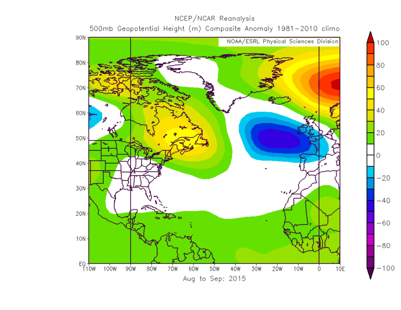
:uarrow: The -NAO at least during the last couple of months was based in the eastern Atlantic, it makes a big difference. This pattern was very similar to 2004 (the ridging in SE Canada and the weakness all the way in the NE Atlantic). If we get the same pattern next year we would be in trouble, but of course many things can change.

Image
0 likes   

User avatar
Ptarmigan
Category 5
Category 5
Posts: 5273
Joined: Wed Aug 16, 2006 9:06 pm

Re: Re:

#605 Postby Ptarmigan » Sat Oct 03, 2015 10:50 am

Ntxw wrote:
Hammy wrote:Joaquin, along with the strength of the waves during Aug/Sep, makes me wonder what this year would've been without El Nino.


One thing is for sure, dry air is a thing of the past. Not just around the Atlantic, the globe as a whole. The El Nino has definitely pumped lots of moisture into the global atmosphere I'd think, something I was wondering a few years ago needing a shake up in ENSO.


One thing I notice is that seasons following El Nino tend to be active like 1988, 1995, 1998, 2005, and 2010.
0 likes   

User avatar
WPBWeather
S2K Supporter
S2K Supporter
Posts: 535
Age: 65
Joined: Thu Jul 18, 2013 12:33 pm

Re: 2015 indicators: Instability / SST's / MSLP / Steering / Sal

#606 Postby WPBWeather » Sat Oct 03, 2015 12:09 pm

Early indications of 2016 are not good--see long range climate models--so I hope it does not verify.

However, Joaquin and other storms should point out to people who have lack of activity issues with the MDR and the ATL should take pause.
0 likes   

Ntxw
Storm2k Moderator
Storm2k Moderator
Posts: 21523
Joined: Wed Oct 21, 2009 6:34 pm
Location: DFW, Texas

#607 Postby Ntxw » Sat Oct 03, 2015 12:16 pm

Joaquin has added 17.225 units of ACE to the seasonal total to bring it up to 46.2725 to date. This single storm makes up about 60% of the season, very impressive hurricane. This ranks 2015 in between 1973 (43 units) and 2009 (53 units)
0 likes   
The above post and any post by Ntxw is NOT an official forecast and should not be used as such. It is just the opinion of the poster and may or may not be backed by sound meteorological data. It is NOT endorsed by any professional institution including Storm2k. For official information, please refer to NWS products.


  Help support Storm2K!

Help Support Storm2K


WeatherEmperor
S2K Supporter
S2K Supporter
Posts: 4806
Age: 40
Joined: Thu Sep 04, 2003 2:54 pm
Location: South Florida

2015 indicators: Instability / SST's / MSLP / Steering / Sal

#608 Postby WeatherEmperor » Sat Oct 03, 2015 12:29 pm

WPBWeather wrote:Early indications of 2016 are not good--see long range climate models--so I hope it does not verify.

However, Joaquin and other storms should point out to people who have lack of activity issues with the MDR and the ATL should take pause.


Can you elaborate on 2016? Are you saying next year will be more active?


Sent from my iPhone6 using Tapatalk
0 likes   

User avatar
WPBWeather
S2K Supporter
S2K Supporter
Posts: 535
Age: 65
Joined: Thu Jul 18, 2013 12:33 pm

Re: 2015 indicators: Instability / SST's / MSLP / Steering / Sal

#609 Postby WPBWeather » Sat Oct 03, 2015 11:22 pm

WeatherEmperor wrote:
WPBWeather wrote:Early indications of 2016 are not good--see long range climate models--so I hope it does not verify.

However, Joaquin and other storms should point out to people who have lack of activity issues with the MDR and the ATL should take pause.


Can you elaborate on 2016? Are you saying next year will be more active?


Sent from my iPhone6 using Tapatalk


I'll post a link to the CFS V2 sites later. They predict a bad 2016, if they are to be believed.

All this has been noted by J Bastardi on WeatherBell and Eric Blake and Michael Ventrice on Twitter already.
0 likes   

User avatar
Hurricaneman
Category 5
Category 5
Posts: 7284
Age: 43
Joined: Tue Aug 31, 2004 3:24 pm
Location: central florida

Re: 2015 indicators: Instability / SST's / MSLP / Steering / Sal

#610 Postby Hurricaneman » Sun Oct 04, 2015 12:08 am

WPBWeather wrote:
WeatherEmperor wrote:
WPBWeather wrote:Early indications of 2016 are not good--see long range climate models--so I hope it does not verify.

However, Joaquin and other storms should point out to people who have lack of activity issues with the MDR and the ATL should take pause.


Can you elaborate on 2016? Are you saying next year will be more active?


Sent from my iPhone6 using Tapatalk


I'll post a link to the CFS V2 sites later. They predict a bad 2016, if they are to be believed.

All this has been noted by J Bastardi on WeatherBell and Eric Blake and Michael Ventrice on Twitter already.


Thats what I'm expecting a high impact year in 2016 but I'll give more details in December when I give a general first forecast for 2016 and in addition will start the 2016 version of this thread at that point

The posts in this forum are NOT official forecast and should not be used as such. They are just the opinion of the poster and may or may not be backed by sound meteorological data. They are NOT endorsed by any professional institution or storm2k.org. For official information, please refer to the NHC and NWS products
0 likes   

User avatar
WPBWeather
S2K Supporter
S2K Supporter
Posts: 535
Age: 65
Joined: Thu Jul 18, 2013 12:33 pm

Re: 2015 indicators: Instability / SST's / MSLP / Steering / Sal

#611 Postby WPBWeather » Sun Oct 04, 2015 12:38 pm

I'll look forward to your future posts then HM. Hope it's not too high impact in 2016 though. :cry:
0 likes   

User avatar
gatorcane
S2K Supporter
S2K Supporter
Posts: 23499
Age: 46
Joined: Sun Mar 13, 2005 3:54 pm
Location: Boca Raton, FL

#612 Postby gatorcane » Sun Oct 04, 2015 2:59 pm

The SW Caribbean looks like an area to watch towards the mid October-time frame. We can see the wet phase of the MJO looks to be moving over the region though the core is over the EPAC. The GFS and ensembles seem to be latching on to something possibly forming there starting in the the 10-12 day timeframe. Climatology, this area is favored as we move through October:

Image
0 likes   

User avatar
Yellow Evan
Professional-Met
Professional-Met
Posts: 15956
Age: 25
Joined: Fri Jul 15, 2011 12:48 pm
Location: Henderson, Nevada/Honolulu, HI
Contact:

#613 Postby Yellow Evan » Sun Oct 04, 2015 3:08 pm

MJO has been in dead circle since July. However, from time to time, a CCKW will pass through the region.

With all the shear in the Caribbean, good luck getting a TC there.
0 likes   

User avatar
NDG
S2K Supporter
S2K Supporter
Posts: 14933
Joined: Sun Jul 09, 2006 10:14 pm
Location: Orlando, FL

#614 Postby NDG » Sun Oct 04, 2015 5:27 pm

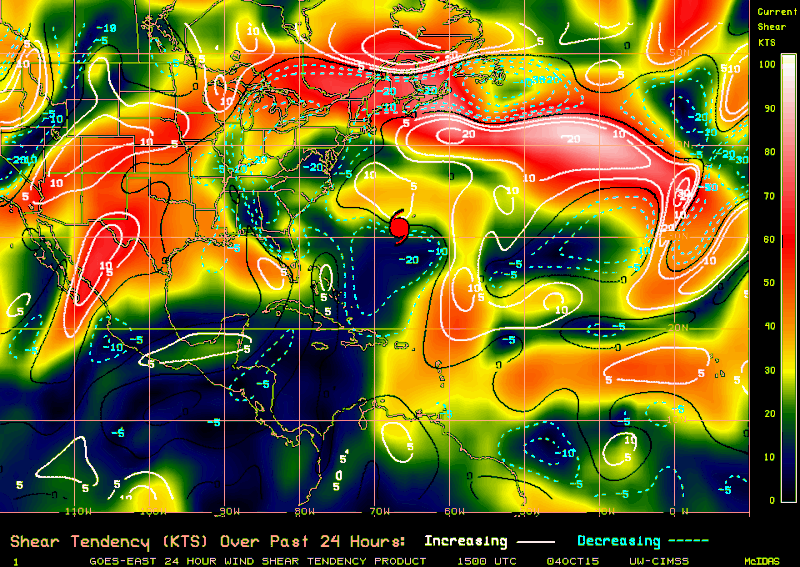
:uarrow: Shear has really led up some over the Caribbean lately, as the subtropical jet gets going over the next few weeks over the southern US it means that conditions may stay conducive over the Caribbean.

Image
0 likes   

User avatar
WPBWeather
S2K Supporter
S2K Supporter
Posts: 535
Age: 65
Joined: Thu Jul 18, 2013 12:33 pm

Re: 2015 indicators: Instability / SST's / MSLP / Steering / Sal

#615 Postby WPBWeather » Sun Oct 04, 2015 6:14 pm

NDG: Are you trying to confuse us with actual evidence and not unsupported statements?? Naughty! :D
0 likes   

User avatar
Hammy
Category 5
Category 5
Posts: 5594
Age: 40
Joined: Fri May 25, 2012 5:25 pm
Contact:

#616 Postby Hammy » Sun Oct 04, 2015 8:12 pm

I don't think I've seen shear that low in the NW Caribbean for quite some time.
0 likes   
The above post is not official and should not be used as such. It is the opinion of the poster and may or may not be backed by sound meteorological data. It is not endorsed by any professional institution or storm2k.org. For official information, please refer to the NHC and NWS products.

User avatar
gatorcane
S2K Supporter
S2K Supporter
Posts: 23499
Age: 46
Joined: Sun Mar 13, 2005 3:54 pm
Location: Boca Raton, FL

Re:

#617 Postby gatorcane » Sun Oct 04, 2015 8:33 pm

Hammy wrote:I don't think I've seen shear that low in the NW Caribbean for quite some time.

Agreed this is the most favorable I have seen the Western and NW Caribbean all season and just in time for October where this region is climatologically-favored. The question is what will the shear look like in around 10-14 days as that is when GFS is starting to show something developing in this area:

Image
0 likes   

User avatar
Hurricaneman
Category 5
Category 5
Posts: 7284
Age: 43
Joined: Tue Aug 31, 2004 3:24 pm
Location: central florida

#618 Postby Hurricaneman » Mon Oct 05, 2015 12:00 am

The SW Caribbean is the place to watch the next few weeks as there seems to be a period of low shear there possible

The posts in this forum are NOT official forecast and should not be used as such. They are just the opinion of the poster and may or may not be backed by sound meteorological data. They are NOT endorsed by any professional institution or storm2k.org. For official information, please refer to the NHC and NWS products
0 likes   

LarryWx
Category 5
Category 5
Posts: 5739
Joined: Sun Sep 07, 2003 2:04 pm
Location: GA

#619 Postby LarryWx » Mon Oct 05, 2015 12:52 am

:uarrow: HM,
Agreed. The 0Z GFS fwiw does suggest low shear in mid Oct.

Also, let's look at some 1851-2009 based climo here: http://www.nhc.noaa.gov/climo/#ori10

Counting the dots on each panel for each 10 (11) day period for these 159 years, the five busiest for genesis in the Caribbean west of 77.5 W are as follows:

10/11-20: 35
10/1-10: 32
9/21-30: 18
6/11-20: 12
10/21-31: 12

So, one can see how much more active for genesis is 10/1-20 than any other period in the W Caribbean. For 2015 per the GFS, we're keying in on 10/11-20. 35 geneses over 159 years (with some likely missed before the satellite era) is a lot for such a small area over just a ten day period. As HM, Gator, and many others know, that's why especially FL, Caymans, Jamaica, and Cuba have to watch this area of the basin so carefully early to mid Oct.

Edit: Out of the 35 W. Caribbean 10/11-20 geneses, a worrisome 13 hit S or C FL as a H with the hit dates centered on 10/20:

1865, 1870, 1876, 1878, 1904, 1921, 1924, 1926, 1944, 1950, 1968, 1999, 2005 or one every 12 years

Note, however, that although 3 of these 13 were during El Niño (1876, 1904, 1968), they were during weak first year ones fwiw.
Last edited by LarryWx on Thu Oct 08, 2015 1:31 pm, edited 1 time in total.
0 likes   
Personal Forecast Disclaimer:
The posts in this forum are NOT official forecasts and should not be used as such. They are just the opinion of the poster and may or may not be backed by sound meteorological data. They are NOT endorsed by any professional institution or storm2k.org. For official information, please refer to the NHC and NWS products.

User avatar
Hurricaneman
Category 5
Category 5
Posts: 7284
Age: 43
Joined: Tue Aug 31, 2004 3:24 pm
Location: central florida

#620 Postby Hurricaneman » Mon Oct 05, 2015 8:46 am

I'm actually quite surprised at how well this season has done in spite of a Super Nino, Didnt think that the MDR in any way, shape or form would be active

The posts in this forum are NOT official forecast and should not be used as such. They are just the opinion of the poster and may or may not be backed by sound meteorological data. They are NOT endorsed by any professional institution or storm2k.org. For official information, please refer to the NHC and NWS products
0 likes   


Return to “Talkin' Tropics”

Who is online

Users browsing this forum: Google Adsense [Bot], kevin, Lizzytiz1, MEANINGLESS_NUMBERS and 31 guests