2018 Indicators: SST's / MSLP / Sal / Steering / Shear / Instability (Graphic updates at first post)

This is the general tropical discussion area. Anyone can take their shot at predicting a storms path.

Moderator: S2k Moderators

Forum rules

The posts in this forum are NOT official forecasts and should not be used as such. They are just the opinion of the poster and may or may not be backed by sound meteorological data. They are NOT endorsed by any professional institution or STORM2K. For official information, please refer to products from the National Hurricane Center and National Weather Service.

Help Support Storm2K
Message
Author
User avatar
wxman57
Moderator-Pro Met
Moderator-Pro Met
Posts: 22484
Age: 66
Joined: Sat Jun 21, 2003 8:06 pm
Location: Houston, TX (southwest)

Re: 2018 Indicators: SST's / MSLP / Sal / Steering / Shear / Instability (Graphic updates at first post)

#721 Postby wxman57 » Fri Jul 27, 2018 3:30 pm

NDG wrote:See the difference? A good 1C difference in many spots.
https://i.imgur.com/drhz6Fn.gif
https://i.imgur.com/gkqxgSv.png


Hard to tell, but my initial estimate is that the temps are warmer on the CDAS map. Look at 20N/40W, for example. About 24.8C on OSITA and 25.5C on CDAS. At 10N/40W, I see 27C on OSITA (top map) and 25.5C on CDAS. Are we saying that the top map is warmer than CDAS?
1 likes   

User avatar
NDG
S2K Supporter
S2K Supporter
Posts: 14934
Joined: Sun Jul 09, 2006 10:14 pm
Location: Orlando, FL

Re: 2018 Indicators: SST's / MSLP / Sal / Steering / Shear / Instability (Graphic updates at first post)

#722 Postby NDG » Fri Jul 27, 2018 5:17 pm

wxman57 wrote:
NDG wrote:See the difference? A good 1C difference in many spots.
https://i.imgur.com/drhz6Fn.gif
https://i.imgur.com/gkqxgSv.png


Hard to tell, but my initial estimate is that the temps are warmer on the CDAS map. Look at 20N/40W, for example. About 24.8C on OSITA and 25.5C on CDAS. At 10N/40W, I see 27C on OSITA (top map) and 25.5C on CDAS. Are we saying that the top map is warmer than CDAS?


This is one of the areas, highlighted in red, that I have in question in which OSITA shows warmer SSTs than on CDAS, between 10N-20N & 40W-50W
It also shows the 27C SST isotherm further north than CDAS. Maybe not a whole 1C difference between the two in most areas but in most by a least a half degree C difference, IMO.


Image
Image
1 likes   

Ntxw
Storm2k Moderator
Storm2k Moderator
Posts: 21525
Joined: Wed Oct 21, 2009 6:34 pm
Location: DFW, Texas

Re: 2018 Indicators: SST's / MSLP / Sal / Steering / Shear / Instability (Graphic updates at first post)

#723 Postby Ntxw » Fri Jul 27, 2018 6:59 pm

So in essence it has been cooling? Perhaps not to what the CDAS was showing (oversensitive) but on OISST as well.

 https://twitter.com/RyanMaue/status/1022954634116300800


0 likes   
The above post and any post by Ntxw is NOT an official forecast and should not be used as such. It is just the opinion of the poster and may or may not be backed by sound meteorological data. It is NOT endorsed by any professional institution including Storm2k. For official information, please refer to NWS products.

  Help support Storm2K!
Help Support Storm2K

User avatar
Hammy
Category 5
Category 5
Posts: 5594
Age: 40
Joined: Fri May 25, 2012 5:25 pm
Contact:

Re: 2018 Indicators: SST's / MSLP / Sal / Steering / Shear / Instability (Graphic updates at first post)

#724 Postby Hammy » Fri Jul 27, 2018 9:09 pm

:uarrow: Not to say we're having another 2013 but questioning more as a potential indicator--is there something similar going on with the ocean circulation that could be causing this?
2 likes   
The above post is not official and should not be used as such. It is the opinion of the poster and may or may not be backed by sound meteorological data. It is not endorsed by any professional institution or storm2k.org. For official information, please refer to the NHC and NWS products.

User avatar
NotSparta
Professional-Met
Professional-Met
Posts: 1655
Age: 22
Joined: Fri Aug 18, 2017 8:24 am
Location: Naples, FL
Contact:

Re: 2018 Indicators: SST's / MSLP / Sal / Steering / Shear / Instability (Graphic updates at first post)

#725 Postby NotSparta » Fri Jul 27, 2018 9:43 pm

Hammy wrote::uarrow: Not to say we're having another 2013 but questioning more as a potential indicator--is there something similar going on with the ocean circulation that could be causing this?


No, it's mostly atmospheric stuff here like trades & SAL that are capping the SSTs. I feel like those are low-balling the SSTs there too since there are buoys that are reporting warmer.
3 likes   
This post was probably an opinion of mine, and in no way is official. Please refer to http://www.hurricanes.gov for official tropical analysis and advisories.

My website, with lots of tropical wx graphics, including satellite and recon: http://cyclonicwx.com

Ntxw
Storm2k Moderator
Storm2k Moderator
Posts: 21525
Joined: Wed Oct 21, 2009 6:34 pm
Location: DFW, Texas

Re: 2018 Indicators: SST's / MSLP / Sal / Steering / Shear / Instability (Graphic updates at first post)

#726 Postby Ntxw » Sat Jul 28, 2018 9:45 am

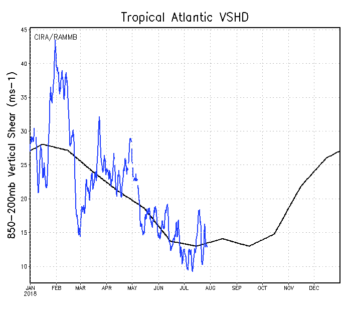
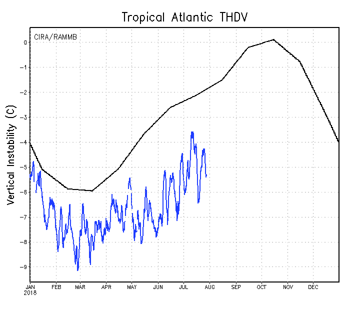
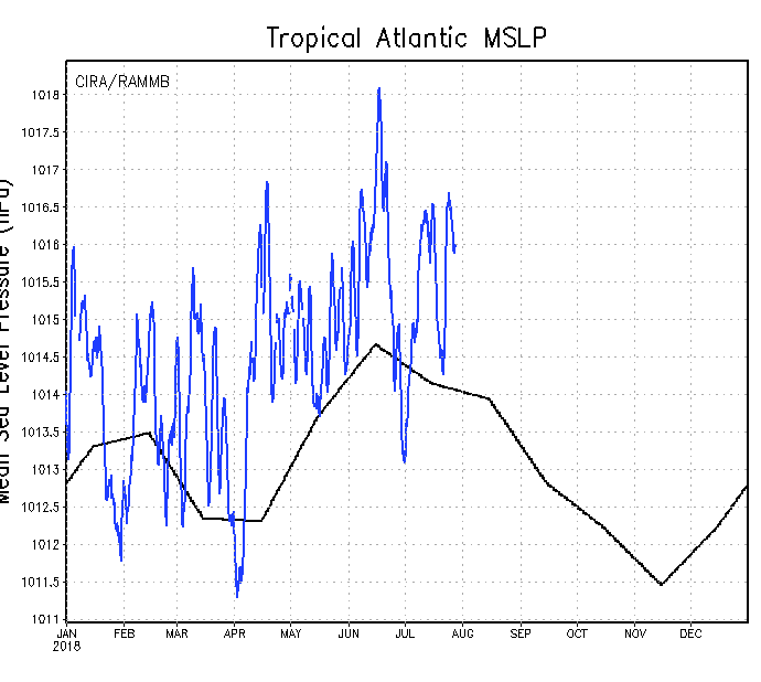
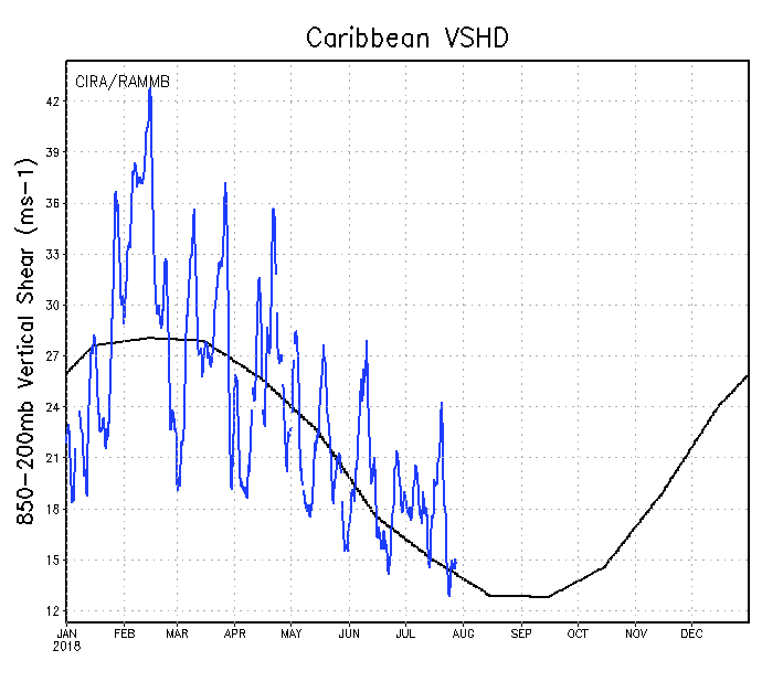
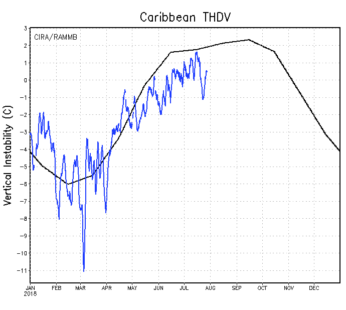
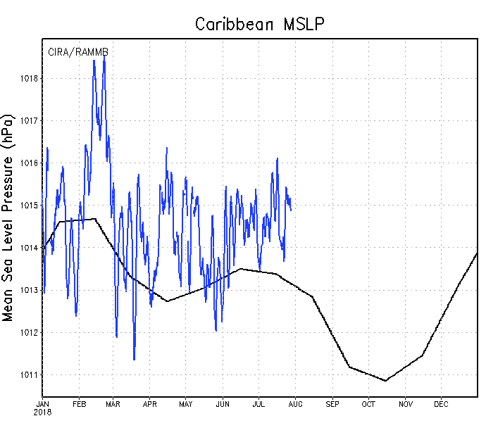
Some updated graphics from the rammb (CIRA CSU) for those following the metrics for the MDR

Tropical Atlantic

Shear

Image

Vertical Instability

Image

Pressure (MSLP)

Image


Caribbean

Shear

Image

Vertical Instability

Image

Pressure (MSLP)

Image
1 likes   
The above post and any post by Ntxw is NOT an official forecast and should not be used as such. It is just the opinion of the poster and may or may not be backed by sound meteorological data. It is NOT endorsed by any professional institution including Storm2k. For official information, please refer to NWS products.


  Help support Storm2K!

Help Support Storm2K


User avatar
Kingarabian
S2K Supporter
S2K Supporter
Posts: 15451
Joined: Sat Aug 08, 2009 3:06 am
Location: Honolulu, Hawaii

Re: 2018 Indicators: SST's / MSLP / Sal / Steering / Shear / Instability (Graphic updates at first post)

#727 Postby Kingarabian » Sat Jul 28, 2018 2:39 pm

3 likes   
RIP Kobe Bryant

floridasun78
Category 5
Category 5
Posts: 3755
Joined: Sun May 17, 2009 10:16 pm
Location: miami fl

Re: 2018 Indicators: SST's / MSLP / Sal / Steering / Shear / Instability (Graphic updates at first post)

#728 Postby floridasun78 » Sat Jul 28, 2018 10:34 pm

too me loook aug could slow because Africa duct and EL Niño trying make come back i see alot shear in tropical too specifically in Caribbean
0 likes   

User avatar
NDG
S2K Supporter
S2K Supporter
Posts: 14934
Joined: Sun Jul 09, 2006 10:14 pm
Location: Orlando, FL

Re: 2018 Indicators: SST's / MSLP / Sal / Steering / Shear / Instability (Graphic updates at first post)

#729 Postby NDG » Sun Jul 29, 2018 6:44 am

Kingarabian wrote:https://twitter.com/BenNollWeather/status/1023188777198530560


I hate when people bring up 2005 as a comparison, we all know that it was once in a 50 year event. But yet only one hurricane formed east of 60W over the Atlantic MDR that year despite all the very warm SSTs.
4 likes   

LarryWx
Category 5
Category 5
Posts: 5743
Joined: Sun Sep 07, 2003 2:04 pm
Location: GA

Re: 2018 Indicators: SST's / MSLP / Sal / Steering / Shear / Instability (Graphic updates at first post)

#730 Postby LarryWx » Sun Jul 29, 2018 8:12 am

Do you or does anyone else know of a link to these 2 MSLP anomaly graphs (as well as that for the GOM) for ASO of 2017? I’d like to see how low the MSLP actually was in relation to normal. I looked back in the “2017 Indicators” topic here and didn’t see them. Thanks in advance.
0 likes   
Personal Forecast Disclaimer:
The posts in this forum are NOT official forecasts and should not be used as such. They are just the opinion of the poster and may or may not be backed by sound meteorological data. They are NOT endorsed by any professional institution or storm2k.org. For official information, please refer to the NHC and NWS products.

User avatar
NDG
S2K Supporter
S2K Supporter
Posts: 14934
Joined: Sun Jul 09, 2006 10:14 pm
Location: Orlando, FL

Re: 2018 Indicators: SST's / MSLP / Sal / Steering / Shear / Instability (Graphic updates at first post)

#731 Postby NDG » Sun Jul 29, 2018 8:15 am

LarryWx wrote: Do you or does anyone else know of a link to these 2 MSLP anomaly graphs (as well as that for the GOM) for ASO of 2017? I’d like to see how low the MSLP actually was in relation to normal. I looked back in the “2017 Indicators” topic here and didn’t see them. Thanks in advance.


Unfortunately they don't have it for MSLPs

http://rammb.cira.colostate.edu/project ... index.html
0 likes   

User avatar
toad strangler
S2K Supporter
S2K Supporter
Posts: 4174
Joined: Sun Jul 28, 2013 3:09 pm
Location: Earth
Contact:

Re: 2018 Indicators: SST's / MSLP / Sal / Steering / Shear / Instability (Graphic updates at first post)

#732 Postby toad strangler » Sun Jul 29, 2018 9:08 am

NDG wrote:
Kingarabian wrote:https://twitter.com/BenNollWeather/status/1023188777198530560


I hate when people bring up 2005 as a comparison, we all know that it was once in a 50 year event. But yet only one hurricane formed east of 60W over the Atlantic MDR that year despite all the very warm SSTs.


Well SST's are quite warm close to home (USA & SW Caribbean) so anything can happen IRT home brews. Most Cape Verde and central MDR storms are fish anyway.
0 likes   

User avatar
Kingarabian
S2K Supporter
S2K Supporter
Posts: 15451
Joined: Sat Aug 08, 2009 3:06 am
Location: Honolulu, Hawaii

Re: 2018 Indicators: SST's / MSLP / Sal / Steering / Shear / Instability (Graphic updates at first post)

#733 Postby Kingarabian » Sun Jul 29, 2018 10:53 am

NDG wrote:
Kingarabian wrote:[tweet]https://twitter.com/BenNollWeather/status/1023188777198530560[tweet]


I hate when people bring up 2005 as a comparison, we all know that it was once in a 50 year event. But yet only one hurricane formed east of 60W over the Atlantic MDR that year despite all the very warm SSTs.


This is the first comparison with 2005 I've seen on here in a while and its just for informative purposes. If you go to the total number of storms prediction thread, there are members with 2005ish predictions.
1 likes   
RIP Kobe Bryant

User avatar
CFLHurricane
Category 1
Category 1
Posts: 312
Joined: Thu Mar 27, 2014 5:56 pm
Location: Floriduh

Re: 2018 Indicators: SST's / MSLP / Sal / Steering / Shear / Instability (Graphic updates at first post)

#734 Postby CFLHurricane » Mon Jul 30, 2018 9:19 am

Kingarabian wrote:
NDG wrote:
Kingarabian wrote:[tweet]https://twitter.com/BenNollWeather/status/1023188777198530560[tweet]


I hate when people bring up 2005 as a comparison, we all know that it was once in a 50 year event. But yet only one hurricane formed east of 60W over the Atlantic MDR that year despite all the very warm SSTs.


This is the first comparison with 2005 I've seen on here in a while and its just for informative purposes. If you go to the total number of storms prediction thread, there are members with 2005ish predictions.


There will always be wishcaster comparisons to 2005 until another season tops it. Any comparisons to 2005 is an indicator to ignore that prediction as 2005 is a freak outlier for even the most active of years. We’d be lucky (unlucky?) to see another season like that in our lifetimes, even with global warming.
0 likes   
I'm not a meteorologist, but I did stay at a motel 8.

User avatar
tarheelprogrammer
S2K Supporter
S2K Supporter
Posts: 1793
Joined: Mon Mar 28, 2016 9:25 pm
Location: Raleigh, NC area (Garner, NC)

Re: 2018 Indicators: SST's / MSLP / Sal / Steering / Shear / Instability (Graphic updates at first post)

#735 Postby tarheelprogrammer » Mon Jul 30, 2018 9:31 am

GFS long range is predicting a shut down of the Caribbean. Shear is way too high. Unless that changes, it may end up much quieter than I and many others thought. Below average is looking more likely, which is a relief.
1 likes   
My posts are not official forecasts. They are just my opinion and may or may not be backed by sound meteorological data. They are NOT endorsed by any professional institution or storm2k.org. For official information, please refer to the NHC and NWS products.

User avatar
gatorcane
S2K Supporter
S2K Supporter
Posts: 23499
Age: 46
Joined: Sun Mar 13, 2005 3:54 pm
Location: Boca Raton, FL

Re: 2018 Indicators: SST's / MSLP / Sal / Steering / Shear / Instability (Graphic updates at first post)

#736 Postby gatorcane » Mon Jul 30, 2018 9:46 am

tarheelprogrammer wrote:GFS long range is predicting a shut down of the Caribbean. Shear is way too high. Unless that changes, it may end up much quieter than I and many others thought. Below average is looking more likely, which is a relief.


I would advise caution in putting much faith in any long-range model guidance. Genesis forecasting skill beyond 5 days and certainly beyond a week is quite low even with today's more sophisticated models.
2 likes   

User avatar
cycloneye
Admin
Admin
Posts: 139352
Age: 67
Joined: Thu Oct 10, 2002 10:54 am
Location: San Juan, Puerto Rico

Re: 2018 Indicators: SST's / MSLP / Sal / Steering / Shear / Instability (Graphic updates at first post)

#737 Postby cycloneye » Mon Jul 30, 2018 12:17 pm

@RyanMaue
Unlikely to see Atlantic tropical storm activity for the next 10-days.

After a very active 2017 season, forecasters expected 2018 to be much quieter. So far, can't get more lucky on the good side.

Needs to stay a ghost town out there.


 https://twitter.com/RyanMaue/status/1023964108117475333


2 likes   
Visit the Caribbean-Central America Weather Thread where you can find at first post web cams,radars
and observations from Caribbean basin members Click Here

User avatar
TheStormExpert
Category 5
Category 5
Posts: 8487
Age: 30
Joined: Wed Feb 16, 2011 5:38 pm
Location: Palm Beach Gardens, FL

Re: 2018 Indicators: SST's / MSLP / Sal / Steering / Shear / Instability (Graphic updates at first post)

#738 Postby TheStormExpert » Mon Jul 30, 2018 3:01 pm

tarheelprogrammer wrote:GFS long range is predicting a shut down of the Caribbean. Shear is way too high. Unless that changes, it may end up much quieter than I and many others thought. Below average is looking more likely, which is a relief.

The Caribbean (excluding the NW) has pretty much been shutdown so far this season. A very quiet season is what many (including me) are going with.
0 likes   
The following post is NOT an official forecast and should not be used as such. It is just the opinion of the poster and may or may not be backed by sound meteorological data. It is NOT endorsed by storm2k.org.

User avatar
CyclonicFury
Category 5
Category 5
Posts: 1975
Age: 25
Joined: Sun Jul 02, 2017 12:32 pm
Location: NC
Contact:

Re: 2018 Indicators: SST's / MSLP / Sal / Steering / Shear / Instability (Graphic updates at first post)

#739 Postby CyclonicFury » Mon Jul 30, 2018 3:02 pm

TheStormExpert wrote:
tarheelprogrammer wrote:GFS long range is predicting a shut down of the Caribbean. Shear is way too high. Unless that changes, it may end up much quieter than I and many others thought. Below average is looking more likely, which is a relief.

The Caribbean (excluding the NW) has pretty much been shutdown so far this season. A very quiet season is what many (including me) are going with.

It's pretty much normal for the Caribbean (except for maybe the NW Caribbean in late May/June) to be shut down before August.
2 likes   
NCSU B.S. in Meteorology Class of 2021. Tropical weather blogger at http://www.cyclonicfury.com. My forecasts and thoughts are NOT official, for official forecasts please consult the National Hurricane Center.

AxaltaRacing24
Category 5
Category 5
Posts: 1709
Age: 24
Joined: Wed Jul 27, 2016 11:14 am
Location: Jupiter, FL

Re: 2018 Indicators: SST's / MSLP / Sal / Steering / Shear / Instability (Graphic updates at first post)

#740 Postby AxaltaRacing24 » Mon Jul 30, 2018 5:25 pm

CyclonicFury wrote:
TheStormExpert wrote:
tarheelprogrammer wrote:GFS long range is predicting a shut down of the Caribbean. Shear is way too high. Unless that changes, it may end up much quieter than I and many others thought. Below average is looking more likely, which is a relief.

The Caribbean (excluding the NW) has pretty much been shutdown so far this season. A very quiet season is what many (including me) are going with.

It's pretty much normal for the Caribbean (except for maybe the NW Caribbean in late May/June) to be shut down before August.

This is very true. Did everybody forget tropical storm havey being sheared out last year in mid august?
0 likes   


Return to “Talkin' Tropics”

Who is online

Users browsing this forum: Google Adsense [Bot], Homie J, HurricaneFan, Hurricaneman, riapal, StPeteMike, Stratton23 and 53 guests