Global model runs discussion

Moderator: S2k Moderators

Message
Author
User avatar
gatorcane
S2K Supporter
S2K Supporter
Posts: 23499
Age: 46
Joined: Sun Mar 13, 2005 3:54 pm
Location: Boca Raton, FL

#7981 Postby gatorcane » Thu Oct 09, 2014 3:08 pm

jlauderdal wrote:
blp wrote:Well the 12z UKMet is also showing something like the Euro. That is a strange path for October, it looks like September. 2014 has been just one big headache.

http://oi57.tinypic.com/2e1aexz.jpg


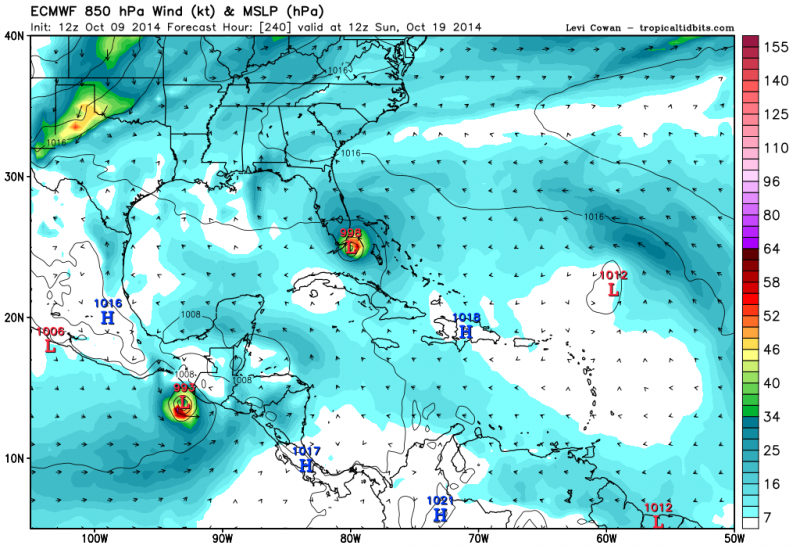
against my better judgement but here goes..what is the gfs doing with this system?


The 00Z and 06Z GFS showed some gradual development with the system impacting Florida in the 06Z in the long-range. The 12Z GFS seems to take it over Hispaniola so it doesn't seem to get going but it heads west. The system under discussion is this one:

viewtopic.php?f=31&t=116827
0 likes   

HURRICANELONNY
Category 5
Category 5
Posts: 1381
Joined: Wed May 07, 2003 6:48 am
Location: HOLLYWOOD.FL

Re: Global Model Runs Discussion

#7982 Postby HURRICANELONNY » Thu Oct 09, 2014 3:24 pm

Don't make sense because a front suppose to stall over S.FL. next wendsday.

long range models are forecasting the high over the Florida
Peninsula to move east into the Atlantic waters early next week.
This will allow for a cold front over the northwestern United States
to move southeast this weekend across the central United States and
into northern Florida early next week. The long range models
continue to move the cold front southward and into South Florida by
the middle of next week before stalling it out over South Florida
for late next week.
0 likes   
hurricanelonny

User avatar
NDG
S2K Supporter
S2K Supporter
Posts: 14934
Joined: Sun Jul 09, 2006 10:14 pm
Location: Orlando, FL

Re: Global Model Runs Discussion

#7983 Postby NDG » Thu Oct 09, 2014 5:32 pm

As good as I may put the Euro this year I am not buying its 240 hr forecast, this is the first run that shows another system to form north of the Lesser Antilles and head westward towards S FL.

Image
0 likes   

HURRICANELONNY
Category 5
Category 5
Posts: 1381
Joined: Wed May 07, 2003 6:48 am
Location: HOLLYWOOD.FL

Re: Global Model Runs Discussion

#7984 Postby HURRICANELONNY » Thu Oct 09, 2014 5:53 pm

I think the euro got a case of gfs. :roll:
0 likes   
hurricanelonny

Dean4Storms
S2K Supporter
S2K Supporter
Posts: 6355
Age: 61
Joined: Sun Aug 31, 2003 1:01 pm
Location: Miramar Bch. FL

#7985 Postby Dean4Storms » Thu Oct 09, 2014 5:58 pm

These models are dancing all over the place. When that happens you just have to watch for consistency and see if it gets inside 5 days along with other models latching into it.
0 likes   

User avatar
Hammy
Category 5
Category 5
Posts: 5594
Age: 40
Joined: Fri May 25, 2012 5:25 pm
Contact:

#7986 Postby Hammy » Thu Oct 09, 2014 6:05 pm

The exact track may not pan out but it still gives a good idea that something will likely be headed towards the Bahamas in the next week or so. The models don't base things on climatology but real time factors (except the GFS, which sits around fantasizing all day) so I wouldn't write off the model run just because it doesn't seem like something that would normally happen. And when the model drops it tomorrow, don't get the false sense that it was incorrect as it'll likely show back up a few days later.

Also keep in mind we had an unclassified system in 2003 move east-to-west for several days including across the Bahamas and S Florida, and this was in November, so the track shown isn't by any means impossible.
0 likes   
The above post is not official and should not be used as such. It is the opinion of the poster and may or may not be backed by sound meteorological data. It is not endorsed by any professional institution or storm2k.org. For official information, please refer to the NHC and NWS products.

User avatar
weatherwindow
Category 4
Category 4
Posts: 904
Joined: Mon Sep 20, 2004 9:48 am
Location: key west/ft lauderdale

Re: Global Model Runs Discussion

#7987 Postby weatherwindow » Thu Oct 09, 2014 6:38 pm

[quote="blp"]Well the 12z UKMet is also showing something like the Euro. That is a strange path for October, it looks like September. 2014 has been just one big headache.

http://weather.unisys.com/hurricane/atl ... /track.gif

Unusual but not without precedent....in addition, similiar genesis northeast of Leewards

http://www.aoml.noaa.gov/general/lib/li ... s/1941.pdf
0 likes   

User avatar
Hammy
Category 5
Category 5
Posts: 5594
Age: 40
Joined: Fri May 25, 2012 5:25 pm
Contact:

#7988 Postby Hammy » Thu Oct 09, 2014 6:46 pm

Looking at the 1941 system, Kate in 1985 (in November, so even more unusual) also springs to mind.
0 likes   
The above post is not official and should not be used as such. It is the opinion of the poster and may or may not be backed by sound meteorological data. It is not endorsed by any professional institution or storm2k.org. For official information, please refer to the NHC and NWS products.

User avatar
SFLcane
S2K Supporter
S2K Supporter
Posts: 9620
Age: 46
Joined: Sat Jun 05, 2010 1:44 pm
Location: Lake Worth Florida

Re: Global Model Runs Discussion

#7989 Postby SFLcane » Thu Oct 09, 2014 6:55 pm

0 likes   

weatherfanatic
Tropical Depression
Tropical Depression
Posts: 58
Age: 42
Joined: Sun Jun 29, 2014 7:52 am
Location: Yonkers, NY

#7990 Postby weatherfanatic » Fri Oct 10, 2014 12:03 am

Our old friend 00z GFS is up to its tricks again but its really concerning IF even 1% chance its right 13 days out for a giant storm to retrograde into cape cod with winds gusting to 80mph, encompassing a area similar in size top you know who 2 years ago and one week later. And it all comes from the area near Eastern Yucatan Hmmmm. That article posted above is interesting to say the least may need to watch for a big system sometime in last 2 weeks of October. I am not letting it fool me at this time but thats just a bit jarring to see that after living through 2012 myself here in NY. Not the first run showing that (of course we know Model U has shown many consecutive runs of things not happening). But this particular run just had my jaw drop. :eek:
0 likes   
This post is NOT AN OFFICIAL FORECAST and should not be used as such. It is just the opinion of the poster and may or may not be backed by sound meteorological data. It is NOT endorsed by any professional institution including storm2k.org. For Official Information please refer to the NHC and NWS products.

User avatar
Hammy
Category 5
Category 5
Posts: 5594
Age: 40
Joined: Fri May 25, 2012 5:25 pm
Contact:

Re: Global Model Runs Discussion

#7991 Postby Hammy » Fri Oct 10, 2014 1:22 am

Euro continues to show a system developing and moving in the general direction of Florida, and it appears that it's now bumped up the development to 96 hours from >120 hours since the last run.

edit: no longer shows it going into Florida, but now shows a strong Cat 2 meandering in the Bahamas...
0 likes   
The above post is not official and should not be used as such. It is the opinion of the poster and may or may not be backed by sound meteorological data. It is not endorsed by any professional institution or storm2k.org. For official information, please refer to the NHC and NWS products.

weatherfanatic
Tropical Depression
Tropical Depression
Posts: 58
Age: 42
Joined: Sun Jun 29, 2014 7:52 am
Location: Yonkers, NY

#7992 Postby weatherfanatic » Fri Oct 10, 2014 6:28 am

Actaully Hammy on the high resolution Euro from wxbell.com the winds at 240 hrs are 119mph, Cat 3! And the GFS still trying to be a funny pants and show a major monster storm in the long range around 23rd. This is the GFS last chance to make a stand, and the Euro too for this possible cat 3 hurricane.
0 likes   
This post is NOT AN OFFICIAL FORECAST and should not be used as such. It is just the opinion of the poster and may or may not be backed by sound meteorological data. It is NOT endorsed by any professional institution including storm2k.org. For Official Information please refer to the NHC and NWS products.

weatherfanatic
Tropical Depression
Tropical Depression
Posts: 58
Age: 42
Joined: Sun Jun 29, 2014 7:52 am
Location: Yonkers, NY

#7993 Postby weatherfanatic » Fri Oct 10, 2014 11:25 am

With the way things suddenly started heating up I can see 3-4 named storms coming out the next few weeks. Just my opinion but we will probably have Fay soon, and then 90L looks to really ramp up if Euro is right and to be 91L looks very impressive. And there is still long range support for future development in the carribbean, making up for lost time maybe!
0 likes   
This post is NOT AN OFFICIAL FORECAST and should not be used as such. It is just the opinion of the poster and may or may not be backed by sound meteorological data. It is NOT endorsed by any professional institution including storm2k.org. For Official Information please refer to the NHC and NWS products.

User avatar
gatorcane
S2K Supporter
S2K Supporter
Posts: 23499
Age: 46
Joined: Sun Mar 13, 2005 3:54 pm
Location: Boca Raton, FL

#7994 Postby gatorcane » Fri Oct 10, 2014 3:49 pm

12Z NAVGEM has a low moving into the NW Caribbean next week which eventually develops out ahead of the big cold front expected to sweep through the Eastern CONUS.

Image
0 likes   

User avatar
gatorcane
S2K Supporter
S2K Supporter
Posts: 23499
Age: 46
Joined: Sun Mar 13, 2005 3:54 pm
Location: Boca Raton, FL

#7995 Postby gatorcane » Sat Oct 11, 2014 8:28 am

NAVGEM has been very consistent in developing a Western Caribbean system next week. Here is how the run ends at 180 hours with a strong cane heading NE towards South Florida / Keys:

Image

The FIM has been consistent in showing something as well though the point of origin seems to be different than the NAVGEM. 168 hours below:
Image
0 likes   

User avatar
TheStormExpert
Category 5
Category 5
Posts: 8487
Age: 30
Joined: Wed Feb 16, 2011 5:38 pm
Location: Palm Beach Gardens, FL

#7996 Postby TheStormExpert » Sat Oct 11, 2014 10:42 am

:uarrow: I'll believe it when the Euro shows it which will probably never happen. :lol:
0 likes   
The following post is NOT an official forecast and should not be used as such. It is just the opinion of the poster and may or may not be backed by sound meteorological data. It is NOT endorsed by storm2k.org.

User avatar
Hammy
Category 5
Category 5
Posts: 5594
Age: 40
Joined: Fri May 25, 2012 5:25 pm
Contact:

Re:

#7997 Postby Hammy » Sat Oct 11, 2014 11:00 am

TheStormExpert wrote::uarrow: I'll believe it when the Euro shows it which will probably never happen. :lol:


I've already given up on anything forming in the Caribbean at this point.
0 likes   
The above post is not official and should not be used as such. It is the opinion of the poster and may or may not be backed by sound meteorological data. It is not endorsed by any professional institution or storm2k.org. For official information, please refer to the NHC and NWS products.

User avatar
Yellow Evan
Professional-Met
Professional-Met
Posts: 15959
Age: 25
Joined: Fri Jul 15, 2011 12:48 pm
Location: Henderson, Nevada/Honolulu, HI
Contact:

#7998 Postby Yellow Evan » Sat Oct 11, 2014 11:46 am

Untill NHC mentions it, assume anything the GFS shows in the WCARB will get switched to EPAC at some point.
0 likes   

User avatar
gatorcane
S2K Supporter
S2K Supporter
Posts: 23499
Age: 46
Joined: Sun Mar 13, 2005 3:54 pm
Location: Boca Raton, FL

#7999 Postby gatorcane » Sat Oct 11, 2014 12:01 pm

12Z GFS shows a genesis starting in the NW Caribbean near Belize in 144 hours. The system is ejected NE out of the NW Caribbean to the NE into Florida. Let's see if the Euro joins. As bad as the GFS has been this year, I will point out the GFS sniffed out 90l before the Euro did.

Here is the 192 hour graphic before the model switches to lower resolution:
Image
0 likes   

User avatar
Hammy
Category 5
Category 5
Posts: 5594
Age: 40
Joined: Fri May 25, 2012 5:25 pm
Contact:

Re:

#8000 Postby Hammy » Sat Oct 11, 2014 1:40 pm

gatorcane wrote:As bad as the GFS has been this year, I will point out the GFS sniffed out 90l before the Euro did.


This area in particular seems to be a major trouble area with the GFS though, as it's been sniffing out systems here all season, and not one has actually formed.
0 likes   
The above post is not official and should not be used as such. It is the opinion of the poster and may or may not be backed by sound meteorological data. It is not endorsed by any professional institution or storm2k.org. For official information, please refer to the NHC and NWS products.


Return to “2015”

Who is online

Users browsing this forum: No registered users and 3 guests