possibility of GOM action later in week? (is INVEST 98L)
Moderator: S2k Moderators
Forum rules

The posts in this forum are NOT official forecasts and should not be used as such. They are just the opinion of the poster and may or may not be backed by sound meteorological data. They are NOT endorsed by any professional institution or STORM2K. For official information, please refer to products from the National Hurricane Center and National Weather Service.

Maybe. But this feature is at the butt end of a trough, so if it forms, it will be one of those times. Without looking at the surface maps, I'm assuming Gulf 1 is currently an upper feature. We have a reverse sea breeze/land breeze thunderstorm band crossing now with thunder and lightning. I think with the rotation around the mid or upper low, you have storms forming over water and feeding into land at night. We don't typically get thunderstorms at 10:30pm in the summer without a triggering mechanism. Other than the lightning and the storms feeding in from the east (as opposed to southeast) outside feels tropical. Barometric pressure is lower than it has been by a good bit but maybe not so low to think anything nearby is close to the surface yet. Jmo
0 likes
-
tropicwatch

- Category 5

- Posts: 3205
- Age: 60
- Joined: Sat Jun 02, 2007 10:01 am
- Location: Panama City Florida
- Contact:
Re: possibility of GOM action later in week?
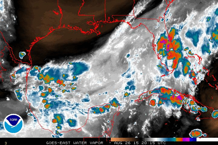
Water vapor imagery center GOM that has some dry air but the 850mb vorticity keeps increasing.

Are they both close to the surface?
Are they both close to the surface?
0 likes
Tropicwatch
Agnes 72', Eloise 75, Elena 85', Kate 85', Charley 86', Florence 88', Beryl 94', Dean 95', Erin 95', Opal 95', Earl 98', Georges 98', Ivan 2004', Arlene 2005', Dennis 2005', Ida 2009' Debby 2012' Irma 2017' Michael 2018'
Agnes 72', Eloise 75, Elena 85', Kate 85', Charley 86', Florence 88', Beryl 94', Dean 95', Erin 95', Opal 95', Earl 98', Georges 98', Ivan 2004', Arlene 2005', Dennis 2005', Ida 2009' Debby 2012' Irma 2017' Michael 2018'

Re: possibility of GOM action later in week?
Senobia wrote:I don't think there is enough of this left over water to develop.
That said, we had some crazy winds blow through SETX this evening...I mean crazy winds.

Same here, Senobia. We had these storms move through around 5:00 p.m. and the lightning and winds were ferocious. Ended up receiving close to 2 inches of rain. Crazy winds indeed.
0 likes
Audrey (1957), Carla (1961), Hilda (1964), Betsy (1965), Edith (1971), Carmen (1974), Danny (1985), Juan (1985), Andrew (1992), Lili (2002), Rita (2005), Gustav (2008), Ike (2008), and stuck in the eye of Iniki (1992) while vacationing in Kauai.
Not an official forecast by any means.
Not an official forecast by any means.
-
cycloneye

- Admin

- Posts: 139525
- Age: 67
- Joined: Thu Oct 10, 2002 10:54 am
- Location: San Juan, Puerto Rico
Re: possibility of GOM action later in week?
Is mentioned at 8 AM TWO:
Disorganized showers and thunderstorms over the northern Gulf of
Mexico are associated with a trough of low pressure. Upper-level
winds are not expected to be conducive for significant development
while the system moves to the west-southwest at 5 to 10 mph.
* Formation chance through 48 hours...low...10 percent.
* Formation chance through 5 days...low...10 percent.
0 likes
Visit the Caribbean-Central America Weather Thread where you can find at first post web cams,radars
and observations from Caribbean basin members Click Here
and observations from Caribbean basin members Click Here
-
tolakram
- Admin
- Posts: 19176
- Age: 60
- Joined: Sun Aug 27, 2006 8:23 pm
- Location: Florence, KY (name is Mark)
Re: possibility of GOM action later in week?
Live IR. Some spin might be evident.
http://wwwghcc.msfc.nasa.gov/cgi-bin/get-goes?satellite=GOES-E%20CONUS&lat=27&lon=-91&info=ir&zoom=1&width=1000&height=800&quality=95&type=Animation&palette=ir3.pal&numframes=20
http://wwwghcc.msfc.nasa.gov/cgi-bin/get-goes?satellite=GOES-E%20CONUS&lat=27&lon=-91&info=ir&zoom=1&width=1000&height=800&quality=95&type=Animation&palette=ir3.pal&numframes=20
0 likes
M a r k
- - - - -
Join us in chat: Storm2K Chatroom Invite. Android and IOS apps also available.
The posts in this forum are NOT official forecasts and should not be used as such. Posts are NOT endorsed by any professional institution or STORM2K.org. For official information and forecasts, please refer to NHC and NWS products.
-
tropicwatch
- Category 5
- Posts: 3205
- Age: 60
- Joined: Sat Jun 02, 2007 10:01 am
- Location: Panama City Florida
- Contact:
Re: possibility of GOM action later in week?
This is something you don't see everyday, covers a massive area.

0 likes
Tropicwatch
Agnes 72', Eloise 75, Elena 85', Kate 85', Charley 86', Florence 88', Beryl 94', Dean 95', Erin 95', Opal 95', Earl 98', Georges 98', Ivan 2004', Arlene 2005', Dennis 2005', Ida 2009' Debby 2012' Irma 2017' Michael 2018'
Agnes 72', Eloise 75, Elena 85', Kate 85', Charley 86', Florence 88', Beryl 94', Dean 95', Erin 95', Opal 95', Earl 98', Georges 98', Ivan 2004', Arlene 2005', Dennis 2005', Ida 2009' Debby 2012' Irma 2017' Michael 2018'
-
greg_kfdm_tv
- Professional-Met

- Posts: 110
- Joined: Fri Aug 29, 2003 8:50 pm
- Location: Beaumont, Texas
- Contact:
-
wxman57

- Moderator-Pro Met

- Posts: 22499
- Age: 66
- Joined: Sat Jun 21, 2003 8:06 pm
- Location: Houston, TX (southwest)
Re: possibility of GOM action later in week?
Good morning, Greg. I can see a very weak spin in the obs south of Morgan City, but about 200 miles offshore. Winds are very light in the northern Gulf, with the exception of near SE LA behind the weak cold front. Development is unlikely, but the system will result in increased daytime storms across the Texas coast over the next few days. I think we have to watch the SW Caribbean by this weekend for something to materialize that could develop in the Gulf next week. Labor Day weekend is coming up and I almost NEVER have a storm-free Labor Day weekend.

0 likes
-
greg_kfdm_tv
- Professional-Met
- Posts: 110
- Joined: Fri Aug 29, 2003 8:50 pm
- Location: Beaumont, Texas
- Contact:
-
wxman57
- Moderator-Pro Met
- Posts: 22499
- Age: 66
- Joined: Sat Jun 21, 2003 8:06 pm
- Location: Houston, TX (southwest)
Re:
greg_kfdm_tv wrote:Good morning, Chris. Just noticed that platform KGHB (27.83 north and 91.99 west) has a west wind at 6 knots. However, it could be locally enhanced by convection near the platform. Would love to see some rain at my place...very dry....only 1 inch this month.
Not much convection at all in the Gulf, and little time before it all moves inland. Rain maker for TX/LA, but nothing more, most likely. I'm at just about 7" for August after measuring 8" in July. You can have my rain this week.
0 likes

Re: possibility of GOM action later in week?
drezee Mon Aug 25, 2014 2:34 pm wrote:Right now it is nothing by outflow boundaries...
The only hope is the NW corner which might feedback over time if it doesn't also collapse
The NW part indeed survived the onslaught of outflow boundaries. Wxman57, I agree there isn't much time. The Euro hinted at the GOM system next week and it makes sense given the orientation of the Atlantic ridge. I actually think the beginnings of the system is over SA right now at about 5N 65W...
0 likes


Re: possibility of GOM action later in week?
What was Alicia, about 300 miles south of Mississippi when it got started?
0 likes
-
srainhoutx

- S2K Supporter

- Posts: 6919
- Age: 66
- Joined: Sun Jan 14, 2007 11:34 am
- Location: Haywood County, NC
- Contact:
Re: possibility of GOM action later in week?
TexWx wrote:What was Alicia, about 300 miles south of Mississippi when it got started?
South of Louisiana when it finally spun up.
0 likes
Carla/Alicia/Jerry(In The Eye)/Michelle/Charley/Ivan/Dennis/Katrina/Rita/Wilma/Ike/Harvey
Member: National Weather Association
Wx Infinity Forums
http://wxinfinity.com/index.php
Facebook.com/WeatherInfinity
Twitter @WeatherInfinity
Member: National Weather Association
Wx Infinity Forums
http://wxinfinity.com/index.php
Facebook.com/WeatherInfinity
Twitter @WeatherInfinity
Re: possibility of GOM action later in week?
The Gulf of Mexico is worth watching
In the Gulf of Mexico, heavy thunderstorm activity has diminished since Monday along a weak cold front stretching from South Florida to the Louisiana coastal waters. Some models show a weak area of low pressure developing along this front and moving westwards over Texas by Friday, and we should keep an eye on this region for development.
http://www.wunderground.com/blog/JeffMa ... rynum=2776
I don't understand what they are 'developing'. Is it this area I circled in green? If so, is this really going to stay offshore until Friday, as they suggest? Seems like an awfully long time.

Satellite image from a few minutes ago
Last edited by Senobia on Tue Aug 26, 2014 9:47 am, edited 1 time in total.
0 likes
-
somethingfunny

- ChatStaff

- Posts: 3926
- Age: 35
- Joined: Thu May 31, 2007 10:30 pm
- Location: McKinney, Texas
Re: possibility of GOM action later in week?
I wasn't going to bring up Alicia because I really don't intend to make any comparison of impact between this system and that one, but since we're here:
When did the potential of a strong storm get noticed by our meteorologists and forecast models in 1983, and has anyone seen how well today's computer models might forsee Alicia in a historical simulation?
When did the potential of a strong storm get noticed by our meteorologists and forecast models in 1983, and has anyone seen how well today's computer models might forsee Alicia in a historical simulation?
0 likes
I am not a meteorologist, and any posts made by me are not official forecasts or to be interpreted as being intelligent. These posts are just my opinions and are probably silly opinions.
-
Portastorm

- Storm2k Moderator

- Posts: 9787
- Age: 61
- Joined: Fri Jul 11, 2003 9:16 am
- Location: South Austin, TX
- Contact:
Re: Re:
wxman57 wrote:greg_kfdm_tv wrote:Good morning, Chris. Just noticed that platform KGHB (27.83 north and 91.99 west) has a west wind at 6 knots. However, it could be locally enhanced by convection near the platform. Would love to see some rain at my place...very dry....only 1 inch this month.
Not much convection at all in the Gulf, and little time before it all moves inland. Rain maker for TX/LA, but nothing more, most likely. I'm at just about 7" for August after measuring 8" in July. You can have my rain this week.
We'll gladly take your rain here in south central Texas, wxman57. Send plenty please.
0 likes
Any forecasts under my name are to be taken with a grain of salt. Get your best forecasts from the National Weather Service and National Hurricane Center.
I'm a certified Advanced SKYWARN-trained spotter and am active on Twitter at @TravisCOSW, a social media partner of the NWS Austin-San Antonio office.
I'm a certified Advanced SKYWARN-trained spotter and am active on Twitter at @TravisCOSW, a social media partner of the NWS Austin-San Antonio office.
-
blazess556
- Professional-Met
- Posts: 250
- Joined: Mon Aug 31, 2009 10:51 pm
- Location: Germantown, MD
Re: possibility of GOM action later in week?
Looks like we may have AF 304 investigating the disturbance in the Gulf.
0 likes
-
TeamPlayersBlue

- Category 5
- Posts: 3310
- Joined: Tue Feb 02, 2010 1:44 am
- Location: Denver/Applewood, CO
I leave town for ONE MINUTE. Im in Canada till Thursday. Real odds of something popping up? That wind shear map above looked crazy. Wind field is massive. Is it all upper level energy or what? Sorry been out of the loop for almost a week. Also, going to Junction on Friday for Opening of Dove season and as my friends trusted meteorologist, they expect me to tell them if anything major like this were to dampen our plans a bit
0 likes
Personal Forecast Disclaimer:
The posts in this forum are NOT official forecast and should not be used as such. They are just the opinion of the poster and may or may not be backed by sound meteorological data. They are NOT endorsed by any professional institution or storm2k.org. For official information, please refer to the NHC and NWS products.
The posts in this forum are NOT official forecast and should not be used as such. They are just the opinion of the poster and may or may not be backed by sound meteorological data. They are NOT endorsed by any professional institution or storm2k.org. For official information, please refer to the NHC and NWS products.
-
Hurricaneman

- Category 5
- Posts: 7284
- Age: 43
- Joined: Tue Aug 31, 2004 3:24 pm
- Location: central florida
Re: possibility of GOM action later in week?
blazess556 wrote:Looks like we may have AF 304 investigating the disturbance in the Gulf.
based on that shouldn't this be an invest or am I losing it and while this looks good and all its problem will be space as it will not have a lot of time to do much
The posts in this forum are NOT official forecast and should not be used as such. They are just the opinion of the poster and may or may not be backed by sound meteorological data. They are NOT endorsed by any professional institution or storm2k.org. For official information, please refer to the NHC and NWS products
0 likes
Who is online
Users browsing this forum: duilaslol, Hybridstorm_November2001, skyline385, Stratton23, Wampadawg and 52 guests