2020 Global Model Runs Discussion (Out thru day 16)
Moderator: S2k Moderators
Forum rules
The posts in this forum are NOT official forecasts and should not be used as such. They are just the opinion of the poster and may or may not be backed by sound meteorological data. They are NOT endorsed by any professional institution or STORM2K. For official information, please refer to products from the National Hurricane Center and National Weather Service.
- gatorcane
- S2K Supporter
- Posts: 23499
- Age: 46
- Joined: Sun Mar 13, 2005 3:54 pm
- Location: Boca Raton, FL
Re: 2020 Global Model Runs Discussion (Out thru day 16)
Indeed looks like some subtropical development off the SE US Coast / Bahamas is looking possible.The 12Z Euro is showing a more defined area of low pressure while the 18Z GEFS looking more bullish. The Euro turns it west under a 500MB ridge into Florida but long-range, while the GFS sends it OTS:
0 likes
- AJC3
- Admin
- Posts: 3876
- Age: 60
- Joined: Tue Aug 31, 2004 7:04 pm
- Location: West Melbourne, Florida
- Contact:
Re: 2020 Global Model Runs Discussion (Out thru day 16)
Gang,
If anyone is looking for the several posts that were in this thread that started talking about seasonal climatology, they've been moved over to the appropriate thread. Feel free to continue the discussion over there, but let's keep it civil and not escalate the snark.
Thanks.
If anyone is looking for the several posts that were in this thread that started talking about seasonal climatology, they've been moved over to the appropriate thread. Feel free to continue the discussion over there, but let's keep it civil and not escalate the snark.
Thanks.
3 likes
Re: 2020 Global Model Runs Discussion (Out thru day 16)
GFS and Navy are persistent with this development off the Georgia coast on May 16th. That's only 5 days out now. Time to start paying attention?
1 likes
Eyes: Emily '86, Dean '89, Felix '95, Gert '99, Fabian '03, Humberto '19, Paulette '20
Re: 2020 Global Model Runs Discussion (Out thru day 16)
12z GFS has a potential Bermuda threat:
0 likes
Eyes: Emily '86, Dean '89, Felix '95, Gert '99, Fabian '03, Humberto '19, Paulette '20
-
- Category 5
- Posts: 2434
- Age: 31
- Joined: Thu Sep 07, 2017 3:39 pm
- Location: St. Petersburg, FL → Scandinavia
Re: 2020 Global Model Runs Discussion (Out thru day 16)
0 likes
CVW / MiamiensisWx / Shell Mound
The posts in this forum are NOT official forecasts and should not be used as such. They are just the opinion of the poster and may or may not be backed by sound meteorological data. They are NOT endorsed by any professional institution or STORM2K. For official information, please refer to products from the NHC and NWS.
Re: 2020 Global Model Runs Discussion (Out thru day 16)
CMC, NAVGEM, JMA also on board now.
CMC is showing a pretty aggressive warm core riding the Gulf Stream.
1 likes
- Kazmit
- Category 5
- Posts: 1915
- Age: 21
- Joined: Mon Jul 25, 2016 8:49 am
- Location: Williamsburg VA for college, Bermuda otherwise
Re: 2020 Global Model Runs Discussion (Out thru day 16)
Seems like consolidation would happen in 5, maybe 4, days from now. If trends continue I think we'll see a mention from the NHC tomorrow.
0 likes
Igor 2010, Sandy 2012, Fay 2014, Gonzalo 2014, Joaquin 2015, Nicole 2016, Humberto 2019
I am only a tropical weather enthusiast. My predictions are not official and may or may not be backed by sound meteorological data. For official information, please refer to the NHC and NWS products.
- CyclonicFury
- Category 5
- Posts: 1977
- Age: 25
- Joined: Sun Jul 02, 2017 12:32 pm
- Location: NC
- Contact:
Re: 2020 Global Model Runs Discussion (Out thru day 16)
This afternoon's WPC discussion suggests an NHC mention is likely coming within the next few days if models hold:
https://www.wpc.ncep.noaa.gov/discussio ... isc=pmdepd
Elsewhere, the trailing end of a stationary frontal boundary is
forecast to linger in the vicinity of South Florida and the
Bahamas through late in the week, before an area of low pressure
along the boundary forms and moves northeastward away from the
state. This boundary is expected to focus showers and
thunderstorms, with the potential for locally heavy rains across
South Florida Thu and Fri, before activity begins to shift east of
the state over the weekend. The National Hurricane Center and
Tropical Analysis and Forecast Branch (TAFB) are monitoring this
area for potential development as a sub-tropical or tropical
system by this weekend. The late afternoon fronts update will
reflect the forecast evolution of the system from the 17Z
coordination call today.
4 likes
NCSU B.S. in Meteorology Class of 2021. Tropical weather blogger at http://www.cyclonicfury.com. My forecasts and thoughts are NOT official, for official forecasts please consult the National Hurricane Center.
- cycloneye
- Admin
- Posts: 139514
- Age: 67
- Joined: Thu Oct 10, 2002 10:54 am
- Location: San Juan, Puerto Rico
Re: 2020 Global Model Runs Discussion (Out thru day 16)
1 likes
Visit the Caribbean-Central America Weather Thread where you can find at first post web cams,radars
and observations from Caribbean basin members Click Here
-
- S2K Supporter
- Posts: 6355
- Age: 61
- Joined: Sun Aug 31, 2003 1:01 pm
- Location: Miramar Bch. FL
Re: 2020 Global Model Runs Discussion (Out thru day 16)
The ECM Ensembles have several members with Lows over the Western Gulf by early to mid next week with one member producing a 990mb storm. Graphic I saw of the ECM ENS was at 20% on TD development over the NW Gulf of Mexico next week.
0 likes
- TheStormExpert
- Category 5
- Posts: 8487
- Age: 30
- Joined: Wed Feb 16, 2011 5:38 pm
- Location: Palm Beach Gardens, FL
Re: 2020 Global Model Runs Discussion (Out thru day 16)
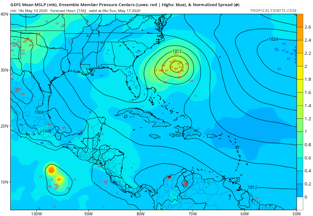
Dean4Storms wrote:The ECM Ensembles have several members with Lows over the Western Gulf by early to mid next week with one member producing a 990mb storm. Graphic I saw of the ECM ENS was at 20% on TD development over the NW Gulf of Mexico next week.
Yep, wouldn’t that be something if we saw Bertha too before the official start of the season! Of course if wouldn’t be the first time since it has occurred twice within the past decade where we’ve seen two named storms prior to June 1st, both 2012 and 2016 for anyone who forgot.
2 likes
The following post is NOT an official forecast and should not be used as such. It is just the opinion of the poster and may or may not be backed by sound meteorological data. It is NOT endorsed by storm2k.org.
- TheStormExpert
- Category 5
- Posts: 8487
- Age: 30
- Joined: Wed Feb 16, 2011 5:38 pm
- Location: Palm Beach Gardens, FL
Re: 2020 Global Model Runs Discussion (Out thru day 16)
Just an FYI, the Euro has not been performing well. Definitely not living up to its old self!
https://twitter.com/hurrtrackerapp/status/1260922489657602048
1 likes
The following post is NOT an official forecast and should not be used as such. It is just the opinion of the poster and may or may not be backed by sound meteorological data. It is NOT endorsed by storm2k.org.
-
- Admin
- Posts: 19175
- Age: 60
- Joined: Sun Aug 27, 2006 8:23 pm
- Location: Florence, KY (name is Mark)
Re: 2020 Global Model Runs Discussion (Out thru day 16)
That performance is typical for the globals when in a seasonal transition. See how they all dip?
0 likes
M a r k
- - - - -
Join us in chat: Storm2K Chatroom Invite. Android and IOS apps also available.
The posts in this forum are NOT official forecasts and should not be used as such. Posts are NOT endorsed by any professional institution or STORM2K.org. For official information and forecasts, please refer to NHC and NWS products.
- TheStormExpert
- Category 5
- Posts: 8487
- Age: 30
- Joined: Wed Feb 16, 2011 5:38 pm
- Location: Palm Beach Gardens, FL
Re: 2020 Global Model Runs Discussion (Out thru day 16)
tolakram wrote:That performance is typical for the globals when in a seasonal transition. See how they all dip?
Yes, but if I recall the Euro wasn’t performing to well even last season. It seemed to be all over the place unless it was within 3-5 days of occurring.
0 likes
The following post is NOT an official forecast and should not be used as such. It is just the opinion of the poster and may or may not be backed by sound meteorological data. It is NOT endorsed by storm2k.org.
-
- S2K Supporter
- Posts: 6355
- Age: 61
- Joined: Sun Aug 31, 2003 1:01 pm
- Location: Miramar Bch. FL
Re: 2020 Global Model Runs Discussion (Out thru day 16)
Yea, the 12z Today dropped that chance to 10% so looking doubtful on a Gulf development next week.
Looking at the MJO, the long term 500mb pattern and the JMA it is fair to say that early to mid-June might produce an early season storm, but we all know how the tropics can be.
0 likes
- HurricaneEnzo
- Category 2
- Posts: 724
- Joined: Wed Mar 14, 2018 12:18 pm
- Location: Newport, NC (Hurricane Alley)
Re: 2020 Global Model Runs Discussion (Out thru day 16)
TheStormExpert wrote:Just an FYI, the Euro has not been performing well. Definitely not living up to its old self!
https://twitter.com/hurrtrackerapp/status/1260922489657602048
Ok so I thought I knew how to read these charts but apparently not? Looks like the Euro has been marginally better than the GFS/CMC. Numbers for 90 days, 30 days, and 7 days are all highest. Higher number is better right? Plus just looking at the chart it would still appear to be tops overall for 500mb. So maybe it hasn't been as good as usual but it doesn't look to have been worse than GFS/CMC as the tweet implies.
EDIT- I see it now 'Hurricane Updates' apparently misunderstood the original tweet. The original was just talking about 1 data point and said all models have been pretty poor last 1.5 months. National Hurricane Updates or whoever that is turned it into its been worse than the GFS/CMC the last 1.5 months. Carry on nothing to see here lol.
0 likes
Bertha 96' - Fran 96' - Bonnie 98' - Dennis 99' - Floyd 99' - Isabel 03' - Alex 04' - Ophelia 05' - Irene 11' - Arthur 14' - Matthew 16' - Florence 18' - Dorian 19' - Isaias 20' (countless other tropical storms and Hurricane swipes)
I am not a Professional Met just an enthusiast. Get your weather forecasts from the Pros!
- Hurricaneman
- Category 5
- Posts: 7284
- Age: 43
- Joined: Tue Aug 31, 2004 3:24 pm
- Location: central florida
Re: 2020 Global Model Runs Discussion (Out thru day 16)
The 18zGFS seems to show a western Caribbean monsoon trough past 15 days. Let’s see if it comes in in time or even starts to hint at development in the early part of June
3 likes
Re: 2020 Global Model Runs Discussion (Out thru day 16)
Is that a wave hitting the upper TX coast on the 12z Euro?
1 likes
- TheStormExpert
- Category 5
- Posts: 8487
- Age: 30
- Joined: Wed Feb 16, 2011 5:38 pm
- Location: Palm Beach Gardens, FL
Re: 2020 Global Model Runs Discussion (Out thru day 16)
Just posted this too in the indicators thread.
A TC in the Western Caribbean or East Pacific seems likely at this point during the first week of June.
https://twitter.com/webberweather/status/1262359461290745857
A TC in the Western Caribbean or East Pacific seems likely at this point during the first week of June.
https://twitter.com/webberweather/status/1262359461290745857
0 likes
The following post is NOT an official forecast and should not be used as such. It is just the opinion of the poster and may or may not be backed by sound meteorological data. It is NOT endorsed by storm2k.org.
Re: 2020 Global Model Runs Discussion (Out thru day 16)
My feeling that it will be pulled towards the NW Caribbean/southern GOM due to persistent troughiness over the south central US/MS river valley.
0 likes
Who is online
Users browsing this forum: AnnularCane, beachbum123, cstrunk, Google Adsense [Bot], HurricaneBelle, jlauderdal, Kazmit, LarryWx, skyline385, South Texas Storms, tolakram, Wampadawg and 46 guests