2017 indicators: SST's / MSLP / SAL / Steering / Instability

This is the general tropical discussion area. Anyone can take their shot at predicting a storms path.

Moderator: S2k Moderators
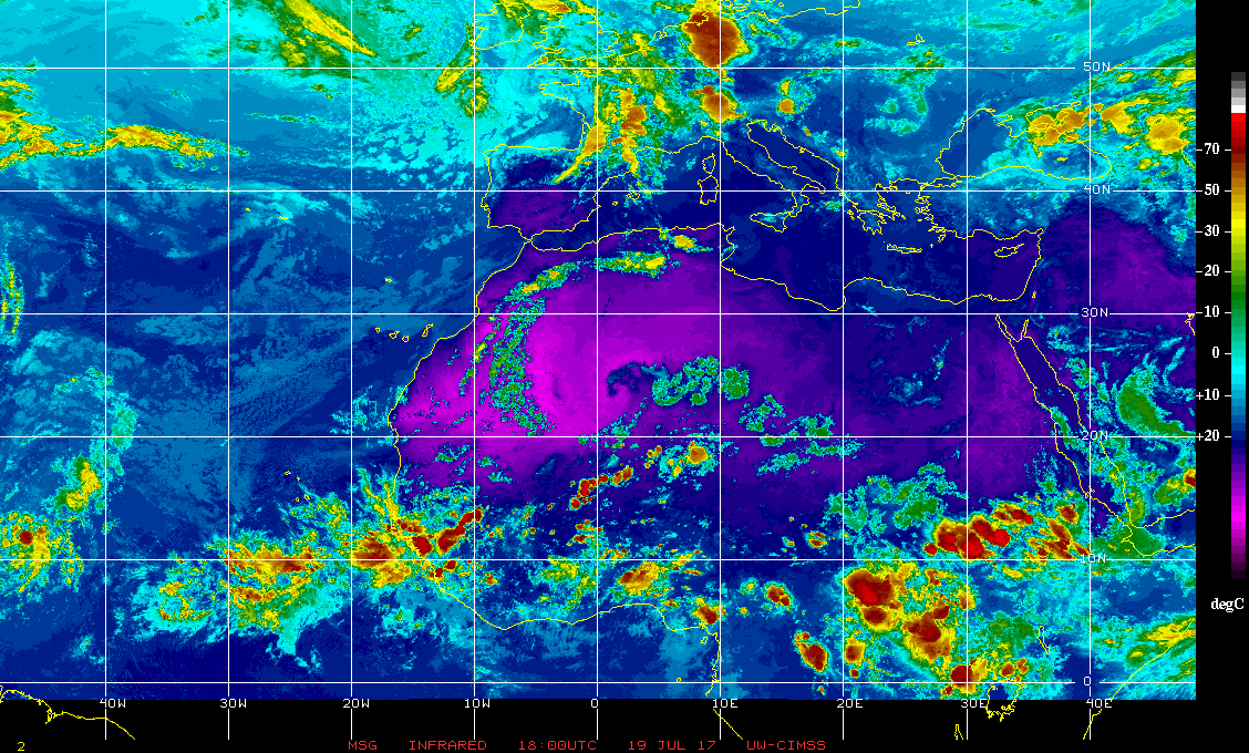
Forum rules

The posts in this forum are NOT official forecasts and should not be used as such. They are just the opinion of the poster and may or may not be backed by sound meteorological data. They are NOT endorsed by any professional institution or STORM2K. For official information, please refer to products from the National Hurricane Center and National Weather Service.

Help Support Storm2K
Message
Author
Weather150
Tropical Storm
Tropical Storm
Posts: 190
Joined: Fri Jul 07, 2017 7:46 pm

Re: 2017 indicators: SST's / MSLP / SAL / Steering / Instability

#801 Postby Weather150 » Wed Jul 19, 2017 5:13 pm

Image
Waves starting to come off at higher latitudes than they were 2-3 weeks ago, the progression northward is happening.
2 likes   

User avatar
NDG
S2K Supporter
S2K Supporter
Posts: 14934
Joined: Sun Jul 09, 2006 10:14 pm
Location: Orlando, FL

Re: 2017 indicators: SST's / MSLP / SAL / Steering / Instability

#802 Postby NDG » Wed Jul 19, 2017 5:38 pm

Kingarabian wrote:
NDG wrote:[tweet]https://twitter.com/MichaelRLowry/status/887430357255106560[/weet]


Those graphics line up well with CIMSS charts - except in the Caribbean, where westerly shear remains pretty vicious.


Nothing out of the ordinary in the Caribbean for this time of the year, if ENSO does indeed go more neutral during the heart of the hurricane season shear should continue to go down.
Last edited by NDG on Wed Jul 19, 2017 8:14 pm, edited 1 time in total.
2 likes   

User avatar
TheStormExpert
Category 5
Category 5
Posts: 8487
Age: 30
Joined: Wed Feb 16, 2011 5:38 pm
Location: Palm Beach Gardens, FL

Re: 2017 indicators: SST's / MSLP / SAL / Steering / Instability

#803 Postby TheStormExpert » Wed Jul 19, 2017 5:58 pm

I know this is the new GFS but I do hope it is wrong about it's days 12-16 wind shear anomaly, that looks to be at least 75% of the North Atlantic basin with above average wind shear.

Image
2 likes   
The following post is NOT an official forecast and should not be used as such. It is just the opinion of the poster and may or may not be backed by sound meteorological data. It is NOT endorsed by storm2k.org.

RL3AO
Moderator-Pro Met
Moderator-Pro Met
Posts: 16308
Joined: Thu Jun 14, 2007 10:03 pm
Location: NC

Re: 2017 indicators: SST's / MSLP / SAL / Steering / Instability

#804 Postby RL3AO » Wed Jul 19, 2017 6:12 pm

TheStormExpert wrote:I know this is the new GFS but I do hope it is wrong about it's days 12-16 wind shear anomaly, that looks to be at least 75% of the North Atlantic basin with above average wind shear.


Like we've talked about all day in this thread. The Atlantic is going to be a grave yard the next few weeks.
3 likes   

User avatar
cycloneye
Admin
Admin
Posts: 139349
Age: 67
Joined: Thu Oct 10, 2002 10:54 am
Location: San Juan, Puerto Rico

Re: 2017 indicators: SST's / MSLP / SAL / Steering / Instability

#805 Postby cycloneye » Wed Jul 19, 2017 6:17 pm

It dosen't work like a switch that instantly waves begin to develop on August 1rst.Is a normal proccess that the atmosphere has that eventually we will have things to track during the peak period.
2 likes   
Visit the Caribbean-Central America Weather Thread where you can find at first post web cams,radars
and observations from Caribbean basin members Click Here

Weather150
Tropical Storm
Tropical Storm
Posts: 190
Joined: Fri Jul 07, 2017 7:46 pm

Re: 2017 indicators: SST's / MSLP / SAL / Steering / Instability

#806 Postby Weather150 » Wed Jul 19, 2017 6:25 pm

cycloneye wrote:It dosen't work like a switch that instantly waves begin to develop on August 1rst.Is a normal proccess that the atmosphere has that eventually we will have things to track during the peak period.

It takes time for the atmosphere to transition and adjust.
0 likes   

AutoPenalti
Category 5
Category 5
Posts: 3950
Age: 27
Joined: Mon Aug 17, 2015 4:16 pm
Location: Ft. Lauderdale, Florida

Re: 2017 indicators: SST's / MSLP / SAL / Steering / Instability

#807 Postby AutoPenalti » Wed Jul 19, 2017 8:06 pm

TheStormExpert wrote:I know this is the new GFS but I do hope it is wrong about it's days 12-16 wind shear anomaly, that looks to be at least 75% of the North Atlantic basin with above average wind shear.

http://i64.tinypic.com/5wca9u.png

The funny thing is...it's not.

Next week onward until about August 10th is when it will be completely shut down.
0 likes   
The posts in this forum are NOT official forecasts and should not be used as such. They are just the opinion of the poster and may or may not be backed by sound meteorological data. They are NOT endorsed by any professional institution or STORM2K. For official information, please refer to products from the NHC and NWS.


Model Runs Cheat Sheet:
GFS (5:30 AM/PM, 11:30 AM/PM)
HWRF, GFDL, UKMET, NAVGEM (6:30-8:00 AM/PM, 12:30-2:00 AM/PM)
ECMWF (1:45 AM/PM)

TCVN
is a weighted averaged

User avatar
weathaguyry
Category 5
Category 5
Posts: 1272
Age: 20
Joined: Wed Jun 15, 2016 5:16 am
Location: Long Island, NY

Re: 2017 indicators: SST's / MSLP / SAL / Steering / Instability

#808 Postby weathaguyry » Wed Jul 19, 2017 8:38 pm

Honestly, this time with no activity will probably let the water get really warm, since there is no convection stirring it up, it should get pretty warm, and may provide more energy for August
4 likes   
My posts are only my opinions and NOT official forecasts. For official forecasts, consult the National Hurricane Center or the National Weather Service.

Irene 11', Sandy 12', Fay 20’, Isaias 20’, Elsa 21’, Henri 21’, Ida 21’

Weather150
Tropical Storm
Tropical Storm
Posts: 190
Joined: Fri Jul 07, 2017 7:46 pm

Re: 2017 indicators: SST's / MSLP / SAL / Steering / Instability

#809 Postby Weather150 » Wed Jul 19, 2017 8:45 pm

weathaguyry wrote:Honestly, this time with no activity will probably let the water get really warm, since there is no convection stirring it up, it should get pretty warm, and may provide more energy for August

That is true, the Gulf and Caribbean just going to get warmer and warmer.
1 likes   

Weather150
Tropical Storm
Tropical Storm
Posts: 190
Joined: Fri Jul 07, 2017 7:46 pm

Re: 2017 indicators: SST's / MSLP / SAL / Steering / Instability

#810 Postby Weather150 » Wed Jul 19, 2017 9:27 pm

Storms that flipped the "switch" over the past few years and started the train going.
2016: Fiona- Aug 16th
2015: Danny- Aug 18th
2014: Cristobal- Aug 23rd
2013: Erin- Aug 15th
2012: Ernesto- Aug 1st
1 likes   

User avatar
Yellow Evan
Professional-Met
Professional-Met
Posts: 15956
Age: 25
Joined: Fri Jul 15, 2011 12:48 pm
Location: Henderson, Nevada/Honolulu, HI
Contact:

Re: 2017 indicators: SST's / MSLP / SAL / Steering / Instability

#811 Postby Yellow Evan » Wed Jul 19, 2017 11:12 pm

The switch was never flipped in 2013.
4 likes   

User avatar
CFLHurricane
Category 1
Category 1
Posts: 312
Joined: Thu Mar 27, 2014 5:56 pm
Location: Floriduh

Re: 2017 indicators: SST's / MSLP / SAL / Steering / Instability

#812 Postby CFLHurricane » Wed Jul 19, 2017 11:14 pm

Yellow Evan wrote:The switch was never flipped in 2013.


I was just thinking this in the back of my cynical mind.

Then again 2013 is as rare an occurrence as the most hyperactive seasons.
1 likes   
I'm not a meteorologist, but I did stay at a motel 8.

AxaltaRacing24
Category 5
Category 5
Posts: 1709
Age: 24
Joined: Wed Jul 27, 2016 11:14 am
Location: Jupiter, FL

Re: 2017 indicators: SST's / MSLP / SAL / Steering / Instability

#813 Postby AxaltaRacing24 » Wed Jul 19, 2017 11:15 pm

Yellow Evan wrote:The switch was never flipped in 2013.

True the "lid" never came off that season. Although I do think that this season will be similar towards 2016 and the lid will definitely come off when mid-August begins.
1 likes   

User avatar
Hammy
Category 5
Category 5
Posts: 5594
Age: 40
Joined: Fri May 25, 2012 5:25 pm
Contact:

Re: 2017 indicators: SST's / MSLP / SAL / Steering / Instability

#814 Postby Hammy » Wed Jul 19, 2017 11:19 pm

Going back some distance, I've noticed it's common for August to either have a decent amount of activity at the start, a lull in the middle, followed by another burst of activity at the end (2016 as an example) or be almost or entirely quiet for the first three weeks (2010 being a recent example.) Even 1995, despite having Felix lasting two weeks, nothing new formed the entire middle third of the month.
1 likes   
The above post is not official and should not be used as such. It is the opinion of the poster and may or may not be backed by sound meteorological data. It is not endorsed by any professional institution or storm2k.org. For official information, please refer to the NHC and NWS products.

Weather150
Tropical Storm
Tropical Storm
Posts: 190
Joined: Fri Jul 07, 2017 7:46 pm

Re: 2017 indicators: SST's / MSLP / SAL / Steering / Instability

#815 Postby Weather150 » Wed Jul 19, 2017 11:27 pm

Yellow Evan wrote:The switch was never flipped in 2013.

It technically was, it is just the storms were weaker than normal, put the pace of storms picked up after Erin.
0 likes   

User avatar
tarheelprogrammer
S2K Supporter
S2K Supporter
Posts: 1793
Joined: Mon Mar 28, 2016 9:25 pm
Location: Raleigh, NC area (Garner, NC)

Re: 2017 indicators: SST's / MSLP / SAL / Steering / Instability

#816 Postby tarheelprogrammer » Wed Jul 19, 2017 11:57 pm

How long until season cancel posts are legit? :lol:
0 likes   
My posts are not official forecasts. They are just my opinion and may or may not be backed by sound meteorological data. They are NOT endorsed by any professional institution or storm2k.org. For official information, please refer to the NHC and NWS products.

AutoPenalti
Category 5
Category 5
Posts: 3950
Age: 27
Joined: Mon Aug 17, 2015 4:16 pm
Location: Ft. Lauderdale, Florida

Re: 2017 indicators: SST's / MSLP / SAL / Steering / Instability

#817 Postby AutoPenalti » Wed Jul 19, 2017 11:59 pm

tarheelprogrammer wrote:How long until season cancel posts are legit? :lol:

Probably between now and now, me first...

SEASON CANCELLED! :lol:
1 likes   
The posts in this forum are NOT official forecasts and should not be used as such. They are just the opinion of the poster and may or may not be backed by sound meteorological data. They are NOT endorsed by any professional institution or STORM2K. For official information, please refer to products from the NHC and NWS.


Model Runs Cheat Sheet:
GFS (5:30 AM/PM, 11:30 AM/PM)
HWRF, GFDL, UKMET, NAVGEM (6:30-8:00 AM/PM, 12:30-2:00 AM/PM)
ECMWF (1:45 AM/PM)

TCVN
is a weighted averaged

dexterlabio
Category 5
Category 5
Posts: 3408
Joined: Sat Oct 24, 2009 11:50 pm

Re: 2017 indicators: SST's / MSLP / SAL / Steering / Instability

#818 Postby dexterlabio » Thu Jul 20, 2017 1:42 am

tarheelprogrammer wrote:How long until season cancel posts are legit? :lol:


Season cancel posts are only taken seriously in as late as October. The saying "never say never" is real, even during the Super El Nino year 2015. :lol:
0 likes   
Personal Forecast Disclaimer:
The posts in this forum are NOT official forecast and should not be used as such. They are just the opinion of the poster and may or may not be backed by sound meteorological data. They are NOT endorsed by any professional institution or storm2k.org. For official information, please refer to the NHC and NWS products.

User avatar
Hammy
Category 5
Category 5
Posts: 5594
Age: 40
Joined: Fri May 25, 2012 5:25 pm
Contact:

Re: 2017 indicators: SST's / MSLP / SAL / Steering / Instability

#819 Postby Hammy » Thu Jul 20, 2017 3:56 am

Another massive outbreak of monsoonal convection off of Africa at the moment. The MDR has actually had very few low-convection days this season so far, which is quite a difference from the last several in the earlier part of the season.
0 likes   
The above post is not official and should not be used as such. It is the opinion of the poster and may or may not be backed by sound meteorological data. It is not endorsed by any professional institution or storm2k.org. For official information, please refer to the NHC and NWS products.

User avatar
cycloneye
Admin
Admin
Posts: 139349
Age: 67
Joined: Thu Oct 10, 2002 10:54 am
Location: San Juan, Puerto Rico

Re: 2017 indicators: SST's / MSLP / SAL / Steering / Instability

#820 Postby cycloneye » Thu Jul 20, 2017 6:10 am

@BenNollWeather
JMA: Pulses of enhanced convection across the Atlantic are probable during August- those with tropical interests should monitor closely.


 https://twitter.com/BenNollWeather/status/887991719492337664


0 likes   
Visit the Caribbean-Central America Weather Thread where you can find at first post web cams,radars
and observations from Caribbean basin members Click Here


Return to “Talkin' Tropics”

Who is online

Users browsing this forum: afswo, cheezyWXguy, jconsor, LarryWx, mufasa157, South Texas Storms and 56 guests