
It's not a competition of El Nino or not El Nino and for which basin is viewed upon. This thread is independent of basin seasons and lately its become somewhat of bicker antagonizing to benefit one basin or another, though some good posts have come out of it particularly the SOI forecast posts as intended has been some good, thoughtful work!
As of today the buoys looks like they may dip down below 0.5C on Monday perhaps 0.4C. a pocket of cooler anomalies appeared N of the Eq and eastern side where it was warmer week prior
ENSO Updates (2007 thru 2023)
Moderator: S2k Moderators
Forum rules

The posts in this forum are NOT official forecasts and should not be used as such. They are just the opinion of the poster and may or may not be backed by sound meteorological data. They are NOT endorsed by any professional institution or STORM2K. For official information, please refer to products from the National Hurricane Center and National Weather Service.
Re: ENSO: CPC June update=50-55% chance of Neutral thru the Fall (CPC Blog (A recipe for Neutral)
0 likes
The above post and any post by Ntxw is NOT an official forecast and should not be used as such. It is just the opinion of the poster and may or may not be backed by sound meteorological data. It is NOT endorsed by any professional institution including Storm2k. For official information, please refer to NWS products.
Help support Storm2K!
-
WeatherEmperor
- S2K Supporter

- Posts: 4806
- Age: 40
- Joined: Thu Sep 04, 2003 2:54 pm
- Location: South Florida
Re: ENSO: CPC June update=50-55% chance of Neutral thru the Fall (CPC Blog - A recipe for Neutral)
The CFS v2 update came out today and it shows right around warm-neutral for ASO.

Sent from my iPhone 7 using Tapatalk
Sent from my iPhone 7 using Tapatalk
0 likes
-
dexterlabio
- Category 5

- Posts: 3408
- Joined: Sat Oct 24, 2009 11:50 pm
Re: ENSO: CPC June update=50-55% chance of Neutral thru the Fall (CPC Blog (A recipe for Neutral)
Ntxw wrote:It's not a competition of El Nino or not El Nino and for which basin is viewed upon. This thread is independent of basin seasons and lately its become somewhat of bicker antagonizing to benefit one basin or another, though some good posts have come out of it particularly the SOI forecast posts as intended has been some good, thoughtful work!
As of today the buoys looks like they may dip down below 0.5C on Monday perhaps 0.4C. a pocket of cooler anomalies appeared N of the Eq and eastern side where it was warmer week prior
The ENSO talk has been reduced to hurricane season politics.
0 likes
Personal Forecast Disclaimer:
The posts in this forum are NOT official forecast and should not be used as such. They are just the opinion of the poster and may or may not be backed by sound meteorological data. They are NOT endorsed by any professional institution or storm2k.org. For official information, please refer to the NHC and NWS products.
The posts in this forum are NOT official forecast and should not be used as such. They are just the opinion of the poster and may or may not be backed by sound meteorological data. They are NOT endorsed by any professional institution or storm2k.org. For official information, please refer to the NHC and NWS products.

Re: ENSO: CPC June update=50-55% chance of Neutral thru the Fall (CPC Blog - A recipe for Neutral)
I'm noting the trend in the modeling away from weak Niño toward warm neutral, especially with the ECMWF agreeing. Meanwhile, however, Darwin's daily SLPs are rising and have a chance to hit or even exceed 1015 mb for all of the next 5 days before falling back. Based on this, Darwin could easily be as high as 1014.25 MTD through 6/15. Keep in mind what I've said: there have been only three full June's since 1951
with a 1014+: 1965, 1997, and 2004. Each of these three ended up as El Niño. If June of 2017 were to end up at 1014+, I would consider that to be a pretty strong indicator for El Niño to get established later in 2017 (though still far from a guarantee). So, let's look past June 15th. If 6/16-30 were to end up averaging 1013.75+, June 2017 would end up near or above 1014. The Euro suggests staying under 1013.75 most days right after 10/15 and likely dropping to near 1012 whereas the GFS suggests this would be only temporary before pretty decent SLP rises were to get the SLP back to near 1014. If there ends up being one more multi day period of 1014+ in the latter half of June, that might be enough to get June 2017 to 1014+. We'll see.
with a 1014+: 1965, 1997, and 2004. Each of these three ended up as El Niño. If June of 2017 were to end up at 1014+, I would consider that to be a pretty strong indicator for El Niño to get established later in 2017 (though still far from a guarantee). So, let's look past June 15th. If 6/16-30 were to end up averaging 1013.75+, June 2017 would end up near or above 1014. The Euro suggests staying under 1013.75 most days right after 10/15 and likely dropping to near 1012 whereas the GFS suggests this would be only temporary before pretty decent SLP rises were to get the SLP back to near 1014. If there ends up being one more multi day period of 1014+ in the latter half of June, that might be enough to get June 2017 to 1014+. We'll see.
2 likes
Personal Forecast Disclaimer:
The posts in this forum are NOT official forecasts and should not be used as such. They are just the opinion of the poster and may or may not be backed by sound meteorological data. They are NOT endorsed by any professional institution or storm2k.org. For official information, please refer to the NHC and NWS products.
The posts in this forum are NOT official forecasts and should not be used as such. They are just the opinion of the poster and may or may not be backed by sound meteorological data. They are NOT endorsed by any professional institution or storm2k.org. For official information, please refer to the NHC and NWS products.
Re: ENSO: CPC June update=50-55% chance of Neutral thru the Fall (CPC Blog - A recipe for Neutral)
The 12Z Euro suggests that the Darwin MTD SLP 6/1-21 will fall back to ~1013.5 from the ~1014.25 for 6/1-15 due to SLP's averaging only ~1012 for 6/16-21. OTOH, the 12Z GFS keeps it up near 1014 for 6/1-21 due to ~1013.5 for 6/16-21. The key I've been focusing on for June as a whole is whether or not it ends up 1014+ as that would be a pretty strong indicator of El Nino later this year based on June Darwin SLP history since 1951. Whereas the 12Z GFS through 6/21 suggests that is a very real possibility with only 1014 being needed 6/22-30, the 12Z Euro suggests that would be quite the challenge as it would mean that 1015 would be needed 6/22-30.
Generally, the Euro is a more accurate model than the GFS though I really don't know for just this specific area. I'll be closely following what the model trend is for the next few days of runs for 6/16-21 to see if it is heading closer to the lower SLP Euro or if it is heading closer to the higher SLP GFS.
Generally, the Euro is a more accurate model than the GFS though I really don't know for just this specific area. I'll be closely following what the model trend is for the next few days of runs for 6/16-21 to see if it is heading closer to the lower SLP Euro or if it is heading closer to the higher SLP GFS.
1 likes
Personal Forecast Disclaimer:
The posts in this forum are NOT official forecasts and should not be used as such. They are just the opinion of the poster and may or may not be backed by sound meteorological data. They are NOT endorsed by any professional institution or storm2k.org. For official information, please refer to the NHC and NWS products.
The posts in this forum are NOT official forecasts and should not be used as such. They are just the opinion of the poster and may or may not be backed by sound meteorological data. They are NOT endorsed by any professional institution or storm2k.org. For official information, please refer to the NHC and NWS products.
-
Kingarabian

- S2K Supporter
- Posts: 15461
- Joined: Sat Aug 08, 2009 3:06 am
- Location: Honolulu, Hawaii
Re: ENSO: CPC June update=50-55% chance of Neutral thru the Fall (CPC Blog - A recipe for Neutral)
LarryWx wrote:The 12Z Euro suggests that the Darwin MTD SLP 6/1-21 will fall back to ~1013.5 from the ~1014.25 for 6/1-15 due to SLP's averaging only ~1012 for 6/16-21. OTOH, the 12Z GFS keeps it up near 1014 for 6/1-21 due to ~1013.5 for 6/16-21. The key I've been focusing on for June as a whole is whether or not it ends up 1014+ as that would be a pretty strong indicator of El Nino later this year based on June Darwin SLP history since 1951. Whereas the 12Z GFS through 6/21 suggests that is a very real possibility with only 1014 being needed 6/22-30, the 12Z Euro suggests that would be quite the challenge as it would mean that 1015 would be needed 6/22-30.
Generally, the Euro is a more accurate model than the GFS though I really don't know for just this specific area. I'll be closely following what the model trend is for the next few days of runs for 6/16-21 to see if it is heading closer to the lower SLP Euro or if it is heading closer to the higher SLP GFS.
Looks like Darwin will average out at 1015mb today.
From how I'm reading the MSLP map on the Euro, it looks like we'll see 1014.50 - 1015 averages for the next 5 days-ish (June 15th). Then days 5 to 10 it looks like it'll be at 1013 - 1014. The Euro is generally flawless through 5 days.
1 likes
RIP Kobe Bryant
-
weathaguyry

- Category 5
- Posts: 1272
- Age: 21
- Joined: Wed Jun 15, 2016 5:16 am
- Location: Long Island, NY
Re: ENSO: CPC June update=50-55% chance of Neutral thru the Fall (CPC Blog - A recipe for Neutral)
I would say that if June SOI can make it below -7 for the monthly average, El-Nino may still be in the cards for the end of 2017, if it fails to get below -7, El-Nino is no longer a possibility. There are definitely atmospheric signals that point to an El-Nino, but there is no ocean support. Just my opinion though.
0 likes
My posts are only my opinions and NOT official forecasts. For official forecasts, consult the National Hurricane Center or the National Weather Service.
Irene 11', Sandy 12', Fay 20’, Isaias 20’, Elsa 21’, Henri 21’, Ida 21’
Irene 11', Sandy 12', Fay 20’, Isaias 20’, Elsa 21’, Henri 21’, Ida 21’
-
AtlanticWind

- S2K Supporter
- Posts: 1809
- Age: 65
- Joined: Sun Aug 08, 2004 9:57 pm
- Location: Plantation,Fla
Re: ENSO: CPC June update=50-55% chance of Neutral thru the Fall (CPC Blog - A recipe for Neutral)
LarryWx wrote:I'm noting the trend in the modeling away from weak Niño toward warm neutral, especially with the ECMWF agreeing. Meanwhile, however, Darwin's daily SLPs are rising and have a chance to hit or even exceed 1015 mb for all of the next 5 days before falling back. Based on this, Darwin could easily be as high as 1014.25 MTD through 6/15. Keep in mind what I've said: there have been only three full June's since 1951
with a 1014+: 1965, 1997, and 2004. Each of these three ended up as El Niño. If June of 2017 were to end up at 1014+, I would consider that to be a pretty strong indicator for El Niño to get established later in 2017 (though still far from a guarantee). So, let's look past June 15th. If 6/16-30 were to end up averaging 1013.75+, June 2017 would end up near or above 1014. The Euro suggests staying under 1013.75 most days right after 10/15 and likely dropping to near 1012 whereas the GFS suggests this would be only temporary before pretty decent SLP rises were to get the SLP back to near 1014. If there ends up being one more multi day period of 1014+ in the latter half of June, that might be enough to get June 2017 to 1014+. We'll see.
Not sure about this as 3 examples seem to be weak evidence of a correlation
0 likes
-
Kingarabian
- S2K Supporter
- Posts: 15461
- Joined: Sat Aug 08, 2009 3:06 am
- Location: Honolulu, Hawaii
Re: ENSO: CPC June update=50-55% chance of Neutral thru the Fall (CPC Blog - A recipe for Neutral)
AtlanticWind wrote:LarryWx wrote:I'm noting the trend in the modeling away from weak Niño toward warm neutral, especially with the ECMWF agreeing. Meanwhile, however, Darwin's daily SLPs are rising and have a chance to hit or even exceed 1015 mb for all of the next 5 days before falling back. Based on this, Darwin could easily be as high as 1014.25 MTD through 6/15. Keep in mind what I've said: there have been only three full June's since 1951
with a 1014+: 1965, 1997, and 2004. Each of these three ended up as El Niño. If June of 2017 were to end up at 1014+, I would consider that to be a pretty strong indicator for El Niño to get established later in 2017 (though still far from a guarantee). So, let's look past June 15th. If 6/16-30 were to end up averaging 1013.75+, June 2017 would end up near or above 1014. The Euro suggests staying under 1013.75 most days right after 10/15 and likely dropping to near 1012 whereas the GFS suggests this would be only temporary before pretty decent SLP rises were to get the SLP back to near 1014. If there ends up being one more multi day period of 1014+ in the latter half of June, that might be enough to get June 2017 to 1014+. We'll see.
Not sure about this as 3 examples seem to be weak evidence of a correlation
3 is a pretty good amount. It's not like every year is an El Nino anyway. He also provided more correlations in his previous posts found in previous pages.
0 likes
RIP Kobe Bryant
-
weathaguyry
- Category 5
- Posts: 1272
- Age: 21
- Joined: Wed Jun 15, 2016 5:16 am
- Location: Long Island, NY
Re: ENSO Updates
Wow, the subsurface warm pool has been demolished.

0 likes
My posts are only my opinions and NOT official forecasts. For official forecasts, consult the National Hurricane Center or the National Weather Service.
Irene 11', Sandy 12', Fay 20’, Isaias 20’, Elsa 21’, Henri 21’, Ida 21’
Irene 11', Sandy 12', Fay 20’, Isaias 20’, Elsa 21’, Henri 21’, Ida 21’
Re: ENSO: CPC June update=50-55% chance of Neutral thru the Fall (CPC Blog - A recipe for Neutral)
AtlanticWind wrote:LarryWx wrote:I'm noting the trend in the modeling away from weak Niño toward warm neutral, especially with the ECMWF agreeing. Meanwhile, however, Darwin's daily SLPs are rising and have a chance to hit or even exceed 1015 mb for all of the next 5 days before falling back. Based on this, Darwin could easily be as high as 1014.25 MTD through 6/15. Keep in mind what I've said: there have been only three full June's since 1951
with a 1014+: 1965, 1997, and 2004. Each of these three ended up as El Niño. If June of 2017 were to end up at 1014+, I would consider that to be a pretty strong indicator for El Niño to get established later in 2017 (though still far from a guarantee). So, let's look past June 15th. If 6/16-30 were to end up averaging 1013.75+, June 2017 would end up near or above 1014. The Euro suggests staying under 1013.75 most days right after 10/15 and likely dropping to near 1012 whereas the GFS suggests this would be only temporary before pretty decent SLP rises were to get the SLP back to near 1014. If there ends up being one more multi day period of 1014+ in the latter half of June, that might be enough to get June 2017 to 1014+. We'll see.
Not sure about this as 3 examples seem to be weak evidence of a correlation
If I were noting this in isolation with no other correlations being noted, I'd agree that noting these 3 examples would be weak evidence. But these 3 go along with the other correlations I noted related to the idea that higher Darwin monthly SLPs definitely correlate strongly to El Niño's in their formative stages. Also, keep in mind that a 1014+ Darwin June would mean at least in top 4 of 67 years. Also, I did only state "pretty strong indicator" and "far from a guarantee" as opposed to saying "very strong indicator" or pretty close to definite", etc. To give you an idea, I'm thinking a 1014+ mb Darwin this June in combo with where SSTs already are (borderline weak Niño) would mean something like a 75-80% chance for El Niño (with a weak version being the most likely). I'm not saying it would mean, say, 95% chance of El Niño.
By the way, Darwin just had a 1015.4 SLP. That's pretty high for a June day. And tomorrow's may even be a bit higher. Whereas the one day of 1015.4, alone, is not statistically significant, there have been some entire YEARS without a single 1015.4+ day like 2016, 2010, and 1998. Those three were years with an oncoming first year La Niña.
My overall point is that multiple strong highs with extensions going well north into Australia do have a significant correlation with oncoming El Niño's. Therefore, I feel that is well worth monitoring to try to give us a good feel of whether or not El Niño is likely to materialize later this year, especially with the model consensus recently going from very likely El Niño to likely neutral. By the way, it is also worth noting that oncoming El Niño's have actually had on average more active May-June periods in the western
Atlantic basin tropically speaking than all other years averaged out.
1 likes
Personal Forecast Disclaimer:
The posts in this forum are NOT official forecasts and should not be used as such. They are just the opinion of the poster and may or may not be backed by sound meteorological data. They are NOT endorsed by any professional institution or storm2k.org. For official information, please refer to the NHC and NWS products.
The posts in this forum are NOT official forecasts and should not be used as such. They are just the opinion of the poster and may or may not be backed by sound meteorological data. They are NOT endorsed by any professional institution or storm2k.org. For official information, please refer to the NHC and NWS products.
Re: ENSO: CPC June update=50-55% chance of Neutral thru the Fall (CPC Blog - A recipe for Neutral)
LarryWx wrote: My overall point is that multiple strong highs with extensions going well north into Australia do have a significant correlation with oncoming El Niño's. Therefore, I feel that is well worth monitoring to try to give us a good feel of whether or not El Niño is likely to materialize later this year, especially with the model consensus recently going from very likely El Niño to likely neutral. By the way, it is also worth noting that oncoming El Niño's have actually had on average more active May-June periods than all other years averaged out.
While there remains the possibility the ocean might not do it, doesn't mean you won't see atmospheric conditions more times than not with such indicators. Especially when looking at weak events, there are some weak events that influence more than some stronger events! Neutral alone is not a single pattern, neutral could be either type pattern at that.
1 likes
The above post and any post by Ntxw is NOT an official forecast and should not be used as such. It is just the opinion of the poster and may or may not be backed by sound meteorological data. It is NOT endorsed by any professional institution including Storm2k. For official information, please refer to NWS products.
Help support Storm2K!
Help support Storm2K!
-
weathaguyry
- Category 5
- Posts: 1272
- Age: 21
- Joined: Wed Jun 15, 2016 5:16 am
- Location: Long Island, NY
Re: ENSO Updates
There are atmospheric signals that support El-Nino, no doubt about that, but the ocean is not responding, even if you get a strong WWB, there is no pool of above normal SST's to even push to the surface, only blotches of warm areas and cool areas. I would say warm-neutral is likely for the peak of the season (.2-.4 above average) which will not create an El-Nino pattern nor will it create a La-Nina pattern. The chance for an El-Nino still exists, but a low SOI value alone will not create an El-Nino
0 likes
My posts are only my opinions and NOT official forecasts. For official forecasts, consult the National Hurricane Center or the National Weather Service.
Irene 11', Sandy 12', Fay 20’, Isaias 20’, Elsa 21’, Henri 21’, Ida 21’
Irene 11', Sandy 12', Fay 20’, Isaias 20’, Elsa 21’, Henri 21’, Ida 21’
Re: ENSO Updates
Well at least if its neutral we can get the "modoki" idea behind us so out goes 2004 analog right?  The neutral analogs are much more volatile
I do like the SOI updates, since it is not anecdotal and well observed data. JISAO PDO should be coming out here in the coming days
I do like the SOI updates, since it is not anecdotal and well observed data. JISAO PDO should be coming out here in the coming days
0 likes
The above post and any post by Ntxw is NOT an official forecast and should not be used as such. It is just the opinion of the poster and may or may not be backed by sound meteorological data. It is NOT endorsed by any professional institution including Storm2k. For official information, please refer to NWS products.
Help support Storm2K!
Help support Storm2K!
-
Kingarabian
- S2K Supporter
- Posts: 15461
- Joined: Sat Aug 08, 2009 3:06 am
- Location: Honolulu, Hawaii
Re: ENSO Updates
weathaguyry wrote:There are atmospheric signals that support El-Nino, no doubt about that, but the ocean is not responding, even if you get a strong WWB, there is no pool of above normal SST's to even push to the surface, only blotches of warm areas and cool areas. I would say warm-neutral is likely for the peak of the season (.2-.4 above average) which will not create an El-Nino pattern nor will it create a La-Nina pattern. The chance for an El-Nino still exists, but a low SOI value alone will not create an El-Nino
The latest subsurface frame looks pretty similar to the previous frames - warm and cold patches spots spread out. The anomalies near the surface have presisted to keep the SSTs above 0.5C, and that doesn't change in this latest frame.
A WWB will absolutely help the cause for an El Nino and can promote warming if it were to occur. The warm pool has looked lackluster all spring long yet we sit above +0.5C.
This event just completely differs from past events where we traditionally see a deep warm pool enforce warming. The shallow subsurface has done an immense job in enforcing an El Nino while the depth plays catch up.
No one knows for sure what'll happen since ENSO has been strange this year. But right now we're at weak Nino levels despite what appears to be negative factors.
1 likes
RIP Kobe Bryant
-
weathaguyry
- Category 5
- Posts: 1272
- Age: 21
- Joined: Wed Jun 15, 2016 5:16 am
- Location: Long Island, NY
Re: ENSO Updates
Kingarabian wrote:weathaguyry wrote:There are atmospheric signals that support El-Nino, no doubt about that, but the ocean is not responding, even if you get a strong WWB, there is no pool of above normal SST's to even push to the surface, only blotches of warm areas and cool areas. I would say warm-neutral is likely for the peak of the season (.2-.4 above average) which will not create an El-Nino pattern nor will it create a La-Nina pattern. The chance for an El-Nino still exists, but a low SOI value alone will not create an El-Nino
The latest subsurface frame looks pretty similar to the previous frames - warm and cold patches spots spread out. The anomalies near the surface have presisted to keep the SSTs above 0.5C, and that doesn't change in this latest frame.
A WWB will absolutely help the cause for an El Nino and can promote warming if it were to occur. The warm pool has looked lackluster all spring long yet we sit above +0.5C.
This event just completely differs from past events where we traditionally see a deep warm pool enforce warming. The shallow subsurface has done an immense job in enforcing an El Nino while the depth plays catch up.
No one knows for sure what'll happen since ENSO has been strange this year. But right now we're at weak Nino levels despite what appears to be negative factors.
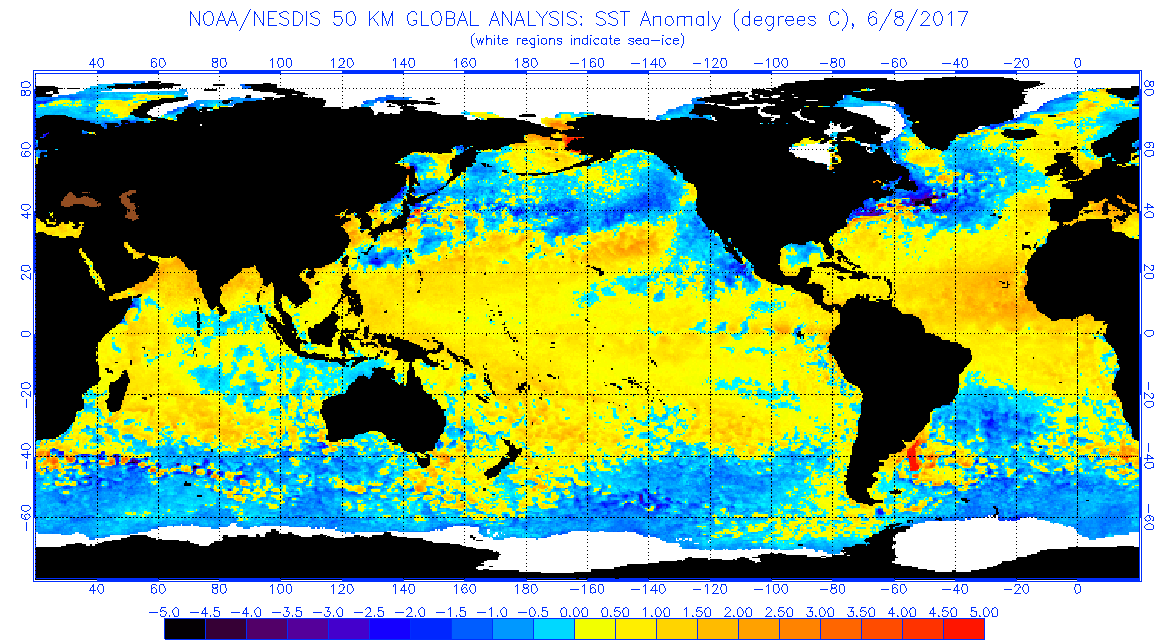
Just at a glance of the latest SST anomalies, it appears that there is an abundance of cool anomalies. Without a doubt there is warm water at the surface, but there isn't too much warm water to support this warmth, which is evident in the anomalies. Are there any years where there was an El-Nino that was completely surface-based? By what I have seen, 2002, 2006, and 2009 had a pretty warm subsurface. Maybe 2004 would fit this type of Nino?
0 likes
My posts are only my opinions and NOT official forecasts. For official forecasts, consult the National Hurricane Center or the National Weather Service.
Irene 11', Sandy 12', Fay 20’, Isaias 20’, Elsa 21’, Henri 21’, Ida 21’
Irene 11', Sandy 12', Fay 20’, Isaias 20’, Elsa 21’, Henri 21’, Ida 21’
-
Kingarabian
- S2K Supporter
- Posts: 15461
- Joined: Sat Aug 08, 2009 3:06 am
- Location: Honolulu, Hawaii
Re: ENSO Updates
weathaguyry wrote:Kingarabian wrote:weathaguyry wrote:There are atmospheric signals that support El-Nino, no doubt about that, but the ocean is not responding, even if you get a strong WWB, there is no pool of above normal SST's to even push to the surface, only blotches of warm areas and cool areas. I would say warm-neutral is likely for the peak of the season (.2-.4 above average) which will not create an El-Nino pattern nor will it create a La-Nina pattern. The chance for an El-Nino still exists, but a low SOI value alone will not create an El-Nino
The latest subsurface frame looks pretty similar to the previous frames - warm and cold patches spots spread out. The anomalies near the surface have presisted to keep the SSTs above 0.5C, and that doesn't change in this latest frame.
A WWB will absolutely help the cause for an El Nino and can promote warming if it were to occur. The warm pool has looked lackluster all spring long yet we sit above +0.5C.
This event just completely differs from past events where we traditionally see a deep warm pool enforce warming. The shallow subsurface has done an immense job in enforcing an El Nino while the depth plays catch up.
No one knows for sure what'll happen since ENSO has been strange this year. But right now we're at weak Nino levels despite what appears to be negative factors.
Just at a glance of the latest SST anomalies, it appears that there is an abundance of cool anomalies. Without a doubt there is warm water at the surface, but there isn't too much warm water to support this warmth, which is evident in the anomalies. Are there any years where there was an El-Nino that was completely surface-based? By what I have seen, 2002, 2006, and 2009 had a pretty warm subsurface. Maybe 2004 would fit this type of Nino?
We haven't had too much warm near the surface since spring, yet the output remains the same. We're going to see patches of cool anomalies here and there, but the overall picture looks the same where all Enso regions have the look of a traditional weak El Nino. And there is a WWB east of 120W that'll promote warming ar Nino 3 and Nino 1+2.
I doubt that this will have any implications on the ATL hurricane season, for me it's just bizarre that ENSO is acting differently this year compared to years past.
1 likes
RIP Kobe Bryant
Re: ENSO Updates
Bizzare is right. The cold pools we have seen since spring in any other year you would have an incoming weak Nina, no such reading.
0 likes
The above post and any post by Ntxw is NOT an official forecast and should not be used as such. It is just the opinion of the poster and may or may not be backed by sound meteorological data. It is NOT endorsed by any professional institution including Storm2k. For official information, please refer to NWS products.
Help support Storm2K!
Help support Storm2K!
-
weathaguyry
- Category 5
- Posts: 1272
- Age: 21
- Joined: Wed Jun 15, 2016 5:16 am
- Location: Long Island, NY
Re: ENSO Updates
Kingarabian wrote:weathaguyry wrote:Kingarabian wrote:
The latest subsurface frame looks pretty similar to the previous frames - warm and cold patches spots spread out. The anomalies near the surface have presisted to keep the SSTs above 0.5C, and that doesn't change in this latest frame.
A WWB will absolutely help the cause for an El Nino and can promote warming if it were to occur. The warm pool has looked lackluster all spring long yet we sit above +0.5C.
This event just completely differs from past events where we traditionally see a deep warm pool enforce warming. The shallow subsurface has done an immense job in enforcing an El Nino while the depth plays catch up.
No one knows for sure what'll happen since ENSO has been strange this year. But right now we're at weak Nino levels despite what appears to be negative factors.
Just at a glance of the latest SST anomalies, it appears that there is an abundance of cool anomalies. Without a doubt there is warm water at the surface, but there isn't too much warm water to support this warmth, which is evident in the anomalies. Are there any years where there was an El-Nino that was completely surface-based? By what I have seen, 2002, 2006, and 2009 had a pretty warm subsurface. Maybe 2004 would fit this type of Nino?
We haven't had too much warm near the surface since spring, yet the output remains the same. We're going to see patches of cool anomalies here and there, but the overall picture looks the same where all Enso regions have the look of a traditional weak El Nino. And there is a WWB east of 120W that'll promote warming ar Nino 3 and Nino 1+2.
I doubt that this will have any implications on the ATL hurricane season, for me it's just bizarre that ENSO is acting differently this year compared to years past.
It looks like a weak Nino with a blue snake in the middle of it
0 likes
My posts are only my opinions and NOT official forecasts. For official forecasts, consult the National Hurricane Center or the National Weather Service.
Irene 11', Sandy 12', Fay 20’, Isaias 20’, Elsa 21’, Henri 21’, Ida 21’
Irene 11', Sandy 12', Fay 20’, Isaias 20’, Elsa 21’, Henri 21’, Ida 21’
Who is online
Users browsing this forum: Cpv17, ddad040, duilaslol, Emmett_Brown, Google Adsense [Bot], JayTX, LarryWx, skyline385, StormWeather, tropicana and 133 guests