ENSO Updates (2007 thru 2023)
Moderator: S2k Moderators
Forum rules
The posts in this forum are NOT official forecasts and should not be used as such. They are just the opinion of the poster and may or may not be backed by sound meteorological data. They are NOT endorsed by any professional institution or STORM2K. For official information, please refer to products from the National Hurricane Center and National Weather Service.
Re: ENSO Updates
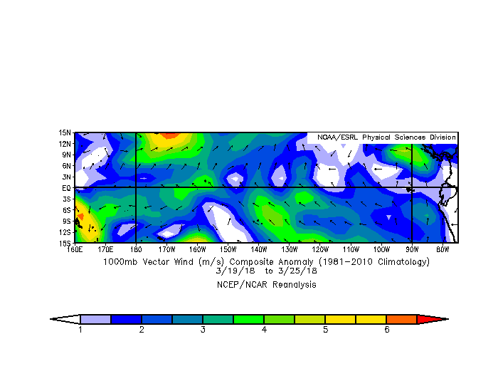
StruThiO wrote:https://i.imgur.com/WnmcNhD.png
doesn't seem too robust for a little while at least
That is actually quite robust in the WPAC! One must remember, the natural state (even without La Nina) is for trades to prevail in the tropical oceans. There are raw westerly component winds involved, it takes a lot to quell the trades completely and reverse it. What this has done and will do, so far, is push all that piled warm water in the WPAC slowly towards the dateline. In the coming months the warmth below the surface will strengthen as result.
As more WWBs (if they occur) will slowly push that water continuously eastward steadily. How far east is the money question. So while you're looking at reds and yellows, take a moment to think what is happening near and above the surface of the water. The momentum and wind stress is shoving the WPAC waters east.
3 likes
The above post and any post by Ntxw is NOT an official forecast and should not be used as such. It is just the opinion of the poster and may or may not be backed by sound meteorological data. It is NOT endorsed by any professional institution including Storm2k. For official information, please refer to NWS products.
- StruThiO
- Category 3
- Posts: 821
- Age: 24
- Joined: Fri Sep 15, 2017 5:51 am
- Location: Currently Portland, OR. Raised in Jax, FL.
Re: ENSO Updates
Ntxw wrote:
That is actually quite robust in the WPAC! One must remember, the natural state (even without La Nina) is for trades to prevail in the tropical oceans. There are raw westerly component winds involved, it takes a lot to quell the trades completely and reverse it. What this has done and will do, so far, is push all that piled warm water in the WPAC slowly towards the dateline. In the coming months the warmth below the surface will strengthen as result.
As more WWBs (if they occur) will slowly push that water continuously eastward steadily. How far east is the money question. So while you're looking at reds and yellows, take a moment to think what is happening near and above the surface of the water. The momentum and wind stress is shoving the WPAC waters east.
Hey, thanks for your reply! Always enjoy how informative they are . That makes sense. I just hope this all means the atlantic will go on vacation this year so people can finish rebuilding physically and emotionally.
1 likes
Re: ENSO Updates
StruThiO wrote:Ntxw wrote:
That is actually quite robust in the WPAC! One must remember, the natural state (even without La Nina) is for trades to prevail in the tropical oceans. There are raw westerly component winds involved, it takes a lot to quell the trades completely and reverse it. What this has done and will do, so far, is push all that piled warm water in the WPAC slowly towards the dateline. In the coming months the warmth below the surface will strengthen as result.
As more WWBs (if they occur) will slowly push that water continuously eastward steadily. How far east is the money question. So while you're looking at reds and yellows, take a moment to think what is happening near and above the surface of the water. The momentum and wind stress is shoving the WPAC waters east.
Hey, thanks for your reply! Always enjoy how informative they are . That makes sense. I just hope this all means the atlantic will go on vacation this year so people can finish rebuilding physically and emotionally.
Not a problem! ENSO is so fascinating to learn about. One of the best sources (besides the great released papers) is the ENSO blog from the CPC. One may not always agree with them, but they are some of the best in the field!
I learned well from 2009, 2012, 2014, 2015 events that when you get WWBs east of the dateline that's when you involve the stronger Ninos. Most Ninos you won't see it go that far east in context.
4 likes
The above post and any post by Ntxw is NOT an official forecast and should not be used as such. It is just the opinion of the poster and may or may not be backed by sound meteorological data. It is NOT endorsed by any professional institution including Storm2k. For official information, please refer to NWS products.
- Kingarabian
- S2K Supporter
- Posts: 15456
- Joined: Sat Aug 08, 2009 3:06 am
- Location: Honolulu, Hawaii
Re: ENSO Updates
StruThiO wrote:[img]https://i.imgur.com/WnmcNhD.png[img]
doesn't seem too robust for a little while at least
They yellow/red shades on the 29th of March near and over the dateline means that the trades will be very relaxed -- if the GFS is correct. That's important since the warm anomalies of the subsurface pool will have reached the surface by then, and there wont be any resistance from the trade winds to cool the anomalies. So we could see an immediate flip of the SSTs at Nino 3.4.
1 likes
RIP Kobe Bryant
- Kingarabian
- S2K Supporter
- Posts: 15456
- Joined: Sat Aug 08, 2009 3:06 am
- Location: Honolulu, Hawaii
Re: ENSO Updates
PDO signature for March seems to have taken on a cold/negative look.
1 likes
RIP Kobe Bryant
- Kingarabian
- S2K Supporter
- Posts: 15456
- Joined: Sat Aug 08, 2009 3:06 am
- Location: Honolulu, Hawaii
Re: ENSO Updates
.
The k/w has to go all the way across the pacific, it don't just put the brakes on when its under 3.4 and come to the surface. The trades have to push the warmed water in 1.2 back west back along the eq. Then you need to satisfy the thresholds and have atmosphere coupling.
As far as i know the ESPI is still in negative values over the enso region. No rain from
no convention.
The 850 zonal wind plot posted shows the easterlies are much stronger than the wwb.
Wwb needs to be well past 180w not to the west of it.
The season will officially begin on May 15 in the East Pacific Ocean and on June 1 in the Central Pacific; they will both end on November 30..... Maybe next year.
Happy to eat crow but don't think i will be
6 likes
- cycloneye
- Admin
- Posts: 139505
- Age: 67
- Joined: Thu Oct 10, 2002 10:54 am
- Location: San Juan, Puerto Rico
Re: ENSO Updates
Niño 1+2 is crashing.
1 likes
Visit the Caribbean-Central America Weather Thread where you can find at first post web cams,radars
and observations from Caribbean basin members Click Here
- Kingarabian
- S2K Supporter
- Posts: 15456
- Joined: Sat Aug 08, 2009 3:06 am
- Location: Honolulu, Hawaii
Re: ENSO Updates
Digital-TC-Chaser wrote:.
The k/w has to go all the way across the pacific, it don't just put the brakes on when its under 3.4 and come to the surface. The trades have to push the warmed water in 1.2 back west back along the eq. Then you need to satisfy the thresholds and have atmosphere coupling.
As far as i know the ESPI is still in negative values over the enso region. No rain from
no convention.
The 850 zonal wind plot posted shows the easterlies are much stronger than the wwb.
Wwb needs to be well past 180w not to the west of it.
The season will officially begin on May 15 in the East Pacific Ocean and on June 1 in the Central Pacific; they will both end on November 30..... Maybe next year.
Happy to eat crow but don't think i will be
Yes I agree with you in regards to the Kelvin wave, and if you look at the TAO buoys and the sub-surface analysis, you will see that the down welling Kelvin Wave continues to move east, and is creeping into Nino 3 and soon the Nino 1+2 regions.
In regards to the ESPI, I don't think we'll see sustained convection over the Nino regions until the SST's flip positive.
The reason why this WWB is important even though its west of the dateline, is because we have a legit downwelling Kelvin wave moving east, and the WWB will enhance the Kelvin wave even further.
Trades are naturally dominant over the equatorial pacific, so we will almost always have more winds moving east to west by default. Westerly winds simply halt the trades temporarily or for a period of time over a certain area and in regards to ENSO, they allow warm waters to surface. It's a phenomenon that we still know very little about. But when you see back to back WWB's like we've just seen, there is reason to believe that the atmosphere may be coupling with the ocean.
Of course if we don't have a WWB east of the dateline, then we'll likely see a warm-neutral ENSO at best for ASO. But in the upcoming months, there will be plenty of warm beneath the Nino regions, and all it will take is one WWB event to propel us into an El Nino.
4 likes
RIP Kobe Bryant
- cycloneye
- Admin
- Posts: 139505
- Age: 67
- Joined: Thu Oct 10, 2002 10:54 am
- Location: San Juan, Puerto Rico
Re: ENSO Updates
Interesting discussion in replies to tweet about the Indian Ocean / Pacific configuration resemble those in the 1980's.
https://twitter.com/akshaysampathk1/status/978119687379869696
https://twitter.com/_WxPhil_/status/978249468058447877
https://twitter.com/akshaysampathk1/status/978253688652251136
Replying to @_WxPhil_
Haha. But what's fascinating for me to see is SST in tropics over IO/PAC/Atlantic has El Nino'sh look. Don't they? But you're struggling to get that Warm Pool displacement from West Pac and get EHEM forcing going!
https://twitter.com/akshaysampathk1/status/978254118002163712
Replying to @_WxPhil_
In 1980's this configuration in tropics has resulted in El Nino. But seeing current behavior in tropics and from where we have come from 2015 super event, atmosphere coupling remains a question for this year's event!
2 likes
Visit the Caribbean-Central America Weather Thread where you can find at first post web cams,radars
and observations from Caribbean basin members Click Here
- cycloneye
- Admin
- Posts: 139505
- Age: 67
- Joined: Thu Oct 10, 2002 10:54 am
- Location: San Juan, Puerto Rico
Re: ENSO Updates
La Niña is still hanging on. CPC weekly update of 3/26/18 has Niño 3.4 is down to -0.8C.
http://www.cpc.noaa.gov/products/analys ... ts-web.pdf
3 likes
Visit the Caribbean-Central America Weather Thread where you can find at first post web cams,radars
and observations from Caribbean basin members Click Here
Re: ENSO Updates
Eastern ENSO regions have yet to reflect.
But west of the dateline the westerlies continues to expand. Of note the trades are shrinking in duration and intensity east of the dateline of late.
4 likes
The above post and any post by Ntxw is NOT an official forecast and should not be used as such. It is just the opinion of the poster and may or may not be backed by sound meteorological data. It is NOT endorsed by any professional institution including Storm2k. For official information, please refer to NWS products.
- Kingarabian
- S2K Supporter
- Posts: 15456
- Joined: Sat Aug 08, 2009 3:06 am
- Location: Honolulu, Hawaii
Re: ENSO Updates
Ntxw wrote:Eastern ENSO regions have yet to reflect.
But west of the dateline the westerlies continues to expand. Of note the trades are shrinking in duration and intensity east of the dateline of late.
[img]http://i64.tinypic.com/2rcx2s6.gif[img]
That's a large WWB. Even though the WWB has not reached east of the dateline, CDAS analysis shows weak westerly winds/significantly weaker trades stretching from 180-120W between 5S-5N.
We didn't see this type of wind activity at all last year.
2 likes
RIP Kobe Bryant
- NotSparta
- Professional-Met
- Posts: 1658
- Age: 22
- Joined: Fri Aug 18, 2017 8:24 am
- Location: Naples, FL
- Contact:
Re: ENSO Updates
Kingarabian wrote:Ntxw wrote:Eastern ENSO regions have yet to reflect.
But west of the dateline the westerlies continues to expand. Of note the trades are shrinking in duration and intensity east of the dateline of late.
[img]http://i64.tinypic.com/2rcx2s6.gif[img]
That's a large WWB. Even though the WWB has not reached east of the dateline, CDAS analysis shows weak westerly winds/significantly weaker trades stretching from 180-120W between 5S-5N.
We didn't see this type of wind activity at all last year.
The trades are still enhanced at the equator in that region, but yeah there are some decent westerly anomalies not too far to the north.
2 likes
This post was probably an opinion of mine, and in no way is official. Please refer to http://www.hurricanes.gov for official tropical analysis and advisories.
My website, with lots of tropical wx graphics, including satellite and recon: http://cyclonicwx.com
- cycloneye
- Admin
- Posts: 139505
- Age: 67
- Joined: Thu Oct 10, 2002 10:54 am
- Location: San Juan, Puerto Rico
Re: ENSO Updates
The latest update of the subsurface as of March 24 shows the cool waters trying to stop the warm pool so the battle rages on.
1 likes
Visit the Caribbean-Central America Weather Thread where you can find at first post web cams,radars
and observations from Caribbean basin members Click Here
- Kingarabian
- S2K Supporter
- Posts: 15456
- Joined: Sat Aug 08, 2009 3:06 am
- Location: Honolulu, Hawaii
Re: ENSO Updates
NotSparta wrote:Kingarabian wrote:Ntxw wrote:Eastern ENSO regions have yet to reflect.
But west of the dateline the westerlies continues to expand. Of note the trades are shrinking in duration and intensity east of the dateline of late.
[img]http://i64.tinypic.com/2rcx2s6.gif[img]
That's a large WWB. Even though the WWB has not reached east of the dateline, CDAS analysis shows weak westerly winds/significantly weaker trades stretching from 180-120W between 5S-5N.
[img]https://i.imgur.com/SlGGAsh.gif[img]
We didn't see this type of wind activity at all last year.
The trades are still enhanced at the equator in that region, but yeah there are some decent westerly anomalies not too far to the north.
[img]https://uploads.disquscdn.com/images/5e3d7d61fac17ed8d5342b7858be67b2030a028b4f2c2a25da335486b44d0332.gif[img]
That's true, we still need the winds at the equator to shift. But even with weak trades and no westerly winds, weak trades are also significant because surfacing warm anomalies will not be resisted as they normally would be. This happened last spring when weak warm anomalies allowed the Nino regions to be at borderline Nino levels due to weak trades.
This WWB has been strong enough to gradually affect the wind direction in the regions east of the dateline in the past few weeks. Let's see what April has in store.
4 likes
RIP Kobe Bryant
- NotSparta
- Professional-Met
- Posts: 1658
- Age: 22
- Joined: Fri Aug 18, 2017 8:24 am
- Location: Naples, FL
- Contact:
Re: ENSO Updates
Kingarabian wrote:NotSparta wrote:Kingarabian wrote:
That's a large WWB. Even though the WWB has not reached east of the dateline, CDAS analysis shows weak westerly winds/significantly weaker trades stretching from 180-120W between 5S-5N.
[img]https://i.imgur.com/SlGGAsh.gif[img]
We didn't see this type of wind activity at all last year.
The trades are still enhanced at the equator in that region, but yeah there are some decent westerly anomalies not too far to the north.
[img]https://uploads.disquscdn.com/images/5e3d7d61fac17ed8d5342b7858be67b2030a028b4f2c2a25da335486b44d0332.gif[img]
That's true, we still need the winds at the equator to shift. But even with weak trades and no westerly winds, weak trades are also significant because surfacing warm anomalies will not be resisted as they normally would be. This happened last spring when weak warm anomalies allowed the Nino regions to be at borderline Nino levels due to weak trades.
This WWB has been strong enough to gradually affect the wind direction in the regions east of the dateline in the past few weeks. Let's see what April has in store.
They're anomalies so they're stronger trades still at the equator and still easterlies northward, but some westerly anomalies are beginning to encroach on the main region which is pretty significant
1 likes
This post was probably an opinion of mine, and in no way is official. Please refer to http://www.hurricanes.gov for official tropical analysis and advisories.
My website, with lots of tropical wx graphics, including satellite and recon: http://cyclonicwx.com
- StruThiO
- Category 3
- Posts: 821
- Age: 24
- Joined: Fri Sep 15, 2017 5:51 am
- Location: Currently Portland, OR. Raised in Jax, FL.
Re: ENSO Updates
One things for sure, with la nina still managing to drop (as it went down to -0.8 this week), there really is barely any time at all for ENSO to be significantly detrimental to the upcoming hurricane season. I hope things change fast because I don't want an active season after last year. Question: I know Nino 1+2 is subject to more dramatic and quick fluctuations in temperature, but when it's sharply negative like it is currently (per tropicaltidbits) would that "slow" el Nino in any way? Thanks.
2 likes
Who is online
Users browsing this forum: 869MB, AnnularCane, cajungal, Google Adsense [Bot], skyline385, StPeteMike, Stratton23, Wampadawg and 50 guests