
2018 Tropics: Global Model Runs Discussion (Out to day 16)
Moderator: S2k Moderators
Forum rules

The posts in this forum are NOT official forecasts and should not be used as such. They are just the opinion of the poster and may or may not be backed by sound meteorological data. They are NOT endorsed by any professional institution or STORM2K. For official information, please refer to products from the National Hurricane Center and National Weather Service.
-
USTropics
- Category 5

- Posts: 2420
- Joined: Sun Aug 12, 2007 3:45 am
- Location: Florida State University
Re: 2018 Tropics: Global Model Runs Discussion (Out to day 16)
Here are the 180 hour forecasts for the last 5 ICON runs:
1 likes
Re: 2018 Tropics: Global Model Runs Discussion (Out to day 16)
GFS and CMC shifting west and weaker
Starting to come around to what I long suspected, a weak TS in the BOC
Starting to come around to what I long suspected, a weak TS in the BOC
3 likes
-
Haris

- Category 5
- Posts: 1808
- Joined: Mon Nov 27, 2017 8:19 pm
- Location: ( Bee Cave) West Austin, Texas
Re: 2018 Tropics: Global Model Runs Discussion (Out to day 16)
Alyono wrote:GFS and CMC shifting west and weaker
Starting to come around to what I long suspected, a weak TS in the BOC
TX rainmaker still?
1 likes
Weather geek and a storm spotter in West Austin. Not a degreed meteorologist. Big snow fan. Love rain and cold! Despise heat!
Re: 2018 Tropics: Global Model Runs Discussion (Out to day 16)
Haris wrote:Alyono wrote:GFS and CMC shifting west and weaker
Starting to come around to what I long suspected, a weak TS in the BOC
TX rainmaker still?
Possibly. This will probably be a broad system
1 likes

Re: 2018 Tropics: Global Model Runs Discussion (Out to day 16)
Alyono wrote:GFS and CMC shifting west and weaker
Starting to come around to what I long suspected, a weak TS in the BOC
I asked earlier, but are we discussing the same system that the GFS has been going crazy over?
0 likes
Personal Forecast Disclaimer:
The posts in this forum are NOT official forecast and should not be used as such. They are just the opinion of the poster and may or may not be backed by sound meteorological data. They are NOT endorsed by any professional institution or storm2k.org. For official information, please refer to the NHC and NWS products.
The posts in this forum are NOT official forecast and should not be used as such. They are just the opinion of the poster and may or may not be backed by sound meteorological data. They are NOT endorsed by any professional institution or storm2k.org. For official information, please refer to the NHC and NWS products.
-
Haris
- Category 5
- Posts: 1808
- Joined: Mon Nov 27, 2017 8:19 pm
- Location: ( Bee Cave) West Austin, Texas
Re: 2018 Tropics: Global Model Runs Discussion (Out to day 16)
SoupBone wrote:Alyono wrote:GFS and CMC shifting west and weaker
Starting to come around to what I long suspected, a weak TS in the BOC
I asked earlier, but are we discussing the same system that the GFS has been going crazy over?
yeah. 0z gfs STILL develops it. But the time just keeps getting pushed. CMC has DROPPED devlopment. Im not too confident but I dont lean GFS
0 likes
Weather geek and a storm spotter in West Austin. Not a degreed meteorologist. Big snow fan. Love rain and cold! Despise heat!
Re: 2018 Tropics: Global Model Runs Discussion (Out to day 16)
CMC still develops it
It just sends it into South Mexico
It just sends it into South Mexico
0 likes
-
Haris
- Category 5
- Posts: 1808
- Joined: Mon Nov 27, 2017 8:19 pm
- Location: ( Bee Cave) West Austin, Texas
Re: 2018 Tropics: Global Model Runs Discussion (Out to day 16)
Alyono wrote:CMC still develops it
It just sends it into South Mexico
gfs icon trended back E . CMC trended even more S and W.
Even more disagreement tonight. Wow
0 likes
Weather geek and a storm spotter in West Austin. Not a degreed meteorologist. Big snow fan. Love rain and cold! Despise heat!
-
Dylan

- Professional-Met

- Posts: 337
- Age: 29
- Joined: Mon May 31, 2010 9:50 am
- Location: New Orleans, LA
Re: 2018 Tropics: Global Model Runs Discussion (Out to day 16)
Looks like the GFS sends it into western Louisiana as a strong tropical storm. Depends on how strong the mid-level ridge is over the US, which the models have been over doing.
I’m not going to let one run of the Canadian of all models sway my opinion. 19/20 GFS Ensemble memebers had this in the previous run, that’s more important. Million dollar question is what does the European do?!?
I’m not going to let one run of the Canadian of all models sway my opinion. 19/20 GFS Ensemble memebers had this in the previous run, that’s more important. Million dollar question is what does the European do?!?
3 likes
Georges('98), Allison('01), Isidore('02), Lili('02), Frances('04) Ivan('04), Cindy('05), Katrina('05), Rita('05), Gustav('08), Isaac('12), Matthew('16), Harvey('17), Irma('17), Nate ('17), Ida ('21).
-
USTropics
- Category 5
- Posts: 2420
- Joined: Sun Aug 12, 2007 3:45 am
- Location: Florida State University
Re: 2018 Tropics: Global Model Runs Discussion (Out to day 16)
For the time being, I'll be tracking the tropical wave that just entered the eastern Caribbean as a possible seed for genesis. I've highlighted the tropical waves in the recent surface analysis, and highlighted the wave in the recent GFS run for the first 72 hours:


2 likes
-
stormreader
- Category 5
- Posts: 1242
- Joined: Fri Jun 24, 2011 10:58 am
Re: 2018 Tropics: Global Model Runs Discussion (Out to day 16)
USTropics wrote:For the time being, I'll be tracking the tropical wave that just entered the eastern Caribbean as a possible seed for genesis. I've highlighted the tropical waves in the recent surface analysis, and highlighted the wave in the recent GFS run for the first 72 hours:
https://i.imgur.com/UfhfERN.jpg
https://image.ibb.co/iwZJ7o/Webp_net_gifmaker_2.gif
Really interesting that we can't say where the energy is coming from for tropical genesis. I'm guessing (hoping) that an analysis of what the model portrays could give a description of atmospheric features contributing to tropical development. And I think some on this board could probably do that too. But still not really a fully definitive explanation of the cause of the feature that models are forecasting.
0 likes
-
USTropics
- Category 5
- Posts: 2420
- Joined: Sun Aug 12, 2007 3:45 am
- Location: Florida State University
Re: 2018 Tropics: Global Model Runs Discussion (Out to day 16)
MJO forecast shows the enhanced phase occurring right as our tropical wave enters the NW Caribbean (ascending westerly flow is normally seen on the eastern flank, which will provide plenty of low-level moisture convergence in the NW Caribbean):

1 likes
-
stormreader
- Category 5
- Posts: 1242
- Joined: Fri Jun 24, 2011 10:58 am
Re: 2018 Tropics: Global Model Runs Discussion (Out to day 16)
More interested than usual in the outcome of this situation forecast by many of the models. The fact that the Euro has been so late to forecast any kind of tropical genesis makes it more interesting. What intrigues me most of all is the fact that it is June, and among the mixed signals we have seen model forecasts for something major in the GOM. Experience tells us that a weak tropical storm is most likely in the offing. But it makes one wonder if this could be that unusual June situation where something more might occur. Not saying that's whats going to happen. Have to mention Audrey. It sort of came from nowhere. Not much info from that time......."Between June 20 and 25, 1957, an ill-defined tropical wave moved across the Caribbean Sea, over the Yucatán Peninsula, and into the Bay of Campeche. The system was difficult to trace until a report on June 24 from Carmen, Mexico, confirmed the presence of a low pressure area. So will be watching.
0 likes
-
Twisted-core
- Category 1

- Posts: 252
- Joined: Fri May 11, 2018 9:20 pm
Re: 2018 Tropics: Global Model Runs Discussion (Out to day 16)
Lot of sensible heat already in gomx. If that mjo plot verify's there will be a v/decent latent heat
flux increase coupled with excellent upper divergence over the region. As always shear maybe
the key player down the road.

flux increase coupled with excellent upper divergence over the region. As always shear maybe
the key player down the road.
1 likes
-
Kingarabian

- S2K Supporter

- Posts: 15451
- Joined: Sat Aug 08, 2009 3:06 am
- Location: Honolulu, Hawaii
Re: 2018 Tropics: Global Model Runs Discussion (Out to day 16)
Same song and dance on the 00z Euro.
0 likes
RIP Kobe Bryant
-
USTropics
- Category 5
- Posts: 2420
- Joined: Sun Aug 12, 2007 3:45 am
- Location: Florida State University
Re: 2018 Tropics: Global Model Runs Discussion (Out to day 16)
stormreader wrote:USTropics wrote:For the time being, I'll be tracking the tropical wave that just entered the eastern Caribbean as a possible seed for genesis. I've highlighted the tropical waves in the recent surface analysis, and highlighted the wave in the recent GFS run for the first 72 hours:
Really interesting that we can't say where the energy is coming from for tropical genesis. I'm guessing (hoping) that an analysis of what the model portrays could give a description of atmospheric features contributing to tropical development. And I think some on this board could probably do that too. But still not really a fully definitive explanation of the cause of the feature that models are forecasting.
Aric is the residential guru on tropical genesis, but I’ll briefly explain the general processes. In this particular instance, I believe tropical genesis (if it occurs) will spawn along the tropical wave axis. Tropical waves act as atmospheric troughs (elongated axis of low pressure that enhance Coriolis force).

The Caribbean has easterly flow from the trade winds (you can currently see this in the low-level wind flow):

As I mentioned in my MJO post above, the eastern flank of the enhanced phase of the MJO has westerly flow at the low levels. You can see this is creating convergence at the surface in the NW Caribbean currently:

Convergence at the surface enhanced by a trough (like our tropical wave), can create sufficient forcing to produce vorticity (Coriolis force). I.E. convergence at the surface enhanced by divergence aloft create ideal conditions for tropical formation:
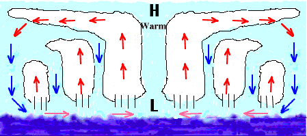
http://ww2010.atmos.uiuc.edu/(Gh)/guides/mtr/hyd/cond/cycl.rxml
We typically see tropical development as the tilt of our tropical wave changes in the NW Caribbean, enhancing forcing at the surface. Now that’s essentially a quick synopsis of our engine, with latent heat being our fuel (i.e. Sea Surface Temperatures):

of course, one major inhibiting factor currently is vertical wind shear:

Looking at the GFS shear anomaly chart, it would appear off the NE tip of the Yucatan towards the NGOM would provide a more favorable environment. This would explain why we see a weak vorticity reflection in the BOC on the 00z ECMWF run and a washed-out system impacting S Mexico on the 00z CMC.

That would also explain the center reformation on the 00z GFS/ICON runs near the NE tip of the Yucatan peninsula. A more eastern track (such as the GFS/ICON suggest) would be a much more favorable environment for intensification.
8 likes
-
StruThiO

- Category 3

- Posts: 821
- Age: 24
- Joined: Fri Sep 15, 2017 5:51 am
- Location: Currently Portland, OR. Raised in Jax, FL.
Re: 2018 Tropics: Global Model Runs Discussion (Out to day 16)
06z GFS taking a 981mb system into Texas coast near Houston
1 likes
-
Kingarabian
- S2K Supporter
- Posts: 15451
- Joined: Sat Aug 08, 2009 3:06 am
- Location: Honolulu, Hawaii

Re: 2018 Tropics: Global Model Runs Discussion (Out to day 16)
114 Hrs out.
Initialization over land, possibly from a MCS.

Initialization over land, possibly from a MCS.
1 likes
Re: 2018 Tropics: Global Model Runs Discussion (Out to day 16)
Model-to-model runs are showing improving conditions for intensification at CONUS landfall.
Particularly, mid-level moisture and 355K PV.


Particularly, mid-level moisture and 355K PV.
2 likes