ENSO Updates (2007 thru 2023)
Moderator: S2k Moderators
Forum rules

The posts in this forum are NOT official forecasts and should not be used as such. They are just the opinion of the poster and may or may not be backed by sound meteorological data. They are NOT endorsed by any professional institution or STORM2K. For official information, please refer to products from the National Hurricane Center and National Weather Service.
-
NotSparta

- Professional-Met

- Posts: 1658
- Age: 22
- Joined: Fri Aug 18, 2017 8:24 am
- Location: Naples, FL
- Contact:
Re: ENSO: ONI for JFM up to -0.8C
Other than SOI, are there any other indexes or ways to see how conductive the atmospheric conditions are for Niño development? Thanks 
0 likes
This post was probably an opinion of mine, and in no way is official. Please refer to http://www.hurricanes.gov for official tropical analysis and advisories.
My website, with lots of tropical wx graphics, including satellite and recon: http://cyclonicwx.com
My website, with lots of tropical wx graphics, including satellite and recon: http://cyclonicwx.com
-
Kingarabian

- S2K Supporter

- Posts: 15455
- Joined: Sat Aug 08, 2009 3:06 am
- Location: Honolulu, Hawaii
Re: ENSO: ONI for JFM up to -0.8C
CyclonicFury wrote:The current warm pool is impressive, but weaker than the warm pool of 2014 - which was nearly a failed El Nino. It took a secondary warm pool to initiate El Nino in 2014, and this was not until November. The current warm pool, as it spreads eastward and upward towards the surface, should be enough to dissipate the La Nina and turn ENSO neutral by May. We will need to watch if the warm pool weakens as it nears the surface. But it may take a second warm pool to start an El Nino, as well as a sustained period of westerly wind anomalies beginning in May/June. If the warm pool weakens as it reaches the surface and there isn't a second warm pool to follow it up, ENSO would probably stay neutral during this summer.
Out of curiosity, does anyone have any subsurface ENSO data at this time from 2006 and 2009, which were late-blooming El Ninos? I'm interested to see how they compare to this year.
Don't have the nice CPC animations to compare from 2006 and 2009.
2006 and 2018 comparison:

2009 and 2018 comparison:

3 likes
RIP Kobe Bryant
-
Kingarabian
- S2K Supporter
- Posts: 15455
- Joined: Sat Aug 08, 2009 3:06 am
- Location: Honolulu, Hawaii
Re: ENSO: ONI for JFM up to -0.8C
NotSparta wrote:Other than SOI, are there any other indexes or ways to see how conductive the atmospheric conditions are for Niño development? Thanks
SOI is your best bet, especially the 90 day SOI average. 30 day average has a lot of noise. Also speaking of the SOI, the last 3-4 daily readings seem to be off.
1 likes
RIP Kobe Bryant
-
NotSparta
- Professional-Met
- Posts: 1658
- Age: 22
- Joined: Fri Aug 18, 2017 8:24 am
- Location: Naples, FL
- Contact:
Re: ENSO: ONI for JFM up to -0.8C
After looking at reanalysis what did the 2006 La Niña in and turned things to cool neutral was this WWB. Doesn't look like the subsurface warm pool will be surfacing soon, so unless we get something like this soon, La Niña will probably stick around until mid-late April imo
1 likes
This post was probably an opinion of mine, and in no way is official. Please refer to http://www.hurricanes.gov for official tropical analysis and advisories.
My website, with lots of tropical wx graphics, including satellite and recon: http://cyclonicwx.com
My website, with lots of tropical wx graphics, including satellite and recon: http://cyclonicwx.com
-
StruThiO

- Category 3

- Posts: 821
- Age: 24
- Joined: Fri Sep 15, 2017 5:51 am
- Location: Currently Portland, OR. Raised in Jax, FL.
Re: ENSO: ONI for JFM up to -0.8C
One things for sure its insane how little of a handle we have on this when it affects so much globally especially hurricane season. While Kingarabian and others have brought up a good point about this upcoming May/June being so important especially because of 2006, 2009, it feels like we're starting to run against the clock as we enter April for ENSO to dramatically affect this upcoming tropical cyclone season for a certain basin.
The warm pool while strong seems to be meandering in place and the SOI is rather positive atm (again, I know these things can and will change). If you look at the OLR anomalies convection appears to continue to be suppressed along the pacific but enhanced in parts of the maritime continent. Overall the atmosphere seems biased towards la nina still. Again, with that warm pool we definitely have many pieces to the puzzle yet many are still missing to complete it. Unfortunately, all it seems we can do right now is continue to wait and see what happens (Argh!)
Disclaimer: this is just a total newbie's thoughts. I would like to thank this community for being so informative and friendly. This is all so fascinating to me.
The warm pool while strong seems to be meandering in place and the SOI is rather positive atm (again, I know these things can and will change). If you look at the OLR anomalies convection appears to continue to be suppressed along the pacific but enhanced in parts of the maritime continent. Overall the atmosphere seems biased towards la nina still. Again, with that warm pool we definitely have many pieces to the puzzle yet many are still missing to complete it. Unfortunately, all it seems we can do right now is continue to wait and see what happens (Argh!)
Disclaimer: this is just a total newbie's thoughts.
2 likes

Re: ENSO: ONI for JFM up to -0.8C
With ENSO sometimes it is better to step away from the ties to the hurricane/typhoon seasons. You can probably find some stat or info to fit the narrative and that's what can derail from the good stuff. Follow the buoys and readings from instruments and wind stress forecasts. That will go a much longer way.
The MJO is still cycling roughly 30 days or so. Much like the end of Feb, and end of March, the second half of April will likely yield another WWB. Nino 3.4 as in the name is tied to Nino 3 and Nino 4. Where those two head, 3.4 likely follows.
The MJO is still cycling roughly 30 days or so. Much like the end of Feb, and end of March, the second half of April will likely yield another WWB. Nino 3.4 as in the name is tied to Nino 3 and Nino 4. Where those two head, 3.4 likely follows.
2 likes
The above post and any post by Ntxw is NOT an official forecast and should not be used as such. It is just the opinion of the poster and may or may not be backed by sound meteorological data. It is NOT endorsed by any professional institution including Storm2k. For official information, please refer to NWS products.
Help support Storm2K!
-
StruThiO
- Category 3
- Posts: 821
- Age: 24
- Joined: Fri Sep 15, 2017 5:51 am
- Location: Currently Portland, OR. Raised in Jax, FL.
Re: ENSO: ONI for JFM up to -0.8C
What factors drives the MJO's amplitude? Looking at CPC's website, it mentions that the MJO is "quite variable with periods of moderate-to-strong activity followed by periods of little or no activity" and also that it is "most active during ENSO neutral years...absent during moderate-to-strong el nino and la nina events". OK, but why? Why does it have this natural variability? Is it absent during moderate/strong ENSO events because their affect on the atmosphere directly and destructively interferes with the MJO? Thanks, all
0 likes
Re: ENSO: ONI for JFM up to -0.8C
https://www.climate.gov/news-features/blogs/enso/what-mjo-and-why-do-we-care
In essence you can view the MJO as a shorter span of convective favor-ability in the terms of days and weeks. ENSO is a collection of this favor-ability in the span of months and seasons. This longer term smoothing dilutes or averages some effects of the MJO. During an El Nino the background forcing is in the Pacific, thus you will see an enhanced version of the MJO in the Pacific phases. During a La Nina that enhancement is over the Maritime continent, that is the basic black and white look with many gray areas to explain. Without the longer term effects of ENSO the MJO will appear to be moving at a good pace as it circles the globe without such background interference.
1 likes
The above post and any post by Ntxw is NOT an official forecast and should not be used as such. It is just the opinion of the poster and may or may not be backed by sound meteorological data. It is NOT endorsed by any professional institution including Storm2k. For official information, please refer to NWS products.
Help support Storm2K!
Help support Storm2K!
-
USTropics
- Category 5

- Posts: 2420
- Joined: Sun Aug 12, 2007 3:45 am
- Location: Florida State University
Re: ENSO: ONI for JFM up to -0.8C
StruThiO wrote::uarrow: Yeah, I don't like associating ENSO with that so much like i've done; it feels like a bastardization of ENSO in a certain way. I'm just worried about that, is all. Anyways. I have a question
What factors drives the MJO's amplitude? Looking at CPC's website, it mentions that the MJO is "quite variable with periods of moderate-to-strong activity followed by periods of little or no activity" and also that it is "most active during ENSO neutral years...absent during moderate-to-strong el nino and la nina events". OK, but why? Why does it have this natural variability? Is it absent during moderate/strong ENSO events because their affect on the atmosphere directly and destructively interferes with the MJO? Thanks, all
Although it specifically deals with the WNP basin, you can find most of the answers here (below is a pretty detailed excerpt too): https://journals.ametsoc.org/doi/abs/10 ... 11-00337.1
The asymmetric background modification by ENSO is found to greatly affect the extent of MJO modulation under different ENSO conditions. First, MJO activity is intensified and extends farther eastward during El Niño years, instead of being confined west of 150°E as in neutral and La Niña periods. Thus, the influence of MJO is stronger and more zonally widespread in El Niño years, causing significant differences in cyclogenesis parameters in most parts of the WNP. In El Niño years, cyclogenesis is further enhanced in the active phase due to synchronization of MJO signals with favorable background ENSO conditions. While in the inactive phase, the dominance of the strong MJO signals leads to further suppression in TC formation. This leads to overall enhancement of the MJO–TC relationship during El Niño years. On the other hand, the MJO signals confined to the western region west of 150°E in neutral and La Niña years lead to changes in TC-related parameters mainly in the western region, which contribute to the comparatively weaker TC modulations. It can thus be concluded that the MJO has an asymmetric modulation on cyclogenesis in the WNP under different ENSO conditions.
1 likes
-
Digital-TC-Chaser
Re: ENSO: ONI for JFM up to -0.8C
NotSparta wrote:Other than SOI, are there any other indexes or ways to see how conductive the atmospheric conditions are for Niño development? Thanks
ESPI is also a indicator of how the atmosphere is in enso.
https://trmm.gsfc.nasa.gov/trmm_rain/Ev ... y_day.html
1 likes
-
CyclonicFury

- Category 5
- Posts: 1977
- Age: 25
- Joined: Sun Jul 02, 2017 12:32 pm
- Location: NC
- Contact:
Re: ENSO: ONI for JFM up to -0.8C
Kingarabian wrote:CyclonicFury wrote:The current warm pool is impressive, but weaker than the warm pool of 2014 - which was nearly a failed El Nino. It took a secondary warm pool to initiate El Nino in 2014, and this was not until November. The current warm pool, as it spreads eastward and upward towards the surface, should be enough to dissipate the La Nina and turn ENSO neutral by May. We will need to watch if the warm pool weakens as it nears the surface. But it may take a second warm pool to start an El Nino, as well as a sustained period of westerly wind anomalies beginning in May/June. If the warm pool weakens as it reaches the surface and there isn't a second warm pool to follow it up, ENSO would probably stay neutral during this summer.
Out of curiosity, does anyone have any subsurface ENSO data at this time from 2006 and 2009, which were late-blooming El Ninos? I'm interested to see how they compare to this year.
Don't have the nice CPC animations to compare from 2006 and 2009.
2006 and 2018 comparison:
2009 and 2018 comparison:
Thanks. 2009 warm pool looks stronger than this year, but 2006 looks weaker.
1 likes
NCSU B.S. in Meteorology Class of 2021. Tropical weather blogger at http://www.cyclonicfury.com. My forecasts and thoughts are NOT official, for official forecasts please consult the National Hurricane Center.
-
NotSparta
- Professional-Met
- Posts: 1658
- Age: 22
- Joined: Fri Aug 18, 2017 8:24 am
- Location: Naples, FL
- Contact:
Re: ENSO: ONI for JFM up to -0.8C
CyclonicFury wrote:Kingarabian wrote:CyclonicFury wrote:The current warm pool is impressive, but weaker than the warm pool of 2014 - which was nearly a failed El Nino. It took a secondary warm pool to initiate El Nino in 2014, and this was not until November. The current warm pool, as it spreads eastward and upward towards the surface, should be enough to dissipate the La Nina and turn ENSO neutral by May. We will need to watch if the warm pool weakens as it nears the surface. But it may take a second warm pool to start an El Nino, as well as a sustained period of westerly wind anomalies beginning in May/June. If the warm pool weakens as it reaches the surface and there isn't a second warm pool to follow it up, ENSO would probably stay neutral during this summer.
Out of curiosity, does anyone have any subsurface ENSO data at this time from 2006 and 2009, which were late-blooming El Ninos? I'm interested to see how they compare to this year.
Don't have the nice CPC animations to compare from 2006 and 2009.
2006 and 2018 comparison:
2009 and 2018 comparison:
Thanks. 2009 warm pool looks stronger than this year, but 2006 looks weaker.
A big part of 2006's transition was a bunch of WWBs, not so much warm pools afaik
0 likes
This post was probably an opinion of mine, and in no way is official. Please refer to http://www.hurricanes.gov for official tropical analysis and advisories.
My website, with lots of tropical wx graphics, including satellite and recon: http://cyclonicwx.com
My website, with lots of tropical wx graphics, including satellite and recon: http://cyclonicwx.com
-
NotSparta
- Professional-Met
- Posts: 1658
- Age: 22
- Joined: Fri Aug 18, 2017 8:24 am
- Location: Naples, FL
- Contact:
Re: ENSO: ONI for JFM up to -0.8C
StruThiO wrote:NCDC PDO went from -0.17 for Feb to -0.51 in March.
The positive streak ended?
0 likes
This post was probably an opinion of mine, and in no way is official. Please refer to http://www.hurricanes.gov for official tropical analysis and advisories.
My website, with lots of tropical wx graphics, including satellite and recon: http://cyclonicwx.com
My website, with lots of tropical wx graphics, including satellite and recon: http://cyclonicwx.com
-
StruThiO
- Category 3
- Posts: 821
- Age: 24
- Joined: Fri Sep 15, 2017 5:51 am
- Location: Currently Portland, OR. Raised in Jax, FL.
Re: ENSO: ONI for JFM up to -0.8C
NotSparta wrote:StruThiO wrote:NCDC PDO went from -0.17 for Feb to -0.51 in March.
The positive streak ended?
Jisao is the one with the positive streak I think. Their value takes a while to come out it seems
2 likes
-
cycloneye

- Admin

- Posts: 139498
- Age: 67
- Joined: Thu Oct 10, 2002 10:54 am
- Location: San Juan, Puerto Rico
ENSO: ONI for JFM up to -0.8C / Coming up on April 12 (CPC complete update / CPC ENSO Blog Discussion)
The next CPC ENSO Diagnostic complete update that is issued every month on the second Thursdays (April 12) should give us plenty of information and we will see if El Niño Watch is issued.The March update had El Niño chance for ASO at 33%.Also,on that date,CPC ENSO BLOG will have the discussion about their thinking on why they did what the update says.
1 likes
Visit the Caribbean-Central America Weather Thread where you can find at first post web cams,radars
and observations from Caribbean basin members Click Here
and observations from Caribbean basin members Click Here
-
Kingarabian
- S2K Supporter
- Posts: 15455
- Joined: Sat Aug 08, 2009 3:06 am
- Location: Honolulu, Hawaii
Re: ENSO: ONI for JFM up to -0.8C / Coming up on April 12 (CPC Diagnostic update / CPC ENSO Blog Discussion)
As some of us on here have been saying, developments in March have disturbed the atmospheres La Nina base state and currently resulted into a shift back to neutral.
https://twitter.com/MJVentrice/status/981635039699132418
https://twitter.com/MJVentrice/status/981635039699132418
4 likes
RIP Kobe Bryant
-
Kingarabian
- S2K Supporter
- Posts: 15455
- Joined: Sat Aug 08, 2009 3:06 am
- Location: Honolulu, Hawaii
Re: ENSO: ONI for JFM up to -0.8C / Coming up on April 12 (CPC Diagnostic update / CPC ENSO Blog Discussion)
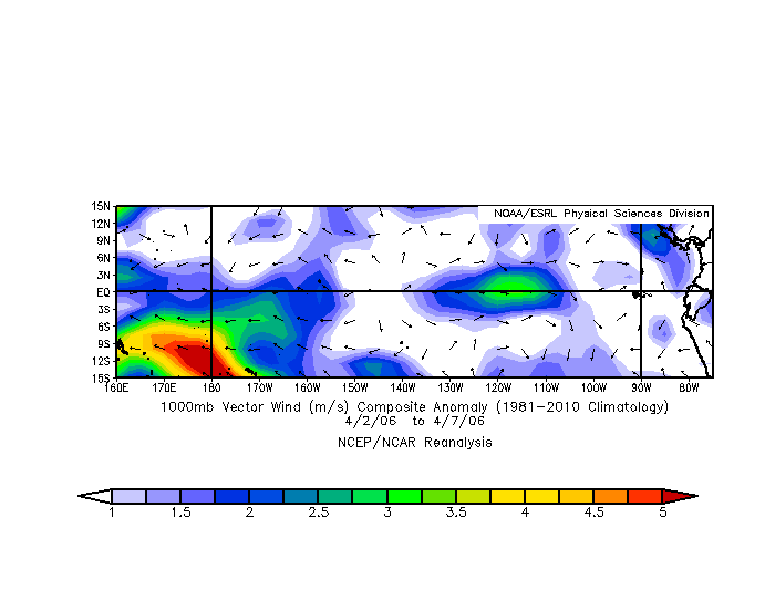
CDAS 850mb wind analysis continues to show deepening westerly wind anomalies across the eastern pacific basin:

2 likes
RIP Kobe Bryant
-
Kingarabian
- S2K Supporter
- Posts: 15455
- Joined: Sat Aug 08, 2009 3:06 am
- Location: Honolulu, Hawaii
Re: ENSO: ONI for JFM up to -0.8C / Coming up on April 12 (CPC Diagnostic update / CPC ENSO Blog Discussion)
For future purposes, looking @ 150E-160E at 100-150 meters. Keeping eye there, as another down welling Kelvin wave may have been triggered due the strong March WWB. We can also see this development on the TAO buoys.

Edit: Also looks like an upwelling Kelvin wave developing there at the same time. Not on the buoys yet.
Edit: Also looks like an upwelling Kelvin wave developing there at the same time. Not on the buoys yet.
3 likes
RIP Kobe Bryant
-
Digital-TC-Chaser
Re: ENSO: ONI for JFM up to -0.8C / Coming up on April 12 (CPC Diagnostic update / CPC ENSO Blog Discussion)
Email Service emailservice stormvistawx
date: Wed, Apr 4, 2018 at 9:15 PM
subject: ENSO/SST Tracker (04/03/2018)

https://imgur.com/ppsfu1A

https://imgur.com/OnjIO5a
kw wiping out whats left of nina as expected by models.
........................................................................................................
Edit added later.
As for a new k/w ? http://www.stormsurfing.com/cgi/display ... ?a=wwb_slp
not seeing that myself.
KW
https://imgur.com/hNQSJDl
mjo
https://imgur.com/3P9aqiR
date: Wed, Apr 4, 2018 at 9:15 PM
subject: ENSO/SST Tracker (04/03/2018)
https://imgur.com/ppsfu1A
https://imgur.com/OnjIO5a
kw wiping out whats left of nina as expected by models.
........................................................................................................
Edit added later.
As for a new k/w ? http://www.stormsurfing.com/cgi/display ... ?a=wwb_slp
not seeing that myself.
KW
https://imgur.com/hNQSJDl
mjo
https://imgur.com/3P9aqiR
2 likes
Who is online
Users browsing this forum: caneman, Cpv17, Google [Bot], HurricaneBelle, Ivanhater, Lizzytiz1, Stratton23, TheWisestofAll and 57 guests