
Here are Typhoon Tip images I found. Look at between 277 to 292 and click GMS-1.
ftp://eclipse.ncdc.noaa.gov/pub/isccp/b ... ages/1979/
Tip was at her peak on October 12, 1979, which is 285.
Here is the link of Tip at her peak Tip.
ftp://eclipse.ncdc.noaa.gov/pub/isccp/b ... S-1-IR.jpg
ftp://eclipse.ncdc.noaa.gov/pub/isccp/b ... S-1-IR.jpg
ftp://eclipse.ncdc.noaa.gov/pub/isccp/b ... S-1-IR.jpg
ftp://eclipse.ncdc.noaa.gov/pub/isccp/b ... S-1-IR.jpg
A link of Tip on October 14.
ftp://eclipse.ncdc.noaa.gov/pub/isccp/b ... S-1-IR.jpg
A really large storm. It almost touches the equator. It stretches from 30 degrees North to the equator, while it is stretching from 120 to 150 degrees longitude east.
Typhoon Tip Satellite Image
Moderator: S2k Moderators
Forum rules

The posts in this forum are NOT official forecasts and should not be used as such. They are just the opinion of the poster and may or may not be backed by sound meteorological data. They are NOT endorsed by any professional institution or STORM2K. For official information, please refer to products from the National Hurricane Center and National Weather Service.
Typhoon Tip Satellite Image
0 likes
-
HurricaneBill
- Category 5

- Posts: 3419
- Joined: Sun Apr 11, 2004 5:51 pm
- Location: East Longmeadow, MA, USA
Re: Typhoon Tip Satellite Image
Ptarmigan wrote:
Tip was at her peak on October 12, 1979, which is 285.
Tip was a "he".
0 likes
-
Category 5

- Category 5
- Posts: 10074
- Age: 36
- Joined: Sun Feb 11, 2007 10:00 pm
- Location: New Brunswick, NJ
- Contact:
Re: Typhoon Tip Satellite Image
The images I've been looking for! You are my hero!
I will be honest, not as big as I thought.
I will be honest, not as big as I thought.
0 likes
-
HurricaneBill
- Category 5
- Posts: 3419
- Joined: Sun Apr 11, 2004 5:51 pm
- Location: East Longmeadow, MA, USA

Re: Typhoon Tip Satellite Image
Category 5 wrote:The images I've been looking for! You are my hero!
I will be honest, not as big as I thought.
It looks large to me. I even compared it with Gilbert, Floyd, Katrina, and Wilma and they are small compared to Tip.
0 likes

-
AnnularCane

- S2K Supporter

- Posts: 2959
- Joined: Thu Jun 08, 2006 9:18 am
- Location: Wytheville, VA
Re:
Cyclenall wrote:I've been trying to find those too, they weren't there when I looked last time. This is great.
At peak strength, it looks big but not amazingly large. But the last link in the OP's first post had Tip when it was starting to weaken and it looked like a monster!!
Yeah, I noticed that too. I think when it weakened, that's when it made its record as being the largest tropical cyclone.
0 likes
-
HurricaneRobert
- Category 3

- Posts: 812
- Joined: Fri May 18, 2007 9:31 pm

-
Ed Mahmoud
Re: Typhoon Tip Satellite Image
What was the other storm in the South China Sea? It looked like a pretty big storm, but nothing compared to Tip.
0 likes
Re: Typhoon Tip Satellite Image
Ed Mahmoud wrote:What was the other storm in the South China Sea? It looked like a pretty big storm, but nothing compared to Tip.
Typhoon Sarah.
0 likes
-
whereverwx
- Category 5
- Posts: 1107
- Joined: Mon May 31, 2004 10:15 pm
It would probably make more sense to compare the size of Tip with the Atlantic, as we are more familiar with systems from that basin. The Northwestern Pacific is large enough to make massive typhoons appear small.
Here are two poorly superimposed images of Tip in the Atlantic:
Image
Image
Here are two poorly superimposed images of Tip in the Atlantic:
Image
Image
Last edited by whereverwx on Wed Jul 30, 2008 7:53 pm, edited 1 time in total.
0 likes
Re: Typhoon Tip Satellite Image
Finally a Gibbs image of Tip!
I gotta say, not AS big as I expected...
Definitely bigger than any Atlantic storm I've seen, but not necessarilly all WPAC storms.
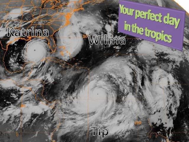
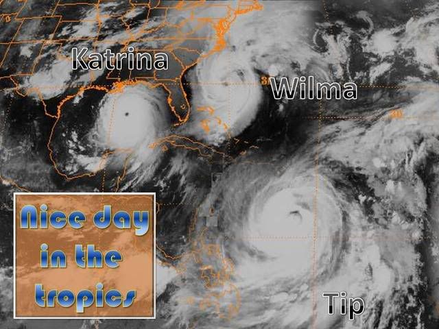
For your comparison... 2 big Atlantic hurricanes (Kat and Wilma) and 2 big WPAC typhoons (Tip and Nabi)
All images have the same resolution.


Still, huge.
I gotta say, not AS big as I expected...
Definitely bigger than any Atlantic storm I've seen, but not necessarilly all WPAC storms.
For your comparison... 2 big Atlantic hurricanes (Kat and Wilma) and 2 big WPAC typhoons (Tip and Nabi)
All images have the same resolution.
Still, huge.
0 likes
Re: Typhoon Tip Satellite Image
Good comparison Cyclone1. I believe size is based on circulation and extent of gale force winds, not cloud base. The cloud base is not as large as one would expect.
Whereverwx, Tip at his peak looks a little larger than Gilbert. However, two days later, it is larger, covering almost all of the Caribbean and Central America. It even stretches into the Pacific.
Whereverwx, Tip at his peak looks a little larger than Gilbert. However, two days later, it is larger, covering almost all of the Caribbean and Central America. It even stretches into the Pacific.
0 likes


-
Category 5
- Category 5
- Posts: 10074
- Age: 36
- Joined: Sun Feb 11, 2007 10:00 pm
- Location: New Brunswick, NJ
- Contact:
Re: Re:
Ptarmigan wrote:Cyclenall wrote:I've been trying to find those too, they weren't there when I looked last time. This is great.
At peak strength, it looks big but not amazingly large. But the last link in the OP's first post had Tip when it was starting to weaken and it looked like a monster!!
Yeah, I noticed that too. I think when it weakened, that's when it made its record as being the largest tropical cyclone.
Yes, as it went through an EWRC.
0 likes
-
Category 5
- Category 5
- Posts: 10074
- Age: 36
- Joined: Sun Feb 11, 2007 10:00 pm
- Location: New Brunswick, NJ
- Contact:
Re:
HURAKAN wrote:
Could you use the first Tip Image from 10/14? Thats when it was about its biggest.
0 likes
-
HurricaneRobert
- Category 3
- Posts: 812
- Joined: Fri May 18, 2007 9:31 pm