
From my research, Maritime Continent is "the region of Southeast Asia which comprises many islands, peninsulas and shallow seas" (Wikipedia), not an atmospheric condition or time of the year. So, I'm trying to understand your sentence, without success.Ntxw wrote:TropicalAnalystwx13 wrote:The MJO still has a profound positive influence over Africa during octants 2/3. It's not really until 4-5 when it starts to become unfavorable.
Correct, which is why in my post I stated Maritime Continent is when Africa starts getting dry (phases 4-5) not the Indian Ocean phases (2+3) conflicting with the idea of IO convection (rising air) creating subsidence in Africa that you mentioned in the previous post.
Atlantic Sea Surface Temperatures and Anomalies
Moderator: S2k Moderators
Forum rules

The posts in this forum are NOT official forecasts and should not be used as such. They are just the opinion of the poster and may or may not be backed by sound meteorological data. They are NOT endorsed by any professional institution or STORM2K. For official information, please refer to products from the National Hurricane Center and National Weather Service.
Re: Re:

0 likes

Re: Re:
abajan wrote:From my research, Maritime Continent is "the region of Southeast Asia which comprises many islands, peninsulas and shallow seas" (Wikipedia), not an atmospheric condition or time of the year. So, I'm trying to understand your sentence, without success.Ntxw wrote:TropicalAnalystwx13 wrote:The MJO still has a profound positive influence over Africa during octants 2/3. It's not really until 4-5 when it starts to become unfavorable.
Correct, which is why in my post I stated Maritime Continent is when Africa starts getting dry (phases 4-5) not the Indian Ocean phases (2+3) conflicting with the idea of IO convection (rising air) creating subsidence in Africa that you mentioned in the previous post.
Discussion was about where convection creates subsidence in Africa which begins once it reaches the Maritime Continent vs over in the IO
0 likes
The above post and any post by Ntxw is NOT an official forecast and should not be used as such. It is just the opinion of the poster and may or may not be backed by sound meteorological data. It is NOT endorsed by any professional institution including Storm2k. For official information, please refer to NWS products.
Help support Storm2K!
-
gatorcane

- S2K Supporter

- Posts: 23499
- Age: 46
- Joined: Sun Mar 13, 2005 3:54 pm
- Location: Boca Raton, FL
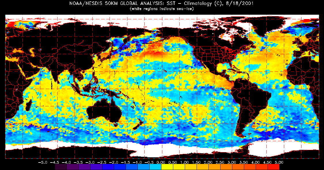
Going back and looking at SST anomalies in the EPAC and Atlantic basins around this date for the past 17 years, I could find two years where anomalies look very similar to this year: 1996 and 2001.
Not sure if this will mean anything as far as how this season turns out but thought it was interesting how close those two years were to this current year; 1996 even had an early Cape Verde system (Bertha) like we had this year.
Current global anomalies:

1996 global anomalies:
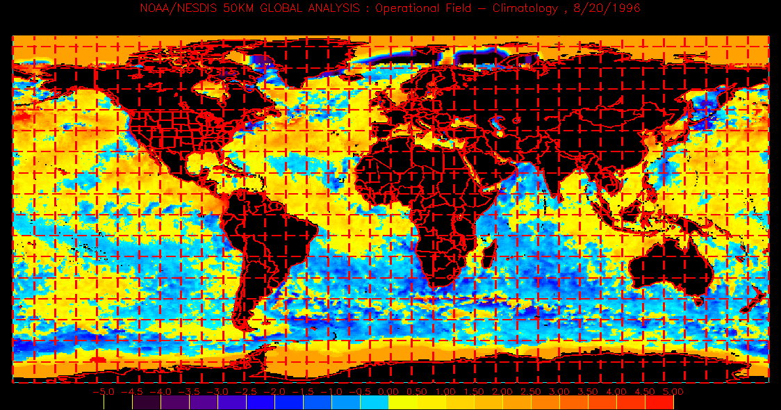
2001 global anomalies:
Not sure if this will mean anything as far as how this season turns out but thought it was interesting how close those two years were to this current year; 1996 even had an early Cape Verde system (Bertha) like we had this year.
Current global anomalies:
1996 global anomalies:
2001 global anomalies:
0 likes

2001 looks like it would be a better comparison given the point about the Indian Ocean waters being warmer. It sort of fits as well as 2001 had no hurricanes until Sep 9-10 and only four tropical storms before September (interestingly, like this year, the first two were in the gulf and the second two were in the deep tropics.)
0 likes
The above post is not official and should not be used as such. It is the opinion of the poster and may or may not be backed by sound meteorological data. It is not endorsed by any professional institution or storm2k.org. For official information, please refer to the NHC and NWS products.
-
Hybridstorm_November2001

- S2K Supporter
- Posts: 2802
- Joined: Sat Aug 21, 2004 2:50 pm
- Location: SW New Brunswick, Canada
- Contact:
Re:
Hammy wrote:2001 looks like it would be a better comparison given the point about the Indian Ocean waters being warmer. It sort of fits as well as 2001 had no hurricanes until Sep 9-10 and only four tropical storms before September (interestingly, like this year, the first two were in the gulf and the second two were in the deep tropics.)
I sure as heck hope not. 2001 gave us the hybridstorm (a combination of Hurricane Michelle, TS Noel & a Short Wave from New England) that produced one of our worst wind storms in 20 years. Average 50 mph sustained and peak gusts to 85 mph in my area alone for over 12hr! Damn, other than Andrew in South Florida back in 1992, it was the most frightening wind event I was ever through. I certainly hope something like that never happens again during my life.
0 likes

Re: Re:
Hybridstorm_November2001 wrote:I sure as heck hope not. 2001 gave us the hybridstorm (a combination of Hurricane Michelle, TS Noel & a Short Wave from New England) that produced one of our worst wind storms in 20 years. Average 50 mph sustained and peak gusts to 85 mph in my area alone for over 12hr! Damn, other than Andrew in South Florida back in 1992, it was the most frightening wind event I was ever through. I certainly hope something like that never happens again during my life.
I've been wanting a windstorm in my region for what seems like forever. We never get them, I bet its been at least 100 years since a legit one roared through. I thought Sandy would be the "one" but it wasn't to my shock. If you get one again, lets switch places
0 likes
-
Hybridstorm_November2001
- S2K Supporter
- Posts: 2802
- Joined: Sat Aug 21, 2004 2:50 pm
- Location: SW New Brunswick, Canada
- Contact:
Re: Re:
Cyclenall wrote:Hybridstorm_November2001 wrote:I sure as heck hope not. 2001 gave us the hybridstorm (a combination of Hurricane Michelle, TS Noel & a Short Wave from New England) that produced one of our worst wind storms in 20 years. Average 50 mph sustained and peak gusts to 85 mph in my area alone for over 12hr! Damn, other than Andrew in South Florida back in 1992, it was the most frightening wind event I was ever through. I certainly hope something like that never happens again during my life.
I've been wanting a windstorm in my region for what seems like forever. We never get them, I bet its been at least 100 years since a legit one roared through. I thought Sandy would be the "one" but it wasn't to my shock. If you get one again, lets switch places.
Well we get them rather often here, once a decade or more. We had one in 2011 (Irene remnants), 2001 very bad one, 1996 (Bertha remnants), 1995 two bad ones, two in 1994 one bad and the other very bad, 1993 (Superstorm), 1991 (Bob remnants), 1987 bad one, 1985 very bad one (Gloria remnants) that is about it for my lifetime.
0 likes


Re: Atlantic Sea Surface Temperatures and Anomalies
Interesting article regarding a flight mission made today by NOAA's Hurricane Research Division. They are interested in a cold area of water just northeast of the Yucatan.
http://noaahrd.wordpress.com/2013/08/20/hurricane-field-program-update-tuesday-august-20-2013-924-am-eastern/
http://noaahrd.wordpress.com/2013/08/20/hurricane-field-program-update-tuesday-august-20-2013-924-am-eastern/
0 likes
The following post is NOT an official forecast and should not be used as such. It is just the opinion of the poster and may or may not be backed by sound meteorological data. It is NOT endorsed by storm2k.org.
-
'CaneFreak

- Category 5

- Posts: 1475
- Joined: Mon Jun 05, 2006 10:50 am
- Location: New Bern, NC

-
ninel conde
- Category 5
- Posts: 1245
- Joined: Mon Aug 04, 2008 2:18 pm
Re:
'CaneFreak wrote:Impressive
Notice how high the potential maximum wind is off the Southeastern US coast. Also, take note of how low the potential minimum pressure values are off the east coast. This basically means the Western Atlantic basin can now support a category 5 hurricane.
http://img593.imageshack.us/img593/3015/dtki.png
impressive if anything were to develop but with a very persistent nw flow across the east coast and west atlantic it's probably going to be unused potential. certainly the pattern does not favor any close in development and nothing is developing further out.
0 likes
The posts in this forum are NOT official forecast and should not be used as such. They are just the opinion of the poster and may or may not be backed by sound meteorological data. They are NOT endorsed by any professional institution or storm2k.org. For official information, please refer to the NHC and NWS products.
-
cycloneye

- Admin

- Posts: 139071
- Age: 67
- Joined: Thu Oct 10, 2002 10:54 am
- Location: San Juan, Puerto Rico
Re: Atlantic Sea Surface Temperatures and Anomalies
So far the Atlantic waters in 2014 are a little bit cooler than in 2013. Only the sst anomalies are warmer in Western Atlantic in 2014 than in 2013.
2013.

2014

2013

2014

2013

2014

2013.

2014.

2013.
2014
2013
2014
2013
2014
2013.
2014.
0 likes
Visit the Caribbean-Central America Weather Thread where you can find at first post web cams,radars
and observations from Caribbean basin members Click Here
and observations from Caribbean basin members Click Here
-
TropicalAnalystwx13

- Category 5
- Posts: 2109
- Age: 26
- Joined: Tue Jul 19, 2011 8:20 pm
- Location: Wilmington, NC
- Contact:
East Atlantic sea surface temperatures are not doing well right now. A very strong Azores high has accelerated trade winds across the region, leading to evaporational cooling. It doesn't look like this pattern will reverse anytime soon.
In other news, check out how warm sea surface temperatures are off the East Coast!

In other news, check out how warm sea surface temperatures are off the East Coast!
0 likes
-
Hurricaneman

- Category 5
- Posts: 7281
- Age: 43
- Joined: Tue Aug 31, 2004 3:24 pm
- Location: central florida
Could be quite the landfall season with this SSTA pattern whether we have El Nino or not
The posts in this forum are NOT official forecast and should not be used as such. They are just the opinion of the poster and may or may not be backed by sound meteorological data. They are NOT endorsed by any professional institution or storm2k.org. For official information, please refer to the NHC and NWS products
The posts in this forum are NOT official forecast and should not be used as such. They are just the opinion of the poster and may or may not be backed by sound meteorological data. They are NOT endorsed by any professional institution or storm2k.org. For official information, please refer to the NHC and NWS products
0 likes
-
cycloneye
- Admin
- Posts: 139071
- Age: 67
- Joined: Thu Oct 10, 2002 10:54 am
- Location: San Juan, Puerto Rico
Expert forecasts for 2014 N Atl season (See first post)
The sst anomalie analogs so far for 2014 are 2009 and 2012.

0 likes
Visit the Caribbean-Central America Weather Thread where you can find at first post web cams,radars
and observations from Caribbean basin members Click Here
and observations from Caribbean basin members Click Here

Re: Atlantic Sea Surface Temperatures and Anomalies
cycloneye wrote:The sst anomalie analogs so far for 2014 are 2009 and 2012.
http://oi59.tinypic.com/34s2hc5.jpg
That is a scary map to me. Look at those anomolies close to land and you can see the gulf loop current making a good showing. This year is going to surprise some folks. You are more likely to see development closer to the coast. There is a big difference between the previous El Nino years were there was nowhere near the warmth close to the coast.
Thanks for posting.
0 likes
The following post is NOT an official forecast and should not be used as such. It is just the opinion of the poster and may or may not be backed by sound meteorological data. It is NOT endorsed by any professional institution including storm2k.org For Official Information please refer to the NHC and NWS products.
Re: Atlantic Sea Surface Temperatures and Anomalies
blp wrote:cycloneye wrote:The sst anomalie analogs so far for 2014 are 2009 and 2012.
http://oi59.tinypic.com/34s2hc5.jpg
That is a scary map to me. Look at those anomolies close to land and you can see the gulf loop current making a good showing. This year is going to surprise some folks. You are more likely to see development closer to the coast. There is a big difference between the previous El Nino years were there was nowhere near the warmth close to the coast.
Thanks for posting.
One thing we need to consider that people often overlook. It's true that if something forms there will be lots of fuel (there always is by late summer) but that warmer waters also produce higher pressures. Remember all the warm water in the central North Atlantic last year? Big Bermuda high just dominated. So while yes warmer waters is good fuel, cooler waters is where lower pressures tend to be for storm formation. Even if it is cool, cool is a relative to average so it can still fuel them with lower pressures.
0 likes
The above post and any post by Ntxw is NOT an official forecast and should not be used as such. It is just the opinion of the poster and may or may not be backed by sound meteorological data. It is NOT endorsed by any professional institution including Storm2k. For official information, please refer to NWS products.
Help support Storm2K!
Help support Storm2K!
-
MGC

- S2K Supporter
- Posts: 5792
- Joined: Sun Mar 23, 2003 9:05 pm
- Location: Pass Christian MS, or what is left.
Re: Atlantic Sea Surface Temperatures and Anomalies
Looks like some serious upwelling off the coast of Africa. Might put a dent in the CV season. But, I think enhanced upper air winds and dry air from Africa will be the big players this season.....MGC
0 likes
-
TropicalAnalystwx13
- Category 5
- Posts: 2109
- Age: 26
- Joined: Tue Jul 19, 2011 8:20 pm
- Location: Wilmington, NC
- Contact:
Re: Atlantic Sea Surface Temperatures and Anomalies
Ntxw wrote:blp wrote:cycloneye wrote:The sst anomalie analogs so far for 2014 are 2009 and 2012.
http://oi59.tinypic.com/34s2hc5.jpg
That is a scary map to me. Look at those anomolies close to land and you can see the gulf loop current making a good showing. This year is going to surprise some folks. You are more likely to see development closer to the coast. There is a big difference between the previous El Nino years were there was nowhere near the warmth close to the coast.
Thanks for posting.
One thing we need to consider that people often overlook. It's true that if something forms there will be lots of fuel (there always is by late summer) but that warmer waters also produce higher pressures. Remember all the warm water in the central North Atlantic last year? Big Bermuda high just dominated. So while yes warmer waters is good fuel, cooler waters is where lower pressures tend to be for storm formation. Even if it is cool, cool is a relative to average so it can still fuel them with lower pressures.
Eh, this isn't necessarily true, and it's easy to get confused with because I used to think the same until Levi32 (runs TropicalTidbits) explained it to me. I wish I could find the post. In general though, warm ocean temperatures warm the air above it. Because warm air is less dense, it rises and feedbacks with lower pressures at the surface. This makes sense if you think about a) the tropical Atlantic during active hurricane seasons and b) the subtropical Atlantic in 2012 (if warm water created high pressure, there would be no storms).
Here's a tweet from Eric Blake this morning hinting at the western Atlantic may be the sweet spot this year:
@TropicalTidbits 5h
@EricBlake12 Wonder how warm west Atl. waters can persist. Similar years w/ El Nino still had several home-brew storms, especially early.
@EricBlake12 5h
@TropicalTidbits Strong ridge east weaker ridge west usually promotes that pattern. Not many fronts in W Atlc either...
0 likes
Re: Atlantic Sea Surface Temperatures and Anomalies
TropicalAnalystwx13 wrote:Eh, this isn't necessarily true, and it's easy to get confused with because I used to think the same until Levi32 (runs TropicalTidbits) explained it to me. I wish I could find the post. In general though, warm ocean temperatures warm the air above it. Because warm air is less dense, it rises and feedbacks with lower pressures at the surface. This makes sense if you think about a) the tropical Atlantic during active hurricane seasons and b) the subtropical Atlantic in 2012 (if warm water created high pressure, there would be no storms).
Here's a tweet from Eric Blake this morning hinting at the western Atlantic may be the sweet spot this year:
@TropicalTidbits 5h
@EricBlake12 Wonder how warm west Atl. waters can persist. Similar years w/ El Nino still had several home-brew storms, especially early.
@EricBlake12 5h
@TropicalTidbits Strong ridge east weaker ridge west usually promotes that pattern. Not many fronts in W Atlc either...
Is this not how the PDO and AMO works? It's not just looking at the immediate surface. There is always higher and lower pressures in the atmosphere and from everything I've gathered warmer waters (relative to the reverse cooler waters) sets up ridges and troughs, thus higher and lower pressures. During the +AMO you see persistent ridges in warmer waters relative to normal in the far north Atlantic and lower pressures off the east coast (thus cooler waters) and lots of cyclone activity. The -AMO is the precise opposite. Cooler waters up north (relative to the warmer waters down south) promotes lower pressures in the far north Atlantic and high pressures to the south off the east coast.
And this is not looking at any individual period. You can always have systems on a small scale relative to everything else or MJO impulses lowering pressures below the ridges, but the theme is overall it tends to favor higher pressures as a whole in the season. Perhaps that is what the ECMWF has been portraying but we just don't like seeing it.
0 likes
The above post and any post by Ntxw is NOT an official forecast and should not be used as such. It is just the opinion of the poster and may or may not be backed by sound meteorological data. It is NOT endorsed by any professional institution including Storm2k. For official information, please refer to NWS products.
Help support Storm2K!
Help support Storm2K!

Re: Atlantic Sea Surface Temperatures and Anomalies
Would this be what helped the 2004 hurricane season. Looking back at dates and then sst for that time of year the entire atlantic appears to bo above normal temps. All the major hurricanes that hit florida formed in west atlantic and carribean in above average sst and thenrode up the carribean in above average sst. Was 2004 also not a weak nino year. Just looking back at that year their appears to be some simularities on what is starting to set up. Atlantic and gulf was below average sst to start off with bit warmed quickly and was above average by the first of july. Could it be possible that we could see a 2004 season again?
0 likes
Personal Forecast Disclaimer:
The posts in this forum are NOT official forecast and should not be used as such. They are just the opinion of the poster and may or may not be backed by sound meteorological data. They are NOT endorsed by any professional institution or storm2k.org. For official information, please refer to the NHC and NWS products.
The posts in this forum are NOT official forecast and should not be used as such. They are just the opinion of the poster and may or may not be backed by sound meteorological data. They are NOT endorsed by any professional institution or storm2k.org. For official information, please refer to the NHC and NWS products.
Who is online
Users browsing this forum: Cpv17, KirbyDude25, Lizzytiz1, mufasa157, SFLcane, TheAustinMan, wxman57 and 213 guests