Atlantic Sea Surface Temperatures and Anomalies
Moderator: S2k Moderators
Forum rules
The posts in this forum are NOT official forecasts and should not be used as such. They are just the opinion of the poster and may or may not be backed by sound meteorological data. They are NOT endorsed by any professional institution or STORM2K. For official information, please refer to products from the National Hurricane Center and National Weather Service.
- Ivanhater
- Storm2k Moderator

- Posts: 10852
- Age: 37
- Joined: Fri Jul 01, 2005 8:25 am
- Location: Pensacola
Re: Atlantic Sea Surface Temperatures and Anomalies
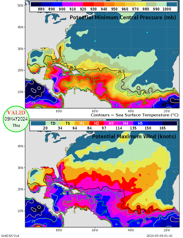
Not surprisingly, the Northern Gulf is capable of supporting a Cat 4 or a Cat 5 and it's only mid June!


0 likes
Michael
-
lonelymike
- S2K Supporter

- Posts: 634
- Joined: Sat Jul 26, 2008 10:12 am
- Location: walton county fla
Re: Atlantic Sea Surface Temperatures and Anomalies
x-y-no wrote:Weatherfreak000 wrote:lonelymike wrote:Big A and Weathersnoop you might both be right. I've heard arguments both ways so I'm not sure which is correct.
I've never ever, EVER heard an argument going in your favor Lonelymike. I mean....no offense but have you been hiding under a rock for the past 10 years?
As this map clearly shows that not only can the GOM sustain majors around this time....this year it is especially the case.
(Note to other posters: I dont remember the link but if someone could pull up that Heat Potential Map that specifically shows the category hurricane possible in certain areas and wants to post it for me that would be appreciated)
Actually, given that the warmest surface temperatures in the Gulf are along the Florida coast, it's notable that the TCHP is relatively low in the Florida shelf area.
And I recall numerous discussions here over the years where Derek Ortt would point out the tendency of storms to weaken as they make landfall along the Gulf coast. My understanding has been that this relates to the shallow waters leading to lowered heat potential.
Guess I come out from under the rock every once in a while eh weatherfreak
0 likes
GO SEMINOLES
-
bob rulz
- Category 5

- Posts: 1667
- Age: 34
- Joined: Sat Jan 28, 2006 7:30 pm
- Location: Salt Lake City, Utah
Re: Atlantic Sea Surface Temperatures and Anomalies
x-y-no wrote:Weatherfreak000 wrote:lonelymike wrote:Big A and Weathersnoop you might both be right. I've heard arguments both ways so I'm not sure which is correct.
I've never ever, EVER heard an argument going in your favor Lonelymike. I mean....no offense but have you been hiding under a rock for the past 10 years?
As this map clearly shows that not only can the GOM sustain majors around this time....this year it is especially the case.
(Note to other posters: I dont remember the link but if someone could pull up that Heat Potential Map that specifically shows the category hurricane possible in certain areas and wants to post it for me that would be appreciated)
Actually, given that the warmest surface temperatures in the Gulf are along the Florida coast, it's notable that the TCHP is relatively low in the Florida shelf area.
And I recall numerous discussions here over the years where Derek Ortt would point out the tendency of storms to weaken as they make landfall along the Gulf coast. My understanding has been that this relates to the shallow waters leading to lowered heat potential.
Not every storm is prone to this though. Audrey, Camille, and Charley are just a few examples.
0 likes
-
Weatherfreak000
Re: Atlantic Sea Surface Temperatures and Anomalies
x-y-no wrote:Weatherfreak000 wrote:lonelymike wrote:Big A and Weathersnoop you might both be right. I've heard arguments both ways so I'm not sure which is correct.
I've never ever, EVER heard an argument going in your favor Lonelymike. I mean....no offense but have you been hiding under a rock for the past 10 years?
As this map clearly shows that not only can the GOM sustain majors around this time....this year it is especially the case.
(Note to other posters: I dont remember the link but if someone could pull up that Heat Potential Map that specifically shows the category hurricane possible in certain areas and wants to post it for me that would be appreciated)
Actually, given that the warmest surface temperatures in the Gulf are along the Florida coast, it's notable that the TCHP is relatively low in the Florida shelf area.
And I recall numerous discussions here over the years where Derek Ortt would point out the tendency of storms to weaken as they make landfall along the Gulf coast. My understanding has been that this relates to the shallow waters leading to lowered heat potential.
I'm no scientist here, so take my opinion with a grain of salt. My take on that is massive, large cored systems such as Katrina, Ike, Rita, Gustav and Wilma (recent examples) have a tough time because they are so large they are susceptible to drawing in alot of dry air mass from the landmass itself, which causes it's core to erode and weaken. Not the SST's.
However, small-cored fast moving systems (Betsy and Camille being infamous examples in my hometown), were able to reliably sustain their inner cored and didnt lost much intensity going inland. I mean look at the heat content map right now. The Northern Gulf can sustain a Cat 5.
0 likes
- Bocadude85
- Category 5

- Posts: 2941
- Age: 37
- Joined: Mon Apr 18, 2005 2:20 pm
- Location: Honolulu,Hi
Re: Atlantic Sea Surface Temperatures and Anomalies
Hurricane Wilma was actually strengthening as it was approaching SW Florida. Dry air is usually not a problem for hurricanes making landfall in central or south Florida as they can tap into the warm moist air of either the gulf or atlantic.
0 likes
I think its not just that bocadude, but also because NE moving systems often will be able to tap into good upper divergence provided by the trough as it lifts the system out, that was certainly the case with both Charley and Wilma.
0 likes
Personal Forecast Disclaimer:
The posts in this forum are NOT official forecast and should not be used as such. They are just the opinion of the poster and may or may not be backed by sound meteorological data. They are NOT endorsed by any professional institution or storm2k.org. For official information, please refer to the NHC and NWS products
The posts in this forum are NOT official forecast and should not be used as such. They are just the opinion of the poster and may or may not be backed by sound meteorological data. They are NOT endorsed by any professional institution or storm2k.org. For official information, please refer to the NHC and NWS products
- Bocadude85
- Category 5

- Posts: 2941
- Age: 37
- Joined: Mon Apr 18, 2005 2:20 pm
- Location: Honolulu,Hi
Re:
KWT wrote:I think its not just that bocadude, but also because NE moving systems often will be able to tap into good upper divergence provided by the trough as it lifts the system out, that was certainly the case with both Charley and Wilma.
Yes that is also another factor KWT. But in general storms making landfall in South Florida do not have a problem with dry air being entrained into the circulation.
0 likes
-
Weatherfreak000
Re: Atlantic Sea Surface Temperatures and Anomalies
Also, landfalling south florida storms coming from the same direction as Charley and Wilma are typically fast moving and have alot of velocity to them which does wonders as far as maintaining the core. Landfalling systems in the N Gulf have the problem of just chugging along as a fairly consistent pace. This is why its important to have a smaller core so it can outlast the adverse elements.
0 likes
-
lonelymike
- S2K Supporter

- Posts: 634
- Joined: Sat Jul 26, 2008 10:12 am
- Location: walton county fla
Re: Atlantic Sea Surface Temperatures and Anomalies
Interesting arguements on both sides. I wonder where the pro-mets come down on this issue.
BTW I wasn't trying to start a flame war on this subject just throwing out some thoughts there. If I offended anybody it was not my intention
BTW I wasn't trying to start a flame war on this subject just throwing out some thoughts there. If I offended anybody it was not my intention
0 likes
GO SEMINOLES
- Ivanhater
- Storm2k Moderator

- Posts: 10852
- Age: 37
- Joined: Fri Jul 01, 2005 8:25 am
- Location: Pensacola
Re: Atlantic Sea Surface Temperatures and Anomalies
The problem with this is it doesnt matter if large systems pull in dry air once reaching the northern gulf, the surge and waves are the big problem here. There is a reason most of the most catastrophic and costliest storms are those that struck the northern gulf, i.e Camille, Ivan and Katrina to name a few. Ivan and Katrina produced the higest surge and waves ever recorded based on the coastline they hit.
Surge is a bigger killer than wind...
Surge is a bigger killer than wind...
0 likes
Michael
-
Weatherfreak000
Re: Atlantic Sea Surface Temperatures and Anomalies
I definitely agree. The situation certainly seems to become a contrast between Large-Structurally degrading hurricane landfalls with a larger storm surge (referring to N Gulf Landfalls), in comparison to what you may expect from a fast hurricane with a smaller core.
This is definitely something I consider when it comes to determining effects so its quite an improvement the NHC has changed the storm surge policy.
This is definitely something I consider when it comes to determining effects so its quite an improvement the NHC has changed the storm surge policy.
0 likes
-
bob rulz
- Category 5

- Posts: 1667
- Age: 34
- Joined: Sat Jan 28, 2006 7:30 pm
- Location: Salt Lake City, Utah
Using the Hurricane Severity Index (which evenly divides a storm's impact between intensity and size), the strongest storms to make landfall in the U.S. were Carla, Hugo, and Betsy, with Camille, Katrina, and Opal just behind. Interesting that 5 of the 6 were Gulf hurricanes.
The larger storms are almost always the ones that do the most damage, although of course the amount of advance warning and location of impact are ultimately the most important factors.
The larger storms are almost always the ones that do the most damage, although of course the amount of advance warning and location of impact are ultimately the most important factors.
0 likes
- cycloneye
- Admin

- Posts: 139080
- Age: 67
- Joined: Thu Oct 10, 2002 10:54 am
- Location: San Juan, Puerto Rico
Re: Atlantic Sea Surface Temperatures and Anomalies
This is today's data (17 of June) in this graphic and shows how warm is the Atlantic basin,not only the MDR. In contrast,the Pacific is the contrary for the most part and of course,in the equatorial area with La Nina charging up.


0 likes
Visit the Caribbean-Central America Weather Thread where you can find at first post web cams,radars
and observations from Caribbean basin members Click Here
and observations from Caribbean basin members Click Here
-
Scorpion
Oh I have no doubt once things get going, the Atlantic will probably pump out one after another...
0 likes
Personal Forecast Disclaimer:
The posts in this forum are NOT official forecast and should not be used as such. They are just the opinion of the poster and may or may not be backed by sound meteorological data. They are NOT endorsed by any professional institution or storm2k.org. For official information, please refer to the NHC and NWS products
The posts in this forum are NOT official forecast and should not be used as such. They are just the opinion of the poster and may or may not be backed by sound meteorological data. They are NOT endorsed by any professional institution or storm2k.org. For official information, please refer to the NHC and NWS products
- jasons2k
- Storm2k Executive

- Posts: 8076
- Age: 50
- Joined: Wed Jul 06, 2005 12:32 pm
- Location: The Woodlands, TX
Re: Atlantic Sea Surface Temperatures and Anomalies
The FL Keys are roasting - a sign of the excessive SSTs:
http://keysnews.com/
The calendar says it’s not summer yet, but the thermometer is spinning a different yarn. Marathon has suffered the hottest first half of June since the National Weather Service began tracking readings at the Florida Keys Marathon Airport a decade ago. The average temperature was 85.8 degrees, 3.6 degrees above normal.
In Key West, the first 15 days of the month were the fifth-hottest since 1948, with an average temperature of 85.3 degrees, according to readings from the Key West International Airport, meteorologist Tony Fuentes said.
http://keysnews.com/
0 likes
-
StormClouds63
- Category 2

- Posts: 583
- Age: 60
- Joined: Tue May 13, 2008 11:56 am
- Location: Southwest Louisiana
Re:
bob rulz wrote:Using the Hurricane Severity Index (which evenly divides a storm's impact between intensity and size), the strongest storms to make landfall in the U.S. were Carla, Hugo, and Betsy, with Camille, Katrina, and Opal just behind. Interesting that 5 of the 6 were Gulf hurricanes.
The larger storms are almost always the ones that do the most damage, although of course the amount of advance warning and location of impact are ultimately the most important factors.
Here's more details on the Hurricane Severity Index.
http://katrina.impactweather.com/hsi/hsi.pdf
http://www.impactweather.com/HSI.pdf
Slide 15 (first link above) provides rankings of infamous storms based on intensity and size. One thing I found interesting on slide 15 ... they have Andrew's intensity value at 23, while Camille is a 22. If Andrew came into south Florida with highest sustained winds of 165 m.p.h., can we then assume that they're estimating Camille's winds somewhere around 155-160 m.p.h. at Mississippi landfall?
0 likes
- jasons2k
- Storm2k Executive

- Posts: 8076
- Age: 50
- Joined: Wed Jul 06, 2005 12:32 pm
- Location: The Woodlands, TX
Re: Re:
StormClouds63 wrote:bob rulz wrote:Using the Hurricane Severity Index (which evenly divides a storm's impact between intensity and size), the strongest storms to make landfall in the U.S. were Carla, Hugo, and Betsy, with Camille, Katrina, and Opal just behind. Interesting that 5 of the 6 were Gulf hurricanes.
The larger storms are almost always the ones that do the most damage, although of course the amount of advance warning and location of impact are ultimately the most important factors.
Here's more details on the Hurricane Severity Index.
http://katrina.impactweather.com/hsi/hsi.pdf
http://www.impactweather.com/HSI.pdf
Slide 15 (first link above) provides rankings of infamous storms based on intensity and size. One thing I found interesting on slide 15 ... they have Andrew's intensity value at 23, while Camille is a 22. If Andrew came into south Florida with highest sustained winds of 165 m.p.h., can we then assume that they're estimating Camille's winds somewhere around 155-160 m.p.h. at Mississippi landfall?
I'm pretty amazed that Donna is nowhere on the list in Table 3. It made two US landfalls as a Cat. 4.
0 likes
-
StormClouds63
- Category 2

- Posts: 583
- Age: 60
- Joined: Tue May 13, 2008 11:56 am
- Location: Southwest Louisiana
Re: Atlantic Sea Surface Temperatures and Anomalies
I'm pretty amazed that Donna is nowhere on the list in Table 3. It made two US landfalls as a Cat. 4.
Looks like they omitted a number of significant storms. I came up with this list off the top of my head. Probably others as well:
Donna (1960)
Hilda (1964)
Beulah (1967)
Celia (1970)
Eloise (1975)
Anita (1977)
David (1979)
Frederick (1979)
Elena (1985)
0 likes
- Ivanhater
- Storm2k Moderator

- Posts: 10852
- Age: 37
- Joined: Fri Jul 01, 2005 8:25 am
- Location: Pensacola
Re: Atlantic Sea Surface Temperatures and Anomalies
The Northern Gulf is breaking some records. Some of the highest values in the entire basin!


0 likes
Michael
Who is online
Users browsing this forum: chaser1, KirbyDude25 and 198 guests

