

Global model runs discussion
Moderator: S2k Moderators

Re: Global Model Runs Discussion
Model rundown or maybee I should call it Model theater with all the back and forth and fantasy.
00z CMC takes the central atlantic wave and develops it and makes it all the way across and slames into Honduras.
00Z FIM still develops the E.Carib wave and really develops it into the W. Carib and slams into the Yucatan. FIM is still the strongest of all by far in the long run.
06Z GFS no longer develops the W. Carib storm and dropped it in the last two runs but is showing development of the E. Carib wave in hr 153 similar to the other models but slams that wave into Hispaniola.
00z UKMET shows the central atlantic wave through 72hrs on the PSU site and then tries to develop in the E. Carib as per Cycloneye's post in the longer run.
00z NAVGEM weak wave that carries from the central atlantic but does not develop.
00Z Euro shows the central atlantic wave and carries it into the E.carib where is slams into the north coast of S. America and really never develops.
So I guess the takeaway is that the wave in the Central Atlantic is a possble player as Gatorcane pointed out a few days ago and to focus on the E. Carib as the area for possible development in 7 days. Maybe we can get some more consistency as time goes by.
0 likes
The following post is NOT an official forecast and should not be used as such. It is just the opinion of the poster and may or may not be backed by sound meteorological data. It is NOT endorsed by any professional institution including storm2k.org For Official Information please refer to the NHC and NWS products.
-
Blown Away

- S2K Supporter

- Posts: 9861
- Joined: Wed May 26, 2004 6:17 am
Re: Global Model Runs Discussion
00z FIM moves this system through Yucatan, into BOC, and seems to turn towards Texas.
http://fim.noaa.gov/FIM/Welcome.cgi?dsK ... 2013+-+12Z (Click 10m Wind Loop)
http://fim.noaa.gov/FIM/Welcome.cgi?dsK ... 2013+-+12Z (Click 10m Wind Loop)
0 likes
Hurricane Eye Experience: David 79, Irene 99, Frances 04, Jeanne 04, Wilma 05...
Hurricane Brush Experience: Andrew 92, Erin 95, Floyd 99, Matthew 16, Irma 17, Ian 22, Nicole 22…
Hurricane Brush Experience: Andrew 92, Erin 95, Floyd 99, Matthew 16, Irma 17, Ian 22, Nicole 22…
Re: Global Model Runs Discussion
Blown Away wrote:00z FIM moves this system through Yucatan, into BOC, and seems to turn towards Texas.
http://fim.noaa.gov/FIM/Welcome.cgi?dsK ... 2013+-+12Z
Yea I saw that. The FIMM has been consistently ramping this up once it hits the W.Carib. I wonder if anyone can provide info on where this model stands in terms of reilability, since I have not seen it mentioned in the model comparision. From what I have seen so far, it seems like a 2nd tier model, but it has picked up on some systems before other models. What I like is that you can see it out in the long range (240+hrs) such as the GFS which helps if you are trying to compare and see whether or not the GFS long range solution is pure fantasy.
0 likes
The following post is NOT an official forecast and should not be used as such. It is just the opinion of the poster and may or may not be backed by sound meteorological data. It is NOT endorsed by any professional institution including storm2k.org For Official Information please refer to the NHC and NWS products.
-
tolakram
- Admin

- Posts: 19165
- Age: 60
- Joined: Sun Aug 27, 2006 8:23 pm
- Location: Florence, KY (name is Mark)
Re: Global Model Runs Discussion
I think these longer range runs are having issues with reality.
Current shear tendency
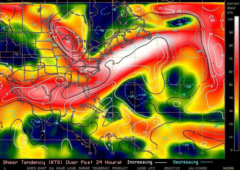
The 12Z GFS shear forecast, which goes out to 180 hours.
http://moe.met.fsu.edu/cgi-bin/gfstc2.cgi?time=2013102500&field=850-200mb+Shear&hour=Animation
Current shear tendency
The 12Z GFS shear forecast, which goes out to 180 hours.
http://moe.met.fsu.edu/cgi-bin/gfstc2.cgi?time=2013102500&field=850-200mb+Shear&hour=Animation
0 likes
M a r k
- - - - -
Join us in chat: Storm2K Chatroom Invite. Android and IOS apps also available.
The posts in this forum are NOT official forecasts and should not be used as such. Posts are NOT endorsed by any professional institution or STORM2K.org. For official information and forecasts, please refer to NHC and NWS products.
-
gatorcane

- S2K Supporter
- Posts: 23499
- Age: 46
- Joined: Sun Mar 13, 2005 3:54 pm
- Location: Boca Raton, FL
Re: Global Model Runs Discussion
cycloneye wrote:Hey guys,the conservative UKMET has something in Caribbean and is less than 144 hours.
NEW TROPICAL STORM FORECAST TO DEVELOP AFTER 132 HOURS
FORECAST POSITION AT T+132 : 14.3N 71.4W
VERIFYING TIME POSITION STRENGTH TENDENCY
-------------- -------- -------- --------
12UTC 30.10.2013 14.3N 71.4W WEAK
00UTC 31.10.2013 14.3N 74.4W WEAK LITTLE CHANGE
The GFS is showing something in the Eastern-Central Caribbean now similar to the UKMET.
168 hours:

288 hours (another system forms):

The CMC is showing what looks like a hurricane in the Western Caribbean now at 240 hours:

Last edited by gatorcane on Fri Oct 25, 2013 12:21 pm, edited 1 time in total.
0 likes
-
CourierPR

- Category 5

- Posts: 1325
- Age: 70
- Joined: Tue Aug 31, 2004 7:53 pm
- Location: Pompano Beach, Florida
Re: Global Model Runs Discussion
Met. Larry Cosgrove tweeted about Caribbean development around first week of November.
0 likes
-
cycloneye

- Admin
- Posts: 139051
- Age: 67
- Joined: Thu Oct 10, 2002 10:54 am
- Location: San Juan, Puerto Rico
Re: Global Model Runs Discussion
blp wrote:Model rundown or maybee I should call it Model theater with all the back and forth and fantasy.
00z CMC takes the central atlantic wave and develops it and makes it all the way across and slames into Honduras.
00Z FIM still develops the E.Carib wave and really develops it into the W. Carib and slams into the Yucatan. FIM is still the strongest of all by far in the long run.
06Z GFS no longer develops the W. Carib storm and dropped it in the last two runs but is showing development of the E. Carib wave in hr 153 similar to the other models but slams that wave into Hispaniola.
00z UKMET shows the central atlantic wave through 72hrs on the PSU site and then tries to develop in the E. Carib as per Cycloneye's post in the longer run.
00z NAVGEM weak wave that carries from the central atlantic but does not develop.
00Z Euro shows the central atlantic wave and carries it into the E.carib where is slams into the north coast of S. America and really never develops.
So I guess the takeaway is that the wave in the Central Atlantic is a possble player as Gatorcane pointed out a few days ago and to focus on the E. Carib as the area for possible development in 7 days. Maybe we can get some more consistency as time goes by.
Well,12z UKMET has nothing so go figure how the models are doing with the back and forth.
0 likes
Visit the Caribbean-Central America Weather Thread where you can find at first post web cams,radars
and observations from Caribbean basin members Click Here
and observations from Caribbean basin members Click Here
Re: Global Model Runs Discussion
12z NAVGEM for the first time has come on board with the Central Atlantic Wave reaching the W. Carib. and developing into a moderate tropical storm. It seems fast though because it reaches the W. Carib in 180hrs. But the models are coming around to the idea now. Waiting on the Euro.

0 likes
The following post is NOT an official forecast and should not be used as such. It is just the opinion of the poster and may or may not be backed by sound meteorological data. It is NOT endorsed by any professional institution including storm2k.org For Official Information please refer to the NHC and NWS products.
Re: Global Model Runs Discussion
12z FIM starts developing at 126hr in the E.Carib. and continues to bomb it out when it gets into the W. Carib. So far the most consistent model from run to run. Let's see if it can pull this off.
126hr
http://fim.noaa.gov/FIM/for_web/fim7_jet/2013102512/244/wind_850_f126.png
300hr bombs it out close to the yuctan channel
http://fim.noaa.gov/FIM/for_web/fim7_jet/2013102512/244/wind_850_f300.png
336hr takes over the BOC.
http://fim.noaa.gov/FIM/for_web/fim7_jet/2013102512/244/wind_850_f336.png
0 likes
The following post is NOT an official forecast and should not be used as such. It is just the opinion of the poster and may or may not be backed by sound meteorological data. It is NOT endorsed by any professional institution including storm2k.org For Official Information please refer to the NHC and NWS products.
Re: Global Model Runs Discussion
Caribbean set up is starting to gel with the front pressing the tropical air into the SW Caribbean.
0 likes
-
gatorcane
- S2K Supporter
- Posts: 23499
- Age: 46
- Joined: Sun Mar 13, 2005 3:54 pm
- Location: Boca Raton, FL
Re: Global Model Runs Discussion
blp wrote:12z FIM starts developing at 126hr in the E.Carib. and continues to bomb it out when it gets into the W. Carib. So far the most consistent model from run to run. Let's see if it can pull this off.
126hr
http://fim.noaa.gov/FIM/for_web/fim7_jet/2013102512/244/wind_850_f126.png
300hr bombs it out close to the yuctan channel
http://fim.noaa.gov/FIM/for_web/fim7_jet/2013102512/244/wind_850_f300.png
336hr takes over the BOC.
http://fim.noaa.gov/FIM/for_web/fim7_jet/2013102512/244/wind_850_f336.png
Wow that is a monster. Let us hope the FIM is wrong but it has been darn consistent with this.
Looking across the tropical atlantic this afternoon, there are some healthy waves heading west towards the Caribbean (one is approaching the Leewards and the other is in the South Central Atlantic). These waves are loaded with moisture (especially the South Atlantic wave) unlike what we have seen this entire season so far. I can see why the models are starting to show some development especially with the MJO pulse arriving also.

0 likes
Re: Global Model Runs Discussion
The 12z Euro showing a closed isobar and a little bit stronger wave at 192hr in the C. Carib. and then just shoots north getting picked up by a trough by 240hr. Not a whole lot but this is more than I have seen from the Euro so far.
192hr
http://img824.imageshack.us/img824/2251/jd6z.gif
240hr
http://img14.imageshack.us/img14/7764/doae.gif
192hr
http://img824.imageshack.us/img824/2251/jd6z.gif
240hr
http://img14.imageshack.us/img14/7764/doae.gif
0 likes
The following post is NOT an official forecast and should not be used as such. It is just the opinion of the poster and may or may not be backed by sound meteorological data. It is NOT endorsed by any professional institution including storm2k.org For Official Information please refer to the NHC and NWS products.
Re: Global Model Runs Discussion
I was going to start a separate thread but will post here instead - things seem to be getting grumpy in the Western Caribbean Sea (grumpy is not a meteorological term, I know, but it seems to fit)...
We'll see what happens per the models...
Frank
We'll see what happens per the models...
Frank
0 likes
Re: Global Model Runs Discussion
Frank2 wrote:I was going to start a separate thread but will post here instead - things seem to be getting grumpy in the Western Caribbean Sea (grumpy is not a meteorological term, I know, but it seems to fit)...
We'll see what happens per the models...
Frank
There was a thread started by Gatorcane a few days ago that would be apporpriate to reopen if we see the models still showing development. The link is below:
viewtopic.php?f=31&t=115891
0 likes
The following post is NOT an official forecast and should not be used as such. It is just the opinion of the poster and may or may not be backed by sound meteorological data. It is NOT endorsed by any professional institution including storm2k.org For Official Information please refer to the NHC and NWS products.
Re: Global Model Runs Discussion
Ok, now I know this is fantasy. Check out the FIM 8 with a system over Key West in 306hr. I am just starting to get to know the FIM model and its variations but if this turns out to be a bust then the FIM will take over the crown from the GFS as the phantom storm king.

0 likes
The following post is NOT an official forecast and should not be used as such. It is just the opinion of the poster and may or may not be backed by sound meteorological data. It is NOT endorsed by any professional institution including storm2k.org For Official Information please refer to the NHC and NWS products.
-
gatorcane
- S2K Supporter
- Posts: 23499
- Age: 46
- Joined: Sun Mar 13, 2005 3:54 pm
- Location: Boca Raton, FL
Yikes  I have been following the FIM to some extent this season and it has indeed spun up some phantom storms in the long-range but nothing like the CMC! I have seen where it has overestimated the strength of existing systems in the medium range too.
The situation that looks to be unfolding in the Caribbean is a bit disturbing (no pun intended) to say the least...lots of model watching ahead...
The situation that looks to be unfolding in the Caribbean is a bit disturbing (no pun intended) to say the least...lots of model watching ahead...
0 likes
-
hurricanes1234
- Category 5
- Posts: 2903
- Joined: Sat Jul 28, 2012 6:19 pm
- Location: Trinidad and Tobago
Re: Global Model Runs Discussion
Sorry, but I'll only believe it when it starts being mentioned in either of the TWOs. Since it is 2013, you'd never know before hand if wind shear or dry air abruptly make their way into the system's path, hindering it and destroying it.
0 likes
PLEASE NOTE: With the exception of information from weather agencies that I may copy and paste here, my posts will NEVER be official, since I am NOT a meteorologist. They are solely my amateur opinion, and may or may not be accurate. Therefore, please DO NOT use them as official details, particularly when making important decisions. Thank you.
-
cycloneye
- Admin
- Posts: 139051
- Age: 67
- Joined: Thu Oct 10, 2002 10:54 am
- Location: San Juan, Puerto Rico
Re: Global Model Runs Discussion
Maybe from one of these waves something pops up that some models are showing different scenarios.

0 likes
Visit the Caribbean-Central America Weather Thread where you can find at first post web cams,radars
and observations from Caribbean basin members Click Here
and observations from Caribbean basin members Click Here
Re: Global Model Runs Discussion
Look at the 18z Navgem coming strong at 144hrs.

0 likes
The following post is NOT an official forecast and should not be used as such. It is just the opinion of the poster and may or may not be backed by sound meteorological data. It is NOT endorsed by any professional institution including storm2k.org For Official Information please refer to the NHC and NWS products.
Who is online
Users browsing this forum: No registered users and 42 guests