Hurricane Camille Satellite Image

This is the general tropical discussion area. Anyone can take their shot at predicting a storms path.

Moderator: S2k Moderators

Forum rules

The posts in this forum are NOT official forecasts and should not be used as such. They are just the opinion of the poster and may or may not be backed by sound meteorological data. They are NOT endorsed by any professional institution or STORM2K. For official information, please refer to products from the National Hurricane Center and National Weather Service.

Help Support Storm2K
Message
Author
User avatar
Ptarmigan
Category 5
Category 5
Posts: 5272
Joined: Wed Aug 16, 2006 9:06 pm

Hurricane Camille Satellite Image

#1 Postby Ptarmigan » Sun Mar 22, 2009 11:02 pm

Here are some satellite images of Hurricane Camille.

Image

Image

Looks like the eye of Camille is quite small. Also the cloud base is quite large, despite the fact that Camille was smaller than Katrina. From what I have read, Camille had hurricane force winds extending around 50 to 60 miles, while Katrina was around 125 miles.
0 likes   

User avatar
KWT
Category 5
Category 5
Posts: 31390
Joined: Tue Aug 17, 2004 11:02 am
Location: UK!!!

#2 Postby KWT » Mon Mar 23, 2009 7:11 am

Whats really interesting is the presentation on the later image seems worse then Camille in the middle of the gulf with that tight eye seemingly going, wouldn't call that a cat-5 presentation but then again looks can decieve!
0 likes   

Derek Ortt

Re:

#3 Postby Derek Ortt » Mon Mar 23, 2009 9:55 am

KWT wrote:Whats really interesting is the presentation on the later image seems worse then Camille in the middle of the gulf with that tight eye seemingly going, wouldn't call that a cat-5 presentation but then again looks can decieve!


tends to confirm my suspicion that Camielle was NOT a cat 5 at landfall. Then again, we could have used that info on August 28, 2005
0 likes   

User avatar
KWT
Category 5
Category 5
Posts: 31390
Joined: Tue Aug 17, 2004 11:02 am
Location: UK!!!

#4 Postby KWT » Mon Mar 23, 2009 9:58 am

Indeed that image only suggests around a higher end of cat-3 to me, certainly doesn't look like a category-5 hurricane I have to admit!
0 likes   

Derek Ortt

#5 Postby Derek Ortt » Mon Mar 23, 2009 10:02 am

It almost looks like a concentric eyewall, though we'd need microwave to confirm (which of course, we did not have then)
0 likes   

Ed Mahmoud

Re: Hurricane Camille Satellite Image

#6 Postby Ed Mahmoud » Mon Mar 23, 2009 10:42 am

Where did the estimate of 26.61 inches ( 901 mb) on August 17th at 4 pm come from? That had to be aircraft data, no?
0 likes   

CrazyC83
Professional-Met
Professional-Met
Posts: 33393
Joined: Tue Mar 07, 2006 11:57 pm
Location: Deep South, for the first time!

#7 Postby CrazyC83 » Mon Mar 23, 2009 12:20 pm

The 901mb is aircraft data. It seems they didn't consider it valid but I personally believe that it was. (The previous pass was about 16 hours earlier and had a 905 pressure, so it probably was stronger in between - I am guessing between 895 and 898mb was Camille's minimum pressure).

I believe that Camille also had 165 kt winds at flight level at that point, which would be 150 kt at the surface (since I believe the flight was at 700mb). It was probably 155-160 kt at peak intensity between flights.
0 likes   

Sanibel
Category 5
Category 5
Posts: 10348
Joined: Mon Aug 30, 2004 11:06 pm
Location: Offshore SW Florida

Re: Hurricane Camille Satellite Image

#8 Postby Sanibel » Mon Mar 23, 2009 12:51 pm

Good symmetry.

Looks like it drew all the way down to the Pacific with its southern inflow. (Caribbean too)
0 likes   

margiek
Tropical Depression
Tropical Depression
Posts: 72
Joined: Fri Nov 28, 2008 9:50 pm

Re: Hurricane Camille Satellite Image

#9 Postby margiek » Mon Mar 23, 2009 12:59 pm

The appearance of Camille in the 2nd (VIS) image does not rule out a Cat 5. It shows a clear well-formed small eye with sunlight reflecting off the eastern side of the upper eyewall, and a very bright CDO. The image graininess and lower resolution hides details that we are used to seeing, such as the radial outflow pattern on the CDO, and the cirrus transverse banding (which can just be made out on the outermost wave of outflow to the northwest). The grey scale also seems to be a little different than today's images, giving a slightly different, more opaque appearance to the high-level clouds.

The image is similar to other Cat 5s with small eyes. This is the only one I could get my hands on quickly during lunch:

http://www.nrlmry.navy.mil/tcdat/tc04/W ... -1368E.jpg

The image also shows the strong outflow patterns into the Caribbean and poleward.
0 likes   

User avatar
wxman57
Moderator-Pro Met
Moderator-Pro Met
Posts: 22480
Age: 66
Joined: Sat Jun 21, 2003 8:06 pm
Location: Houston, TX (southwest)

Re: Hurricane Camille Satellite Image

#10 Postby wxman57 » Mon Mar 23, 2009 5:57 pm

There are more Camille images here:

http://www.tropmet.com/gallery/hurrican ... amille.htm

And all archived images are available on the NCDC site here at the link below. In fact, you'll find quite a number of interesting old satellite pictures on NCDC's server:

http://www1.ncdc.noaa.gov/pub/data/images

For example, here's a comparison of Katrina vs. Camille using the same map background:

Image

The Camille images are under a variety of names - "camille...", "hurr-camille", "hurricane-camille".

Here's a big shot:
Image

Celia is in there, too:
Image
0 likes   

User avatar
MGC
S2K Supporter
S2K Supporter
Posts: 5792
Joined: Sun Mar 23, 2003 9:05 pm
Location: Pass Christian MS, or what is left.

Re: Hurricane Camille Satellite Image

#11 Postby MGC » Mon Mar 23, 2009 8:40 pm

There is also a radar picture of Camille taken from New Orleans out there somewhere. It shows a intact eyewall with about a 8 mile diameter eye. The barometer that measured the landfall pressure of 909mb was checked by the weather service in a chamber and the reading was accurate. How many hurricanes with a 8 mile closed eye and 909mb pressure are anything but a Cat-5. Can someone direct me to an example?....MGC
0 likes   

User avatar
KWT
Category 5
Category 5
Posts: 31390
Joined: Tue Aug 17, 2004 11:02 am
Location: UK!!!

#12 Postby KWT » Mon Mar 23, 2009 9:13 pm

I could well believe that Camille was below 900mbs given it was probably going over the loop current and had a very impressive presentation. Rita proved you can go sub 900mbs in a similar region.
0 likes   

User avatar
Normandy
Category 5
Category 5
Posts: 2293
Joined: Sun Oct 10, 2004 12:31 am
Location: Houston, TX

#13 Postby Normandy » Mon Mar 23, 2009 9:50 pm

Couple things I've noticed about Camille from this post:

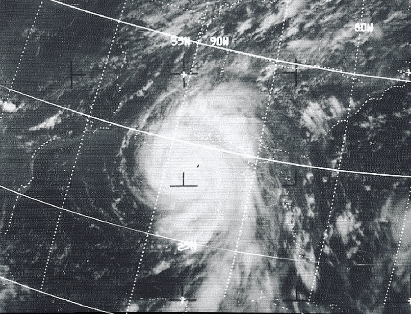
1) Looking at the slideshow on the first site Wxman57 posted, Camille looks like it went under deep intensification in the middle of the gulf, then started to undergo an ERC while approaching the coast. The image of it near the coast are similar to these IMO.

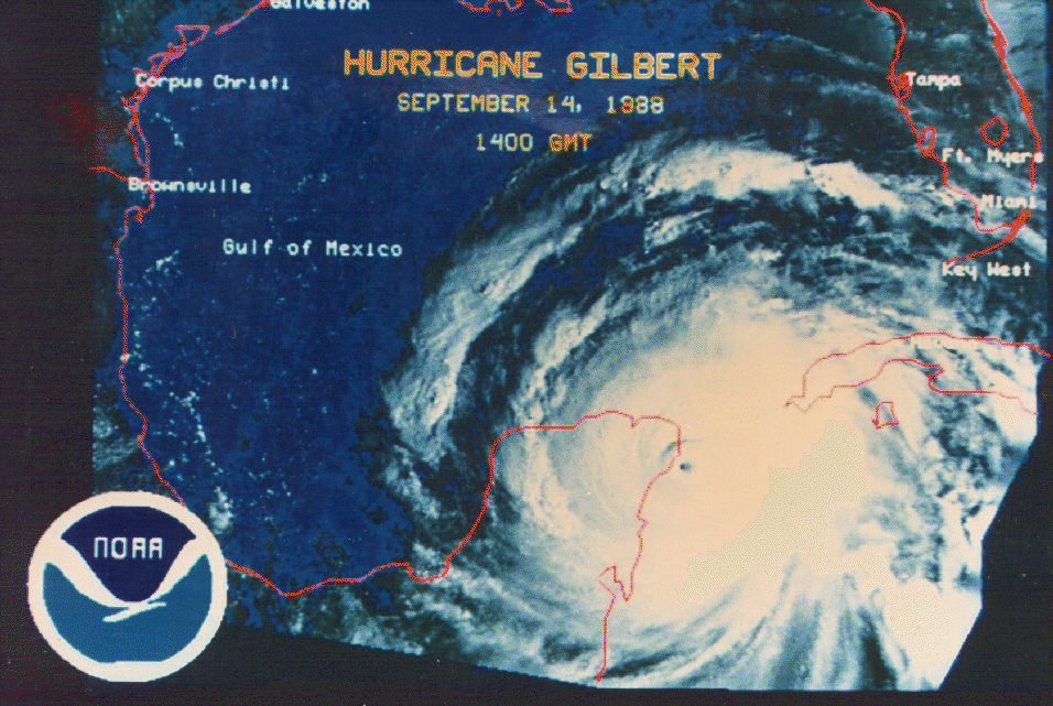
http://www.stormcenter.com/media/enviro ... 020_01.jpg
http://www.nhc.noaa.gov/gifs/1988gilbert.gif


2) Looking at Katrina and Camille side by side, its is painfully clear which is the better developed hurricane (IE which is the more intense hurricane). Katrina's asymmetry is clearly evident, while Camille is pretty healthy in all quads.

Can't really say whether it was a 5 or not (My only objection is the lack of severe tree damage, but surge could have covered the trees). Surely could not have been anything less than a 140-145 mph cane, and surely could not have been a 190 mph cane. Definitely somewhere in between. Also, pressure doesn't prove whether or not Camille was a Cat 5. Wilma and Rita had pressures lower than Camille with Cat 4 winds. Katrina had a similar pressure to Andrew, and the difference in winds between the two was astronomical. JMO.
0 likes   

CrazyC83
Professional-Met
Professional-Met
Posts: 33393
Joined: Tue Mar 07, 2006 11:57 pm
Location: Deep South, for the first time!

Re: Hurricane Camille Satellite Image

#14 Postby CrazyC83 » Mon Mar 23, 2009 9:57 pm

MGC wrote:There is also a radar picture of Camille taken from New Orleans out there somewhere. It shows a intact eyewall with about a 8 mile diameter eye. The barometer that measured the landfall pressure of 909mb was checked by the weather service in a chamber and the reading was accurate. How many hurricanes with a 8 mile closed eye and 909mb pressure are anything but a Cat-5. Can someone direct me to an example?....MGC


Based on satellite and radar shots I have seen, it appears Camille had concentric eyewalls at landfall from my guess.

http://www.nhc.noaa.gov/archive/storm_wallets/cdmp/

Black - recon pressure
Red - surface pressure
Blue - best track estimate (my guess, not official)

14/1200 - 1002
14/1559 - 999
14/1800 - 997
15/0000 - 994
15/0140 - 991
15/0600 - 984
15/1100 - 970
15/1200 - 969
15/1232 - 969
15/1519 - 964
15/1800 - 963
15/2200 - 961 - Cuba landfall
15/2317 - 966
16/0000 - 966
16/0600 - 965
16/1200 - 949
16/1800 - 923
16/2004 - 908
17/0000 - 907
17/0108 - 905
17/0600 - 899
17/1200 - 895 - Minimum pressure
17/1800 - 901
17/1957 - 901
17/2300 - 904 - Closest approach to Louisiana
18/0000 - 906
15/0330 - 909 - Mississippi landfall
0 likes   

User avatar
wxman57
Moderator-Pro Met
Moderator-Pro Met
Posts: 22480
Age: 66
Joined: Sat Jun 21, 2003 8:06 pm
Location: Houston, TX (southwest)

Re: Hurricane Camille Satellite Image

#15 Postby wxman57 » Mon Mar 23, 2009 10:08 pm

Found this Camille radar shot from Pensacola radar near landfall. Just did a Google image search for Camille Radar:

Image
0 likes   

CrazyC83
Professional-Met
Professional-Met
Posts: 33393
Joined: Tue Mar 07, 2006 11:57 pm
Location: Deep South, for the first time!

#16 Postby CrazyC83 » Mon Mar 23, 2009 10:11 pm

Definitely looks like it is entering an ERC at that point.
0 likes   

Derek Ortt

Re: Hurricane Camille Satellite Image

#17 Postby Derek Ortt » Mon Mar 23, 2009 10:13 pm

MGC wrote:There is also a radar picture of Camille taken from New Orleans out there somewhere. It shows a intact eyewall with about a 8 mile diameter eye. The barometer that measured the landfall pressure of 909mb was checked by the weather service in a chamber and the reading was accurate. How many hurricanes with a 8 mile closed eye and 909mb pressure are anything but a Cat-5. Can someone direct me to an example?....MGC


Wilma right before its EWRC. Was 892 and a small eye... yet cat 4
0 likes   

User avatar
Ptarmigan
Category 5
Category 5
Posts: 5272
Joined: Wed Aug 16, 2006 9:06 pm

Re: Hurricane Camille Satellite Image

#18 Postby Ptarmigan » Mon Mar 23, 2009 11:17 pm

Derek Ortt wrote:
Wilma right before its EWRC. Was 892 and a small eye... yet cat 4


Wasn't the ambient pressure lower that time when it was at 892 mb and 155 mph? It was 1003 millibars. I know at the time, Wilma had hurricane force winds extending up to 60 miles at the time.
0 likes   

User avatar
Ptarmigan
Category 5
Category 5
Posts: 5272
Joined: Wed Aug 16, 2006 9:06 pm

Re: Hurricane Camille Satellite Image

#19 Postby Ptarmigan » Mon Mar 23, 2009 11:26 pm

CrazyC83 wrote:
MGC wrote:There is also a radar picture of Camille taken from New Orleans out there somewhere. It shows a intact eyewall with about a 8 mile diameter eye. The barometer that measured the landfall pressure of 909mb was checked by the weather service in a chamber and the reading was accurate. How many hurricanes with a 8 mile closed eye and 909mb pressure are anything but a Cat-5. Can someone direct me to an example?....MGC


Based on satellite and radar shots I have seen, it appears Camille had concentric eyewalls at landfall from my guess.

http://www.nhc.noaa.gov/archive/storm_wallets/cdmp/

Black - recon pressure
Red - surface pressure
Blue - best track estimate (my guess, not official)

14/1200 - 1002
14/1559 - 999
14/1800 - 997
15/0000 - 994
15/0140 - 991
15/0600 - 984
15/1100 - 970
15/1200 - 969
15/1232 - 969
15/1519 - 964
15/1800 - 963
15/2200 - 961 - Cuba landfall
15/2317 - 966
16/0000 - 966
16/0600 - 965
16/1200 - 949
16/1800 - 923
16/2004 - 908
17/0000 - 907
17/0108 - 905
17/0600 - 899
17/1200 - 895 - Minimum pressure
17/1800 - 901
17/1957 - 901
17/2300 - 904 - Closest approach to Louisiana
18/0000 - 906
15/0330 - 909 - Mississippi landfall


I looked at the link and I saw what is suppose to be TS Claudette radar image. It is not really that clear. Here is a satellite image I found of TS Claudette in 1979.

Image
0 likes   

User avatar
KWT
Category 5
Category 5
Posts: 31390
Joined: Tue Aug 17, 2004 11:02 am
Location: UK!!!

#20 Postby KWT » Tue Mar 24, 2009 7:41 am

I think there is little doubt that Camille was a cat-5 in the gulf, it really looks amazing on the first image on this page, the main debate has to be whether it was a cat-5 upon landfall?
0 likes   


Return to “Talkin' Tropics”

Who is online

Users browsing this forum: AtlanticWind, Cpv17 and 201 guests