
Tropical Wave north of the Greater Antilles
Moderator: S2k Moderators
Forum rules

The posts in this forum are NOT official forecasts and should not be used as such. They are just the opinion of the poster and may or may not be backed by sound meteorological data. They are NOT endorsed by any professional institution or STORM2K. For official information, please refer to products from the National Hurricane Center and National Weather Service.
-
cycloneye

- Admin

- Posts: 149214
- Age: 69
- Joined: Thu Oct 10, 2002 10:54 am
- Location: San Juan, Puerto Rico
Tropical Wave north of the Greater Antilles
This wave has looked impressive since it was in Eastern Africa.Lets see how the models treat this one down the road.Click symbol to see a closeup view.Image updates every 15 minutes.
0 likes

-
ConvergenceZone
.gif)
- Category 5

- Posts: 5241
- Joined: Fri Jul 29, 2005 1:40 am
- Location: Northern California
Re: Strong wave inside Africa
0 likes
-
cycloneye
- Admin
- Posts: 149214
- Age: 69
- Joined: Thu Oct 10, 2002 10:54 am
- Location: San Juan, Puerto Rico
Re: Vigorous wave inside Africa
This is one of the most impressive waves that I haved seen in the last two years.

0 likes
-
otowntiger
- Category 5
- Posts: 1932
- Joined: Tue Aug 31, 2004 7:06 pm
Re: Vigorous wave inside Africa
cycloneye wrote:This is one of the most impressive waves that I haved seen in the last two years.
The question of course remains, can it hold together as it leaves shore.
BTW, O/T but that image really does illustrate the fautly initialization of all those models for 94L. It seems way west and south of there. It also illustrates how disorganized it is, but interesting nonetheless.
0 likes
Re: Vigorous wave inside Africa
It is well organized ATTM, that's for certain...
Of course if it does come off that well orgainzed the chance of an early recurve is pretty high...
Frances (1980) drove everyone crazy at the NHC when it became a hurricane soon after passing the CVI (everyone was nervous after the Hurricane Allen experience in early August), but Frances made a very fast recurve soon after...
http://upload.wikimedia.org/wikipedia/c ... _track.png
Frank
0 likes
-
otowntiger
- Category 5
- Posts: 1932
- Joined: Tue Aug 31, 2004 7:06 pm
Re: Vigorous wave inside Africa
Frank2 wrote:It is well organized ATTM, that's for certain...
Of course if it does come off that well orgainzed the chance of an early recurve is pretty high...
Frances (1980) drove everyone crazy at the NHC when it became a hurricane soon after passing the CVI (everyone was nervous after the Hurricane Allen experience in early August), but Frances made a very fast recurve soon after...
http://upload.wikimedia.org/wikipedia/c ... _track.png
Frank
Thats' a very good point Frank. We shouldn't get very excited over much of nothing in the Tropics until it actually happens. This is probably going to be one of those years in which there is not much excitement. The strong storms are re-curving the weak ones are, well weak and pitiful.
0 likes
-
CourierPR

- Category 5
- Posts: 1336
- Age: 72
- Joined: Tue Aug 31, 2004 7:53 pm
- Location: Pompano Beach, Florida
Re: Vigorous wave inside Africa
Several years ago, Joe Bastardi, of AccuWeather, wrote in a column that there was evidence to show that Donna in 1960 came off Africa as a hurricane.
0 likes


Re: Vigorous wave inside Africa
CourierPR wrote:Several years ago, Joe Bastardi, of AccuWeather, wrote in a column that there was evidence to show that Donna in 1960 came off Africa as a hurricane.
How is that possible? I though you had to have warm waters underneath the storm to provide enough energy for the storm to strenthen into a hurricane.
0 likes
-
Annie Oakley

- Category 5
- Posts: 1103
- Joined: Tue Jul 31, 2007 12:54 pm
- Location: Texas
-
HURAKAN

- Professional-Met

- Posts: 46084
- Age: 39
- Joined: Thu May 20, 2004 4:34 pm
- Location: Key West, FL
- Contact:
Re:
Annie Oakley wrote:Hurakan and Cycloneye-those pics and graphics are stunning! Thanks for showing them....uhhhh-do you guys ever sleep lol?
Cyclogenesis-yes-cyclogenesis. Has to have a birth certificate right?
I do sleep. About 5 to 6 hours every night. But during the hurricane season I can't wait for the sleeping time to be over to continue tracking storms. Here is the latest! WOW!

0 likes
-
Annie Oakley
- Category 5
- Posts: 1103
- Joined: Tue Jul 31, 2007 12:54 pm
- Location: Texas
-
HURAKAN
- Professional-Met
- Posts: 46084
- Age: 39
- Joined: Thu May 20, 2004 4:34 pm
- Location: Key West, FL
- Contact:
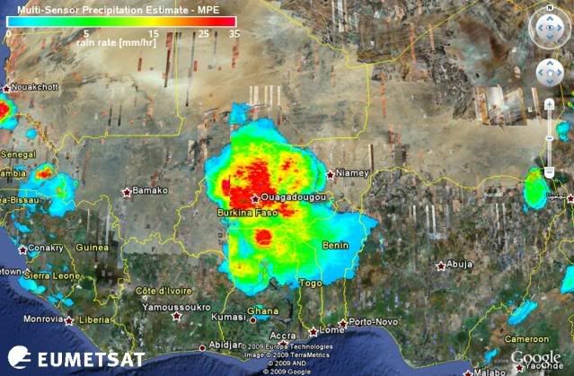
Re: Vigorous wave inside Africa
Current Weather Conditions:
Niamey-Aero, Niger
Niamey-Aero, Niger
Code: Select all
24 Hour Summary

   Time
EDT (UTC)    Temperature
F (C)    Dew Point
F (C)    Pressure
Inches (hPa)    Wind
MPH    Weather
Latest    7 PM (23) Aug 28    78 (26)    69 (21)    29.83 (1010)    SSE 9
   6 PM (22) Aug 28    78 (26)    71 (22)    29.80 (1009)    SSE 9
   5 PM (21) Aug 28    82 (28)    71 (22)    29.77 (1008)    SSE 12
   4 PM (20) Aug 28    86 (30)    77 (25)    29.74 (1007)    SSE 9
   3 PM (19) Aug 28    89 (32)    77 (25)    29.74 (1007)    S 7
   2 PM (18) Aug 28    91 (33)    73 (23)    29.71 (1006)    SSW 6
   1 PM (17) Aug 28    93 (34)    69 (21)    29.71 (1006)    SW 6
   Noon (16) Aug 28    95 (35)    69 (21)    29.71 (1006)    W 8
   11 AM (15) Aug 28    95 (35)    68 (20)    29.74 (1007)    W 8
   10 AM (14) Aug 28    96 (36)    69 (21)    29.74 (1007)    W 9
   9 AM (13) Aug 28    93 (34)    69 (21)    29.77 (1008)    WNW 10
   8 AM (12) Aug 28    95 (35)    71 (22)    29.80 (1009)    WNW 10
   7 AM (11) Aug 28    93 (34)    71 (22)    29.83 (1010)    W 10
   6 AM (10) Aug 28    91 (33)    71 (22)    29.83 (1010)    W 13
   5 AM (9) Aug 28    87 (31)    71 (22)    29.85 (1011)    W 14
   4 AM (8) Aug 28    84 (29)    73 (23)    29.85 (1011)    W 13
   3 AM (7) Aug 28    82 (28)    73 (23)    29.83 (1010)    W 8
   2 AM (6) Aug 28    80 (27)    73 (23)    29.80 (1009)    W 8
   1 AM (5) Aug 28    80 (27)    73 (23)    29.80 (1009)    W 8
   Midnight (4) Aug 28    80 (27)    73 (23)    29.80 (1009)    W 10
   11 PM (3) Aug 27    82 (28)    73 (23)    29.77 (1008)    W 10
   10 PM (2) Aug 27    80 (27)    73 (23)    29.80 (1009)    WSW 8
   9 PM (1) Aug 27    82 (28)    75 (24)    29.80 (1009)    WSW 6
Oldest    8 PM (0) Aug 27    82 (28)    75 (24)    29.83 (1010)    WSW 6
0 likes
-
Annie Oakley
- Category 5
- Posts: 1103
- Joined: Tue Jul 31, 2007 12:54 pm
- Location: Texas
-
HURAKAN
- Professional-Met
- Posts: 46084
- Age: 39
- Joined: Thu May 20, 2004 4:34 pm
- Location: Key West, FL
- Contact:
Re:
Annie Oakley wrote:Oh please interpret that weather stuff for us civilians lol! Honestly-I am curious what it must be like with that blast going through. In fact-we need to hear from weather enthusiasts in Africa!
This city was impacted in the last 24 hours by this system and reported west winds, which is very unusual for a city in the tropics that should normally get east winds except if there is a low pressure at the surface or local effects. Now, local effects typically don't last 12 hours or more. Also, the normal atmospheric pressure worldwide is 1013.25 mb and this city reported at one point 1006 mb, which is quite low. I just posted that information to show how interesting this system is.
0 likes
Who is online
Users browsing this forum: No registered users and 49 guests