Small low pressure in the eastern Atlantic

This is the general tropical discussion area. Anyone can take their shot at predicting a storms path.

Moderator: S2k Moderators

Forum rules

The posts in this forum are NOT official forecasts and should not be used as such. They are just the opinion of the poster and may or may not be backed by sound meteorological data. They are NOT endorsed by any professional institution or STORM2K. For official information, please refer to products from the National Hurricane Center and National Weather Service.

Help Support Storm2K
Message
Author
User avatar
HURAKAN
Professional-Met
Professional-Met
Posts: 46086
Age: 38
Joined: Thu May 20, 2004 4:34 pm
Location: Key West, FL
Contact:

Small low pressure in the eastern Atlantic

#1 Postby HURAKAN » Mon Oct 19, 2009 11:00 pm

Image

Loop: http://www.ssd.noaa.gov/goes/east/catl/flash-avn.html

TROPICAL WEATHER DISCUSSION
NWS TPC/NATIONAL HURRICANE CENTER MIAMI FL
805 PM EDT MON OCT 19 2009

...TROPICAL WAVES...

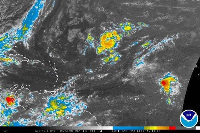
A QUASI STATIONARY 1010 MB LOW IS CENTERED NEAR 11N34.5W.
SATELLITE IMAGERY SHOWS A DISTINCT LOW LEVEL CENTER. THE LOW WAS
LEFT BEHIND BY THE TROPICAL WAVE AT 40W. ISOLATED MODERATE
CONVECTION IS FROM 9N-15N BETWEEN 31W-34W.
0 likes   

User avatar
HURAKAN
Professional-Met
Professional-Met
Posts: 46086
Age: 38
Joined: Thu May 20, 2004 4:34 pm
Location: Key West, FL
Contact:

#2 Postby HURAKAN » Mon Oct 19, 2009 11:01 pm

Image

Very strong shear
0 likes   

User avatar
HURAKAN
Professional-Met
Professional-Met
Posts: 46086
Age: 38
Joined: Thu May 20, 2004 4:34 pm
Location: Key West, FL
Contact:

#3 Postby HURAKAN » Mon Oct 19, 2009 11:02 pm

Image

Quite deep
0 likes   

User avatar
HURAKAN
Professional-Met
Professional-Met
Posts: 46086
Age: 38
Joined: Thu May 20, 2004 4:34 pm
Location: Key West, FL
Contact:

#4 Postby HURAKAN » Tue Oct 20, 2009 4:15 am

0 likes   


Return to “Talkin' Tropics”

Who is online

Users browsing this forum: Blown Away, cycloneye and 97 guests