Top hurricane sat photos of all time...
Moderator: S2k Moderators
Forum rules

The posts in this forum are NOT official forecasts and should not be used as such. They are just the opinion of the poster and may or may not be backed by sound meteorological data. They are NOT endorsed by any professional institution or STORM2K. For official information, please refer to products from the National Hurricane Center and National Weather Service.
-
cheezyWXguy

- Category 5

- Posts: 5528
- Joined: Mon Feb 13, 2006 12:29 am
- Location: Dallas, TX
-
beoumont

- Category 1

- Posts: 473
- Joined: Sun Jul 10, 2011 4:13 pm
- Location: East Central Florida
- Contact:
Re:
FireRat wrote:Andrew??
That is correct. In the SE Gulf of Mexico. Cat 4, 943 mb at the time.
0 likes
List of 79 tropical cyclones intercepted by Richard Horodner:
http://www.canebeard.com/page/page/572246.htm
http://www.canebeard.com/page/page/572246.htm

Re: Top hurricane sat photos of all time...
sweet!
do I get a prize?
just kidding!
do I get a prize?
just kidding!
0 likes
Georges '98, Irene '99, Frances '04, Jeanne '04, Katrina '05, Wilma '05, Gustav '08, Isaac '12, Matthew '16, Florence '18, Michael '18, Ian '22
-
beoumont
- Category 1
- Posts: 473
- Joined: Sun Jul 10, 2011 4:13 pm
- Location: East Central Florida
- Contact:
Re: Top hurricane sat photos of all time...
FireRat wrote:do I get a prize?
A free ride in my new chase vehicle into the great S. Florida hurricane of Sept. 9, 2011:

0 likes
List of 79 tropical cyclones intercepted by Richard Horodner:
http://www.canebeard.com/page/page/572246.htm
http://www.canebeard.com/page/page/572246.htm
-
Bad_Hurricane
- Tropical Depression

- Posts: 93
- Joined: Fri Jun 25, 2010 4:45 pm
- Location: Zagreb, Croatia
- Contact:


-
beoumont
- Category 1
- Posts: 473
- Joined: Sun Jul 10, 2011 4:13 pm
- Location: East Central Florida
- Contact:
Re: Top hurricane sat photos of all time...
Here's a couple more pics; not "spectacular" but unique:
1st, tropical disturbance "Nixon" in October, 1982. This pic. is NOT doctored.

And what I believe is Betsy in 1965.

1st, tropical disturbance "Nixon" in October, 1982. This pic. is NOT doctored.
And what I believe is Betsy in 1965.
0 likes
List of 79 tropical cyclones intercepted by Richard Horodner:
http://www.canebeard.com/page/page/572246.htm
http://www.canebeard.com/page/page/572246.htm
-
TreasureIslandFLGal

- S2K Supporter

- Posts: 1558
- Age: 56
- Joined: Sun Aug 15, 2004 6:16 pm
- Location: Clearwater, Florida ~3 miles from the coast now. We finally moved safely off the barrier island!
Re:
brunota2003 wrote:That first photo is not from any Hurricane.

This is just too cool of a pic.
[img]
Actually it was! It was a pic taken of an approaching band from Hurricane Isabelle.
0 likes
Chrissy & Ligeia
Chrissy & Nikki

Chrissy & Nikki
-
alan1961

- Category 2

- Posts: 767
- Joined: Mon Mar 20, 2006 11:58 am
- Location: Derby, Derbyshire, England
- Contact:
Re: Top hurricane sat photos of all time...
Ivanhater look away now...a classic from the space station 


0 likes
-
beoumont
- Category 1
- Posts: 473
- Joined: Sun Jul 10, 2011 4:13 pm
- Location: East Central Florida
- Contact:
Re: Re:
TreasureIslandFLGal wrote:brunota2003 wrote:That first photo is not from any Hurricane.
This is just too cool of a pic.
[img]
Actually it was! It was a pic taken of an approaching band from Hurricane Isabelle.
Just for debates sake:
There is a series of Great Plains supercell pictures that travels around the internet, shortly after each major hurricane; and for years afterward. They are obviously not hurricane pictures, but are always labeled "Spectacular photos of Hurricane ( ) as it approached shore." The e-mail is always titled something like, "My uncle's photos of Hurricane (Katrina, Isabel, Wilma, etc) just before his home was destroyed." or some-other supposed 2nd or 3rd hand accountl
Relatives and friends knowing I am a storm nut/enthusiast send me these "viral" sets of photos; and I will l get a half dozen of these e-mails, "sharing" these wonderful "hurricane" pictures with me after each hurricane ----that are actually Kansas or Nebraska supercells.
This shot looks like one of that series. Often they are shots stolen from Mike Hollingshead website.
So, I am asking the poster to try and identify the photographer or a real website of that striated supercell that is supposedly Isabel. I am not saying it is 100% sure it is not a hurricane picture, but I would bet 100-1 it is not. This is based on personally watching 75+ hurricanes and major tropical storms come ashore; Isabel being one of them. Never seen anything that resembles a striated supercell with a hurricane.
I see the pic. has Isabel printed along the bottom; but that tells nothing, really. Trying to be a detective, that structure to the left of the striated supercell appears to be a grain elevator and storage facility.
Doing a quick search for "storm front" as is posted on the picture, I get a plethora of references to other forums with posts noting that that very picture is fake. But I did not quickly find the actual photographer's site that took that pic.
Searching "Hurricane Isabel photos" that one comes up on several occasions; but ALWAYS on sites that do not identify the actual photographer or location.
Like I said: just for debate's sake; as such a cloud structure in a hurricane would be a "super rare" occurrence.
1 likes
List of 79 tropical cyclones intercepted by Richard Horodner:
http://www.canebeard.com/page/page/572246.htm
http://www.canebeard.com/page/page/572246.htm
-
brunota2003

- S2K Supporter
- Posts: 9476
- Age: 33
- Joined: Sat Jul 30, 2005 9:56 pm
- Location: Stanton, KY...formerly Havelock, NC
- Contact:
Re: Re:
TreasureIslandFLGal wrote:brunota2003 wrote:That first photo is not from any Hurricane.
This is just too cool of a pic.
[img]
Actually it was! It was a pic taken of an approaching band from Hurricane Isabelle.
I was living in NC when Isabel hit (was my 13th birthday! and my first ever hurricane). I can say with certainty that photo is not from Isabel.
Snopes take on it, and another photo that people claimed was from Isabel:
http://www.snopes.com/photos/natural/isabel.asp#photo
Also, the write up of Mark Sudduth's intercept of Isabel (with photos)
http://hurricanetrack.com/isabel2003.html
Another thing to note is that the majority (if not all) of the outer bands affected us during the night time hours...here is a radar loop showing us just entering the thick of things at 8 am:
http://tima.homeip.net/wxpics/MHXLongloopIsabel.gif
Last edited by brunota2003 on Mon Jul 25, 2011 1:55 pm, edited 1 time in total.
1 likes
-
Hurricane Jed

- Category 2
- Posts: 542
- Age: 36
- Joined: Mon Jan 24, 2011 3:36 pm
- Location: Cen Tex
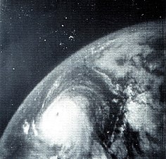
http://upload.wikimedia.org/wikipedia/c ... _Betsy.jpg
This my favorite. I'm pretty sure the white spots in the background are just from the grainy quality but I think a few could be stars.
This my favorite. I'm pretty sure the white spots in the background are just from the grainy quality but I think a few could be stars.
0 likes
-
beoumont
- Category 1
- Posts: 473
- Joined: Sun Jul 10, 2011 4:13 pm
- Location: East Central Florida
- Contact:
Re: Re:
brunota2003 wrote:[\
I was living in NC when Isabel hit (was my 13th birthday! and my first ever hurricane). I can say with certainty that photo is not from Isabel.
Snopes take on it, and another photo that people claimed was from Isabel:
http://www.snopes.com/photos/natural/isabel.asp#photo
Also, the write up of Mark Sudduth's intercept of Isabel (with photos)
http://hurricanetrack.com/isabel2003.html
Another thing to note is that the majority (if not all) of the outer bands affected us during the night time hours...here is a radar loop showing us just entering the thick of things at 8 am:
http://tima.homeip.net/wxpics/MHXLongloopIsabel.gif
That Snopes picture is clearer, and the grain elevator appears more likely to be just that.
And similarly, we spent the night before at Sneads Ferry, on the coast, hoping for landfall there. First light revealed a multi layered cloud deck; which would make a supercell with striations impossible to see, if it really existed. Just as you noted, the outer bands came in overnight.
Personally, when the landfall point seemed further north, we started towards Hatteras in the morning, but after learning from Recon. that the strongest echos and wind, just before landfall, were developing on the NW side, we decided to go to Elizabeth City, where those echos were likely to pass. I also recalled that Hazel, 1954, sent destructive surge up those rivers on the north side of the Sounds.
Adding to Mark Suddeth's account, below is a short video of what we encountered at Elizabeth City, which included an 8 foot surge and gusts right around 100 mph. Post storm surveys showed the highest wind path was just west of there, and east of Edenton, NC.
The video contains some excellent satellite loops of Isabel, making this post somewhat on-topic.
[youtube]http://www.youtube.com/watch?v=hn0FyXxxweQ[/youtube]
0 likes
List of 79 tropical cyclones intercepted by Richard Horodner:
http://www.canebeard.com/page/page/572246.htm
http://www.canebeard.com/page/page/572246.htm
Re: Re:
beoumont wrote:TreasureIslandFLGal wrote:brunota2003 wrote:That first photo is not from any Hurricane.
This is just too cool of a pic.
[img]
Actually it was! It was a pic taken of an approaching band from Hurricane Isabelle.
Just for debates sake:
There is a series of Great Plains supercell pictures that travels around the internet, shortly after each major hurricane; and for years afterward. They are obviously not hurricane pictures, but are always labeled "Spectacular photos of Hurricane ( ) as it approached shore." The e-mail is always titled something like, "My uncle's photos of Hurricane (Katrina, Isabel, Wilma, etc) just before his home was destroyed." or some-other supposed 2nd or 3rd hand accountl
Relatives and friends knowing I am a storm nut/enthusiast send me these "viral" sets of photos; and I will l get a half dozen of these e-mails, "sharing" these wonderful "hurricane" pictures with me after each hurricane ----that are actually Kansas or Nebraska supercells.
This shot looks like one of that series. Often they are shots stolen from Mike Hollingshead website.
So, I am asking the poster to try and identify the photographer or a real website of that striated supercell that is supposedly Isabel. I am not saying it is 100% sure it is not a hurricane picture, but I would bet 100-1 it is not. This is based on personally watching 75+ hurricanes and major tropical storms come ashore; Isabel being one of them. Never seen anything that resembles a striated supercell with a hurricane.
I see the pic. has Isabel printed along the bottom; but that tells nothing, really. Trying to be a detective, that structure to the left of the striated supercell appears to be a grain elevator and storage facility.
Doing a quick search for "storm front" as is posted on the picture, I get a plethora of references to other forums with posts noting that that very picture is fake. But I did not quickly find the actual photographer's site that took that pic.
Searching "Hurricane Isabel photos" that one comes up on several occasions; but ALWAYS on sites that do not identify the actual photographer or location.
Like I said: just for debate's sake; as such a cloud structure in a hurricane would be a "super rare" occurrence.
Not to pile on, but you might be interested in the image-searching tool TinEye. You can upload an image and it finds matches around the web. It is great for tracing the origins of stuff like this: http://www.tineye.com/search/1110e3b95340cea834a45d31ee43945a1740ca4b/?pluginver=firefox-1.1
0 likes
Eyes: Emily '86, Dean '89, Felix '95, Gert '99, Fabian '03, Humberto '19, Paulette '20
-
beoumont
- Category 1
- Posts: 473
- Joined: Sun Jul 10, 2011 4:13 pm
- Location: East Central Florida
- Contact:
Re: Top hurricane sat photos of all time...
Typhoon Yuri - 895 mb., 1991, 175 mph., from Space Shuttle.

0 likes
List of 79 tropical cyclones intercepted by Richard Horodner:
http://www.canebeard.com/page/page/572246.htm
http://www.canebeard.com/page/page/572246.htm
-
beoumont
- Category 1
- Posts: 473
- Joined: Sun Jul 10, 2011 4:13 pm
- Location: East Central Florida
- Contact:
Re: Top hurricane sat photos of all time...
Came across a couple of shots from Hugo, 1989 when he was a cat 5, 918 mb. east of the Lesser Antilles:


0 likes
List of 79 tropical cyclones intercepted by Richard Horodner:
http://www.canebeard.com/page/page/572246.htm
http://www.canebeard.com/page/page/572246.htm

Re: Top hurricane sat photos of all time...
I'd post if I had one, but I am sure someone has to have that very menacing shot of Hurricane Luis approaching the eastern Caribbean in 1995. I remember that the storm had a very large area of hurricane force winds.
0 likes
-
HurricaneBill
- Category 5
- Posts: 3420
- Joined: Sun Apr 11, 2004 5:51 pm
- Location: East Longmeadow, MA, USA
Re: Top hurricane sat photos of all time...
EDR1222 wrote:I'd post if I had one, but I am sure someone has to have that very menacing shot of Hurricane Luis approaching the eastern Caribbean in 1995. I remember that the storm had a very large area of hurricane force winds.
Is this it?

0 likes
Re: Top hurricane sat photos of all time...
Yes HurricaneBill...that is the one. Thanks for posting !
0 likes
Re: Top hurricane sat photos of all time...
This has to be my favorite when it comes to beauty (not to mention I was at the NHC when it was taken of Hurricane Elena, just west of Tampa):
http://www.freebase.com/view/wikipedia/ ... id/1054501
http://www.freebase.com/view/wikipedia/ ... id/1054501
0 likes
-
floridasun78
- Category 5
- Posts: 3755
- Joined: Sun May 17, 2009 10:16 pm
- Location: miami fl
Re: Top hurricane sat photos of all time...
ty you all posting hurr pic past hurr i have one of kartina before south fl landfall i will post later this topic was cool idea that we not thing track now maybe for week
0 likes