Reanalysis questions

This is the general tropical discussion area. Anyone can take their shot at predicting a storms path.

Moderator: S2k Moderators

Forum rules

The posts in this forum are NOT official forecasts and should not be used as such. They are just the opinion of the poster and may or may not be backed by sound meteorological data. They are NOT endorsed by any professional institution or STORM2K. For official information, please refer to products from the National Hurricane Center and National Weather Service.

Help Support Storm2K
Message
Author
CrazyC83
Professional-Met
Professional-Met
Posts: 33393
Joined: Tue Mar 07, 2006 11:57 pm
Location: Deep South, for the first time!

Re: Reanalysis questions

#21 Postby CrazyC83 » Wed Apr 11, 2012 3:55 pm

StormClouds63 wrote:http://www.aoml.noaa.gov/hrd/Landsea/12Tides.pdf

Read the summary on the 1935 Labor Day Hurricane chapter. It says that the Labor Day storm was easily a "category 6" hurricane if the SS scale included such a ranking.

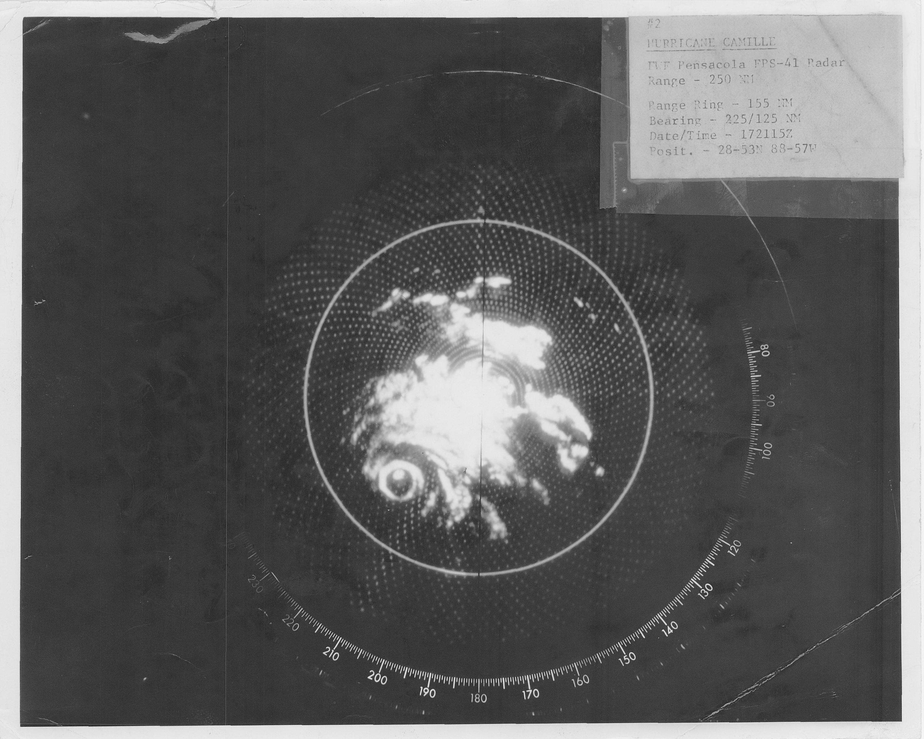
I believe the most anticipated reanalysis yet to come is on Camille (1969). Will it stay a category 5? I ask that question based on the following:

http://ldctstormchaser.blogspot.com/2010/08/hurricane-camille-41-years-later.html
http://www.aoml.noaa.gov/hrd/Storm_pages/camille1969/wind.html


I took a look at Camille, used all the relationships to estimate. Based on the Brown et al P/W relationship, the winds for a 909mb pressure at steady state north of 25N would be 141 kt and for a weakening storm would be 135 kt. Size was medium and speed was near what would normally be expected there, so no adjustments need to be made. I couldn't find any uber-extreme wind reports on land that were legitimate sustained reports (nothing beyond what would normally be expected in a major hurricane landfall), so I would put the landfall intensity at 135 kt. There were no recon wind reports in the time, but the only flight-level wind report - when the storm was way out in the Gulf - was 165 kt (supports 150 kt) at the time of the 901mb pressure, which I believe was legitimate. P/W relationships for 901mb also balance out to about 150 kt.

Peak intensity is problematic - there was a significant gap in recon coverage, and an assumption could be made that Camille peaked in that period (905mb followed 18 hours later by 901mb). However, there is no proof of that. The peak intensity would be 150 kt if no assumption was made, and 155 kt if one could be made.

http://scholarlyrepository.miami.edu/cg ... =oa_theses for the relationships (starting on page 165)
If
0 likes   

StormClouds63
Category 2
Category 2
Posts: 583
Age: 60
Joined: Tue May 13, 2008 11:56 am
Location: Southwest Louisiana

Re: Reanalysis questions

#22 Postby StormClouds63 » Wed Apr 11, 2012 4:52 pm

CrazyC83:

Thanks for the information on Camille. Maximum sustained winds at landfall in the 155-165 mph makes sense. I've read in some sources that recon wind estimates prior to 1970 often over-estimated maximum sustained winds. I was surprised several years ago that wind speeds of Audrey (1957) were only in the category 1 range, but the maximum wind radius was quite large ... thus accounting for storm surge that occurred.
0 likes   

HurricaneBill
Category 5
Category 5
Posts: 3420
Joined: Sun Apr 11, 2004 5:51 pm
Location: East Longmeadow, MA, USA

Re: Reanalysis questions

#23 Postby HurricaneBill » Wed Apr 11, 2012 7:29 pm

I'm interested in Inez in 1966. I heard flight level winds easily supported Category 5.
0 likes   

User avatar
MGC
S2K Supporter
S2K Supporter
Posts: 5792
Joined: Sun Mar 23, 2003 9:05 pm
Location: Pass Christian MS, or what is left.

Re: Reanalysis questions

#24 Postby MGC » Wed Apr 11, 2012 7:32 pm

I noticed the HRD reanalysis of Camille a few years ago. I still believe Camille was a Cat-5 considering the 909mb pressure measured and verified in the eye at landfall. The barometer used to measure the 909mb pressure was sent in for verification after the hurricane. Personally, I think Camille was bombing at the time the last measurment was made by the Air Force at 901mb. A later Navy flight aborted its penetration because of severe turbulance and a another mission aborted due to equipment failure. I would not be surprised that Camille was actually sub 900mb as the hurricane approached the Louisiana coast. Camille likely started to weaken as the hurricane approched the mouth of the Mississippi due to reduced ocean heat content. I have seen the radar picture of Camille and it had an intact eyewall that had not eroded like Katrina and Ivan. People I have talked to here on the Mississippi Coast especially those where both hurricanes made landfall (Hancock County) have all said that Camille had much stronger winds than Katrina, but Katrina's winds lasted way longer. Speaking of Wilma, I talked to a Hurricane Hunter that flew Wilma while the hurricane was in RI mode and he said it was a very turbulent ride and they considered aborting the penetration. He said the eye was so small they had a hard time staying it the eye......MGC
0 likes   

CrazyC83
Professional-Met
Professional-Met
Posts: 33393
Joined: Tue Mar 07, 2006 11:57 pm
Location: Deep South, for the first time!

Re: Reanalysis questions

#25 Postby CrazyC83 » Wed Apr 11, 2012 10:18 pm

MGC wrote:I noticed the HRD reanalysis of Camille a few years ago. I still believe Camille was a Cat-5 considering the 909mb pressure measured and verified in the eye at landfall. The barometer used to measure the 909mb pressure was sent in for verification after the hurricane. Personally, I think Camille was bombing at the time the last measurment was made by the Air Force at 901mb. A later Navy flight aborted its penetration because of severe turbulance and a another mission aborted due to equipment failure. I would not be surprised that Camille was actually sub 900mb as the hurricane approached the Louisiana coast. Camille likely started to weaken as the hurricane approched the mouth of the Mississippi due to reduced ocean heat content. I have seen the radar picture of Camille and it had an intact eyewall that had not eroded like Katrina and Ivan. People I have talked to here on the Mississippi Coast especially those where both hurricanes made landfall (Hancock County) have all said that Camille had much stronger winds than Katrina, but Katrina's winds lasted way longer. Speaking of Wilma, I talked to a Hurricane Hunter that flew Wilma while the hurricane was in RI mode and he said it was a very turbulent ride and they considered aborting the penetration. He said the eye was so small they had a hard time staying it the eye......MGC


The known data for Camille from all flights are (my guess for the intensity on that flight):

14 / 1440Z: 999mb (55 kt, genesis at 1200Z with 50 kt - probably was an intense wave beforehand)
15 / 0045Z: 991mb (70 kt)
15 / 1232Z: 969mb (100 kt, bombed out before Cuban landfall)
15 / 1519Z: 964mb (105 kt)
15 / 1820Z: 966mb (however, eye closed up between the 964 and 966 and the eye shrank a bit more so that seems unlikely - I would estimate the pressure at Cuban landfall was 962mb with an intensity of 105 kt)
16 / 1843Z: 908mb (145 kt, BOMBED BIG TIME after leaving Cuba, it likely held its strength or only slightly weakened then exploded on the 16th)
17 / 0016Z: 905mb (150 kt, strengthening slowed down)
17 / 1815Z: 901mb (150 kt, eye smaller than at 0016Z but the gap suggests it might have been stronger near 0600Z or 1200Z? Cannot be proven though; likely dropped to 140 kt at 0000Z)
18 / 0330Z: 909mb surface (135 kt)
0 likes   

User avatar
MGC
S2K Supporter
S2K Supporter
Posts: 5792
Joined: Sun Mar 23, 2003 9:05 pm
Location: Pass Christian MS, or what is left.

Re: Reanalysis questions

#26 Postby MGC » Thu Apr 12, 2012 10:14 am

What really bothers me about Camille and the lack of recon.....there were additional aircraft available but they were busy flying recon for project storm fury I believe. Imagine if Camille were to happen today and no recon?.....MGC
0 likes   

CrazyC83
Professional-Met
Professional-Met
Posts: 33393
Joined: Tue Mar 07, 2006 11:57 pm
Location: Deep South, for the first time!

#27 Postby CrazyC83 » Tue Apr 17, 2012 1:02 pm

Also, my best guess is that the west eyewall clipped the extreme southeast part of Louisiana, with the eye center remaining over water at around 17/2200-2300Z. At that time, the winds were likely near 145 kt, but those winds were only over water. In HURDAT, it would likely be best to put MS4, LA3 (guessing Cat 3 conditions were felt in that eyewall over those islands; New Orleans only saw Cat 1 conditions in the eastern part and tropical storm conditions in the western part it appears)
0 likes   

StormClouds63
Category 2
Category 2
Posts: 583
Age: 60
Joined: Tue May 13, 2008 11:56 am
Location: Southwest Louisiana

Re: Reanalysis questions

#28 Postby StormClouds63 » Tue Apr 17, 2012 4:22 pm

NHC archives radar image shows what looks like a double eye wall:
http://www.nhc.noaa.gov/archive/storm_wallets/cdmp/dvd0003-jpg/1969/atlantic/camille/radarpic/r0817.01.jpg

Perhaps eye wall replacement cycle was beginning as the storm was about 5-6 hours from Mississippi landfall?
0 likes   

User avatar
brunota2003
S2K Supporter
S2K Supporter
Posts: 9476
Age: 33
Joined: Sat Jul 30, 2005 9:56 pm
Location: Stanton, KY...formerly Havelock, NC
Contact:

#29 Postby brunota2003 » Tue Apr 17, 2012 6:26 pm

Perhaps...that would help explain why the winds might have been lower than you'd think they would be for a 909 pressure.
0 likes   

User avatar
MGC
S2K Supporter
S2K Supporter
Posts: 5792
Joined: Sun Mar 23, 2003 9:05 pm
Location: Pass Christian MS, or what is left.

Re: Reanalysis questions

#30 Postby MGC » Wed Apr 18, 2012 11:15 pm

Camille was not having an eyewall replacement cycle at landfall. Winds in Biloxi at Keesler AFB only maxed out at about 81mph sustained about 25 miles from eye landfall. Camille had a pretty tight pressure gradient and a very small area of extreme winds like Hurricane Charley did.......MGC
0 likes   

CrazyC83
Professional-Met
Professional-Met
Posts: 33393
Joined: Tue Mar 07, 2006 11:57 pm
Location: Deep South, for the first time!

#31 Postby CrazyC83 » Fri Apr 27, 2012 8:49 pm

1931-35 are complete based on HURDAT, but no announcement yet.

http://www.aoml.noaa.gov/hrd/hurdat/tra ... eanal.html
0 likes   

CrazyC83
Professional-Met
Professional-Met
Posts: 33393
Joined: Tue Mar 07, 2006 11:57 pm
Location: Deep South, for the first time!

#32 Postby CrazyC83 » Fri Apr 27, 2012 9:25 pm

Some highlights:

* 1931 Belize hurricane: upgraded to Cat 4 (peripheral pressure 952mb, central pressure ~945mb most likely)

* 1932 Cuba hurricane: upgraded to Cat 5, 150 kt (first in November), awaiting metadata but pressure likely ~905mb)

* Two Cat 5 hurricanes in 1933

* 1935 Labor Day hurricane: upgraded to 160 kt based on the 892mb pressure (even that might be conservative?)
0 likes   

User avatar
HURAKAN
Professional-Met
Professional-Met
Posts: 46086
Age: 37
Joined: Thu May 20, 2004 4:34 pm
Location: Key West, FL
Contact:

#33 Postby HURAKAN » Fri Apr 27, 2012 10:17 pm

People are reading, I like that!
0 likes   

User avatar
Cainer
Tropical Storm
Tropical Storm
Posts: 188
Age: 33
Joined: Mon May 05, 2008 3:26 pm
Location: Yarmouth, Nova Scotia

#34 Postby Cainer » Sun Apr 29, 2012 12:23 am

I'd also like to point out that the 1932 Cuba hurricane spent 78 consecutive hours as a Category 5 from November 5-8, beating Allen's record of 72 non-consecutive hours for the Atlantic storm that spent the most time as a Category 5. Pretty impressive for the only November Cat 5 on record!
0 likes   

User avatar
Ptarmigan
Category 5
Category 5
Posts: 5273
Joined: Wed Aug 16, 2006 9:06 pm

Re:

#35 Postby Ptarmigan » Sun Apr 29, 2012 2:24 pm

HURAKAN wrote:People are reading, I like that!


Re-Analysis is very interesting. Some seasons are more active than previously thought. I notice the number of major hurricanes and ACE have dropped through re-analysis. Yet, the total number of storms goes up.
0 likes   

User avatar
Ptarmigan
Category 5
Category 5
Posts: 5273
Joined: Wed Aug 16, 2006 9:06 pm

Re: Reanalysis questions

#36 Postby Ptarmigan » Sun Apr 29, 2012 2:32 pm

MGC wrote:Camille was not having an eyewall replacement cycle at landfall. Winds in Biloxi at Keesler AFB only maxed out at about 81mph sustained about 25 miles from eye landfall. Camille had a pretty tight pressure gradient and a very small area of extreme winds like Hurricane Charley did.......MGC


Camille had hurricane force winds extending up to 60 miles if I recall.

ftp://ftp.aoml.noaa.gov/hrd/pub/hwind/P ... tour08.png
0 likes   

CrazyC83
Professional-Met
Professional-Met
Posts: 33393
Joined: Tue Mar 07, 2006 11:57 pm
Location: Deep South, for the first time!

#37 Postby CrazyC83 » Sun Apr 29, 2012 4:42 pm

http://www.aoml.noaa.gov/hrd/hurdat/metadata_1932.html

The 1932 hurricane had a PERIPHERAL pressure of 915 mb with hurricane winds at the time. That means the central pressure was 908 mb or lower (not sure how low). My guess is about 900-905 at the time, a blend of the data would be 902 mb. At Cuban landfall, the pressure was 918 mb, with winds of 130 kt (which they mention might be a bit high).

Even if 908 mb was the central pressure (the absolute maximum possible), it would be the 10th strongest storm of all time. At 902 mb (my best guess after reading all the details), it would be tied for the 6th strongest storm.
0 likes   

CrazyC83
Professional-Met
Professional-Met
Posts: 33393
Joined: Tue Mar 07, 2006 11:57 pm
Location: Deep South, for the first time!

#38 Postby CrazyC83 » Sun Apr 29, 2012 5:25 pm

Some other highlights:

The first 1933 Cat 5 (Storm 11 - the Brownsville storm) had that based on a ship pressure of 930mb with hurricane conditions - probably a pressure near 922mb at the time.

The second 1933 Cat 5 (Storm 15) had that based on a ship pressure of 929mb in what was a small storm.
0 likes   

User avatar
Hurricane Jed
Category 2
Category 2
Posts: 542
Age: 36
Joined: Mon Jan 24, 2011 3:36 pm
Location: Cen Tex

#39 Postby Hurricane Jed » Mon Apr 30, 2012 12:57 pm

This is pretty impressive. 1930's now tied with the 1960's, each having 6 Category 5's. I'm pretty surprised 1933 had Category 5's. Wasn't expecting that one.
0 likes   

User avatar
Hurricane Jed
Category 2
Category 2
Posts: 542
Age: 36
Joined: Mon Jan 24, 2011 3:36 pm
Location: Cen Tex

#40 Postby Hurricane Jed » Wed May 02, 2012 9:58 pm

So 1933 actually lost a storm?
0 likes   


Return to “Talkin' Tropics”

Who is online

Users browsing this forum: Lizzytiz1, NotSparta and 187 guests