2. DISORGANIZED CLOUDINESS AND SHOWERS OVER THE CENTRAL AND
NORTHWESTERN BAHAMAS AND ADJACENT WESTERN ATLANTIC WATERS ARE
ASSOCIATED WITH A SURFACE TROUGH. STRONG UPPER-LEVEL WINDS ARE
LIKELY TO PREVENT ANY SIGNIFICANT DEVELOPMENT FOR THE NEXT DAY OR
TWO. THIS SYSTEM HAS A LOW CHANCE...10 PERCENT...OF BECOMING A
TROPICAL CYCLONE DURING THE NEXT 48 HOURS AS IT MOVES TO THE
NORTHWEST AT 5 TO 10 MPH.
Disturbance near Bahamas (is INVEST 91L)
Moderator: S2k Moderators
Forum rules

The posts in this forum are NOT official forecasts and should not be used as such. They are just the opinion of the poster and may or may not be backed by sound meteorological data. They are NOT endorsed by any professional institution or STORM2K. For official information, please refer to products from the National Hurricane Center and National Weather Service.
-
tolakram
- Admin

- Posts: 20179
- Age: 62
- Joined: Sun Aug 27, 2006 8:23 pm
- Location: Florence, KY (name is Mark)
Disturbance near Bahamas (is INVEST 91L)
0 likes
M a r k
- - - - -
Join us in chat: Storm2K Chatroom Invite. Android and IOS apps also available.
The posts in this forum are NOT official forecasts and should not be used as such. Posts are NOT endorsed by any professional institution or STORM2K.org. For official information and forecasts, please refer to NHC and NWS products.

Why do the Tropics have to get so active right when I start my vacation, lol.
This area of disturbance east of FL is the tropical wave ahead of Ernesto that we were tracking for days. It now has a nice vorticity just south Andros Island in the Bahamas as seen on HR vis sat loop this morning, still under a lot of shear but as it gets closer to the UL trough over FL it could find better environment for development. I have to keep an eye on since I am in South Beach vacationing.
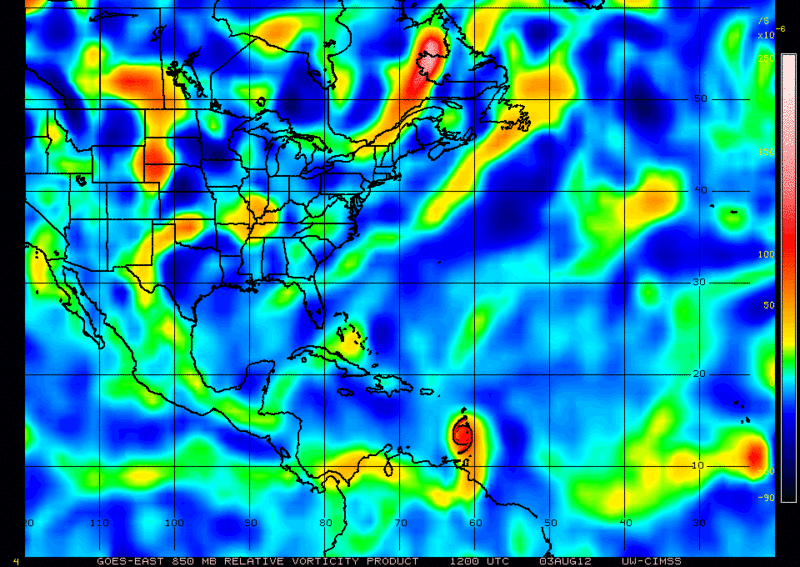
This area of disturbance east of FL is the tropical wave ahead of Ernesto that we were tracking for days. It now has a nice vorticity just south Andros Island in the Bahamas as seen on HR vis sat loop this morning, still under a lot of shear but as it gets closer to the UL trough over FL it could find better environment for development. I have to keep an eye on since I am in South Beach vacationing.
0 likes

Re: Disturbance near Bahamas (10%)
Is it August yet?

0 likes
The following post is NOT an official forecast and should not be used as such. It is just the opinion of the poster and may or may not be backed by sound meteorological data. It is NOT endorsed by any professional institution including storm2k.org For Official Information please refer to the NHC and NWS products.
-
Blown Away

- S2K Supporter

- Posts: 10253
- Joined: Wed May 26, 2004 6:17 am
Re: Disturbance near Bahamas (10%)

0 likes
Hurricane Eye Experience: David 79, Irene 99, Frances 04, Jeanne 04, Wilma 05… Hurricane Brush Experience: Andrew 92, Erin 95, Floyd 99, Matthew 16, Irma 17, Ian 22, Nicole 22…
-
Bocadude85

- Category 5

- Posts: 2991
- Age: 39
- Joined: Mon Apr 18, 2005 2:20 pm
- Location: Honolulu,Hi
Re: Disturbance near Bahamas (10%)
Last nights Euro tried to spin this up before making landfall in east cental florida.
0 likes
-
Bocadude85
- Category 5
- Posts: 2991
- Age: 39
- Joined: Mon Apr 18, 2005 2:20 pm
- Location: Honolulu,Hi
Re: Disturbance near Bahamas (10%)
Recon has been scheduled.
000
NOUS42 KNHC 031409
REPRPD
WEATHER RECONNAISSANCE FLIGHTS
CARCAH, NATIONAL HURRICANE CENTER, MIAMI, FL.
1015 AM EDT FRI 03 AUGUST 2012
SUBJECT: TROPICAL CYCLONE PLAN OF THE DAY (TCPOD)
VALID 04/1100Z TO 05/1100Z AUGUST 2012
TCPOD NUMBER.....12-077
I. ATLANTIC REQUIREMENTS
1. TROPICAL STORM ERNESTO
FLIGHT ONE -TEAL 70- FLIGHT TWO -TEAL 71-
A. 04/1200, 1800Z A. 05/0000Z, 0600Z
B. AFXXX 0405A ERNESTO B. AFXXX 0505A ERNESTO
C. 04/1030Z C. 04/2200Z
D. 14.4N 68.1W D. 15.0N 71.2W
E. 04/1130Z TO 04/1800Z E. 04/2330Z TO 05/0600Z
F. SFC TO 10,000 FT F. SFC TO 10,000 FT
2. OUTLOOK FOR SUCCEEDING DAY: CONTINUE 6-HRLY FIXES.
3. REMARKS: BECAUSE OF THE STORM'S LOCATION AND FOR MORE
FAVORABLE CREW SEQUENCING, TODAY'S FIX FOR 03/1800Z
HAS BEEN SLIPPED TO 03/2200Z AND THE 04/0600Z
REQUIREMENT HAS BEEN CANCELED.
4. SUSPECT AREA (OFF EAST COAST OF FLORIDA)
FLIGHT ONE -TEAL 73-
A. 04/1900Z
B. AFXXX 01BBA INVEST
C. 04/1700Z
D. 28.0N 80.0W
E. 04/1830Z TO 04/2130Z
F. SFC TO 10,000 FT
5. SUCCEEDING DAY OUTLOOK.....NEGATIVE.
II. PACIFIC REQUIREMENTS
1. NEGATIVE RECONNAISSANCE REQUIREMENTS.
2. OUTLOOK FOR SUCCEEDING DAY.....NEGATIVE.
$$
0 likes
-
Pearl River

- S2K Supporter
- Posts: 825
- Age: 66
- Joined: Fri Dec 09, 2005 6:07 pm
- Location: SELa
Re: Disturbance near Bahamas (10%)
If I'm not mistaken, I believe this is the one the NOGAPS was sending across Fl into the coast of La, then SW towards the Rio Grande Valley.
0 likes


Re: Disturbance near Bahamas (10%)
Will this systm have effect on Ernesto - once it crosses Fl and gets in Gulf?
0 likes
-
gatorcane

- S2K Supporter
- Posts: 23708
- Age: 48
- Joined: Sun Mar 13, 2005 3:54 pm
- Location: Boca Raton, FL
Re: Disturbance near Bahamas (10%)
Pearl River wrote:If I'm not mistaken, I believe this is the one the NOGAPS was sending across Fl into the coast of La, then SW towards the Rio Grande Valley.
Yes the 18Z NOGAPs develops this and moves it NW towards Florida. Not much more model support than that tough, however, certainly looks interesting.
If it manages to develop into something, I would think it could influence the track of Ernesto, but at this time the chances are low that would happen.
0 likes
-
floridasun78
- Category 5
- Posts: 3755
- Joined: Sun May 17, 2009 10:16 pm
- Location: miami fl
-
tolakram
- Admin
- Posts: 20179
- Age: 62
- Joined: Sun Aug 27, 2006 8:23 pm
- Location: Florence, KY (name is Mark)
Re: Disturbance near Bahamas (10%)
Is now Invest 91L viewtopic.php?f=59&t=113224
0 likes
M a r k
- - - - -
Join us in chat: Storm2K Chatroom Invite. Android and IOS apps also available.
The posts in this forum are NOT official forecasts and should not be used as such. Posts are NOT endorsed by any professional institution or STORM2K.org. For official information and forecasts, please refer to NHC and NWS products.
- - - - -
Join us in chat: Storm2K Chatroom Invite. Android and IOS apps also available.
The posts in this forum are NOT official forecasts and should not be used as such. Posts are NOT endorsed by any professional institution or STORM2K.org. For official information and forecasts, please refer to NHC and NWS products.
Who is online
Users browsing this forum: Google [Bot] and 154 guests