2014 EPAC Season

This is the general tropical discussion area. Anyone can take their shot at predicting a storms path.

Moderator: S2k Moderators

Forum rules

The posts in this forum are NOT official forecasts and should not be used as such. They are just the opinion of the poster and may or may not be backed by sound meteorological data. They are NOT endorsed by any professional institution or STORM2K. For official information, please refer to products from the National Hurricane Center and National Weather Service.

Help Support Storm2K
Message
Author
User avatar
Yellow Evan
Professional-Met
Professional-Met
Posts: 15955
Age: 25
Joined: Fri Jul 15, 2011 12:48 pm
Location: Henderson, Nevada/Honolulu, HI
Contact:

Re:

#581 Postby Yellow Evan » Fri Jun 27, 2014 9:04 pm

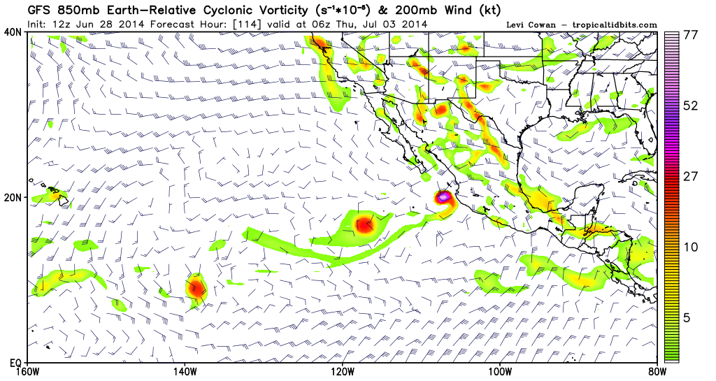
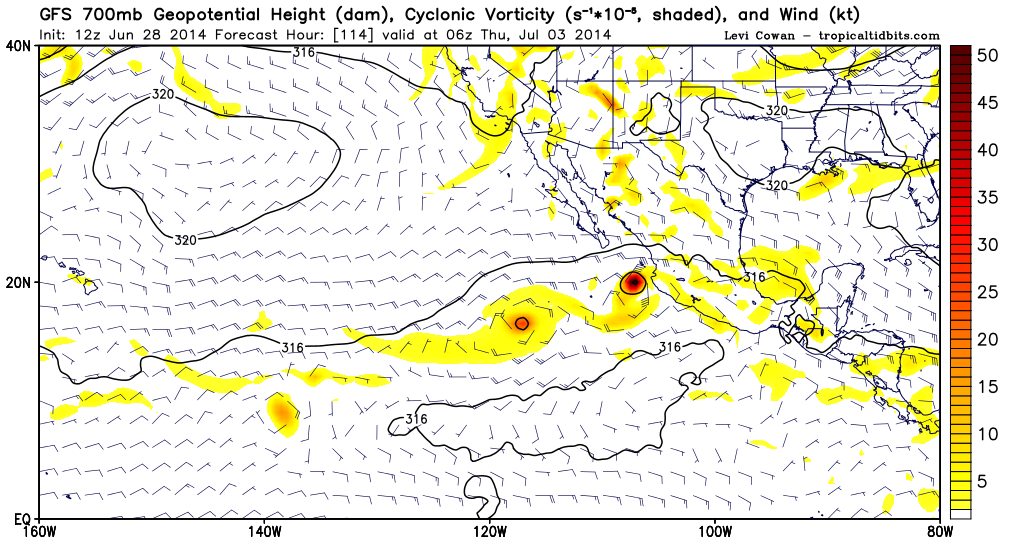
Kingarabian wrote:What I see with this setup in regards to those two invests, is a reminisce of Felicia and Enrique in 2009. Of course these two systems are further East.

Of course one of these systems are going to have to give to the other. I see one storm becoming dominant and the other mediocre. Doubt they collectively become strong together.

The posts in this forum are NOT official forecast and should not be used as such. They are just the opinion of the poster and may or may not be backed by sound meteorological data. They are NOT endorsed by any professional institution or storm2k.org. For official information, please refer to the NHC and NWS products.[td100]


Good comparison, though they are a bunch I could name like those. I agree one will be weak and the other will be strong. I'm leaning towards 96E dominating.
0 likes   

User avatar
Yellow Evan
Professional-Met
Professional-Met
Posts: 15955
Age: 25
Joined: Fri Jul 15, 2011 12:48 pm
Location: Henderson, Nevada/Honolulu, HI
Contact:

#582 Postby Yellow Evan » Sat Jun 28, 2014 12:48 am

A large area of cloudiness and disorganized showers extends
several hundred miles south of Central America and southeastern
Mexico. Development of this system, if any, should be slow to occur
while it moves west-northwestward at 10 to 15 mph.
* Formation chance through 48 hours...low...10 percent.
* Formation chance through 5 days...low...20 percent.
0 likes   

User avatar
cycloneye
Admin
Admin
Posts: 139191
Age: 67
Joined: Thu Oct 10, 2002 10:54 am
Location: San Juan, Puerto Rico

Re: 2014 EPAC Season

#583 Postby cycloneye » Sat Jun 28, 2014 7:08 am

A large area of cloudiness and disorganized showers extends
several hundred miles south of Central America and southeastern
Mexico. Some slow development of this system is possible over the
next few days while it moves west-northwestward at 10 to 15 mph.
* Formation chance through 48 hours...low...20 percent.
* Formation chance through 5 days...medium...30 percent.
0 likes   
Visit the Caribbean-Central America Weather Thread where you can find at first post web cams,radars
and observations from Caribbean basin members Click Here

User avatar
Yellow Evan
Professional-Met
Professional-Met
Posts: 15955
Age: 25
Joined: Fri Jul 15, 2011 12:48 pm
Location: Henderson, Nevada/Honolulu, HI
Contact:

#584 Postby Yellow Evan » Sat Jun 28, 2014 9:59 am

GFS doesn't show this anymore but does show Elida by around day 12.
0 likes   

User avatar
srainhoutx
S2K Supporter
S2K Supporter
Posts: 6919
Age: 66
Joined: Sun Jan 14, 2007 11:34 am
Location: Haywood County, NC
Contact:

Re:

#585 Postby srainhoutx » Sat Jun 28, 2014 11:13 am

Yellow Evan wrote:GFS doesn't show this anymore but does show Elida by around day 12.


Actually the current outlined area ESE of 96E does develop and is very compact and may pose more of a threat for rapid development as 96E drifts out to sea and never really develops.

Image

Image
0 likes   
Carla/Alicia/Jerry(In The Eye)/Michelle/Charley/Ivan/Dennis/Katrina/Rita/Wilma/Ike/Harvey

Member: National Weather Association
Wx Infinity Forums
http://wxinfinity.com/index.php

Facebook.com/WeatherInfinity
Twitter @WeatherInfinity

User avatar
Yellow Evan
Professional-Met
Professional-Met
Posts: 15955
Age: 25
Joined: Fri Jul 15, 2011 12:48 pm
Location: Henderson, Nevada/Honolulu, HI
Contact:

Re: 2014 EPAC Season

#586 Postby Yellow Evan » Sat Jun 28, 2014 11:34 am

Image

:uarrow: It's back on the 12z run

Image

Elida near Baja
0 likes   

User avatar
cycloneye
Admin
Admin
Posts: 139191
Age: 67
Joined: Thu Oct 10, 2002 10:54 am
Location: San Juan, Puerto Rico

Re: 2014 EPAC Season

#587 Postby cycloneye » Sat Jun 28, 2014 12:19 pm

Interesting. I thought now 96E was going to be the strongest but it appears it will be the one behind.
0 likes   
Visit the Caribbean-Central America Weather Thread where you can find at first post web cams,radars
and observations from Caribbean basin members Click Here

User avatar
Yellow Evan
Professional-Met
Professional-Met
Posts: 15955
Age: 25
Joined: Fri Jul 15, 2011 12:48 pm
Location: Henderson, Nevada/Honolulu, HI
Contact:

Re: 2014 EPAC Season

#588 Postby Yellow Evan » Sat Jun 28, 2014 12:40 pm

Image

0z Euro makes Elida strong.
0 likes   

User avatar
cycloneye
Admin
Admin
Posts: 139191
Age: 67
Joined: Thu Oct 10, 2002 10:54 am
Location: San Juan, Puerto Rico

Re: 2014 EPAC Season

#589 Postby cycloneye » Sat Jun 28, 2014 12:45 pm

A small area of low pressure is located several hundred miles
south of the Gulf of Tehuantepec and is producing disorganized
showers and thunderstorms. Some development of this system is
possible over the next few days while it moves west-northwestward
or northwestward at 10 to 15 mph.
* Formation chance through 48 hours...medium...30 percent.
* Formation chance through 5 days...medium...50 percent.
0 likes   
Visit the Caribbean-Central America Weather Thread where you can find at first post web cams,radars
and observations from Caribbean basin members Click Here

User avatar
Yellow Evan
Professional-Met
Professional-Met
Posts: 15955
Age: 25
Joined: Fri Jul 15, 2011 12:48 pm
Location: Henderson, Nevada/Honolulu, HI
Contact:

#590 Postby Yellow Evan » Sat Jun 28, 2014 12:50 pm

Should be invest'd soon at this rate.
0 likes   

User avatar
Yellow Evan
Professional-Met
Professional-Met
Posts: 15955
Age: 25
Joined: Fri Jul 15, 2011 12:48 pm
Location: Henderson, Nevada/Honolulu, HI
Contact:

Re: 2014 EPAC Season

#591 Postby Yellow Evan » Sat Jun 28, 2014 1:31 pm

Image

HWRF shows both Douglas and Elida as hurricanes, with Elida in the GOC.
0 likes   

User avatar
Yellow Evan
Professional-Met
Professional-Met
Posts: 15955
Age: 25
Joined: Fri Jul 15, 2011 12:48 pm
Location: Henderson, Nevada/Honolulu, HI
Contact:

#592 Postby Yellow Evan » Sat Jun 28, 2014 2:36 pm

The AOI has been invest'd as 97E. Take all posts to that thread now :P
0 likes   

User avatar
Yellow Evan
Professional-Met
Professional-Met
Posts: 15955
Age: 25
Joined: Fri Jul 15, 2011 12:48 pm
Location: Henderson, Nevada/Honolulu, HI
Contact:

Re: 2014 EPAC Season

#593 Postby Yellow Evan » Sat Jun 28, 2014 2:43 pm

Image

CMC shows Fausto in like 8 days.
0 likes   

User avatar
xtyphooncyclonex
Category 5
Category 5
Posts: 3688
Age: 22
Joined: Sat Dec 08, 2012 9:07 am
Location: Cebu City
Contact:

#594 Postby xtyphooncyclonex » Sat Jun 28, 2014 6:11 pm

The HWRF has forecasted storms and their intensities fairly well, and better than any other of the global models. It would also be something amazing to see 2 hurricanes intensifying at the same time, then another one pops up!
0 likes   
REMINDER: My opinions that I, or any other NON Pro-Met in this forum, are unofficial. Please do not take my opinions as an official forecast and warning. I am NOT a meteorologist. Following my forecasts blindly may lead to false alarm, danger and risk if official forecasts from agencies are ignored.

User avatar
xtyphooncyclonex
Category 5
Category 5
Posts: 3688
Age: 22
Joined: Sat Dec 08, 2012 9:07 am
Location: Cebu City
Contact:

#595 Postby xtyphooncyclonex » Sun Jun 29, 2014 4:02 am

Latest GFS run is very, very conservative. Strongest of the bunch is barely a weak tropical storm. :lol:
0 likes   
REMINDER: My opinions that I, or any other NON Pro-Met in this forum, are unofficial. Please do not take my opinions as an official forecast and warning. I am NOT a meteorologist. Following my forecasts blindly may lead to false alarm, danger and risk if official forecasts from agencies are ignored.

User avatar
Yellow Evan
Professional-Met
Professional-Met
Posts: 15955
Age: 25
Joined: Fri Jul 15, 2011 12:48 pm
Location: Henderson, Nevada/Honolulu, HI
Contact:

#596 Postby Yellow Evan » Sun Jun 29, 2014 9:40 pm

GFS much less aggressive the past few runs in the long range now.
0 likes   

User avatar
euro6208
Category 5
Category 5
Posts: 18547
Joined: Mon Mar 08, 2004 7:50 pm
Location: Guam

Re: 2014 EPAC Season

#597 Postby euro6208 » Mon Jun 30, 2014 10:36 am

Just to be clear, when is the first peak and second peak for this basin?
0 likes   
Remember, all of my post aren't official. For official warnings and discussions, Please refer to your local NWS products...

NWS for the Western Pacific

https://www.weather.gov/gum/

hurricanes1234
Category 5
Category 5
Posts: 2903
Joined: Sat Jul 28, 2012 6:19 pm
Location: Trinidad and Tobago

Re: 2014 EPAC Season

#598 Postby hurricanes1234 » Mon Jun 30, 2014 10:52 am

euro6208 wrote:Just to be clear, when is the first peak and second peak for this basin?


The first peak is in July.
The second, I believe, is in late August.

Basically, the EPAC usually sees its climax in the summer months.
0 likes   
PLEASE NOTE: With the exception of information from weather agencies that I may copy and paste here, my posts will NEVER be official, since I am NOT a meteorologist. They are solely my amateur opinion, and may or may not be accurate. Therefore, please DO NOT use them as official details, particularly when making important decisions. Thank you.

User avatar
Yellow Evan
Professional-Met
Professional-Met
Posts: 15955
Age: 25
Joined: Fri Jul 15, 2011 12:48 pm
Location: Henderson, Nevada/Honolulu, HI
Contact:

Re: 2014 EPAC Season

#599 Postby Yellow Evan » Mon Jun 30, 2014 11:07 am

euro6208 wrote:Just to be clear, when is the first peak and second peak for this basin?


First: Second week of July
Second: Late August
0 likes   

User avatar
Yellow Evan
Professional-Met
Professional-Met
Posts: 15955
Age: 25
Joined: Fri Jul 15, 2011 12:48 pm
Location: Henderson, Nevada/Honolulu, HI
Contact:

Re: 2014 EPAC Season

#600 Postby Yellow Evan » Mon Jun 30, 2014 11:30 am

Image

0z CMC makes Elida and Fausto fairly deep. I can't tell which is which though. Also kinda suggests at a third system.
0 likes   


Return to “Talkin' Tropics”

Who is online

Users browsing this forum: No registered users and 73 guests