Simultaneous Major Hurricanes
Moderator: S2k Moderators
Forum rules

The posts in this forum are NOT official forecasts and should not be used as such. They are just the opinion of the poster and may or may not be backed by sound meteorological data. They are NOT endorsed by any professional institution or STORM2K. For official information, please refer to products from the National Hurricane Center and National Weather Service.
-
hurricanes1234
- Category 5

- Posts: 2903
- Joined: Sat Jul 28, 2012 6:19 pm
- Location: Trinidad and Tobago
Simultaneous Major Hurricanes
Was there ever a time between 1997 and now in the eastern north Pacific when two major hurricanes were active simultaneously? For example, two hurricanes that were Category 3s, 4s or 5s at the same time, like Igor and Julia in 2010 (though these were in the Atlantic). Thanks!
0 likes
PLEASE NOTE: With the exception of information from weather agencies that I may copy and paste here, my posts will NEVER be official, since I am NOT a meteorologist. They are solely my amateur opinion, and may or may not be accurate. Therefore, please DO NOT use them as official details, particularly when making important decisions. Thank you.
-
AJC3

- Admin

- Posts: 3872
- Age: 60
- Joined: Tue Aug 31, 2004 7:04 pm
- Location: West Melbourne, Florida
- Contact:
Re: Simultaneous Major Hurricanes
While this straddles the EPAC/CPAC areas of forecast responsibility, I found this after looking for a few minutes...
http://weather.unisys.com/hurricane/e_p ... /track.dat
http://weather.unisys.com/hurricane/e_p ... /track.dat
2005
JOVA 15.60 -143.10 09/19/11Z 100 960 HURRICANE-3
KENNETH 13.40 -130.50 09/19/15Z 100 960 HURRICANE-3
As you can see in the data, and in the following two images, Kenneth was already past peak and weakening, while Jova was intensifying.
KENNETH
11 13.60 -125.80 09/17/09Z 110 960 HURRICANE-3
12 13.70 -126.60 09/17/15Z 105 952 HURRICANE-3
13 14.00 -127.50 09/17/21Z 105 960 HURRICANE-3
14 14.20 -128.20 09/18/03Z 105 960 HURRICANE-3
15 14.30 -128.80 09/18/09Z 105 960 HURRICANE-3
16 14.30 -129.40 09/18/15Z 115 948 HURRICANE-4
17 14.30 -129.80 09/18/21Z 115 948 HURRICANE-4
18 14.10 -130.40 09/19/03Z 115 948 HURRICANE-4
19 13.70 -130.50 09/19/09Z 110 954 HURRICANE-3
20 13.40 -130.50 09/19/15Z 100 960 HURRICANE-3
21 13.40 -130.50 09/19/21Z 90 970 HURRICANE-2
22 13.60 -130.90 09/20/03Z 80 979 HURRICANE-1
23 13.60 -131.10 09/20/09Z 75 979 HURRICANE-1
JOVA
27 14.10 -140.80 09/18/05Z 90 970 HURRICANE-2
28 14.10 -141.20 09/18/11Z 90 970 HURRICANE-2
29 14.60 -141.50 09/18/17Z 90 970 HURRICANE-2
30 14.90 -142.40 09/19/09Z 90 970 HURRICANE-2
31 15.40 -142.50 09/19/05Z 90 970 HURRICANE-2
32 15.60 -143.10 09/19/11Z 100 960 HURRICANE-3
33 16.20 -143.50 09/19/17Z 100 960 HURRICANE-3
34 16.40 -144.10 09/19/23Z 100 960 HURRICANE-3
35 16.60 -144.90 09/20/05Z 100 960 HURRICANE-3
36 16.70 -145.30 09/20/11Z 100 960 HURRICANE-3
37 17.10 -145.80 09/20/17Z 100 960 HURRICANE-3
38 17.30 -146.30 09/20/23Z 100 960 HURRICANE-3
39 17.60 -146.70 09/21/05Z 100 960 HURRICANE-3
40 17.90 -147.20 09/21/11Z 100 960 HURRICANE-3
41 18.40 -147.50 09/21/17Z 100 970 HURRICANE-3
In these images, Jova is on the far left. Kenneth is in the middle, and Max is to the right...


http://weather.unisys.com/hurricane/e_p ... /track.dat
http://weather.unisys.com/hurricane/e_p ... /track.dat
2005
JOVA 15.60 -143.10 09/19/11Z 100 960 HURRICANE-3
KENNETH 13.40 -130.50 09/19/15Z 100 960 HURRICANE-3
As you can see in the data, and in the following two images, Kenneth was already past peak and weakening, while Jova was intensifying.
KENNETH
11 13.60 -125.80 09/17/09Z 110 960 HURRICANE-3
12 13.70 -126.60 09/17/15Z 105 952 HURRICANE-3
13 14.00 -127.50 09/17/21Z 105 960 HURRICANE-3
14 14.20 -128.20 09/18/03Z 105 960 HURRICANE-3
15 14.30 -128.80 09/18/09Z 105 960 HURRICANE-3
16 14.30 -129.40 09/18/15Z 115 948 HURRICANE-4
17 14.30 -129.80 09/18/21Z 115 948 HURRICANE-4
18 14.10 -130.40 09/19/03Z 115 948 HURRICANE-4
19 13.70 -130.50 09/19/09Z 110 954 HURRICANE-3
20 13.40 -130.50 09/19/15Z 100 960 HURRICANE-3
21 13.40 -130.50 09/19/21Z 90 970 HURRICANE-2
22 13.60 -130.90 09/20/03Z 80 979 HURRICANE-1
23 13.60 -131.10 09/20/09Z 75 979 HURRICANE-1
JOVA
27 14.10 -140.80 09/18/05Z 90 970 HURRICANE-2
28 14.10 -141.20 09/18/11Z 90 970 HURRICANE-2
29 14.60 -141.50 09/18/17Z 90 970 HURRICANE-2
30 14.90 -142.40 09/19/09Z 90 970 HURRICANE-2
31 15.40 -142.50 09/19/05Z 90 970 HURRICANE-2
32 15.60 -143.10 09/19/11Z 100 960 HURRICANE-3
33 16.20 -143.50 09/19/17Z 100 960 HURRICANE-3
34 16.40 -144.10 09/19/23Z 100 960 HURRICANE-3
35 16.60 -144.90 09/20/05Z 100 960 HURRICANE-3
36 16.70 -145.30 09/20/11Z 100 960 HURRICANE-3
37 17.10 -145.80 09/20/17Z 100 960 HURRICANE-3
38 17.30 -146.30 09/20/23Z 100 960 HURRICANE-3
39 17.60 -146.70 09/21/05Z 100 960 HURRICANE-3
40 17.90 -147.20 09/21/11Z 100 960 HURRICANE-3
41 18.40 -147.50 09/21/17Z 100 970 HURRICANE-3
In these images, Jova is on the far left. Kenneth is in the middle, and Max is to the right...
0 likes
-
hurricanes1234
- Category 5
- Posts: 2903
- Joined: Sat Jul 28, 2012 6:19 pm
- Location: Trinidad and Tobago
Thanks everyone! 
0 likes
PLEASE NOTE: With the exception of information from weather agencies that I may copy and paste here, my posts will NEVER be official, since I am NOT a meteorologist. They are solely my amateur opinion, and may or may not be accurate. Therefore, please DO NOT use them as official details, particularly when making important decisions. Thank you.
-
Hurricanehink

- S2K Supporter

- Posts: 2022
- Joined: Sun Nov 16, 2003 2:05 pm
- Location: New Jersey
Re: Simultaneous Major Hurricanes
http://earthobservatory.nasa.gov/NaturalHazards/view.php?id=44469
On June 25, 2010, Hurricanes Celia and Darby were active. Celia weakened from its peak as a Category 5 hurricane, but was still a major, and Darby had just become a major.
On June 25, 2010, Hurricanes Celia and Darby were active. Celia weakened from its peak as a Category 5 hurricane, but was still a major, and Darby had just become a major.
0 likes
-
hurricanes1234
- Category 5
- Posts: 2903
- Joined: Sat Jul 28, 2012 6:19 pm
- Location: Trinidad and Tobago
Thanks Hurricanehink! 
0 likes
PLEASE NOTE: With the exception of information from weather agencies that I may copy and paste here, my posts will NEVER be official, since I am NOT a meteorologist. They are solely my amateur opinion, and may or may not be accurate. Therefore, please DO NOT use them as official details, particularly when making important decisions. Thank you.
-
Yellow Evan

- Professional-Met

- Posts: 15951
- Age: 25
- Joined: Fri Jul 15, 2011 12:48 pm
- Location: Henderson, Nevada/Honolulu, HI
- Contact:
Re: Simultaneous Major Hurricanes
Also, Ioke and Illeana in 2006 IIRC.
Don't know why you restricted yourself towards post-1997.
Don't know why you restricted yourself towards post-1997.
0 likes
-
hurricanes1234
- Category 5
- Posts: 2903
- Joined: Sat Jul 28, 2012 6:19 pm
- Location: Trinidad and Tobago
Re: Simultaneous Major Hurricanes
Yellow Evan wrote:Also, Ioke and Illeana in 2006 IIRC.
Don't know why you restricted yourself towards post-1997.
I was using the NRL Monterrey Website which only displays as far back as 1997.
0 likes
PLEASE NOTE: With the exception of information from weather agencies that I may copy and paste here, my posts will NEVER be official, since I am NOT a meteorologist. They are solely my amateur opinion, and may or may not be accurate. Therefore, please DO NOT use them as official details, particularly when making important decisions. Thank you.
-
Hurricanehink
- S2K Supporter
- Posts: 2022
- Joined: Sun Nov 16, 2003 2:05 pm
- Location: New Jersey
Re: Simultaneous Major Hurricanes
Yellow Evan wrote:Also, Ioke and Illeana in 2006 IIRC.
Don't know why you restricted yourself towards post-1997.
Nah, Ioke dropped to a Category 2 briefly when Ileana became a major.
0 likes
-
supercane4867
- Category 5
- Posts: 4966
- Joined: Wed Nov 14, 2012 10:43 am
Re: Simultaneous Major Hurricanes
Yellow Evan wrote:Don't know why you restricted yourself towards post-1997.
Talking about pre-1997, Kenneth and Lidia in 1993 both attained peak intensities of 130kt at the same time
Should be the strongest Simultaneous Hurricanes ever recorded


0 likes
-
Hurricaneman

- Category 5
- Posts: 7281
- Age: 43
- Joined: Tue Aug 31, 2004 3:24 pm
- Location: central florida
-
hurricanes1234
- Category 5
- Posts: 2903
- Joined: Sat Jul 28, 2012 6:19 pm
- Location: Trinidad and Tobago
Thanks! I think it would be very interesting if we get two Category 5s at the same time in the same basin. Especially if they are open water fishes in the EPAC, oh! It doesn't get more interesting than that.
0 likes
PLEASE NOTE: With the exception of information from weather agencies that I may copy and paste here, my posts will NEVER be official, since I am NOT a meteorologist. They are solely my amateur opinion, and may or may not be accurate. Therefore, please DO NOT use them as official details, particularly when making important decisions. Thank you.
-
AJC3
- Admin
- Posts: 3872
- Age: 60
- Joined: Tue Aug 31, 2004 7:04 pm
- Location: West Melbourne, Florida
- Contact:
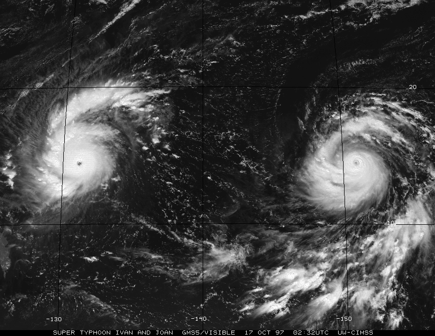
Re:
hurricanes1234 wrote:Thanks! I think it would be very interesting if we get two Category 5s at the same time in the same basin. Especially if they are open water fishes in the EPAC, oh! It doesn't get more interesting than that.
Well, if you're talking about just the same basin, I don't know if SuperTYs with the intensity of Ivan (155kt) and Joan (160kt) from 1997 had ever simultaneously existed before (they hadn't since reliable analysis tools or satellite existed), or will ever be seen, in such close proximity, again in my lifetime.
Date: 13-24 OCT 1997
Super Typhoon IVAN
ADV LAT LON TIME WIND PR STAT
15 14.60 133.10 10/16/18Z 115 - TYPHOON-4
16 14.70 131.60 10/17/00Z 140 - TYPHOON-5
17 14.70 130.40 10/17/06Z 140 - TYPHOON-5
18 14.40 129.60 10/17/12Z 155 - TYPHOON-5
19 14.60 128.30 10/17/18Z 160 - TYPHOON-5
20 14.90 127.30 10/18/00Z 150 - TYPHOON-5
21 15.20 126.30 10/18/06Z 145 - TYPHOON-5
21A 15.20 126.30 10/18/06Z 145 - TYPHOON-5
22 15.60 125.30 10/18/12Z 145 - TYPHOON-5
23 16.00 124.60 10/18/18Z 140 - TYPHOON-5
24 16.60 124.20 10/19/00Z 140 - TYPHOON-5
25 17.20 123.40 10/19/06Z 135 - TYPHOON-5
26 17.60 122.70 10/19/12Z 130 - TYPHOON-4
27 18.00 122.40 10/19/18Z 120 - TYPHOON-4
Date: 13-24 OCT 1997
Super Typhoon JOAN
ADV LAT LON TIME WIND PR STAT
15 13.80 153.40 10/16/18Z 125 - TYPHOON-4
16 14.10 151.60 10/17/00Z 125 - TYPHOON-4
17 14.40 150.00 10/17/06Z 155 - TYPHOON-5
18 14.80 148.80 10/17/12Z 160 - TYPHOON-5
19 15.30 147.10 10/17/18Z 140 - TYPHOON-5
20 16.00 145.70 10/18/00Z 135 - TYPHOON-5
21 16.50 144.30 10/18/06Z 140 - TYPHOON-5
21A 16.50 144.30 10/18/06Z 140 - TYPHOON-5
22 17.10 143.10 10/18/12Z 150 - TYPHOON-5
22A 17.10 143.10 10/18/12Z 150 - TYPHOON-5
23 17.70 141.80 10/18/18Z 145 - TYPHOON-5
24 18.10 140.70 10/19/00Z 145 - TYPHOON-5
25 18.50 139.80 10/19/06Z 140 - TYPHOON-5
26 19.00 138.80 10/19/12Z 140 - TYPHOON-5
27 19.50 138.00 10/19/18Z 140 - TYPHOON-5
28 20.10 137.50 10/20/00Z 140 - TYPHOON-5
0 likes
-
hurricanes1234
- Category 5
- Posts: 2903
- Joined: Sat Jul 28, 2012 6:19 pm
- Location: Trinidad and Tobago
Wow! That's absolutely stunning. The WPAC always comes in front of every other basin when it comes to strength and records!
0 likes
PLEASE NOTE: With the exception of information from weather agencies that I may copy and paste here, my posts will NEVER be official, since I am NOT a meteorologist. They are solely my amateur opinion, and may or may not be accurate. Therefore, please DO NOT use them as official details, particularly when making important decisions. Thank you.

Re: Simultaneous Major Hurricanes

Another view of twin Category 5 Ivan and Joan. Both systems reportedly reached a dvorak number of 8.0.
Gives you an idea what a strong el nino can bring to our area and were part of 10 category 5 that year.
1 likes
Remember, all of my post aren't official. For official warnings and discussions, Please refer to your local NWS products...
NWS for the Western Pacific
https://www.weather.gov/gum/
NWS for the Western Pacific
https://www.weather.gov/gum/
-
hurricanes1234
- Category 5
- Posts: 2903
- Joined: Sat Jul 28, 2012 6:19 pm
- Location: Trinidad and Tobago
Good thing we got this in recent times, or else we would have no images! I can't imagine what it would be like to have a season with 10 Category 5s in my lifetime. 
0 likes
PLEASE NOTE: With the exception of information from weather agencies that I may copy and paste here, my posts will NEVER be official, since I am NOT a meteorologist. They are solely my amateur opinion, and may or may not be accurate. Therefore, please DO NOT use them as official details, particularly when making important decisions. Thank you.
-
mrbagyo

- Category 5
- Posts: 3614
- Age: 31
- Joined: Thu Apr 12, 2012 9:18 am
- Location: 14.13N 120.98E
- Contact:
Re: Simultaneous Major Hurricanes
Typhoon Bonanza...
"The 1987 triplets"
From left to right of the image. winds are at 10 min ave. by JMA
Typhoon Gerald - 950 hPa / 80 kt
Typhoon Freda - 940 hPa / 85 kt
Typhoon Holly - 900 hPa / 110 kt

"The 1987 triplets"
From left to right of the image. winds are at 10 min ave. by JMA
Typhoon Gerald - 950 hPa / 80 kt
Typhoon Freda - 940 hPa / 85 kt
Typhoon Holly - 900 hPa / 110 kt
1 likes
The posts in this forum are NOT official forecast and should not be used as such. They are just the opinion of the poster and may or may not be backed by sound meteorological data. They are NOT endorsed by any professional institution or storm2k.org. For official information, please refer to RSMC, NHC and NWS products.
-
hurricanes1234
- Category 5
- Posts: 2903
- Joined: Sat Jul 28, 2012 6:19 pm
- Location: Trinidad and Tobago
Thanks very much to all those who have contributed and who may do so in the future. It is much appreciated!
0 likes
PLEASE NOTE: With the exception of information from weather agencies that I may copy and paste here, my posts will NEVER be official, since I am NOT a meteorologist. They are solely my amateur opinion, and may or may not be accurate. Therefore, please DO NOT use them as official details, particularly when making important decisions. Thank you.

Re: Simultaneous Major Hurricanes
I notice simultaneous major hurricanes in the Pacific occur during warm Pacific Decadal Oscillation (PDO). 1993 was Neutral ENSO bordering into El Nino.
0 likes
Re: Simultaneous Major Hurricanes
mrbagyo wrote:Typhoon Bonanza...
"The 1987 triplets"
From left to right of the image. winds are at 10 min ave. by JMA
Typhoon Gerald - 950 hPa / 80 kt
Typhoon Freda - 940 hPa / 85 kt
Typhoon Holly - 900 hPa / 110 kt
Keep up with the flow in 1 min...
Typhoon Gerald 105 knots
Typhoon Freda 125 knots
Super Typhoon Holly 140 knots...
That's 3 Major Hurricanes...
1 likes
Remember, all of my post aren't official. For official warnings and discussions, Please refer to your local NWS products...
NWS for the Western Pacific
https://www.weather.gov/gum/
NWS for the Western Pacific
https://www.weather.gov/gum/
Who is online
Users browsing this forum: duilaslol, JetFuel_SE and 180 guests