Expert forecasts for 2014 N Atl Hurricane season
Moderator: S2k Moderators
Forum rules

The posts in this forum are NOT official forecasts and should not be used as such. They are just the opinion of the poster and may or may not be backed by sound meteorological data. They are NOT endorsed by any professional institution or STORM2K. For official information, please refer to products from the National Hurricane Center and National Weather Service.
-
ninel conde
- Category 5

- Posts: 1245
- Joined: Mon Aug 04, 2008 2:18 pm
DT's hurricane forecast comes out this weekend.
0 likes
The posts in this forum are NOT official forecast and should not be used as such. They are just the opinion of the poster and may or may not be backed by sound meteorological data. They are NOT endorsed by any professional institution or storm2k.org. For official information, please refer to the NHC and NWS products.
-
cycloneye

- Admin

- Posts: 139027
- Age: 67
- Joined: Thu Oct 10, 2002 10:54 am
- Location: San Juan, Puerto Rico
Re: Expert forecasts=WSI is up (See first post)
WSI has released their June forecast.Read it at the first post.
0 likes
Visit the Caribbean-Central America Weather Thread where you can find at first post web cams,radars
and observations from Caribbean basin members Click Here
and observations from Caribbean basin members Click Here
-
cycloneye
- Admin
- Posts: 139027
- Age: 67
- Joined: Thu Oct 10, 2002 10:54 am
- Location: San Juan, Puerto Rico
Re: Expert forecasts=TSR July forecast (See first post)
TSR released the July forecast=Read it at first post. (12/5/2) The expectation of a Moderate El Nino and less warm ssts are the factors that lead them.
0 likes
Visit the Caribbean-Central America Weather Thread where you can find at first post web cams,radars
and observations from Caribbean basin members Click Here
and observations from Caribbean basin members Click Here
-
cycloneye
- Admin
- Posts: 139027
- Age: 67
- Joined: Thu Oct 10, 2002 10:54 am
- Location: San Juan, Puerto Rico
Re: Expert forecasts=CSU 7/31/14=9/3/1 (See first post)
Klotzbach/Gray updated forecast of August released on July 31rst paints a grim picture for the North Atlantic. The numbers are 9/3/1. Read the forecast that has 35 pages at the first post
0 likes
Visit the Caribbean-Central America Weather Thread where you can find at first post web cams,radars
and observations from Caribbean basin members Click Here
and observations from Caribbean basin members Click Here
-
wxman57

- Moderator-Pro Met

- Posts: 22480
- Age: 66
- Joined: Sat Jun 21, 2003 8:06 pm
- Location: Houston, TX (southwest)
Re: Expert forecasts=CSU updated forecast=10/4/1 (See first post
I corrected the CSU updated forecast to read 10/4/1. They're forecasting an additional 9/3/1
0 likes


I just read the updated forecast from the CSU team, they have noticed how bone dry the MDR is among many other things, could be a big reason why they are still forecasting a slower than average rest of the hurricane season despite neutral conditions remaining in Nino 3.4 and now a forecast of only a weak El Nino.
Image of bone dry July in the Atlantic:
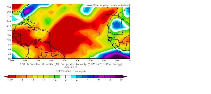
As was the case last year, the tropical Atlantic is much drier than normal this year. While there are issues with the NCEP/NCAR Reanalysis mid-level moisture estimates, it is likely that July 2014 is one of the driest Julys on record. The NCEP/NCAR Reanalysis reports that MDR 600-mb relative humidity in July 2014 is the driest on record by a large margin.
Figure 14: July 2014 600-mb relative humidity anomalies across the tropical Atlantic. Very dry conditions have been observed across the entire region.
According to AOML’s Jason Dunion (personal communication), African dust outbreaks have been quite strong this year as well. The Cooperative Research Institute for the Atmosphere (CIRA) monitors real-time conditions for genesis in the tropical Atlantic, and according to their analysis, vertical instability is significantly below normal this year (Figure 15). Positive deviations from the curve displayed below indicate a more unstable atmosphere than normal. In general, the atmosphere has been much more stable than normal since the start of the hurricane season.
Figure 15: Vertical instability across the tropical Atlantic since January 2014 (blue line). The average season is represented by the black line.
Table 8 summarizes conditions across both the MDR and Caribbean (10-20°N, 90-60°W) for July 2014 in standardized anomaly form from the 1981-2010 average. Several parameters are displayed in the table (including SST, SLP, 850-mb zonal wind, 200-mb zonal wind, 200-850-mb zonal wind shear and 600-mb relative humidity). Note that most parameter deviations in July 2014 are considered unfavorable for hurricane formation/intensification.
Image of bone dry July in the Atlantic:
0 likes
-
cycloneye
- Admin
- Posts: 139027
- Age: 67
- Joined: Thu Oct 10, 2002 10:54 am
- Location: San Juan, Puerto Rico
Re: Expert forecasts: TSR August forecast is up (See first post)
TSR August forecast is up at the first post. Here are the highlights:
TSR predicts North Atlantic basin tropical cyclone activity in 2014 will be about 30% below the long-term (1950-2013) norm and about 45% below the recent 2004-2013 10-year norm. U.S. landfalling hurricane activity is forecast to be about 25% below the 2004-2013 10-year norm.
TSR forecasts:
•An ACE (Accumulated Cyclone Energy) value of 70. The long-term and recent 2004-2013 norm values are 102 and 129 respectively.
•12 tropical storms including six hurricanes and two intense hurricanes. This compares to long-term norms of 11, six and three respectively, and to 2004-2013 norms of 16, eight and four respectively.
•A 50% likelihood that activity will be in the bottom one-third of years historically, a 39% likelihood it will be in the middle one-third of years historically and only a 11% chance it will be in the top one-third of years historically.
•Three tropical storms and two hurricane landfalls (including hurricane Arthur) on the U.S. mainland.
The main reasons behind TSR forecasting a below-normal season are (1) the expectation that August/September 2014 sea surface temperatures in the tropical North Atlantic will be cooler than average, and (2) the expectation of stronger than average trade winds over the Caribbean and tropical Atlantic during August/September 2014. The former provides heat and moisture to power incipient storms in the main track region, while the latter influences cyclonic vorticity (the spinning up of storms) in the main hurricane track region. Both these factors will have a small to moderate supressing effect on North Atlantic hurricane activity.
0 likes
Visit the Caribbean-Central America Weather Thread where you can find at first post web cams,radars
and observations from Caribbean basin members Click Here
and observations from Caribbean basin members Click Here
-
TheStormExpert

- Category 5
- Posts: 8487
- Age: 30
- Joined: Wed Feb 16, 2011 5:38 pm
- Location: Palm Beach Gardens, FL
-
cycloneye
- Admin
- Posts: 139027
- Age: 67
- Joined: Thu Oct 10, 2002 10:54 am
- Location: San Juan, Puerto Rico
Re: Expert forecasts:NOAA August forecast is up (See first post)
Read the August NOAA forecast at the first post. Below is the graphic with the numbers.

0 likes
Visit the Caribbean-Central America Weather Thread where you can find at first post web cams,radars
and observations from Caribbean basin members Click Here
and observations from Caribbean basin members Click Here
-
somethingfunny

- ChatStaff

- Posts: 3926
- Age: 35
- Joined: Thu May 31, 2007 10:30 pm
- Location: McKinney, Texas
Re: Expert forecasts:NOAA August forecast is up (See first post)
cycloneye wrote:Read the August NOAA forecast at the first post. Below is the graphic with the numbers.
So... since the Atlantic is already at 2/2/0.... that means that NOAA expects the remainder of 2014 to be 5-10/1-4/0-2, right?
I think that the upper end of that range sounds very reasonable. I don't think we'll exceed 12/6/2 in any category except perhaps a few extra weak tropical storms that just run up the alphabet usage,. The low end of that seems unlikely though. 7/3/0 would mean the rest of this season goes 5/1/0.... there's just no way, in my opinion.
Even last year did better than that in September alone. (Well, September 2013 was actually 4/2/0, but I think my point of that being unreasonably slow activity to expect for the entire remainder of the season is still a valid point)
0 likes
I am not a meteorologist, and any posts made by me are not official forecasts or to be interpreted as being intelligent. These posts are just my opinions and are probably silly opinions.
-
cycloneye
- Admin
- Posts: 139027
- Age: 67
- Joined: Thu Oct 10, 2002 10:54 am
- Location: San Juan, Puerto Rico
Re: Expert forecasts: CSU 2 week forecast up (See first post)
The CSU two week forecast from August 14 thru the 28th is up at the first post. The main words are below average next two weeks.
0 likes
Visit the Caribbean-Central America Weather Thread where you can find at first post web cams,radars
and observations from Caribbean basin members Click Here
and observations from Caribbean basin members Click Here
-
cycloneye
- Admin
- Posts: 139027
- Age: 67
- Joined: Thu Oct 10, 2002 10:54 am
- Location: San Juan, Puerto Rico
Re: Expert forecasts: CSU forecast Aug 28 thru Sep 11
CSU two week forecast from August 28th thru September 11 is up at the first post. Not a good picture to have many TC's in North Atlantic basin at peaktime.
0 likes
Visit the Caribbean-Central America Weather Thread where you can find at first post web cams,radars
and observations from Caribbean basin members Click Here
and observations from Caribbean basin members Click Here

Re: Expert forecasts: CSU forecast Aug 28 to Sep 10
I've got to ask this question about Global Weather Oscillations (GMO - David Dilley). Seems that at the beginning of the season, their Atlantic Seasonal forecast was based on research regarding something called Climate Pulse Technology. Contrary to most (or all) other conventional Weather Prediction services, GMO forecasted an above average season and multiple U.S. landfalls. I've looked at their web site and it makes for some entertaining reading, however no new updated forecast is shown nor can I seem to find practically any reference on the internet On their web site, there is a tremendous amount of info regarding how accurate "past" year predictions were, yet one must pay to receive detail of current one's.
I'm just curious if anyone has any credible information regarding this company that may be cross referenced by other sources. I could not find any discussion by them regarding recent analysis, new insights or updated forecast. In fact, I was unable to find any first hand video's, blogs, or recognizable media containing discussion or interview with this company. Oddly, there was practically zero reference to the company at all when simply searching founder's name or organization on a more local (Ocala, Fl) level either.
I'm just curious if anyone has any credible information regarding this company that may be cross referenced by other sources. I could not find any discussion by them regarding recent analysis, new insights or updated forecast. In fact, I was unable to find any first hand video's, blogs, or recognizable media containing discussion or interview with this company. Oddly, there was practically zero reference to the company at all when simply searching founder's name or organization on a more local (Ocala, Fl) level either.
0 likes
Personal Forecast Disclaimer:
The posts in this forum are NOT official forecast and should not be used as such. They are just the opinion of the poster and may or may not be backed by sound meteorological data. They are NOT endorsed by any professional institution or storm2k.org. For official information, please refer to the NHC and NWS products.
The posts in this forum are NOT official forecast and should not be used as such. They are just the opinion of the poster and may or may not be backed by sound meteorological data. They are NOT endorsed by any professional institution or storm2k.org. For official information, please refer to the NHC and NWS products.

CSU latest forecast is up. Nothing new from them, expecting the next several weeks to remain below average. It's cool to see that they have incorporated Kelvin Wave information provided by Dr. Ventrice, invaluable tool that has proven to be effective not just for the Atlantic but globally. Planetary waves definitely is an area we could further research that would benefit greatly for Tropical seasons to come.
0 likes
The above post and any post by Ntxw is NOT an official forecast and should not be used as such. It is just the opinion of the poster and may or may not be backed by sound meteorological data. It is NOT endorsed by any professional institution including Storm2k. For official information, please refer to NWS products.
Help support Storm2K!
-
cycloneye
- Admin
- Posts: 139027
- Age: 67
- Joined: Thu Oct 10, 2002 10:54 am
- Location: San Juan, Puerto Rico
Re: Expert forecasts: CSU forecast Sept 11 to Sep 24
Read the two week forecast by CSU from September 11 thru the 24th at first post. Another below average period.
0 likes
Visit the Caribbean-Central America Weather Thread where you can find at first post web cams,radars
and observations from Caribbean basin members Click Here
and observations from Caribbean basin members Click Here
-
cycloneye
- Admin
- Posts: 139027
- Age: 67
- Joined: Thu Oct 10, 2002 10:54 am
- Location: San Juan, Puerto Rico
Re: Expert forecasts: CSU forecast Sept 25 to Oct 8
The last two week forecast by CSU is up at the first post. Another below average period is what they forecast.
0 likes
Visit the Caribbean-Central America Weather Thread where you can find at first post web cams,radars
and observations from Caribbean basin members Click Here
and observations from Caribbean basin members Click Here
CSU released their final update for Oct-Nov period. Says below average (3 ACE to normal of 6.3). Their hind-cast verification this year has been very good especially with ACE, one of the best in some years for the 2 week periods they've been forecasting.
0 likes
The above post and any post by Ntxw is NOT an official forecast and should not be used as such. It is just the opinion of the poster and may or may not be backed by sound meteorological data. It is NOT endorsed by any professional institution including Storm2k. For official information, please refer to NWS products.
Help support Storm2K!
Help support Storm2K!
-
cycloneye
- Admin
- Posts: 139027
- Age: 67
- Joined: Thu Oct 10, 2002 10:54 am
- Location: San Juan, Puerto Rico
Re: Expert forecasts: CSU October/November=Below average
As Ntxw said,CSU released the October/November forecast and is another below average period. Read it at first post of thread.
0 likes
Visit the Caribbean-Central America Weather Thread where you can find at first post web cams,radars
and observations from Caribbean basin members Click Here
and observations from Caribbean basin members Click Here
Just like that Gonzalo defied CSU Oct-Nov call and ACE gets racked up above normal. Makes last forecast of the season by CSU a bad one, the irony.
0 likes
The above post and any post by Ntxw is NOT an official forecast and should not be used as such. It is just the opinion of the poster and may or may not be backed by sound meteorological data. It is NOT endorsed by any professional institution including Storm2k. For official information, please refer to NWS products.
Help support Storm2K!
Help support Storm2K!
-
TheStormExpert
- Category 5
- Posts: 8487
- Age: 30
- Joined: Wed Feb 16, 2011 5:38 pm
- Location: Palm Beach Gardens, FL
Re:
Ntxw wrote:Just like that Gonzalo defied CSU Oct-Nov call and ACE gets racked up above normal. Makes last forecast of the season by CSU a bad one, the irony.
CSU has really been hurting with their predictions these past three seasons. (2012-2014)
0 likes
The following post is NOT an official forecast and should not be used as such. It is just the opinion of the poster and may or may not be backed by sound meteorological data. It is NOT endorsed by storm2k.org.
Who is online
Users browsing this forum: TheAustinMan, zal0phus and 156 guests