
Temporarily continuing the "off topic" discussion; I'm glad that Frank clarified his comment about the NHC including future issues in the TWO. I think the more, the better and am glad to see them now including areas still not off the coast.
Sometimes, I think they should include areas that have future model consensus on even if nothing is occurring at the time of the 5 day forecast.
It's a "forecast" up to 5 days out so if the NHC believes something might happen, then they should include it.
I NEVER believe in the holding back of information!
Off SE U.S coast (Is Invest 91L)
Moderator: S2k Moderators
Forum rules

The posts in this forum are NOT official forecasts and should not be used as such. They are just the opinion of the poster and may or may not be backed by sound meteorological data. They are NOT endorsed by any professional institution or STORM2K. For official information, please refer to products from the National Hurricane Center and National Weather Service.
0 likes
Personal Forecast Disclaimer:
My posts are just my opinion and are most likely not backed by sound meteorological data. They are NOT endorsed by any professional institution or storm2k.org. For official information, please refer to the NHC and NWS products.
Bottom line is that I am just expressing my opinion!!!
My posts are just my opinion and are most likely not backed by sound meteorological data. They are NOT endorsed by any professional institution or storm2k.org. For official information, please refer to the NHC and NWS products.
Bottom line is that I am just expressing my opinion!!!
-
Kingarabian

- S2K Supporter

- Posts: 15434
- Joined: Sat Aug 08, 2009 3:06 am
- Location: Honolulu, Hawaii
Re:
fci wrote:Temporarily continuing the "off topic" discussion; I'm glad that Frank clarified his comment about the NHC including future issues in the TWO. I think the more, the better and am glad to see them now including areas still not off the coast.
Sometimes, I think they should include areas that have future model consensus on even if nothing is occurring at the time of the 5 day forecast.
It's a "forecast" up to 5 days out so if the NHC believes something might happen, then they should include it.
I NEVER believe in the holding back of information!
They are doing that for the Eastern Pacific, currently.
0 likes
RIP Kobe Bryant
-
SeGaBob

Re:
TheStormExpert wrote::uarrow: What about TS Beryl(2012)? Seems like a perfect analog to me?
No, I don't think so, Beryl started as a cold core system then became tropical as it traveled over the Gulf Stream. This current system is not a cold core system.
0 likes
-
Hurricaneman

- Category 5

- Posts: 7281
- Age: 43
- Joined: Tue Aug 31, 2004 3:24 pm
- Location: central florida
Re:
SeGaBob wrote:It looks like it should be moving offshore in just a couple of hours...does anyone think chances will be raised at 2am?
maybe even an invest might be declared and I wouldn't be surprised if they're trying to schedule a recon mission
0 likes
-
hurrtracker79
- Tropical Depression

- Posts: 94
- Joined: Sun Jul 28, 2013 1:32 pm
Re: Off SE U.S coast?
Where can you go to see what the active Invests are? I used to have the link. Anyone? Thx!
0 likes
-
lester

- S2K Supporter
- Posts: 1305
- Age: 35
- Joined: Sat Aug 27, 2005 5:21 pm
- Location: Washington, DC
- Contact:
A WEAK NON-TROPICAL AREA OF LOW PRESSURE IS MOVING SOUTHEASTWARD
OFF THE COAST OF SOUTH CAROLINA. SOME GRADUAL DEVELOPMENT OF THIS
SYSTEM IS POSSIBLE WHILE IT LINGERS OFF THE SOUTHEASTERN COAST OF
THE UNITED STATES THROUGH THE MIDDLE OF NEXT WEEK.
* FORMATION CHANCE THROUGH 48 HOURS...LOW...10 PERCENT.
* FORMATION CHANCE THROUGH 5 DAYS...MEDIUM...30 PERCENT.
OFF THE COAST OF SOUTH CAROLINA. SOME GRADUAL DEVELOPMENT OF THIS
SYSTEM IS POSSIBLE WHILE IT LINGERS OFF THE SOUTHEASTERN COAST OF
THE UNITED STATES THROUGH THE MIDDLE OF NEXT WEEK.
* FORMATION CHANCE THROUGH 48 HOURS...LOW...10 PERCENT.
* FORMATION CHANCE THROUGH 5 DAYS...MEDIUM...30 PERCENT.
0 likes
-
bamajammer4eva
- Category 4

- Posts: 907
- Joined: Sun Apr 18, 2010 3:21 am
- Location: Ozark, AL
Re: Off SE U.S coast?
hurrtracker79 wrote:Where can you go to see what the active Invests are? I used to have the link. Anyone? Thx!
Navy site:
http://www.nrlmry.navy.mil/tc_pages/tc_home.html
Looks like they took down their FTP/atcf tcinvest folder as they said they would after last year to avoid confusion over people prematurely upgrading invests.
It was somewhere here
http://ftp.nhc.noaa.gov/atcf/
0 likes
-
beoumont

- Category 1

- Posts: 473
- Joined: Sun Jul 10, 2011 4:13 pm
- Location: East Central Florida
- Contact:
Re: Off SE U.S coast?
Cute. Flash in pan? Image from 5 am.

0 likes
List of 79 tropical cyclones intercepted by Richard Horodner:
http://www.canebeard.com/page/page/572246.htm
http://www.canebeard.com/page/page/572246.htm
-
Hurricane_Luis

- Category 2

- Posts: 723
- Age: 26
- Joined: Sat Jun 23, 2012 3:14 pm
- Location: Tiptree, Essex, United Kingdom
- Contact:
Re: Off SE U.S coast?
hurrtracker79 wrote:Where can you go to see what the active Invests are? I used to have the link. Anyone? Thx!
I use this one, It doesn't update as frequently as the others but it does the job. They are also links to satellite loops.
http://www.ssd.noaa.gov/PS/TROP/floaters.html
0 likes
-
northjaxpro

- S2K Supporter
- Posts: 8900
- Joined: Mon Sep 27, 2010 11:21 am
- Location: Jacksonville, FL
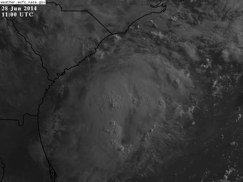
Looks real good at this early morning hour. The Low Pressure area appears to be nearing or about to emerge offshore. Convection really has become concentrated and we are beginning to see some curvature to the structure. I expect invest designation immediately today.
Last edited by northjaxpro on Sat Jun 28, 2014 6:15 am, edited 1 time in total.
0 likes
NEVER, EVER SAY NEVER in the tropics and weather in general, and most importantly, with life itself!!
________________________________________________________________________________________
Fay 2008 Beryl 2012 Debby 2012 Colin 2016 Hermine 2016 Julia 2016 Matthew 2016 Irma 2017 Dorian 2019
________________________________________________________________________________________
Fay 2008 Beryl 2012 Debby 2012 Colin 2016 Hermine 2016 Julia 2016 Matthew 2016 Irma 2017 Dorian 2019
Re: Off SE U.S coast?
Yeap, looking good this morning, convection maintained during the night over the warm waters of the Atlantic, though it looks like the mid level vorticity & deep convection is displaced further south from the weak surface low.
Meanwhile models overnight have shifted in bringing the possible system closer to FL over the next 3 days, with the NAM being the most aggressive and closest to FL. The Euro still shows that if the low tracks closer to the coast the better UL conditions it will have with an UL ridge staying put near the FL/GA coastal waters.
Meanwhile models overnight have shifted in bringing the possible system closer to FL over the next 3 days, with the NAM being the most aggressive and closest to FL. The Euro still shows that if the low tracks closer to the coast the better UL conditions it will have with an UL ridge staying put near the FL/GA coastal waters.
0 likes
Up to a Medium chance now within 48 hrs.
TROPICAL WEATHER OUTLOOK
NWS NATIONAL HURRICANE CENTER MIAMI FL
800 AM EDT SAT JUN 28 2014
For the North Atlantic...Caribbean Sea and the Gulf of Mexico:
1. A weak low pressure system located just off the coast of South
Carolina is producing an area of disorganized showers and
thunderstorms. Environmental conditions are expected to remain
conducive for gradual development of this system while
it drifts southward during the next few days.
* Formation chance through 48 hours...medium...30 percent.
* Formation chance through 5 days...medium...50 percent.
Forecaster Brown
0 likes


-
TheEuropean

- Professional-Met

- Posts: 1793
- Age: 58
- Joined: Tue Sep 20, 2005 3:17 pm
- Location: Voerde, Germany
- Contact:
Who is online
Users browsing this forum: cycloneye, Google Adsense [Bot], terstorm1012 and 189 guests