Cyclonic Turning in the Atlantic
Moderator: S2k Moderators
Forum rules

The posts in this forum are NOT official forecasts and should not be used as such. They are just the opinion of the poster and may or may not be backed by sound meteorological data. They are NOT endorsed by any professional institution or STORM2K. For official information, please refer to products from the National Hurricane Center and National Weather Service.
Cyclonic Turning in the Atlantic
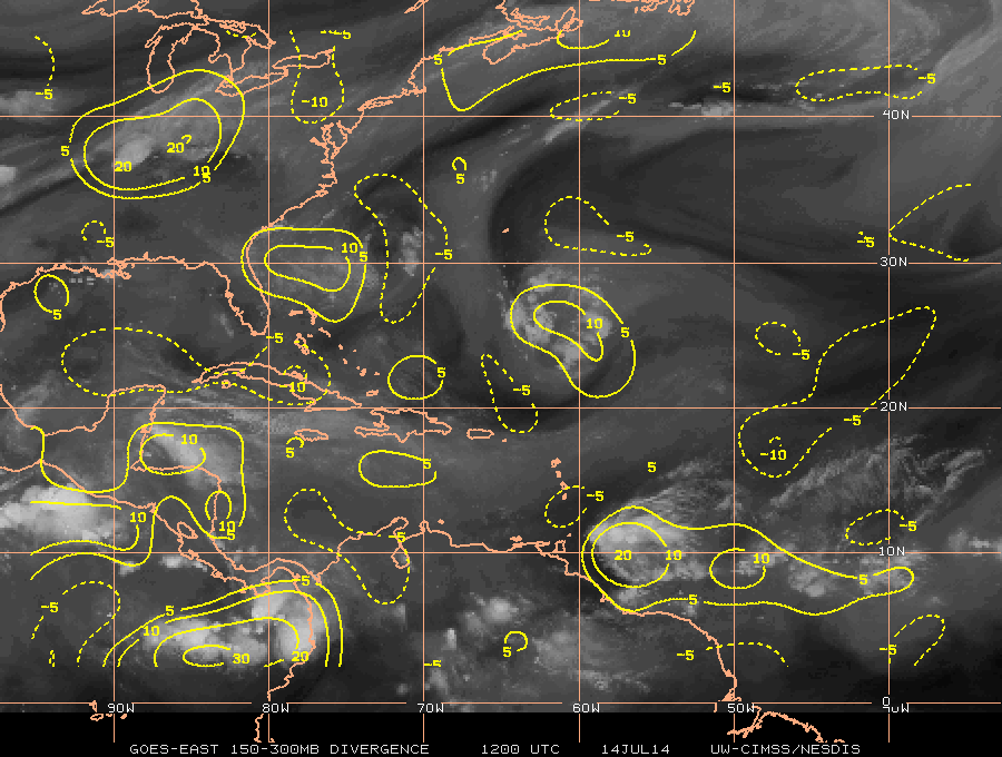
Kind of boring right now, here is some decent turning a ways out in the Atlantic http://weather.msfc.nasa.gov/cgi-bin/ge ... =Animation supported by vorticity at 850 http://tropic.ssec.wisc.edu/real-time/w ... oom=&time= low level convergence http://tropic.ssec.wisc.edu/real-time/w ... oom=&time= and upper divergence http://tropic.ssec.wisc.edu/real-time/w ... oom=&time=
0 likes
-
floridasun78
- Category 5

- Posts: 3755
- Joined: Sun May 17, 2009 10:16 pm
- Location: miami fl
-
tropicwatch

- Category 5
- Posts: 3205
- Age: 60
- Joined: Sat Jun 02, 2007 10:01 am
- Location: Panama City Florida
- Contact:
Re: Cyclonic Turning in the Atlantic
Quite a bit of dry air around it.
0 likes
Tropicwatch
Agnes 72', Eloise 75, Elena 85', Kate 85', Charley 86', Florence 88', Beryl 94', Dean 95', Erin 95', Opal 95', Earl 98', Georges 98', Ivan 2004', Arlene 2005', Dennis 2005', Ida 2009' Debby 2012' Irma 2017' Michael 2018'
Agnes 72', Eloise 75, Elena 85', Kate 85', Charley 86', Florence 88', Beryl 94', Dean 95', Erin 95', Opal 95', Earl 98', Georges 98', Ivan 2004', Arlene 2005', Dennis 2005', Ida 2009' Debby 2012' Irma 2017' Michael 2018'
-
Dean4Storms
- S2K Supporter

- Posts: 6355
- Age: 61
- Joined: Sun Aug 31, 2003 1:01 pm
- Location: Miramar Bch. FL
-
Dean4Storms
- S2K Supporter
- Posts: 6355
- Age: 61
- Joined: Sun Aug 31, 2003 1:01 pm
- Location: Miramar Bch. FL
Re: Cyclonic Turning in the Atlantic
Anyone seen the area this evening east of Florida?
http://www.ssd.noaa.gov/goes/east/carb/flash-vis.html
http://www.ssd.noaa.gov/goes/east/carb/flash-vis.html
0 likes
Re: Cyclonic Turning in the Atlantic
Dean4Storms wrote:Is this in reference to the area about 400 miles east of Florida right now increasing in convection or the area out near 65W?
The one by 65w, the one right off Florida looks mainly upper level, but that can change.
Here it is the 65w one from the 2am tropical weather discussion
----------------------------------------------------------------------------------
A MIDDLE TO UPPER LEVEL LOW IS CENTERED NEAR 30N63W THAT CONTINUES
TO SUPPORTS A SURFACE TROUGH ANALYZED FROM 23N67W TO 30N67W. AN
AREA OF WIDELY SCATTERED SHOWERS AND TSTMS IS OCCURRING PRIMARILY
EAST OF THE SURFACE TROUGH AXIS FROM 22N-32N BETWEEN 59W-66W.
Ramsdis has a nice loop of it http://rammb.cira.colostate.edu/ramsdis ... display=12 note though, no surface winds showing any circulation.
0 likes
Who is online
Users browsing this forum: Google Adsense [Bot], Ian2401, Long John, Sciencerocks, StPeteMike and 195 guests