When will the multi-decade active era that began in 1995 end?

This is the general tropical discussion area. Anyone can take their shot at predicting a storms path.

Moderator: S2k Moderators

Forum rules

The posts in this forum are NOT official forecasts and should not be used as such. They are just the opinion of the poster and may or may not be backed by sound meteorological data. They are NOT endorsed by any professional institution or STORM2K. For official information, please refer to products from the National Hurricane Center and National Weather Service.

Help Support Storm2K
Message
Author
User avatar
Andrew92
S2K Supporter
S2K Supporter
Posts: 3247
Age: 40
Joined: Mon Jun 16, 2003 12:35 am
Location: Phoenix, Arizona

Re: Re:

#161 Postby Andrew92 » Thu Nov 26, 2015 4:05 pm

Alyono wrote:
Andrew92 wrote:Don't overlook 1959 though. That season was like 1983 in several ways, but in a more favorable period for storms to form in the Atlantic. If the active period is still going on, I might compare 2016 to 1959 if the setup is similar.

La Nina was stronger at the equator in 1959 than 1983, but there were healthy warm anomalies where most EPAC hurricanes form. Like 1983, the MDR was all but shut down in 1959, with only Edith (which dissipated quickly) and Flora (which re-curved quickly) form south of 20 degrees that year.

Furthermore, both season had two hurricanes apiece in the Gulf, and the United States had a major hurricane hit the coast somewhere in both years: Gracie hit South Carolina in 1959 and Alicia hit Texas in 1983. As a bonus, there was even a major October EPAC hurricane that slammed into Mexico in both 1959 and 1983.

The only key difference between those two years, other than numbers and overall activity, is that 1959 was in an active Atlantic period and 1983 was in an inactive one. As such, there were more storms in 1959, but little overall quality. If you think there were 7 hurricanes that year looking at HURDAT, I will call to attention that two may be on the verge of being downgraded, and a third may have only been a hurricane for a few hours. Not too much more active than 1983 from that standpoint, really.

-Andrew92


not sure about a 1959 as some of those systems formed from waves and not nontropical systems, like what formed in 1983. Is it possible that the warm anomalies were slightly less in 1959 compared to 1983? I am asking as some of the waves seemed to survive into the Gulf where development occurred, whereas they were destroyed entirely in 1983


I don't think the warm anomalies were less in 1959 versus 1983, but it was further west, namely a large pool south and southwest of Baja, and I think some very weak warm anomalies getting closer to the coast. 1983's warm anomalies, as I recall, were right off Central America.

My source for this paragraph is by and large Wikipedia, so take what I am saying here with a grain of salt, as I just don't have time to go further with Thanksgiving today and all. Obviously, Edith and Flora were from tropical waves, and Gracie isn't a surprise either, nor is Judith. What did surprise me was that Arlene was fully from a wave, and even Debra was somewhat caused by a tropical wave. I would have guessed, without researching, that Debra was fully of frontal nature like Alicia (it appears to have been partially frontal, though). Probably the biggest surprise was the June unnamed storm (one of the two maybe on the way down to a tropical storm, perhaps becoming extratropical before gaining hurricane-force winds). I would have said that was likely fully frontal also, especially given the path, but it looks like it was a tropical wave after all.

Also, Wikipedia says Barry came from a tropical disturbance in 1983. But again, give me time to go further and actually read NHC and AOML reports to truly verify these, maybe over the weekend sometime.

Still, these waves clearly struggled in the MDR and Caribbean in 1959, and couldn't really get going until they got either into the EPAC or a little further north. I wouldn't rule out a scenario like 1959 at all next year.

-Andrew92
0 likes   

User avatar
Andrew92
S2K Supporter
S2K Supporter
Posts: 3247
Age: 40
Joined: Mon Jun 16, 2003 12:35 am
Location: Phoenix, Arizona

#162 Postby Andrew92 » Thu Nov 26, 2015 8:55 pm

OK, I have an update to my previous post about the 1959 season....

I just reviewed HURAKAN/Sandy Delgado's master's thesis, in the 1959 storm updates section. Pending the full re-analysis, the following storms that year definitely formed from tropical waves:

Arlene
Edith
Flora
Gracie
Hannah
Judith

That is six, though there was a complicated setup in June that led to Beulah and the unnamed June storm forming nearly at the same time. It appears a cold front did produce a lot of unsettled weather in the Gulf at around that time, while a tropical wave appears to have combined with the mess that was going on. (I can only wonder what that might have looked like on satellite!) It appears one storm formed from the front (probably Beulah), and the other came from this tropical wave (like the unnamed storm, which quickly got caught up into the atmosphere forcing it northeast).

I'm not sure why Wikipedia suggested a tropical wave might have helped spawn Debra. The thesis makes it pretty clear that Debra came from a frontal low. Three more storms were also added, all of which came from nontropical origins.

Also, I looked at NHC's report on Barry in 1983. It did come from a tropical disturbance, the only named storm in the Atlantic that year to come from fully tropical origins.

So all in all, tropical waves had quite greater success in becoming tropical storms in 1959 than in 1983. However, the fact remains that only Edith was a storm south of 20 degrees that year, and she was short-lived. And still half of the storms likely had frontal origins that year, depending on what happens with the new storms he found.

That said, this thesis is unofficial. I am really hoping the 1956-1960 re-analysis is complete during the offseason, to get a full view of what 1959 really was like and if that year could be as promising of an analog for 2016 as I suspect it could be.

-Andrew92

EDIT due to typos. I hate having my computer hit the fritz and resorting to my phone!!!
Last edited by Andrew92 on Thu Nov 26, 2015 11:17 pm, edited 1 time in total.
0 likes   

User avatar
WPBWeather
S2K Supporter
S2K Supporter
Posts: 535
Age: 65
Joined: Thu Jul 18, 2013 12:33 pm

Re: Re:

#163 Postby WPBWeather » Thu Nov 26, 2015 9:51 pm

Alyono wrote:
WPBWeather wrote:
Alyono wrote:fear mongering by Bastardi


Perhaps, or perhaps not. As a ProMet, are you really buying into only PAC activity and no ATL activity? Seems counter to history and science to me. Too much focus on the PAC lets people think ATL cyclones are a thing of the past.


It follows science to a T. It also follows historical precedent with the decay of the 1982 el niño

I see two main possibilities for next year. The first is a 1983-like season. The second is a hyperactive Atlantic due to the warm waters. From what I have seen to date (which of course can change), the 1983-like appears to be the most likely scenario as the PDO is likely to remain positive, which keeps the waters north of the equator warm. This means the ascending motion is over the Pacific, with very strong shear over possible the entire MDR, not just the Caribbean as we saw this year.

There is a 3rd option of near normal activity where if the warm waters north of the equator cool late to allow for an active late September and October. I consider that to be the 3rd most likely scenario, however.


Scripps data seem to support the Bastardi idea. I respect your opinion, but there is room for JB's scenario.
0 likes   

User avatar
gigabite
S2K Supporter
S2K Supporter
Posts: 916
Age: 70
Joined: Wed May 05, 2004 4:09 pm
Location: Naples, Florida

Re: Has the multi-decade active era since 1995 ended?

#164 Postby gigabite » Thu Nov 26, 2015 10:01 pm

I have a 40% lunar sub-point correlation for 1998, and a 60% lunar sub-point correlation for 1993. 1993 had a ACE of 39 compared to a 59 so far for 2015. There was a software upgrade in 2006 that improved the sensitivity of the satellite constellation to account for. 1993 was an el Nino year also.

1959 shows up on my plot, but doesn't register a correlation, and neither 1983 or 1997 register on the plot.
0 likes   

User avatar
Andrew92
S2K Supporter
S2K Supporter
Posts: 3247
Age: 40
Joined: Mon Jun 16, 2003 12:35 am
Location: Phoenix, Arizona

#165 Postby Andrew92 » Thu Nov 26, 2015 11:23 pm

What is JB's scenario?

Also, if forecasts are right next year, I have a difficult time comparing 2016 to 1993, but not as much with 1998, assuming that's what you are referring to Gigabyte. The reason being is it looks like we have a pretty good La Nina coming down the pipe, off the heels of a strong El Nino, much like 1997-98 and not really like 1992-93.

1957 was also a strong El Nino, but was followed by another El Nino year, albeit weaker, in 1958, before La Nina finally took over. In a sense, this stands to be like the period of 1957-1959, but in a shorter timespan.

-Andrew92
0 likes   

User avatar
WPBWeather
S2K Supporter
S2K Supporter
Posts: 535
Age: 65
Joined: Thu Jul 18, 2013 12:33 pm

Re: Has the multi-decade active era since 1995 ended?

#166 Postby WPBWeather » Fri Nov 27, 2015 12:33 am

gigabite wrote:I have a 40% lunar sub-point correlation for 1998, and a 60% lunar sub-point correlation for 1993. 1993 had a ACE of 39 compared to a 59 so far for 2015. There was a software upgrade in 2006 that improved the sensitivity of the satellite constellation to account for. 1993 was an el Nino year also.

1959 shows up on my plot, but doesn't register a correlation, and neither 1983 or 1997 register on the plot.


Is this a good or bad thing?
0 likes   

tolakram
Admin
Admin
Posts: 19165
Age: 60
Joined: Sun Aug 27, 2006 8:23 pm
Location: Florence, KY (name is Mark)

Re:

#167 Postby tolakram » Fri Nov 27, 2015 8:51 am

Andrew92 wrote:What is JB's scenario?


-Andrew92


On the pay site he doesn't offer much, he lets the tweets stir up excitement. Last year when the models started showing a strong el nino they were not to be trusted. This year when showing a rapid drop to la nina they are to be trusted. I really don't think we have any idea what next year is going to be like yet.
0 likes   
M a r k
- - - - -
Join us in chat: Storm2K Chatroom Invite. Android and IOS apps also available.

The posts in this forum are NOT official forecasts and should not be used as such. Posts are NOT endorsed by any professional institution or STORM2K.org. For official information and forecasts, please refer to NHC and NWS products.

User avatar
gigabite
S2K Supporter
S2K Supporter
Posts: 916
Age: 70
Joined: Wed May 05, 2004 4:09 pm
Location: Naples, Florida

Re: Has the multi-decade active era since 1995 ended?

#168 Postby gigabite » Fri Nov 27, 2015 5:20 pm

WPBWeather wrote:
gigabite wrote:I have a 40% lunar sub-point correlation for 1998, and a 60% lunar sub-point correlation for 1993. 1993 had a ACE of 39 compared to a 59 so far for 2015. There was a software upgrade in 2006 that improved the sensitivity of the satellite constellation to account for. 1993 was an el Nino year also.

1959 shows up on my plot, but doesn't register a correlation, and neither 1983 or 1997 register on the plot.


Is this a good or bad thing?

Its a dry thing.
* The ongoing warming trend in the Pacific has been accompanied by a global drying trend. The storm count in the Atlantic is moisture dependent.
* The satellite software upgrade can pickup a spin-up earlier than the previous version because it is better able to distinguish between upper level and lower level features. This makes the 10 day forecast more reliable. The down side is hind casting using storm totals before 2006 has no field ratio to account for the improvement.
* Analog storms not on my dot plot are being referenced to a non-mechanical (aka weather trend) datum.
0 likes   

Alyono
Professional-Met
Professional-Met
Posts: 6961
Joined: Fri Apr 26, 2013 3:52 pm
Location: Texas Coast

#169 Postby Alyono » Fri Dec 04, 2015 1:37 pm

seeing 1992 may also be a good analog for next year. Came out of a strong el niño, yet we had warmer waters just north of the equator, which led record activity in the EPAC and CPAC. MDR was dead. Even Andrew did next to nothing until it moved north of the MDR. That year after reanalysis may be simillar to 1959

Just not seeing the hyperactivity that some are saying. The analogs simply do not support it. However, years coming off an el niño almost always have Gulf hurricanes, regardless as to the level of Atlantic activity
0 likes   

User avatar
Andrew92
S2K Supporter
S2K Supporter
Posts: 3247
Age: 40
Joined: Mon Jun 16, 2003 12:35 am
Location: Phoenix, Arizona

#170 Postby Andrew92 » Sat Dec 05, 2015 3:26 am

The following post is NOT an official forecast and should not be used as such. It is just the opinion of the poster and may or may not be backed by sound meteorological data. It is NOT endorsed by any professional institution or storm2k.org. For official information, please refer to the NHC and NWS products.

At the very least, I want to mention what either we know will happen or what is probably going to happen for 2016 in terms of a setup.

The first thing that we all know is 2015 was a quite strong El Nino year. However, one need only to look at water temperature anomalies further west in the Pacific to know a cold pool is looming and spreading east. This will likely mean an end to this event to begin the 2016 season.

So 2016 stands to be the first year after an El Nino. These types of years have a reputation for being quite dangerous. But are they really? In this case, some know that I like to look at years following traditional El Nino events and Modoki El Nino events separately. However, I have discovered some tendencies in the first year after any El Nino event, traditional or Modoki, that are similar across the board.

I will start with Alyono's comment about the Gulf of Mexico. He mentioned in the post right above this very one that almost every year immediately after an El Nino features hurricanes in the Gulf. This is absolutely true, and since the 1950s, I can only think of 1978 that did not have any hurricanes in the Gulf immediately after an El Nino year of any kind.

Of course, one might beg the question, which years had major hurricanes in the Gulf immediately after an El Nino? Keep in mind, I like to consider any hurricane with a pressure below 965 mb on par with being a major, going off of the Saffir/Simpson scale's recommendation for categories by pressure. A quick review reveals that a majority of those years do have at least one major hurricane in the Gulf of Mexico the year after an El Nino. The years following an El Nino without majors there since the 1950s, when also accounting for pressure, include 1954, 1959, 1973, 1978, 2003, and 2007. The other first-years-after included as follows:

1964: Hilda
1966: Alma (questionable) and Inez
1970: Celia and a questionable Ella
1980: Allen
1983: Alicia
1988: Gilbert
1992: Andrew
1995: Opal
1998: Georges (Category 2 by wind, but pressure was below 965)
2005: Dennis, Emily, Katrina, Rita, and Wilma
2010: Alex (again, pressure below 965) and Karl

So in 17 such years, there have been 16 good majors in the Gulf and two questionable ones, Alma because it was quite early in June and pressure was 970 mb allegedly, while Ella was 967 at the lowest for now (maybe they'll stand though, we'll see).

However, I harped for a good chunk of this year how rare going two consecutive years without a single hurricane in the Gulf is. Well, it ended up happening. The odds are even slimmer that none will take place there at all next year. In fact, in my research earlier this year, I couldn't find a single instance since 1886 of three straight years with no Gulf hurricanes. The most recent official instance was 1907-08, and 1909 was quite nasty in the Gulf with the Grand Isle and Velasco hurricanes. That said, 1962 had a hurricane-free Gulf and Cindy in 1963 may get downgraded to a tropical storm, the only storm in the Gulf that year. And 1964....had Hilda. 1981-82 was also close, if not for Alberto. 1983, of course, had Alicia.

So the odds, based on these two trends, favor a quite nasty Gulf hurricane in 2016. But what about a landfall?

Of the 16 good majors, eleven hit the United States and five hit Mexico. However, only four struck east of the Mississippi: Opal, Georges, Dennis, and Wilma. The rest of the US majors all hit Louisiana or Texas. So the odds would favor the western Gulf much more for a big hit than the eastern Gulf.

Now, many will ask, when will it form, and where might it come from? Unfortunately, all I can really say for timing is that August and September are far more likely than any other month, though three of them have hit in October: Hilda, Opal, and Wilma. Dennis also did hit in July. Where they will come from is a only slightly easier to answer. Six of these majors formed either right in the Gulf or in the western Caribbean, leaving five to form further east. So, it's about a 50/50 chance it could be homegrown or a long-tracker.

However, let's go back to the Pacific SST anomaly forecasts for 2016. While La Nina looks likely at the Equator, what happens north of there can have just as significant of impacts. Some models do show continued warming, say between 10-20 degrees north or so. 1959 had a pattern like that, along with 1992, a fair distance offshore. But even from a ways off Central America, it caused those years to behave in ways like El Nino years. The EPAC was busy both years (especially 1992), with almost ironically, Hawaii getting hits too in both seasons! But the Atlantic....well, the tropical latitudes were practically dead. Edith died quickly, while Flora re-curved and survived in 1959. Andrew also barely survived at first until finding more favorable conditions at about 25 degrees. And both years had several storms of non-tropical origins develop.

One difference between 1959 and 1992 is storms that managed to form from tropical waves. Besides Edith and Flora, they all got further north in 1959. Arlene, an unnamed storm, Gracie, Hannah, and Judith all formed from tropical origins. But tropical waves couldn't reach those latitudes in 1992, and struggled. I think the difference is obvious: 1959 was during an active Atlantic phase, whereas 1992 was during an inactive phase.

As for 1983, I will talk about that if El Nino is still flexing some muscle in the Equator as late as August which appears to have been the case that year. But for now, I like 1959 and 1992 as the top analogs, leaning 1959 as I think 2015 having 11 storms in this strong El Nino may be a harbinger of the active period still going on. But I am also cognizant that the Gulf is due for a biggie next year, which didn't happen in 1959 but did in 1992. Any major that hits the Gulf in 2016 will probably hit the western half based on what usually happens the first year after an El Nino.

I have been wrong on these analyses so many times though, and I am almost sure to be wrong somewhere here again. Remember, I am just an amateur trying to make sense of all this. Enjoy the offseason, hopefully next year is inactive, but it only takes one to make the season.

-Andrew92

EDIT: Forgot 2005 came right after an El Nino year.
0 likes   

User avatar
Ptarmigan
Category 5
Category 5
Posts: 5272
Joined: Wed Aug 16, 2006 9:06 pm

Re: Has the multi-decade active era since 1995 ended?

#171 Postby Ptarmigan » Mon Dec 07, 2015 10:45 pm

1957-1958 was a Modoki El Nino. The 1950s was in the warm phase of the Atlantic. 1980s was in the cool phase of the Atlantic.

You can check out SST.
http://apdrc.soest.hawaii.edu/las8/UI.vm
0 likes   

tolakram
Admin
Admin
Posts: 19165
Age: 60
Joined: Sun Aug 27, 2006 8:23 pm
Location: Florence, KY (name is Mark)

Re: Has the multi-decade active era since 1995 ended?

#172 Postby tolakram » Thu Dec 10, 2015 1:56 pm

Does ninel work for the Washington Post? :D

Recurring East Coast low pressure may be saving U.S. from major hurricanes
By Phil Klotzbach and Brian McNoldy December 9

https://www.washingtonpost.com/news/cap ... urricanes/
0 likes   
M a r k
- - - - -
Join us in chat: Storm2K Chatroom Invite. Android and IOS apps also available.

The posts in this forum are NOT official forecasts and should not be used as such. Posts are NOT endorsed by any professional institution or STORM2K.org. For official information and forecasts, please refer to NHC and NWS products.

User avatar
cycloneye
Admin
Admin
Posts: 139058
Age: 67
Joined: Thu Oct 10, 2002 10:54 am
Location: San Juan, Puerto Rico

Re: Has the multi-decade active era since 1995 ended?

#173 Postby cycloneye » Fri Jan 08, 2016 10:21 am

Interesting development that Dr Klotzbach points out.

Philip Klotzbach ‏@philklotzbach · 13m13 minutes ago
North Atlantic SST pattern in December 2015 vastly different from the active era Dec average. AMO switching phase?

Image
0 likes   
Visit the Caribbean-Central America Weather Thread where you can find at first post web cams,radars
and observations from Caribbean basin members Click Here

User avatar
Andrew92
S2K Supporter
S2K Supporter
Posts: 3247
Age: 40
Joined: Mon Jun 16, 2003 12:35 am
Location: Phoenix, Arizona

#174 Postby Andrew92 » Fri Jan 08, 2016 1:54 pm

This certainly could change my top analog from 1959 to 1992 if I can find more data from December 1958 and 1991, though I am also interested in December 1982 as well for 1983 purposes. This isn't to say I don't think 2016 will be at all similar to 1959, as according to model projections, it certainly still could be, at least in the EPAC.

I tried to replicate that graphic above though and must be missing something. Is anyone able to assist? Here is the link for queries:
http://www.esrl.noaa.gov/psd/cgi-bin/da ... intpage.pl

The parameters I am using are as follows:
Variable: SST (NCEP Reanalysis Model)
Beginning and ending month is December for both
Range of years 2015 to 2015, minus 1995 to 2012
Type of Comparison: Anomaly, greater or equal to value
Plot type: Anomaly
Map projection: Custom (0-70 latitude, 260-360 longitude, Cylindrical Equidistant)

Can someone please help me where I am wrong? Mine looks nowhere close to Phil's.

Thank you in advance!

-Andrew92
0 likes   

User avatar
Andrew92
S2K Supporter
S2K Supporter
Posts: 3247
Age: 40
Joined: Mon Jun 16, 2003 12:35 am
Location: Phoenix, Arizona

#175 Postby Andrew92 » Fri Jan 08, 2016 8:30 pm

The following post is NOT an official forecast and should not be used as such. It is just the opinion of the poster and may or may not be backed by sound meteorological data. It is NOT endorsed by any professional institution or storm2k.org. For official information, please refer to the NHC and NWS products.

Never mind my question above. It turns out I didn't account for the intervals. It has to be .1 intervals with a range from -1.5 to 1.5, along with everything else I mentioned above, to get that image.

With that figured out, I did a little digging. Like I have said, if we are interested in 1959, 1983, and 1992 as potential analogs given the EPAC SST forecast for July 2016, then we should compare that graphic above to December 1958, 1982, and 1991.

And oh boy, if you think it was cold in December, change the year in the range to either 1982 or 1991. There were purples everywhere! Much colder in December of those years than 2015. This past December was closest to December 1958 of the set, but even that year, the Atlantic looks cooler overall than December 2015.

This is still looking like a 1959-esque setup, in my opinion. I just wish data in the Pacific was better back then, because I would be awfully intrigued to find out what the CPAC was like in terms of activity even before that season began. Of course, a lot can change between now and then.

-Andrew92
0 likes   

User avatar
gigabite
S2K Supporter
S2K Supporter
Posts: 916
Age: 70
Joined: Wed May 05, 2004 4:09 pm
Location: Naples, Florida

Re: Has the multi-decade active era since 1995 ended?

#176 Postby gigabite » Sun Jan 10, 2016 6:03 pm

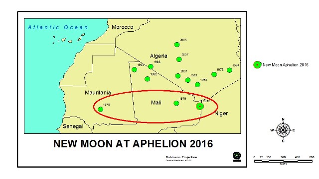
Here is a Atlantic hurricane development train of thought I'm following. Global cloud cover right now is the highest it has been in three years. I believe that total global water vapor is a major factor in tropical cyclone development. Turbulence is a catalysis and water vapor is the reactant. If the surface area of water is increasing then it must follow that water vapor must increase. My analog is the 1979 position.
0 likes   

User avatar
WPBWeather
S2K Supporter
S2K Supporter
Posts: 535
Age: 65
Joined: Thu Jul 18, 2013 12:33 pm

Re: Has the multi-decade active era since 1995 ended?

#177 Postby WPBWeather » Mon Jan 11, 2016 12:15 am

Nope, it has not ended in my opinion anyway. Phil K. has some interesting ideas on this topic, but there is not much science to back him up on this ideas about ocean salinity levels or on blocking permanent low pressure systems. Larry Cosgrove also has some interesting thoughts on the upcoming 2016 season, which can be viewed on WeatherAmerica on Google. The bottom line is that we need to wait and see.
0 likes   

User avatar
gigabite
S2K Supporter
S2K Supporter
Posts: 916
Age: 70
Joined: Wed May 05, 2004 4:09 pm
Location: Naples, Florida

Re: Has the multi-decade active era since 1995 ended?

#178 Postby gigabite » Tue Jan 12, 2016 9:12 pm

gigabite wrote:Here is a Atlantic hurricane development train of thought I'm following. Global cloud cover right now is the highest it has been in three years. I believe that total global water vapor is a major factor in tropical cyclone development. Turbulence is a catalysis and water vapor is the reactant. If the surface area of water is increasing then it must follow that water vapor must increase. My analog is the 1979 position.


1978 is also on my map as an analog year.

Image
0 likes   

User avatar
cycloneye
Admin
Admin
Posts: 139058
Age: 67
Joined: Thu Oct 10, 2002 10:54 am
Location: San Juan, Puerto Rico

Re: Has the multi-decade active era since 1995 ended?

#179 Postby cycloneye » Wed Jan 20, 2016 10:45 am

Phil Klotzbach was talking about the topic of if the active era has ended or not in a NWS forum.

http://www.stormcenter.com/wxcsummit/live.html

Scroll down to see the highlights of his discussion:

"Potentially we may have moved out the active phase in the Atlantic in 2012, driven by changes in salinity." Phil Klotzbach, CSU

Image

"Hurricane seasons in Atlantic were extraordinarily quiet in 1970-94, perhaps quietest 25 yrs in centuries" Phil Klotzbach, CSU

"North Atlantic has been cold and continues to be cold. This can lead to more frequent, stronger #ElNino's" Phil Klotzbach, CSU

Image

This is very interesting. "Last 3 Septembers have been extraordinary quiet. Haven't been that quiet since 1912-1914." Phil Klotzbach, CSU
0 likes   
Visit the Caribbean-Central America Weather Thread where you can find at first post web cams,radars
and observations from Caribbean basin members Click Here

User avatar
WPBWeather
S2K Supporter
S2K Supporter
Posts: 535
Age: 65
Joined: Thu Jul 18, 2013 12:33 pm

Re: Has the multi-decade active era since 1995 ended?

#180 Postby WPBWeather » Wed Jan 20, 2016 10:49 pm

And now for something completely different...

Not too many people buy the salinity theory from Phil K.

This is from Geophysical Research Letters, so it has some street cred, as it were.

Atlantic, Caribbean storms more destructive as temperatures rise
Thomson Reuters
Sebastien Malo
Jan 20th 2016 4:09PM

http://www.aol.com/article/2016/01/20/a ... ws-main-bb
0 likes   


Return to “Talkin' Tropics”

Who is online

Users browsing this forum: EquusStorm, KirbyDude25, Kohlecane, zzzh and 148 guests