Area of Disturbed Weather in NW Caribbean

This is the general tropical discussion area. Anyone can take their shot at predicting a storms path.

Moderator: S2k Moderators

Forum rules

The posts in this forum are NOT official forecasts and should not be used as such. They are just the opinion of the poster and may or may not be backed by sound meteorological data. They are NOT endorsed by any professional institution or STORM2K. For official information, please refer to products from the National Hurricane Center and National Weather Service.

Help Support Storm2K
Message
Author
User avatar
gatorcane
S2K Supporter
S2K Supporter
Posts: 23499
Age: 46
Joined: Sun Mar 13, 2005 3:54 pm
Location: Boca Raton, FL

Area of Disturbed Weather in NW Caribbean

#1 Postby gatorcane » Wed Sep 03, 2014 10:47 am

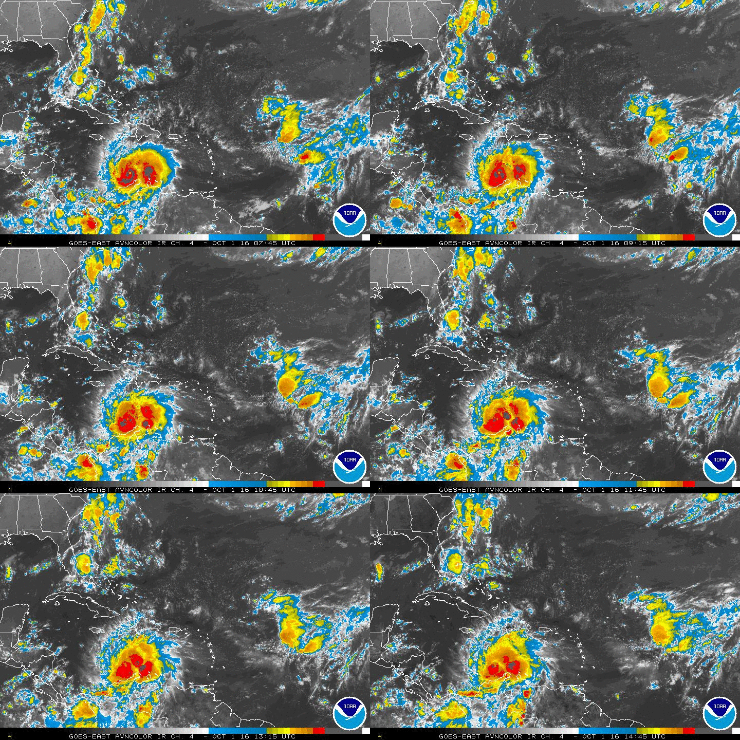
The GFS model continues to show a sharp increase in convection over the SW Caribbean spreading north through the weekend. Looking down there today, we can see some deep convection starting. Could we see some possible development?

Here is the 12Z Simulated IR image, 66 hours from now, saved image:
Image

Current IR Satellite, saved image:
Image
Last edited by gatorcane on Sun Sep 07, 2014 9:24 am, edited 5 times in total.
0 likes   

User avatar
northjaxpro
S2K Supporter
S2K Supporter
Posts: 8900
Joined: Mon Sep 27, 2010 11:21 am
Location: Jacksonville, FL

#2 Postby northjaxpro » Wed Sep 03, 2014 10:49 am

It's possible. There has been model support showing something developing and moving northwest and then into the BOC area in the next few days. Will watch the region closely.
0 likes   
NEVER, EVER SAY NEVER in the tropics and weather in general, and most importantly, with life itself!!

________________________________________________________________________________________

Fay 2008 Beryl 2012 Debby 2012 Colin 2016 Hermine 2016 Julia 2016 Matthew 2016 Irma 2017 Dorian 2019

bohaiboy
Tropical Depression
Tropical Depression
Posts: 86
Joined: Sat Aug 09, 2008 11:20 am

Re: Area of Disturbed Weather in SW Caribbean

#3 Postby bohaiboy » Wed Sep 03, 2014 12:04 pm

Our private weather service here also notes to keep a careful watch on this region. They put development late next week. They also mention possible development from the front currently swinging down.
0 likes   
TW in Texas Hill Country :flag:

User avatar
gatorcane
S2K Supporter
S2K Supporter
Posts: 23499
Age: 46
Joined: Sun Mar 13, 2005 3:54 pm
Location: Boca Raton, FL

#4 Postby gatorcane » Wed Sep 03, 2014 4:47 pm

18Z GFS simulated IR rolling now is showing the current area of disturbed weather flaring up quite a bit this weekend:
Image
0 likes   

User avatar
TheStormExpert
Category 5
Category 5
Posts: 8487
Age: 30
Joined: Wed Feb 16, 2011 5:38 pm
Location: Palm Beach Gardens, FL

#5 Postby TheStormExpert » Wed Sep 03, 2014 9:01 pm

No way any sort of TC will form with this kind of screaming shear. Try Eastern GoM, or off the SE Coast.

Image
0 likes   
The following post is NOT an official forecast and should not be used as such. It is just the opinion of the poster and may or may not be backed by sound meteorological data. It is NOT endorsed by storm2k.org.

YoshiMike
Tropical Storm
Tropical Storm
Posts: 106
Age: 28
Joined: Wed Aug 27, 2014 9:18 pm
Location: Hattiesburg, MS
Contact:

#6 Postby YoshiMike » Thu Sep 04, 2014 12:14 am

why havent i noticed this?
0 likes   
Okay guys, just because I want to BE a meteorologist, want to go to school for meteorology, DOES NOT MAKE ME A METEOROLOGIST. Anything I say about tropical weather is either me learning something new, or is just an opinion and nothing more than that. I can almost guarantee you that I will be wrong about pretty much everything.

User avatar
Hurricaneman
Category 5
Category 5
Posts: 7281
Age: 43
Joined: Tue Aug 31, 2004 3:24 pm
Location: central florida

#7 Postby Hurricaneman » Thu Sep 04, 2014 12:23 am

The GFS has this area from the 18z run going into Texas and the 0zrun heading into Tampico so its still way too far out to see where this one goes or if it even develops

The posts in this forum are NOT official forecast and should not be used as such. They are just the opinion of the poster and may or may not be backed by sound meteorological data. They are NOT endorsed by any professional institution or storm2k.org. For official information, please refer to the NHC and NWS products
0 likes   

User avatar
Hammy
Category 5
Category 5
Posts: 5594
Age: 40
Joined: Fri May 25, 2012 5:25 pm
Contact:

Re:

#8 Postby Hammy » Thu Sep 04, 2014 12:33 am

TheStormExpert wrote:No way any sort of TC will form with this kind of screaming shear. Try Eastern GoM, or off the SE Coast.


The models aren't showing anything immediate, more like 3-5 days, which means that in all likelihood the pattern will change by then.
0 likes   
The above post is not official and should not be used as such. It is the opinion of the poster and may or may not be backed by sound meteorological data. It is not endorsed by any professional institution or storm2k.org. For official information, please refer to the NHC and NWS products.

User avatar
tropicwatch
Category 5
Category 5
Posts: 3205
Age: 60
Joined: Sat Jun 02, 2007 10:01 am
Location: Panama City Florida
Contact:

Re: Area of Disturbed Weather in SW Caribbean

#9 Postby tropicwatch » Thu Sep 04, 2014 7:30 am

Looks like we will need to rename this thread NW Caribbean because it does look like this area will make it there.

Image
0 likes   
Tropicwatch


Agnes 72', Eloise 75, Elena 85', Kate 85', Charley 86', Florence 88', Beryl 94', Dean 95', Erin 95', Opal 95', Earl 98', Georges 98', Ivan 2004', Arlene 2005', Dennis 2005', Ida 2009' Debby 2012' Irma 2017' Michael 2018'

User avatar
tropicwatch
Category 5
Category 5
Posts: 3205
Age: 60
Joined: Sat Jun 02, 2007 10:01 am
Location: Panama City Florida
Contact:

Re: Area of Disturbed Weather in SW Caribbean

#10 Postby tropicwatch » Thu Sep 04, 2014 8:56 am

There is some heavy duty wind shear in that area right now.

Image
0 likes   
Tropicwatch


Agnes 72', Eloise 75, Elena 85', Kate 85', Charley 86', Florence 88', Beryl 94', Dean 95', Erin 95', Opal 95', Earl 98', Georges 98', Ivan 2004', Arlene 2005', Dennis 2005', Ida 2009' Debby 2012' Irma 2017' Michael 2018'

User avatar
NDG
S2K Supporter
S2K Supporter
Posts: 14933
Joined: Sun Jul 09, 2006 10:14 pm
Location: Orlando, FL

#11 Postby NDG » Thu Sep 04, 2014 9:12 am

:uarrow: Models show that ULL move NW while UL heights rise across the central and western Caribbean this weekend. A lot of that shear on the map above is more of high shear relatively speaking because of the strong low level jet across the central Caribbean Sea. So don't look for anything to get organize at the surface across the central Caribbean because of the strong low level jet, it will have to be way west in the extreme SW Caribbean into the BOC, IMO.
0 likes   

User avatar
tropicwatch
Category 5
Category 5
Posts: 3205
Age: 60
Joined: Sat Jun 02, 2007 10:01 am
Location: Panama City Florida
Contact:

#12 Postby tropicwatch » Thu Sep 04, 2014 9:14 am

"SW Caribbean into the BOC"

Did you mean NW?
0 likes   
Tropicwatch


Agnes 72', Eloise 75, Elena 85', Kate 85', Charley 86', Florence 88', Beryl 94', Dean 95', Erin 95', Opal 95', Earl 98', Georges 98', Ivan 2004', Arlene 2005', Dennis 2005', Ida 2009' Debby 2012' Irma 2017' Michael 2018'

User avatar
NDG
S2K Supporter
S2K Supporter
Posts: 14933
Joined: Sun Jul 09, 2006 10:14 pm
Location: Orlando, FL

Re:

#13 Postby NDG » Thu Sep 04, 2014 9:23 am

panamatropicwatch wrote:"SW Caribbean into the BOC"

Did you mean NW?


SW section of the NW Caribbean, is what I meant.
0 likes   

USTropics
Category 5
Category 5
Posts: 2410
Joined: Sun Aug 12, 2007 3:45 am
Location: Florida State University

#14 Postby USTropics » Thu Sep 04, 2014 9:30 am

This is what NDG is referring to visually from the 06z GFS run. This is forecasted shear in 72 hours showing lowering values in the NW Caribbean:

Image
0 likes   

Alyono
Professional-Met
Professional-Met
Posts: 6961
Joined: Fri Apr 26, 2013 3:52 pm
Location: Texas Coast

#15 Postby Alyono » Thu Sep 04, 2014 11:18 am

GFS has development at 144 hours
0 likes   

Alyono
Professional-Met
Professional-Met
Posts: 6961
Joined: Fri Apr 26, 2013 3:52 pm
Location: Texas Coast

#16 Postby Alyono » Thu Sep 04, 2014 11:37 am

sends it into Mexico and then the monsoon trough spins up another system
0 likes   

User avatar
somethingfunny
ChatStaff
ChatStaff
Posts: 3926
Age: 35
Joined: Thu May 31, 2007 10:30 pm
Location: McKinney, Texas

Re: Area of Disturbed Weather in SW Caribbean

#17 Postby somethingfunny » Thu Sep 04, 2014 12:31 pm

The Canadian is migrating this over to the EPAC
0 likes   
I am not a meteorologist, and any posts made by me are not official forecasts or to be interpreted as being intelligent. These posts are just my opinions and are probably silly opinions.

Sanibel
Category 5
Category 5
Posts: 10348
Joined: Mon Aug 30, 2004 11:06 pm
Location: Offshore SW Florida

Re: Area of Disturbed Weather in SW Caribbean

#18 Postby Sanibel » Thu Sep 04, 2014 12:42 pm

The disturbance appears to be EPAC bound.
0 likes   

User avatar
gatorcane
S2K Supporter
S2K Supporter
Posts: 23499
Age: 46
Joined: Sun Mar 13, 2005 3:54 pm
Location: Boca Raton, FL

#19 Postby gatorcane » Thu Sep 04, 2014 7:23 pm

Convection increasing big time as the GFS model projected...

Image
0 likes   

Frank P
S2K Supporter
S2K Supporter
Posts: 2408
Joined: Fri Aug 29, 2003 10:52 am
Location: Biloxi Beach, Ms

Re:

#20 Postby Frank P » Thu Sep 04, 2014 7:28 pm

gatorcane wrote:Convection increasing big time as the GFS model projected...

Image


Looks to be going more northerly than west... overall looks NNW to NW to me... this may not make it to the EPAC....
0 likes   


Return to “Talkin' Tropics”

Who is online

Users browsing this forum: duilaslol and 207 guests